Dixie, Tennessee
Submit your own pictures of this place and show them to the world
- OSM Map
- General Map
- Google Map
- MSN Map

| Males: 1,062 | |
| Females: 1,124 |
| Median resident age: | 40.0 years |
| Tennessee median age: | 35.9 years |
Zip code: 38260
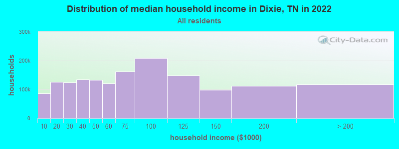
| Dixie: | $63,318 |
| TN: | $65,254 |
Estimated per capita income in 2022: $32,032 (it was $19,024 in 2000)
Dixie CCD income, earnings, and wages data
Estimated median house or condo value in 2022: $160,231 (it was $70,700 in 2000)
| Dixie: | $160,231 |
| TN: | $284,800 |
Detailed information about poverty and poor residents in Dixie, TN


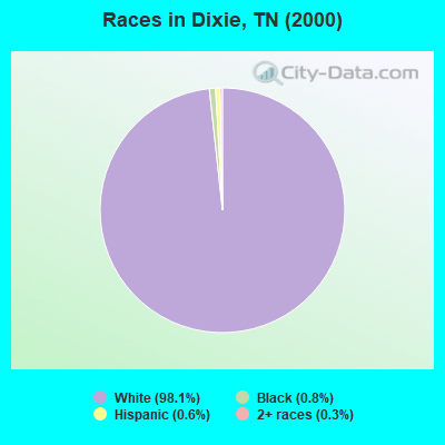
- 2,20898.1%White alone
- 180.8%Black alone
- 140.6%Hispanic
- 60.3%Two or more races
- 20.09%American Indian alone
- 20.09%Asian alone
Races in Dixie detailed stats: ancestries, foreign born residents, place of birth
 Recent articles from our blog. Our writers, many of them Ph.D. graduates or candidates, create easy-to-read articles on a wide variety of topics.
Current Local Time: CST time zone
Elevation: 487 feet
Land area: 73.2 square miles.
Population density: 30 people per square mile (very low).

| Dixie CCD: | 0.6% ($438) |
| Tennessee: | 0.8% ($715) |
Nearest city with pop. 50,000+: Jackson, TN  (61.6 miles , pop. 59,643).
Nearest city with pop. 200,000+: Memphis, TN (101.6 miles , pop. 650,100).
Nearest city with pop. 1,000,000+: Chicago, IL (381.4 miles , pop. 2,896,016).
Nearest cities:
), ), Latitude: 36.46 N, Longitude: 89.23 W

| Here: | 3.4% |
| Tennessee: | 3.0% |
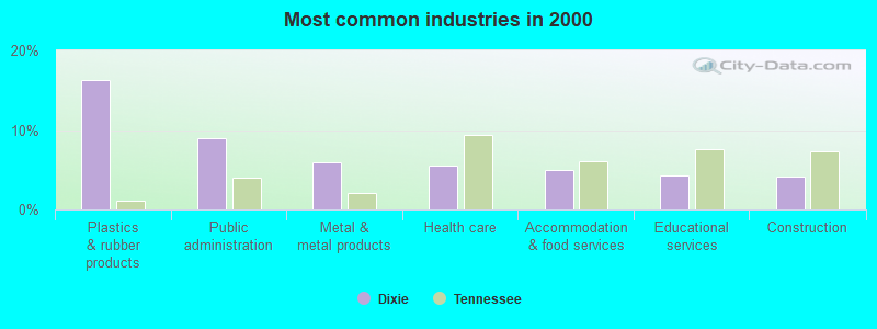
- Plastics & rubber products (16.3%)
- Public administration (9.0%)
- Metal & metal products (5.9%)
- Health care (5.5%)
- Accommodation & food services (5.0%)
- Educational services (4.3%)
- Construction (4.1%)
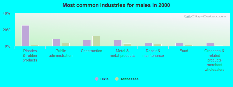
- Plastics & rubber products (25.7%)
- Public administration (8.9%)
- Construction (7.6%)
- Metal & metal products (7.6%)
- Repair & maintenance (4.3%)
- Food (4.0%)
- Groceries & related products merchant wholesalers (4.0%)
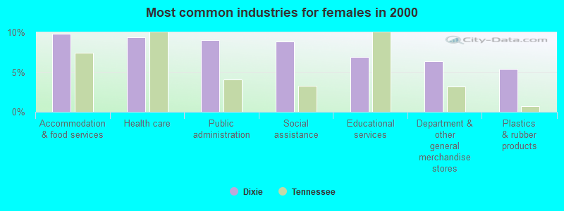
- Accommodation & food services (9.8%)
- Health care (9.4%)
- Public administration (9.0%)
- Social assistance (8.8%)
- Educational services (6.9%)
- Department & other general merchandise stores (6.3%)
- Plastics & rubber products (5.4%)
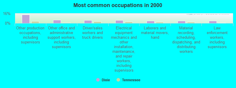
- Other production occupations, including supervisors (13.9%)
- Other office and administrative support workers, including supervisors (5.3%)
- Driver/sales workers and truck drivers (5.0%)
- Electrical equipment mechanics and other installation, maintenance, and repair workers, including supervisors (4.6%)
- Laborers and material movers, hand (4.1%)
- Material recording, scheduling, dispatching, and distributing workers (4.0%)
- Law enforcement workers, including supervisors (3.7%)
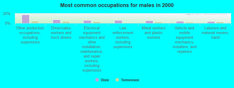
- Other production occupations, including supervisors (20.9%)
- Driver/sales workers and truck drivers (8.4%)
- Electrical equipment mechanics and other installation, maintenance, and repair workers, including supervisors (7.6%)
- Law enforcement workers, including supervisors (7.0%)
- Metal workers and plastic workers (6.3%)
- Vehicle and mobile equipment mechanics, installers, and repairers (5.1%)
- Laborers and material movers, hand (4.1%)
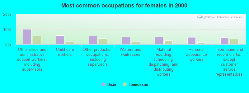
- Other office and administrative support workers, including supervisors (10.2%)
- Child care workers (6.0%)
- Other production occupations, including supervisors (5.8%)
- Waiters and waitresses (5.2%)
- Material recording, scheduling, dispatching, and distributing workers (5.2%)
- Personal appearance workers (4.8%)
- Information and record clerks, except customer service representatives (4.6%)
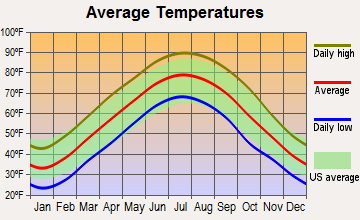
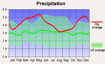
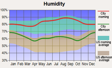
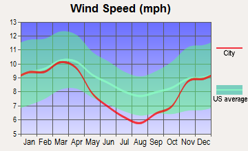
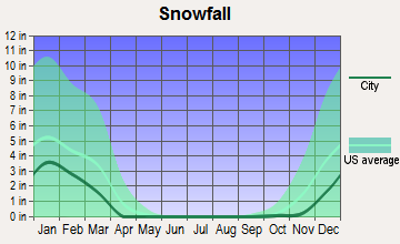
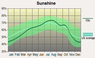
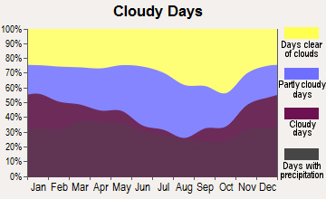
Average climate in Dixie, Tennessee
Based on data reported by over 4,000 weather stations
(lower is better)
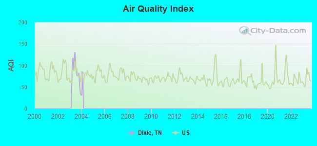
Air Quality Index (AQI) level in 2003 was 83.0. This is about average.
| City: | 83.0 |
| U.S.: | 72.6 |
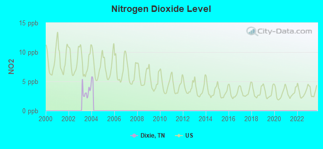
Nitrogen Dioxide (NO2) [ppb] level in 2003 was 3.30. This is significantly better than average. Closest monitor was 9.2 miles away from the city center.
| City: | 3.30 |
| U.S.: | 5.11 |
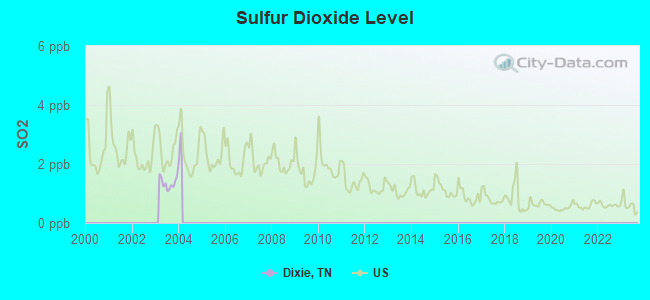
Sulfur Dioxide (SO2) [ppb] level in 2003 was 1.35. This is about average. Closest monitor was 9.2 miles away from the city center.
| City: | 1.35 |
| U.S.: | 1.51 |
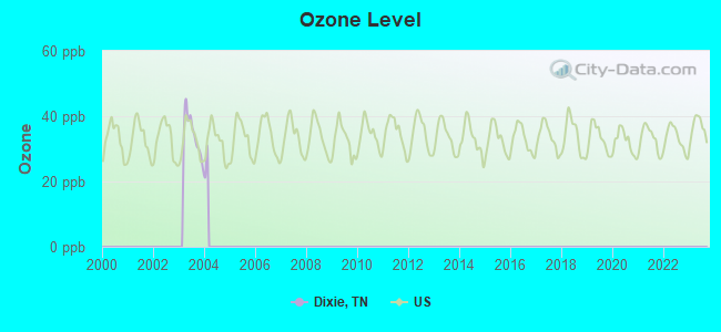
Ozone [ppb] level in 2003 was 34.2. This is about average. Closest monitor was 7.4 miles away from the city center.
| City: | 34.2 |
| U.S.: | 33.3 |
Tornado activity:
Dixie-area historical tornado activity is slightly above Tennessee state average. It is 94% greater than the overall U.S. average.
On 3/1/1997, a category F4 (max. wind speeds 207-260 mph) tornado 23.6 miles away from the Dixie place center injured 15 people and caused $2 million in damages.
On 3/21/1952, a category F4 tornado 24.9 miles away from the place center killed 4 people and injured 5 people and caused between $50,000 and $500,000 in damages.
Earthquake activity:
Dixie-area historical earthquake activity is significantly above Tennessee state average. It is 383% greater than the overall U.S. average.On 5/4/1991 at 01:18:54, a magnitude 5.0 (4.4 MB, 4.6 LG, 5.0 LG, Depth: 3.1 mi, Class: Moderate, Intensity: VI - VII) earthquake occurred 33.5 miles away from the city center
On 9/26/1990 at 13:18:51, a magnitude 5.0 (4.7 MB, 4.8 LG, 5.0 LG, Depth: 7.7 mi) earthquake occurred 51.7 miles away from the city center
On 4/18/2008 at 09:36:59, a magnitude 5.4 (5.1 MB, 4.8 MS, 5.4 MW, 5.2 MW) earthquake occurred 156.5 miles away from the city center
On 3/25/1976 at 00:41:20, a magnitude 5.0 (4.9 MB, 5.0 LG) earthquake occurred 83.5 miles away from the city center
On 4/27/1989 at 16:47:49, a magnitude 4.7 (4.6 MB, 4.7 LG, 4.3 LG, Class: Light, Intensity: IV - V) earthquake occurred 43.2 miles away from the city center
On 4/18/2008 at 09:36:59, a magnitude 5.2 (5.2 MW, Depth: 8.9 mi) earthquake occurred 156.4 miles away from Dixie center
Magnitude types: regional Lg-wave magnitude (LG), body-wave magnitude (MB), surface-wave magnitude (MS), moment magnitude (MW)
Natural disasters:
The number of natural disasters in Obion County (14) is near the US average (15).Major Disasters (Presidential) Declared: 11
Emergencies Declared: 1
Causes of natural disasters: Floods: 12, Storms: 10, Tornadoes: 4, Winds: 3, Winter Storms: 2, Hurricane: 1, Landslide: 1, Mudslide: 1, Other: 1 (Note: some incidents may be assigned to more than one category).
Hospitals and medical centers near Dixie:
- OBION COUNTY NURSING HOME (Nursing Home, about 7 miles away; UNION CITY, TN)
- EXTENDICARE HOME HEALTH OF WESTERN TN (Home Health Center, about 11 miles away; UNION CITY, TN)
- BAPTIST MEMORIAL HOSPITAL UNION CITY Acute Care Hospitals (about 11 miles away; UNION CITY, TN)
- RCG UNION CITY (Dialysis Facility, about 12 miles away; UNION CITY, TN)
- UNION CITY MANOR (Nursing Home, about 12 miles away; UNION CITY, TN)
- UNION CITY MANOR NURSING CENTER (Nursing Home, about 12 miles away; UNION CITY, TN)
- GOLDEN LIVING CENTER - UNION CITY (Nursing Home, about 12 miles away; UNION CITY, TN)
Colleges/universities with over 2000 students nearest to Dixie:
- The University of Tennessee-Martin (about 23 miles; Martin, TN; Full-time enrollment: 7,013)
- Dyersburg State Community College (about 30 miles; Dyersburg, TN; FT enrollment: 2,211)
- Bethel University (about 46 miles; McKenzie, TN; FT enrollment: 5,878)
- Murray State University (about 52 miles; Murray, KY; FT enrollment: 8,930)
- West Kentucky Community and Technical College (about 53 miles; Paducah, KY; FT enrollment: 4,107)
- Union University (about 59 miles; Jackson, TN; FT enrollment: 4,051)
- Southeast Missouri State University (about 62 miles; Cape Girardeau, MO; FT enrollment: 9,678)
Points of interest:
Notable locations in Dixie: Straders Boat Dock (A), Snaggy Opening (B), Devils Race Track (C), Burnt Woods (D), Beech (E), Reelfoot Lake Biological Station (F). Display/hide their locations on the map
Churches in Dixie include: Fremont Church of Christ (A), Reelfoot Church (B), Sanders Chapel (C), Walnut Log Baptist Church (D), Antioch Church (E), Old Republican Church (F), Beech Chapel (G), Mount Olive Church (H), Mount Manuel Church (I). Display/hide their locations on the map
Cemeteries: Walker Cemetery (1), Fremont Cemetery (2), Beech Cemetery (3), Antioch Cemetery (4), Crescent Cemetery (5). Display/hide their locations on the map
Lakes, reservoirs, and swamps: Buck Basin (A), Mud Basin (B), Brewer Basin (C), Carey Basin (D), Glory Hole (E), Bo Pocket (F), Rat Pocket (G), Yankapin Basin (H). Display/hide their locations on the map
Streams, rivers, and creeks: Hamblin Branch (A), Cane Creek (B), Tull Creek (C), Bogus Creek (D), Black Slough (E), Big Sandy Creek (F), Scawley Creek (G), Opossum Branch (H), Taylor Creek (I). Display/hide their locations on the map
Park in Dixie: Reelfoot National Wildlife Refuge (1). Display/hide its location on the map
| This place: | 2.6 people |
| Tennessee: | 2.5 people |
| This place: | 69.4% |
| Whole state: | 69.8% |
| This place: | 3.0% |
| Whole state: | 4.2% |
Likely homosexual households (counted as self-reported same-sex unmarried-partner households)
- Lesbian couples: 0.2% of all households
- Gay men: 0.2% of all households
| This place: | 5.2% |
| Whole state: | 13.5% |
| This place: | 0.8% |
| Whole state: | 5.8% |
6 people in other noninstitutional group quarters in 2000
For population 15 years and over in Dixie:
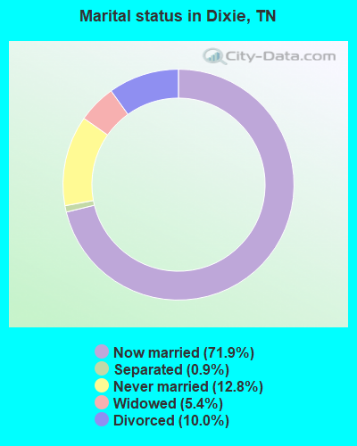
- Never married: 12.8%
- Now married: 71.9%
- Separated: 0.9%
- Widowed: 5.4%
- Divorced: 10.0%
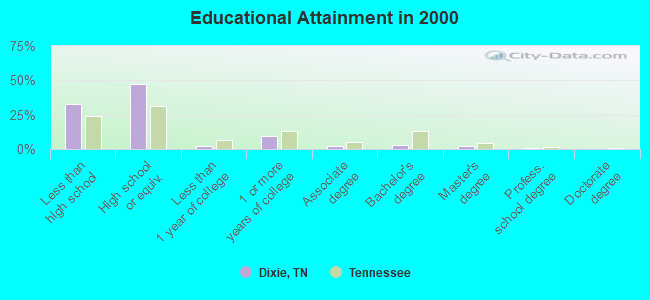
For population 25 years and over in Dixie:
- High school or higher: 67.0%
- Bachelor's degree or higher: 5.3%
- Graduate or professional degree: 2.4%
- Unemployed: 5.7%
- Mean travel time to work (commute): 23.2 minutes
| Here: | 10.4 |
| Tennessee average: | 13.3 |
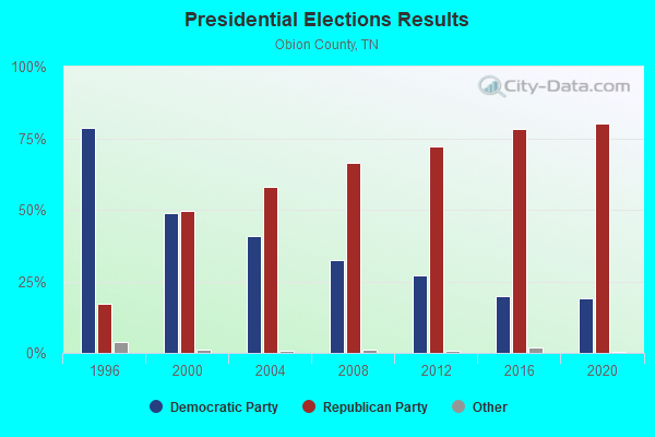
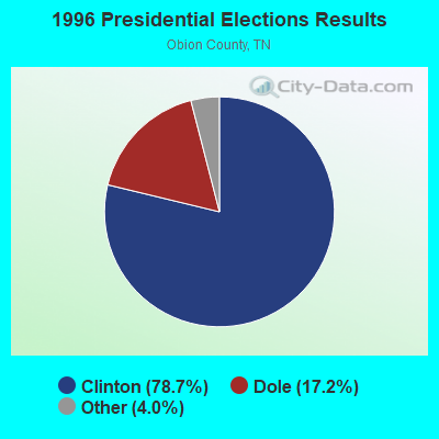
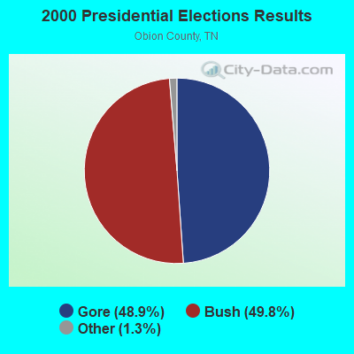
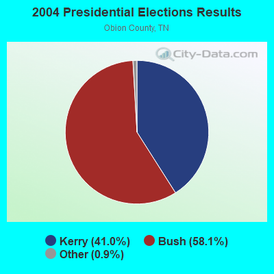
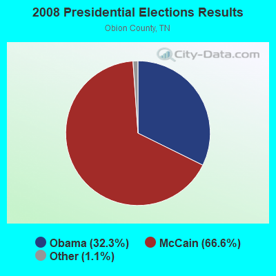
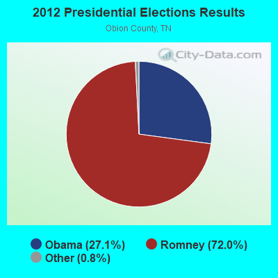
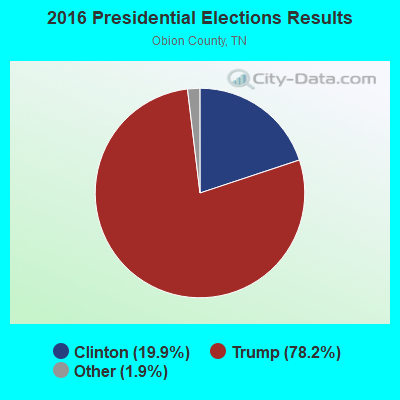
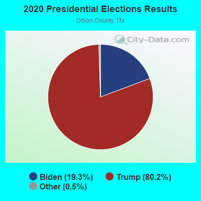
Graphs represent county-level data. Detailed 2008 Election Results
Religion statistics for Dixie, TN (based on Obion County data)
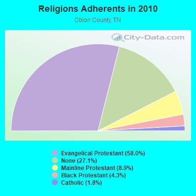
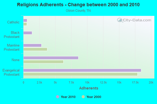
| Religion | Adherents | Congregations |
|---|---|---|
| Evangelical Protestant | 18,444 | 93 |
| Mainline Protestant | 2,845 | 25 |
| Black Protestant | 1,355 | 6 |
| Catholic | 558 | 1 |
| Other | - | 1 |
| None | 8,605 | - |
Food Environment Statistics:
| Here: | 1.59 / 10,000 pop. |
| Tennessee: | 1.99 / 10,000 pop. |
| Obion County: | 0.32 / 10,000 pop. |
| State: | 0.17 / 10,000 pop. |
| Here: | 0.32 / 10,000 pop. |
| State: | 0.65 / 10,000 pop. |
| Obion County: | 4.76 / 10,000 pop. |
| Tennessee: | 5.16 / 10,000 pop. |
| Obion County: | 7.94 / 10,000 pop. |
| Tennessee: | 6.56 / 10,000 pop. |
| Obion County: | 12.7% |
| State: | 11.4% |
| Obion County: | 30.9% |
| State: | 30.2% |
| Obion County: | 15.1% |
| Tennessee: | 13.5% |
Strongest AM radio stations in Dixie:
- WENK (1240 AM; 1 kW; UNION CITY, TN; Owner: WENK OF UNION CITY, INC.)
- WCRV (640 AM; 50 kW; COLLIERVILLE, TN; Owner: BOTT BROADCASTING COMPANY/TENNESSEE)
- WDIA (1070 AM; 50 kW; MEMPHIS, TN; Owner: CLEAR CHANNEL BROADCASTING LICENSES, INC.)
- WGSF (1030 AM; 50 kW; MEMPHIS, TN; Owner: FLINN BROADCASTING CORPORATION)
- KOTC (830 AM; daytime; 10 kW; KENNETT, MO; Owner: EAGLE BLUFF ENTERPRISES)
- WMQM (1600 AM; 50 kW; LAKELAND, TN; Owner: WMQM, INC.)
- WSM (650 AM; 50 kW; NASHVILLE, TN; Owner: GAYLORD ENTERTAINMENT COMPANY)
- KRHW (1520 AM; 5 kW; SIKESTON, MO)
- WKDA (1200 AM; 50 kW; NASHVILLE, TN; Owner: RADIO NASHVILLE, INC.)
- WKZT (1270 AM; 1 kW; FULTON, KY; Owner: RIVER COUNTY BROADCASTING, INC.)
- WPAD (1560 AM; 10 kW; PADUCAH, KY; Owner: BRISTOL BROADCASTING COMPANY, INC.)
- WNQM (1300 AM; 50 kW; NASHVILLE, TN; Owner: WNQM. INC.)
- WAMB (1160 AM; 50 kW; DONELSON, TN; Owner: GREAT SOUTHERN BROADCASTING COMPANY, INC.)
Strongest FM radio stations in Dixie:
- WQAK (105.7 FM; UNION CITY, TN; Owner: TWIN STATES BROADCASTING, INC.)
- WASL (100.1 FM; DYERSBURG, TN; Owner: DR PEPPER PEPSI-COLA BOTTLING CO.)
- WYVY (104.9 FM; UNION CITY, TN; Owner: TWIN STATES BROADCASTING, INC.)
- WWKF (99.3 FM; FULTON, KY; Owner: WENK OF UNION CITY, INC.)
- WKNQ (90.7 FM; DYERSBURG, TN; Owner: MID-SOUTH PUBLIC COMMS. FOUNDATION)
- KTMO (106.5 FM; NEW MADRID, MO; Owner: POLLACK BROADCASTING CO.)
- W205BN (88.9 FM; DYERSBURG, TN; Owner: WAY-FM MEDIA GROUP, INC.)
- WCMT-FM (101.7 FM; MARTIN, TN; Owner: THUNDERBOLT BROADCASTING COMPANY)
- WLSQ-FM (94.3 FM; DYER, TN; Owner: F. DARRELL BOYD)
- W218BE (91.5 FM; UNION CITY, TN; Owner: WAY-FM MEDIA GROUP, INC)
- W299AN (107.7 FM; UNION CITY, TN; Owner: HEARTLAND MINISTRIES, INC.)
TV broadcast stations around Dixie:
- WUWT-CA (Channel 9; UNION CITY, TN; Owner: JOSEPH H. HARPOLE, SR.)
- WDKA (Channel 49; PADUCAH, KY; Owner: WDKA ACQUISITION CORPORATION)
- WPSD-TV (Channel 6; PADUCAH, KY; Owner: WPSD-TV, LLC)
- WDYR-CA (Channel 33; DYERSBURG, TN; Owner: TRI-STATE CHRISTIAN TV, INC.)
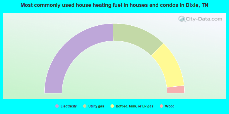
- 49.3%Electricity
- 25.3%Utility gas
- 21.9%Bottled, tank, or LP gas
- 3.5%Wood
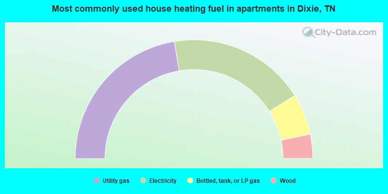
- 44.7%Utility gas
- 37.5%Electricity
- 11.2%Bottled, tank, or LP gas
- 6.6%Wood
Dixie compared to Tennessee state average:
- Median house value below state average.
- Unemployed percentage below state average.
- Black race population percentage significantly below state average.
- Hispanic race population percentage significantly below state average.
- Foreign-born population percentage significantly below state average.
- Renting percentage significantly below state average.
- Length of stay since moving in significantly above state average.
- Number of rooms per house significantly below state average.
- House age significantly below state average.
- Institutionalized population percentage significantly above state average.
- Number of college students below state average.
- Percentage of population with a bachelor's degree or higher significantly below state average.