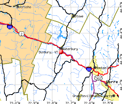
Duxbury, Vermont
Submit your own pictures of this town and show them to the world
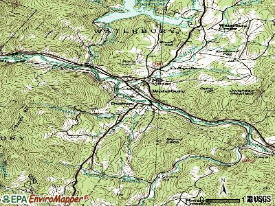
- OSM Map
- General Map
- Google Map
- MSN Map
Population change since 2000: +3.7%
 |
| Males: 676 | |
| Females: 661 |
| Median resident age: | 42.0 years |
| Vermont median age: | 45.8 years |
Zip codes: 05676.
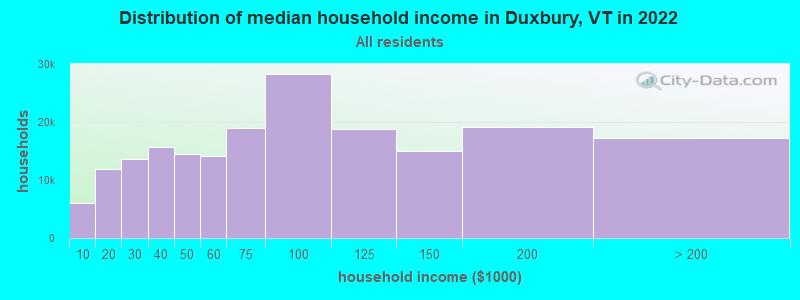
| Duxbury: | $90,470 |
| VT: | $73,991 |
Estimated per capita income in 2022: $42,753 (it was $20,707 in 2000)
Duxbury town income, earnings, and wages data
Estimated median house or condo value in 2022: $325,152 (it was $110,000 in 2000)
| Duxbury: | $325,152 |
| VT: | $304,700 |
Mean prices in 2022: all housing units: $350,068; detached houses: $366,162; townhouses or other attached units: $355,423; in 2-unit structures: $373,534; in 3-to-4-unit structures: $653,333; in 5-or-more-unit structures: $271,088; mobile homes: $98,551
Detailed information about poverty and poor residents in Duxbury, VT
Compare current foreclosures near Duxbury, VT:
| Photo | Address | Area | Beds / Baths | Price | Details |
|---|---|---|---|---|---|

|
#1
Bank St
Barre, VT 05641
|
1,485 sq. feet
|
2 baths 3 beds |
$299,900
|
show details |

|
#2
Elm St
Montpelier, VT 05602
|
- sq. feet
|
- baths - beds |
show details | |

|
#3
Elm St Apt 3
Montpelier, VT 05602
|
- sq. feet
|
- baths - beds |
show details | |

|
#4
Cedar Hill Ln Apt 30
Montpelier, VT 05602
|
- sq. feet
|
- baths - beds |
show details | |

|
#5
Rabbit Hollow Rd
Northfield, VT 05663
|
- sq. feet
|
- baths - beds |
show details | |

|
#6
Dugar Brook Rd
East Calais, VT 05650
|
- sq. feet
|
- baths - beds |
show details | |

|
#7
Ayers St Apt 4
Barre, VT 05641
|
- sq. feet
|
- baths - beds |
show details | |

|
#8
Stage Rd
Jericho, VT 05465
|
- sq. feet
|
- baths - beds |
show details | |

|
#9
Lazy Brook Dr
Starksboro, VT 05487
|
- sq. feet
|
- baths - beds |
show details | |

|
#10
Esplanade
Richmond, VT 05477
|
- sq. feet
|
- baths - beds |
show details |
| Photo | Address | Area | Beds / Baths | Price | Details |
|---|---|---|---|---|---|

|
#11
Terrace Dr
Northfield, VT 05663
|
- sq. feet
|
- baths - beds |
show details | |

|
#12
Vt Rte 214
Plainfield, VT 05667
|
- sq. feet
|
- baths - beds |
show details | |

|
#13
Vt Route 15
Jericho, VT 05465
|
- sq. feet
|
- baths - beds |
show details | |

|
#14
Willowbrook Ln
Williston, VT 05495
|
- sq. feet
|
- baths - beds |
show details | |

|
Check over 1 million property listings on Foreclosure.com!
|
browse all offers | |||

- 1,28596.1%White alone
- 231.7%Two or more races
- 141.0%Hispanic
- 90.7%Asian alone
- 50.4%Black alone
- 10.07%Other race alone
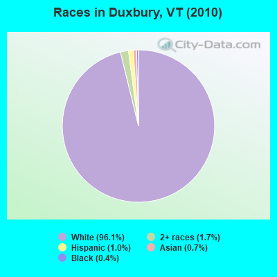
Races in Duxbury detailed stats: ancestries, foreign born residents, place of birth
According to our research of Vermont and other state lists, there were 3 registered sex offenders living in Duxbury, Vermont as of April 16, 2024.
The ratio of all residents to sex offenders in Duxbury is 446 to 1.
The ratio of registered sex offenders to all residents in this city is near the state average.
 Recent articles from our blog. Our writers, many of them Ph.D. graduates or candidates, create easy-to-read articles on a wide variety of topics.

 | Tell me about Duxbury (4 replies) |
| Mad River Valley? Questions on possible relocation... (30 replies) |
| Reasonable commute to Montpelier.... (6 replies) |
| Family Dollar store opening Duxbury/Moretown? (4 replies) |
| Rethinking Vermont- Cost of Living? (46 replies) |
| Property Subdivision/New Build Info? (7 replies) |
Latest news from Duxbury, VT collected exclusively by city-data.com from local newspapers, TV, and radio stations
Ancestries: Irish (15.4%), English (14.3%), United States (11.6%), French (10.2%), French Canadian (8.2%), German (8.1%).
Current Local Time: EST time zone
Elevation: 420 feet
Land area: 42.9 square miles.
Population density: 31 people per square mile (very low).
34 residents are foreign born (1.4% North America, 0.5% Africa, 0.4% Asia, 0.3% Europe).
| This town: | 2.6% |
| Vermont: | 3.8% |
| Duxbury town: | 1.9% ($2,124) |
| Vermont: | 2.0% ($2,196) |
Nearest city with pop. 50,000+: Manchester, NH  (113.1 miles , pop. 107,006).
Nearest city with pop. 200,000+: Boston, MA (161.7 miles , pop. 589,141).
Nearest city with pop. 1,000,000+: Bronx, NY (246.2 miles , pop. 1,332,650).
Nearest cities:
), ), ), Latitude: 44.31 N, Longitude: 72.77 W
Area code commonly used in this area: 802

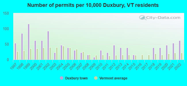
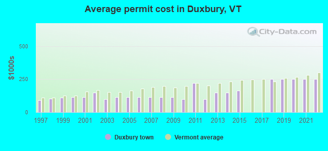
Single-family new house construction building permits:
- 2022: 8 buildings, average cost: $249,800
- 2021: 7 buildings, average cost: $249,800
- 2020: 6 buildings, average cost: $249,800
- 2019: 5 buildings, average cost: $249,800
- 2018: 5 buildings, average cost: $249,800
- 2015: 2 buildings, average cost: $162,500
- 2014: 5 buildings, average cost: $150,000
- 2013: 5 buildings, average cost: $150,000
- 2012: 6 buildings, average cost: $100,000
- 2011: 3 buildings, average cost: $220,300
- 2010: 4 buildings, average cost: $100,000
- 2009: 1 building, cost: $115,300
- 2008: 2 buildings, average cost: $115,300
- 2007: 3 buildings, average cost: $115,300
- 2006: 4 buildings, average cost: $115,300
- 2005: 5 buildings, average cost: $115,300
- 2004: 6 buildings, average cost: $115,300
- 2003: 3 buildings, average cost: $98,000
- 2002: 12 buildings, average cost: $150,000
- 2001: 8 buildings, average cost: $116,400
- 2000: 8 buildings, average cost: $114,700
- 1999: 15 buildings, average cost: $109,200
- 1998: 11 buildings, average cost: $101,700
- 1997: 7 buildings, average cost: $91,700
| Here: | 2.2% |
| Vermont: | 2.0% |
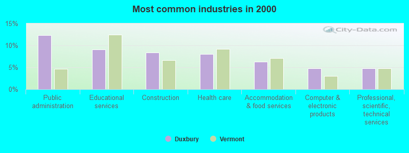
- Public administration (12.3%)
- Educational services (9.1%)
- Construction (8.4%)
- Health care (8.0%)
- Accommodation & food services (6.3%)
- Computer & electronic products (4.8%)
- Professional, scientific, technical services (4.8%)
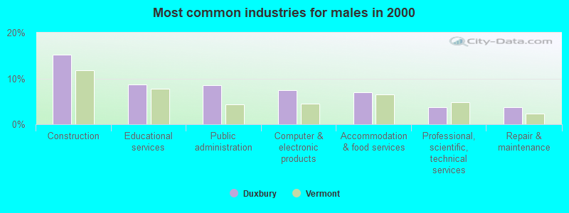
- Construction (15.2%)
- Educational services (8.8%)
- Public administration (8.5%)
- Computer & electronic products (7.5%)
- Accommodation & food services (7.0%)
- Professional, scientific, technical services (3.8%)
- Repair & maintenance (3.8%)
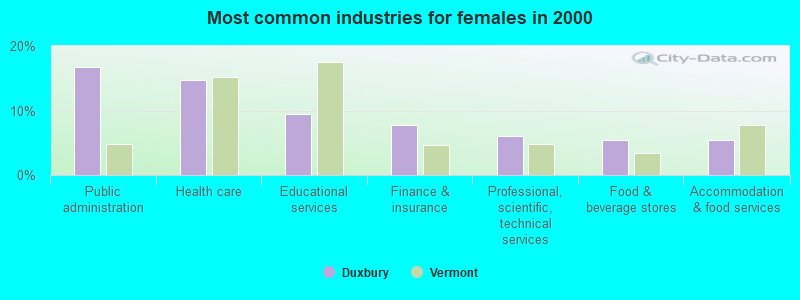
- Public administration (16.7%)
- Health care (14.7%)
- Educational services (9.5%)
- Finance & insurance (7.8%)
- Professional, scientific, technical services (6.0%)
- Food & beverage stores (5.5%)
- Accommodation & food services (5.5%)
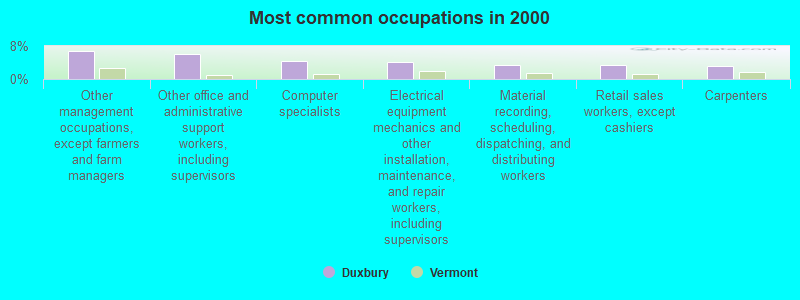
- Other management occupations, except farmers and farm managers (6.8%)
- Other office and administrative support workers, including supervisors (6.1%)
- Computer specialists (4.4%)
- Electrical equipment mechanics and other installation, maintenance, and repair workers, including supervisors (4.1%)
- Material recording, scheduling, dispatching, and distributing workers (3.5%)
- Retail sales workers, except cashiers (3.5%)
- Carpenters (3.1%)
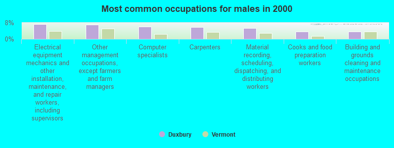
- Electrical equipment mechanics and other installation, maintenance, and repair workers, including supervisors (7.2%)
- Other management occupations, except farmers and farm managers (7.0%)
- Computer specialists (6.0%)
- Carpenters (5.8%)
- Material recording, scheduling, dispatching, and distributing workers (5.2%)
- Cooks and food preparation workers (3.8%)
- Building and grounds cleaning and maintenance occupations (3.8%)
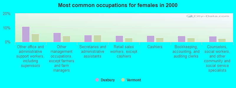
- Other office and administrative support workers, including supervisors (10.9%)
- Other management occupations, except farmers and farm managers (6.6%)
- Secretaries and administrative assistants (4.9%)
- Retail sales workers, except cashiers (4.6%)
- Cashiers (4.6%)
- Bookkeeping, accounting, and auditing clerks (4.3%)
- Counselors, social workers, and other community and social service specialists (4.0%)
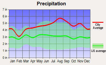
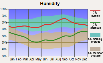
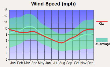
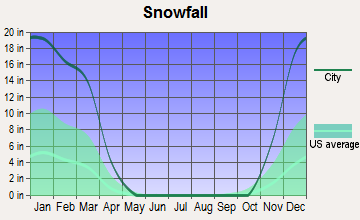
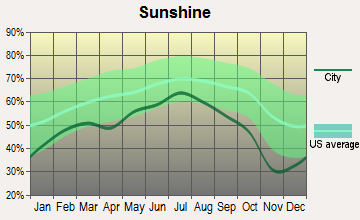
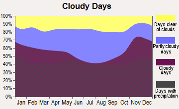
Average climate in Duxbury, Vermont
Based on data reported by over 4,000 weather stations

(lower is better)
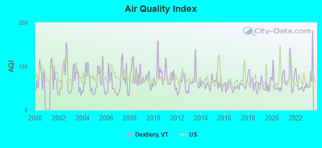
Air Quality Index (AQI) level in 2022 was 56.4. This is better than average.
| City: | 56.4 |
| U.S.: | 72.6 |
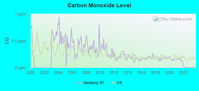
Carbon Monoxide (CO) [ppm] level in 2022 was 0.00585. This is significantly better than average. Closest monitor was 15.6 miles away from the city center.
| City: | 0.00585 |
| U.S.: | 0.25132 |
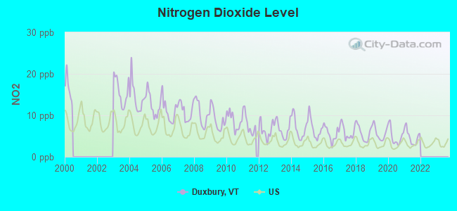
Nitrogen Dioxide (NO2) [ppb] level in 2021 was 4.81. This is about average. Closest monitor was 24.4 miles away from the city center.
| City: | 4.81 |
| U.S.: | 5.11 |
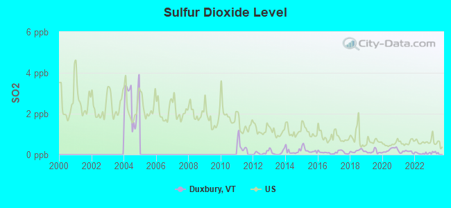
Sulfur Dioxide (SO2) [ppb] level in 2022 was 0.0619. This is significantly better than average. Closest monitor was 15.4 miles away from the city center.
| City: | 0.0619 |
| U.S.: | 1.5147 |
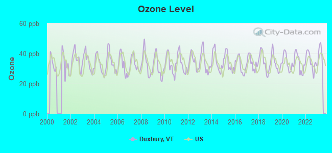
Ozone [ppb] level in 2022 was 34.8. This is about average. Closest monitor was 15.6 miles away from the city center.
| City: | 34.8 |
| U.S.: | 33.3 |
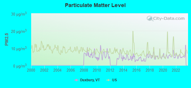
Particulate Matter (PM2.5) [µg/m3] level in 2022 was 5.26. This is significantly better than average. Closest monitor was 15.6 miles away from the city center.
| City: | 5.26 |
| U.S.: | 8.11 |
Earthquake activity:
Duxbury-area historical earthquake activity is significantly above Vermont state average. It is 71% smaller than the overall U.S. average.On 4/20/2002 at 10:50:47, a magnitude 5.3 (5.3 ML, Depth: 3.0 mi, Class: Moderate, Intensity: VI - VII) earthquake occurred 47.7 miles away from the city center
On 4/20/2002 at 10:50:47, a magnitude 5.2 (5.2 MB, 4.2 MS, 5.2 MW, 5.0 MW) earthquake occurred 48.2 miles away from the city center
On 10/7/1983 at 10:18:46, a magnitude 5.3 (5.1 MB, 5.3 LG, 5.1 ML) earthquake occurred 81.7 miles away from the city center
On 1/19/1982 at 00:14:42, a magnitude 4.7 (4.5 MB, 4.7 MD, 4.5 LG, Class: Light, Intensity: IV - V) earthquake occurred 81.1 miles away from Duxbury center
On 10/16/2012 at 23:12:25, a magnitude 4.7 (4.7 ML, Depth: 10.0 mi) earthquake occurred 116.5 miles away from Duxbury center
On 6/16/1995 at 12:13:11, a magnitude 3.8 (3.8 LG, Depth: 3.1 mi, Class: Light, Intensity: II - III) earthquake occurred 42.6 miles away from Duxbury center
Magnitude types: regional Lg-wave magnitude (LG), body-wave magnitude (MB), duration magnitude (MD), local magnitude (ML), surface-wave magnitude (MS), moment magnitude (MW)
Natural disasters:
The number of natural disasters in Washington County (26) is a lot greater than the US average (15).Major Disasters (Presidential) Declared: 20
Emergencies Declared: 1
Causes of natural disasters: Floods: 21, Storms: 18, Heavy Rains: 2, Tropical Storms: 2, Winds: 2, Hurricane: 1, Landslide: 1, Winter Storm: 1, Other: 1 (Note: some incidents may be assigned to more than one category).
Hospitals and medical centers near Duxbury:
- VERMONT STATE HOSP (Hospital, about 2 miles away; WATERBURY, VT)
- VERMONT STATE HOSP DISTINCT PART UNIT (Hospital, about 2 miles away; WATERBURY, VT)
- VERMONT STATE NURSING HOME (Nursing Home, about 2 miles away; WATERBURY, VT)
- CENTRAL VERMONT HOME HEALTH AND HOSPICE (Home Health Center, about 13 miles away; BARRE, VT)
- MAYO HEALTHCARE INC. (Nursing Home, about 13 miles away; NORTHFIELD, VT)
- BERLIN HEALTH AND REHAB CTR (Nursing Home, about 13 miles away; BARRE, VT)
- ROWAN COURT HEALTH AND REHAB (Nursing Home, about 15 miles away; BARRE, VT)
Amtrak stations near Duxbury:
- 2 miles: WATERBURY-STOWE (WATERBURY, PARK ROW) . Services: enclosed waiting area, public restrooms, public payphones, free short-term parking, free long-term parking, call for car rental service, call for taxi service, intercity bus service.
- 10 miles: MONTPELIER-BARRE (MONTPELIER, MONTPELIER JCT. RD.) . Services: enclosed waiting area, public restrooms, public payphones, free short-term parking, free long-term parking, call for car rental service, call for taxi service.
Colleges/universities with over 2000 students nearest to Duxbury:
- Norwich University (about 14 miles; Northfield, VT; Full-time enrollment: 4,221)
- Saint Michael's College (about 23 miles; Colchester, VT; FT enrollment: 2,336)
- Community College of Vermont (about 24 miles; Winooski, VT; FT enrollment: 3,394)
- University of Vermont (about 24 miles; Burlington, VT; FT enrollment: 11,566)
- Champlain College (about 24 miles; Burlington, VT; FT enrollment: 2,623)
- Middlebury College (about 29 miles; Middlebury, VT; FT enrollment: 3,077)
- SUNY College at Plattsburgh (about 44 miles; Plattsburgh, NY; FT enrollment: 5,934)
Points of interest:
Notable locations in Duxbury: Hump Brook Tent Platforms (A), Montclair Glen Camp (B), Montclair Glen Lodge (C), Monroe Ranger Cabin (D). Display/hide their locations on the map
Cemeteries: Phillips-Duxbury Hill Cemetery (1), Graves Cemetery (2), Crossett Hill Cemetery (3). Display/hide their locations on the map
Lake: Beaver Meadow (A). Display/hide its location on the map
Streams, rivers, and creeks: Ridley Brook (A), Crosset Brook (B). Display/hide their locations on the map
Park in Duxbury: Monroe State Park (1). Display/hide its location on the map
| This town: | 2.4 people |
| Vermont: | 2.3 people |
| This town: | 72.4% |
| Whole state: | 62.5% |
| This town: | 9.1% |
| Whole state: | 9.2% |
Likely homosexual households (counted as self-reported same-sex unmarried-partner households)
- Lesbian couples: 0.2% of all households
- Gay men: 0.7% of all households
| This town: | 5.0% |
| Whole state: | 9.4% |
| This town: | 2.3% |
| Whole state: | 3.6% |
For population 15 years and over in Duxbury:
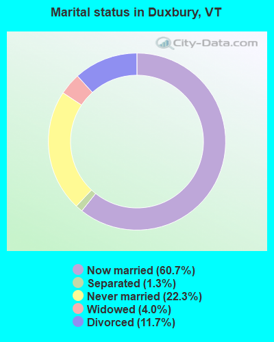
- Never married: 22.3%
- Now married: 60.7%
- Separated: 1.3%
- Widowed: 4.0%
- Divorced: 11.7%
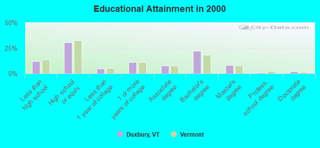
For population 25 years and over in Duxbury:
- High school or higher: 88.0%
- Bachelor's degree or higher: 33.1%
- Graduate or professional degree: 10.9%
- Unemployed: 7.0%
- Mean travel time to work (commute): 24.6 minutes
| Here: | 11.4 |
| Vermont average: | 11.7 |
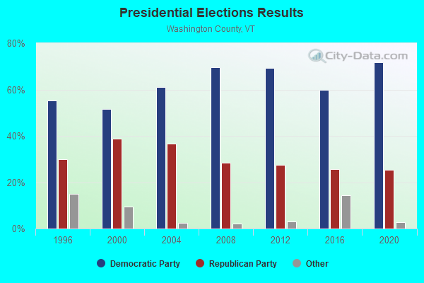
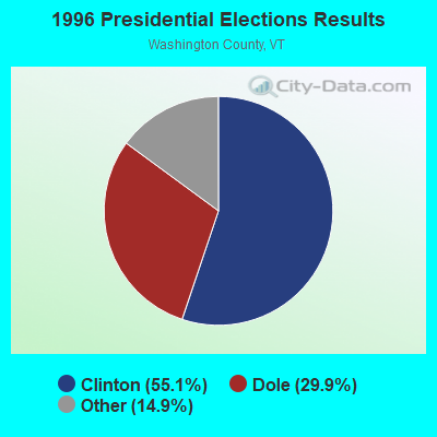
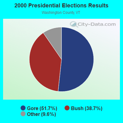
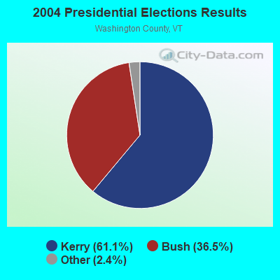
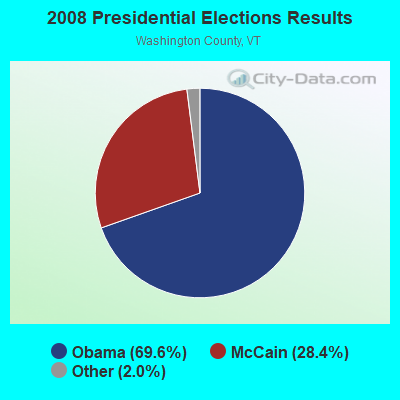
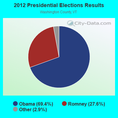
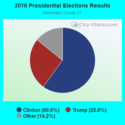
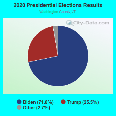
Graphs represent county-level data. Detailed 2008 Election Results
Religion statistics for Duxbury, VT (based on Washington County data)
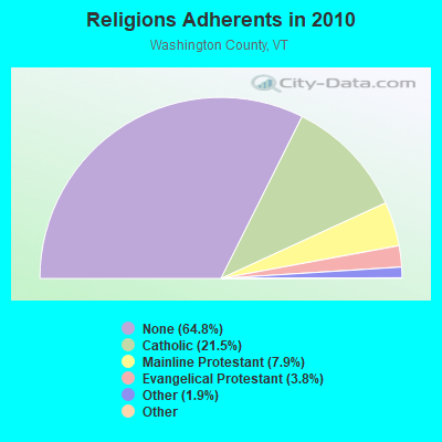
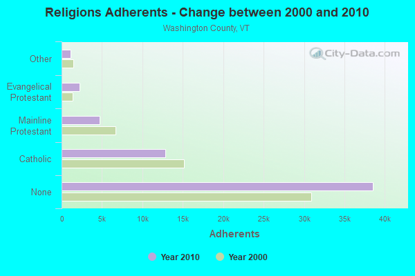
| Religion | Adherents | Congregations |
|---|---|---|
| Catholic | 12,800 | 9 |
| Mainline Protestant | 4,711 | 38 |
| Evangelical Protestant | 2,262 | 28 |
| Other | 1,125 | 12 |
| Orthodox | 50 | 1 |
| Black Protestant | 36 | 1 |
| None | 38,550 | - |
Food Environment Statistics:
| This county: | 4.25 / 10,000 pop. |
| Vermont: | 3.84 / 10,000 pop. |
| Here: | 3.06 / 10,000 pop. |
| State: | 1.95 / 10,000 pop. |
| This county: | 5.95 / 10,000 pop. |
| State: | 6.40 / 10,000 pop. |
| This county: | 11.04 / 10,000 pop. |
| State: | 11.52 / 10,000 pop. |
| Washington County: | 7.8% |
| Vermont: | 6.8% |
| This county: | 21.5% |
| Vermont: | 22.3% |
| Washington County: | 14.7% |
| State: | 13.3% |
Strongest AM radio stations in Duxbury:
- WDEV (550 AM; 5 kW; WATERBURY, VT; Owner: RADIO VERMONT, INC.)
- WCHP (760 AM; 35 kW; CHAMPLAIN, NY; Owner: CHAMPLAIN RADIO, INC.)
- WVMT (620 AM; 5 kW; BURLINGTON, VT; Owner: SISON BROADCASTING, INC.)
- WVAA (1390 AM; 5 kW; BURLINGTON, VT; Owner: RADIO VERMONT, KDR, LLC)
- WSKI (1240 AM; 1 kW; MONTPELIER, VT; Owner: GALLOWAY COMMUNICATIONS, INC.)
- WICY (1490 AM; 50 kW; MALONE, NY; Owner: CARTIER COMMUNICATIONS INC.)
- WGY (810 AM; 50 kW; SCHENECTADY, NY; Owner: CLEAR CHANNEL BROADCASTING LICENSES, INC.)
- WEAV (960 AM; 5 kW; PLATTSBURGH, NY; Owner: CLEAR CHANNEL BROADCASTING LICENSES, INC.)
- WNNZ (640 AM; 50 kW; WESTFIELD, MA; Owner: CLEAR CHANNEL BROADCASTING LICENSES, INC.)
- WTWN (1100 AM; daytime; 5 kW; WELLS RIVER, VT; Owner: PUFFER BROADCASTING, INC.)
- WRKO (680 AM; 50 kW; BOSTON, MA; Owner: ENTERCOM BOSTON LICENSE, LLC)
- WTWK (1070 AM; daytime; 5 kW; PLATTSBURGH, NY; Owner: CHAMPLAIN COMMUNICATIONS CORPORATION)
- WSNO (1450 AM; 1 kW; BARRE, VT; Owner: VOX VERMONT, L.L.C)
Strongest FM radio stations in Duxbury:
- WCVT (101.7 FM; STOWE, VT; Owner: RADIO VERMONT CLASSICS, L.L.C.)
- WNCS (104.7 FM; MONTPELIER, VT; Owner: MONTPELIER BROADCASTING, INC.)
- WVPS (107.9 FM; BURLINGTON, VT; Owner: VERMONT PUBLIC RADIO)
- WEZF (92.9 FM; BURLINGTON, VT; Owner: CAPSTAR TX LIMITED PARTNERSHIP)
- WLKC (103.3 FM; WATERBURY, VT; Owner: RADIO BROADCASTING SERVICES, INC.)
- WDEV-FM (96.1 FM; WARREN, VT; Owner: RADIO VERMONT, INC.)
- WGLY-FM (91.5 FM; BOLTON, VT; Owner: CHRISTIAN MINISTRIES, INC.)
- WEBK (105.3 FM; KILLINGTON, VT; Owner: 6 JOHNSON ROAD LICENSES, INC.)
- WJJR (98.1 FM; RUTLAND, VT; Owner: 6 JOHNSON ROAD LICENSES, INC.)
- WZRT (97.1 FM; RUTLAND, VT; Owner: CAPSTAR TX LIMITED PARTNERSHIP)
- WDOT (95.7 FM; DANVILLE, VT; Owner: MONTPELIER BROADCASTING INC)
- WGLV (91.7 FM; WOODSTOCK, VT; Owner: CHRISTIAN MINISTRIES INC)
- WHDQ-FM1 (106.1 FM; RUTLAND, VT; Owner: GREAT NORTHERN RADIO, L.L.C.)
- WPKQ (103.7 FM; NORTH CONWAY, NH; Owner: CITADEL BROADCASTING COMPANY)
- WHOM (94.9 FM; MT. WASHINGTON, NH; Owner: CITADEL BROADCASTING COMPANY)
- WCPV (101.3 FM; ESSEX, NY; Owner: CAPSTAR TX LIMITED PARTNERSHIP)
- WIZN (106.7 FM; VERGENNES, VT; Owner: BURLINGTON BROADCASTERS, INC.)
- WXZO (96.7 FM; WILLSBORO, NY; Owner: CAPSTAR TX LIMITED PARTNERSHIP)
- WGMT (97.7 FM; LYNDON, VT; Owner: VERMONT BROADCAST ASSOCIATES, INC.)
- WCEL (91.9 FM; PLATTSBURGH, NY; Owner: WAMC)
TV broadcast stations around Duxbury:
- WVNY (Channel 22; BURLINGTON, VT; Owner: C-22 FCC LICENSEE SUBSIDIARY, LLC)
- W19BR (Channel 19; MONKTON, VT; Owner: PLATTSBURGH PARTNERS)
- WCAX-TV (Channel 3; BURLINGTON, VT; Owner: MT. MANSFIELD TELEVISION, INC.)
- W54CV (Channel 54; BARRE, VT; Owner: NYN, LLC)
- W16AL (Channel 16; BURLINGTON, VT; Owner: TRINITY BROADCASTING NETWORK)
- Duxbury, Vermont
- Fatal accident count8
- Vehicles involved in fatal accidents12
- Fatal accidents involving drunk persons:3
- Fatalities8
- Persons involved in fatal accidents16
- Pedestrians involved in fatal accidents0
- Vermont average
- Fatal accident count792
- Vehicles involved in fatal accidents1060
- Fatal accidents involving drunk persons377
- Fatalities919
- Persons involved in fatal accidents2019
- Pedestrians involved in fatal accidents26
- National Bridge Inventory (NBI) Statistics
- 10Number of bridges
- 49ft / 14.8mTotal length
- $2,429,000Total costs
- 13,360Total average daily traffic
- 883Total average daily truck traffic
- 14,030Total future (year 2028) average daily traffic
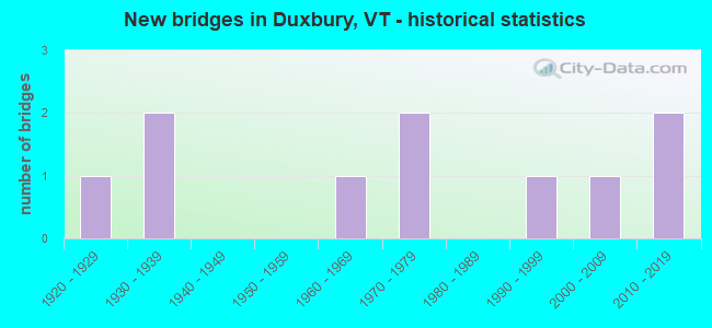
- New bridges - historical statistics
- 11920-1929
- 21930-1939
- 11960-1969
- 21970-1979
- 11990-1999
- 12000-2009
- 22010-2019
FCC Registered Broadcast Land Mobile Towers:
1- Turnerhill Rd 3/10 Mi W Of Rt 100 Jct (Lat: 44.258389 Lon: -72.791222), Call Sign: KNEN275, Licensee ID: L00102154,
Assigned Frequencies: 154.515 MHz, Grant Date: 01/16/1998, Expiration Date: 01/12/2003, Cancellation Date: 04/13/2003, Registrant: Todd Seymour, Box 840 Rfd, Moretown, VT 05660
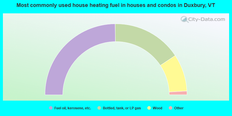
- 49.6%Fuel oil, kerosene, etc.
- 31.7%Bottled, tank, or LP gas
- 16.9%Wood
- 0.7%Coal or coke
- 0.5%Utility gas
- 0.5%Electricity
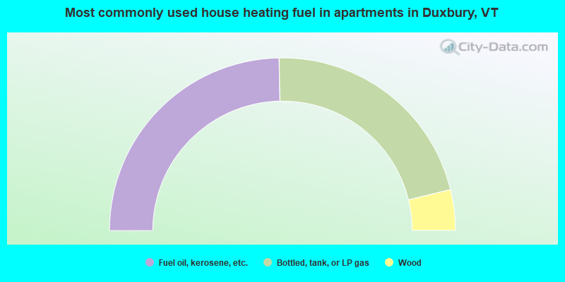
- 49.4%Fuel oil, kerosene, etc.
- 43.0%Bottled, tank, or LP gas
- 7.6%Wood
Duxbury compared to Vermont state average:
- Unemployed percentage below state average.
- Black race population percentage below state average.
- Hispanic race population percentage below state average.
- Foreign-born population percentage below state average.
- Renting percentage below state average.
- Length of stay since moving in significantly above state average.
- Number of rooms per house significantly below state average.
- House age significantly below state average.
Duxbury on our top lists:
- #14 on the list of "Top 101 cities with the largest percentage of people in homes for the mentally ill (population 1,000+)"
- #31 on the list of "Top 101 counties with the lowest average weight of females"
- #38 on the list of "Top 101 counties with the highest percentage of residents that smoked 100+ cigarettes in their lives"
- #48 on the list of "Top 101 counties with the highest percentage of residents that exercised in the past month"
- #53 on the list of "Top 101 counties with the highest percentage of residents that keep firearms around their homes"
- #58 on the list of "Top 101 counties with the best general health status score of residents (1-5), 3 years of data"

|
Total of 8 patent applications in 2008-2024.