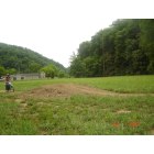
Flatgap, Kentucky
Submit your own pictures of this place and show them to the world
- OSM Map
- General Map
- Google Map
- MSN Map

| Males: 1,395 | |
| Females: 1,360 |
| Median resident age: | 37.5 years |
| Kentucky median age: | 35.9 years |
Zip code: 41219
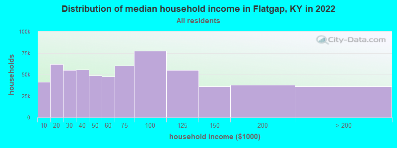
| Flatgap: | $39,829 |
| KY: | $59,341 |
Estimated per capita income in 2022: $21,318 (it was $12,884 in 2000)
Flatgap CCD income, earnings, and wages data
Estimated median house or condo value in 2022: $128,444 (it was $45,300 in 2000)
| Flatgap: | $128,444 |
| KY: | $196,300 |
Mean prices in 2022: all housing units: $182,946; detached houses: $219,470; townhouses or other attached units: $79,879; mobile homes: $69,598
Detailed information about poverty and poor residents in Flatgap, KY
Compare current foreclosures near Flatgap, KY:
| Photo | Address | Area | Beds / Baths | Price | Details |
|---|---|---|---|---|---|

|
#1
Ky Route 469
Flatgap, KY 41219
|
- sq. feet
|
- baths - beds |
show details | |

|
#2
Ky Route 3214
Flatgap, KY 41219
|
- sq. feet
|
- baths - beds |
show details | |

|
#3
Patterson Crk
Flatgap, KY 41219
|
- sq. feet
|
- baths - beds |
show details | |

|
#4
Patterson Crk
Flatgap, KY 41219
|
1,456 sq. feet
|
- baths - beds |
show details | |

|
#5
Ramey Br
Flatgap, KY 41219
|
- sq. feet
|
- baths - beds |
show details | |

|
#6
Stone Coal Rd
Flatgap, KY 41219
|
- sq. feet
|
- baths - beds |
show details | |

|
#7
Ross Br
Flatgap, KY 41219
|
- sq. feet
|
- baths - beds |
show details | |

|
#8
Blanton Dr
Staffordsville, KY 41256
|
1,086 sq. feet
|
2 baths 3 beds |
show details | |

|
#9
Kentucky Rte 3224
River, KY 41254
|
- sq. feet
|
- baths - beds |
$23,900
|
show details |

|
#10
Millers Crk
Van Lear, KY 41265
|
- sq. feet
|
2 baths 2 beds |
show details |
| Photo | Address | Area | Beds / Baths | Price | Details |
|---|---|---|---|---|---|

|
#11
Birch Branch Rd Unit 19
Salyersville, KY 41465
|
3,504 sq. feet
|
3 baths 4 beds |
show details | |

|
#12
Mazie Cir
Mazie, KY 41160
|
2,080 sq. feet
|
1 baths 3 beds |
show details | |

|
#13
Auxier Ave
Paintsville, KY 41240
|
1,722 sq. feet
|
1 baths 4 beds |
show details | |

|
#14
Highway 460 W
West Liberty, KY 41472
|
784 sq. feet
|
1 baths 2 beds |
show details | |

|
#15
Ky Route 201
Sitka, KY 41255
|
1,932 sq. feet
|
3 baths 5 beds |
show details | |

|
#16
Lyons Dr
Paintsville, KY 41240
|
2,296 sq. feet
|
2 baths 3 beds |
show details | |

|
#17
Dicey Frk
Meally, KY 41234
|
1,545 sq. feet
|
2 baths 3 beds |
show details | |

|
#18
Murray Dr
Sitka, KY 41255
|
864 sq. feet
|
1 baths 3 beds |
show details | |

|
#19
Ky Route 993
Paintsville, KY 41240
|
1,536 sq. feet
|
1 baths 3 beds |
show details | |

|
#20
Red Garden Ln
Louisa, KY 41230
|
1,600 sq. feet
|
1 baths 3 beds |
show details |
| Photo | Address | Area | Beds / Baths | Price | Details |
|---|---|---|---|---|---|

|
#21
Ky Route 40 W
Oil Springs, KY 41238
|
1,400 sq. feet
|
2 baths 3 beds |
show details | |

|
#22
Church Dr
Paintsville, KY 41240
|
2,352 sq. feet
|
2 baths 4 beds |
show details | |

|
#23
Buffalo Rd
Meally, KY 41234
|
1,672 sq. feet
|
2 baths 3 beds |
show details | |

|
#24
Sunny Ln
Hagerhill, KY 41222
|
- sq. feet
|
- baths - beds |
show details | |

|
#25
Millers Crk
Van Lear, KY 41265
|
- sq. feet
|
- baths - beds |
show details | |

|
#26
Industrial Park Lot 1
Hagerhill, KY 41222
|
- sq. feet
|
- baths - beds |
show details | |

|
#27
Bear Holw
East Point, KY 41216
|
- sq. feet
|
- baths - beds |
show details | |

|
#28
South Route 321
Hagerhill, KY 41222
|
- sq. feet
|
- baths - beds |
show details | |

|
#29
Beasley Branch Rd
Ulysses, KY 41264
|
- sq. feet
|
- baths - beds |
show details | |

|
#30
Delong Rd
Hagerhill, KY 41222
|
2,048 sq. feet
|
- baths - beds |
show details |
| Photo | Address | Area | Beds / Baths | Price | Details |
|---|---|---|---|---|---|

|
#31
Cow Branch Rd
West Liberty, KY 41472
|
- sq. feet
|
- baths - beds |
show details | |

|
#32
Goldenrod Ln
Vicco, KY 41773
|
- sq. feet
|
- baths - beds |
show details | |

|
#33
Highway 460 W
Salyersville, KY 41465
|
- sq. feet
|
- baths - beds |
show details | |

|
#34
Us Highway 23 S
East Point, KY 41216
|
- sq. feet
|
- baths - beds |
show details | |

|
#35
Mullins Hollow Rd
Sandy Hook, KY 41171
|
- sq. feet
|
- baths - beds |
show details | |

|
#36
Meades Branch Rd
Louisa, KY 41230
|
- sq. feet
|
- baths - beds |
show details | |

|
#37
Ranger Rd
Salyersville, KY 41465
|
- sq. feet
|
- baths - beds |
show details | |

|
#38
Green Acres Dr
Sandy Hook, KY 41171
|
- sq. feet
|
- baths - beds |
show details | |

|
#39
Auxier Ave
Auxier, KY 41602
|
- sq. feet
|
- baths - beds |
show details | |

|
#40
Gifford Rd
Salyersville, KY 41465
|
- sq. feet
|
- baths - beds |
show details |
| Photo | Address | Area | Beds / Baths | Price | Details |
|---|---|---|---|---|---|

|
#41
Johnson Fork Road
Salyersville, KY 41465
|
- sq. feet
|
- baths - beds |
show details | |

|
#42
Highway 1690
Louisa, KY 41230
|
- sq. feet
|
- baths - beds |
show details | |

|
#43
Kentucky Ave
Sandy Hook, KY 41171
|
- sq. feet
|
- baths - beds |
show details | |

|
#44
Burning Frk
Salyersville, KY 41465
|
- sq. feet
|
- baths - beds |
show details | |

|
#45
Royalton Rd
Salyersville, KY 41465
|
- sq. feet
|
- baths - beds |
show details | |

|
#46
Ky Route 40 E
Williamsport, KY 41271
|
1,972 sq. feet
|
- baths - beds |
show details | |

|
#47
Ky Route 1750 # 1750
East Point, KY 41216
|
- sq. feet
|
- baths - beds |
show details | |

|
#48
Storm Holw
East Point, KY 41216
|
- sq. feet
|
- baths - beds |
show details | |

|
#49
Richmond Hill Est
Van Lear, KY 41265
|
- sq. feet
|
- baths - beds |
show details | |

|
Check over 1 million property listings on Foreclosure.com!
|
browse all offers | |||

- 2,65698.7%White alone
- 130.5%Hispanic
- 110.4%Two or more races
- 40.1%Black alone
- 40.1%American Indian alone
- 30.1%Asian alone
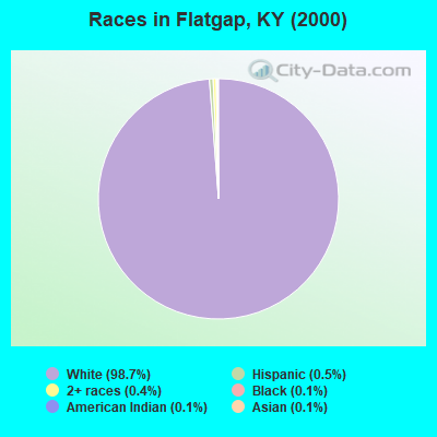
Races in Flatgap detailed stats: ancestries, foreign born residents, place of birth
According to our research of Kentucky and other state lists, there were 5 registered sex offenders living in Flatgap, Kentucky as of April 19, 2024.
The ratio of all residents to sex offenders in Flatgap is 551 to 1.
The ratio of registered sex offenders to all residents in this city is lower than the state average.
 Recent articles from our blog. Our writers, many of them Ph.D. graduates or candidates, create easy-to-read articles on a wide variety of topics.
Current Local Time: EST time zone
Elevation: 815 feet
Land area: 67.2 square miles.
Population density: 41 people per square mile (very low).
| Flatgap CCD: | 0.7% ($324) |
| Kentucky: | 0.8% ($610) |
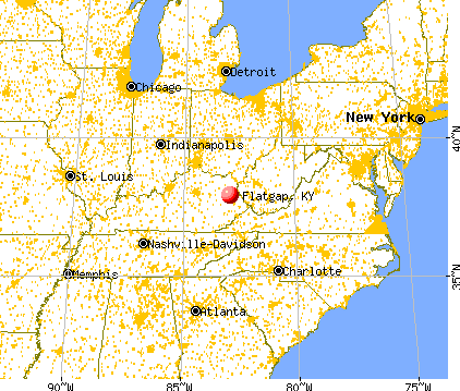
Nearest city with pop. 50,000+: Huntington, WV  (43.6 miles , pop. 51,475).
Nearest city with pop. 200,000+: Fayette, KY (85.1 miles , pop. 260,512).
Nearest city with pop. 1,000,000+: Chicago, IL (369.6 miles , pop. 2,896,016).
Nearest cities:
), ), ), ), ), )Latitude: 37.92 N, Longitude: 82.94 W
Area code commonly used in this area: 606

| Here: | 6.3% |
| Kentucky: | 3.8% |
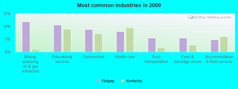
- Mining, quarrying, oil & gas extraction (11.9%)
- Educational services (10.6%)
- Construction (8.8%)
- Health care (8.1%)
- Truck transportation (5.5%)
- Food & beverage stores (5.5%)
- Accommodation & food services (4.8%)
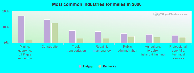
- Mining, quarrying, oil & gas extraction (17.3%)
- Construction (14.7%)
- Truck transportation (7.8%)
- Repair & maintenance (7.1%)
- Public administration (5.8%)
- Agriculture, forestry, fishing & hunting (5.3%)
- Professional, scientific, technical services (4.7%)

- Educational services (20.8%)
- Health care (16.1%)
- Department & other general merchandise stores (7.4%)
- Accommodation & food services (7.4%)
- Food & beverage stores (6.8%)
- Finance & insurance (6.0%)
- Radio, TV, computer stores (4.1%)

- Vehicle and mobile equipment mechanics, installers, and repairers (6.3%)
- Driver/sales workers and truck drivers (6.2%)
- Cashiers (4.9%)
- Electricians (4.0%)
- Financial clerks, except bookkeeping, accounting and auditing clerks (3.5%)
- Retail sales workers, except cashiers (3.3%)
- Other management occupations, except farmers and farm managers (3.2%)
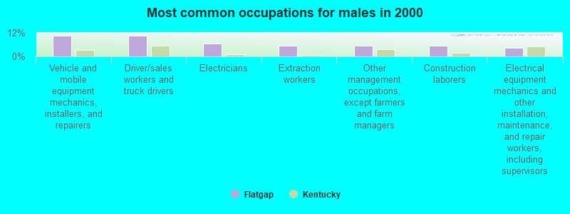
- Vehicle and mobile equipment mechanics, installers, and repairers (10.5%)
- Driver/sales workers and truck drivers (10.4%)
- Electricians (6.7%)
- Extraction workers (5.3%)
- Other management occupations, except farmers and farm managers (5.3%)
- Construction laborers (5.3%)
- Electrical equipment mechanics and other installation, maintenance, and repair workers, including supervisors (4.2%)

- Cashiers (12.3%)
- Financial clerks, except bookkeeping, accounting and auditing clerks (8.7%)
- Registered nurses (6.0%)
- Retail sales workers, except cashiers (6.0%)
- Customer service representatives (6.0%)
- Other teachers, instructors, education, training, and library occupations (5.7%)
- Secretaries and administrative assistants (5.7%)
Average climate in Flatgap, Kentucky
Based on data reported by over 4,000 weather stations


(lower is better)
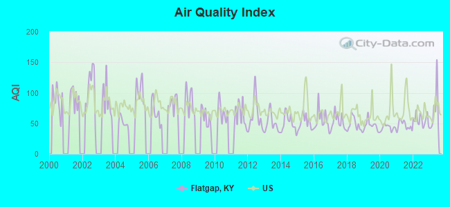
Air Quality Index (AQI) level in 2023 was 69.8. This is about average.
| City: | 69.8 |
| U.S.: | 72.6 |
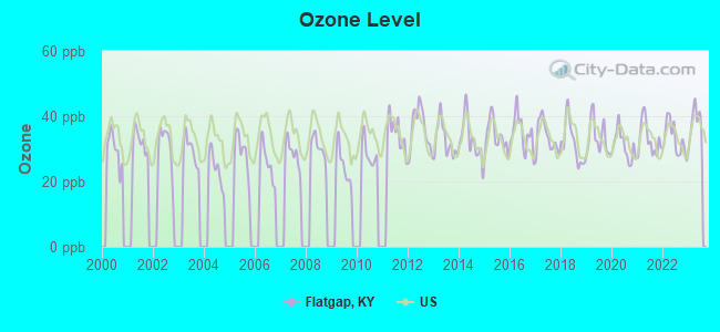
Ozone [ppb] level in 2023 was 38.0. This is about average. Closest monitor was 7.0 miles away from the city center.
| City: | 38.0 |
| U.S.: | 33.3 |
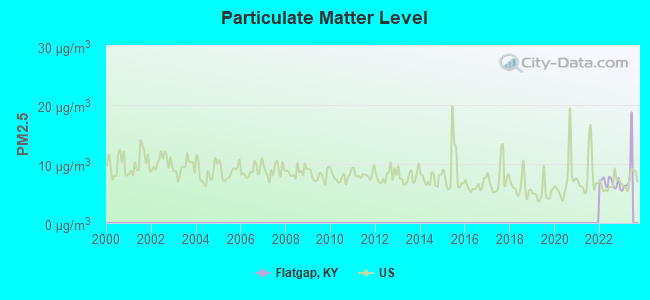
Particulate Matter (PM2.5) [µg/m3] level in 2022 was 6.85. This is about average. Closest monitor was 21.9 miles away from the city center.
| City: | 6.85 |
| U.S.: | 8.11 |
Tornado activity:
Flatgap-area historical tornado activity is significantly below Kentucky state average. It is 58% smaller than the overall U.S. average.
On 4/23/1968, a category F5 (max. wind speeds 261-318 mph) tornado 54.2 miles away from the Flatgap place center killed 7 people and injured 93 people and caused between $500,000 and $5,000,000 in damages.
On 4/8/1965, a category F3 (max. wind speeds 158-206 mph) tornado 34.6 miles away from the place center injured 3 people and caused between $50,000 and $500,000 in damages.
Earthquake activity:
Flatgap-area historical earthquake activity is significantly above Kentucky state average. It is 27% greater than the overall U.S. average.On 7/27/1980 at 18:52:21, a magnitude 5.2 (5.1 MB, 4.7 MS, 5.0 UK, 5.2 UK, Class: Moderate, Intensity: VI - VII) earthquake occurred 58.0 miles away from the city center
On 8/23/2011 at 17:51:04, a magnitude 5.8 (5.8 MW, Depth: 3.7 mi) earthquake occurred 272.9 miles away from the city center
On 8/9/2020 at 12:07:37, a magnitude 5.1 (5.1 MW, Depth: 4.7 mi) earthquake occurred 142.7 miles away from Flatgap center
On 9/7/1988 at 02:28:09, a magnitude 4.6 (4.5 MB, 4.6 LG, Class: Light, Intensity: IV - V) earthquake occurred 53.4 miles away from the city center
On 4/18/2008 at 09:36:59, a magnitude 5.4 (5.1 MB, 4.8 MS, 5.4 MW, 5.2 MW) earthquake occurred 271.4 miles away from the city center
On 11/23/2006 at 10:42:57, a magnitude 4.3 (4.3 MB) earthquake occurred 74.9 miles away from the city center
Magnitude types: regional Lg-wave magnitude (LG), body-wave magnitude (MB), surface-wave magnitude (MS), moment magnitude (MW)
Natural disasters:
The number of natural disasters in Johnson County (35) is a lot greater than the US average (15).Major Disasters (Presidential) Declared: 27
Emergencies Declared: 3
Causes of natural disasters: Floods: 24, Storms: 23, Mudslides: 9, Tornadoes: 9, Landslides: 7, Winter Storms: 6, Winds: 4, Fires: 2, Blizzard: 1, Freeze: 1, Hurricane: 1, Snow: 1, Snowfall: 1, Snowstorm: 1, Other: 1 (Note: some incidents may be assigned to more than one category).
Colleges/universities with over 2000 students nearest to Flatgap:
- Big Sandy Community and Technical College (about 19 miles; Prestonsburg, KY; Full-time enrollment: 2,660)
- Morehead State University (about 33 miles; Morehead, KY; FT enrollment: 7,523)
- Ashland Community and Technical College (about 41 miles; Ashland, KY; FT enrollment: 2,482)
- Marshall University (about 45 miles; Huntington, WV; FT enrollment: 11,450)
- Hazard Community and Technical College (about 50 miles; Hazard, KY; FT enrollment: 2,087)
- Shawnee State University (about 56 miles; Portsmouth, OH; FT enrollment: 4,160)
- Southeast Kentucky Community and Technical College (about 66 miles; Cumberland, KY; FT enrollment: 2,196)
Public elementary/middle school in Flatgap:
- FLAT GAP ELEMENTARY SCHOOL (Students: 288, Location: 1450 KY RT 689, Grades: PK-6)
Points of interest:
Notable locations in Flatgap: Flatgap Volunteer Fire Department (A), Red Bush Volunteer Fire Department Station 2 (B), Red Bush Volunteer Fire Department (C). Display/hide their locations on the map
Churches in Flatgap include: Low Gap United Baptist Church (A), Franks Creek Church (B), Old Little Paint Church (C), Oil Springs Church (D), Piegon Church (E), Old Bethel Church (F), Peaceful Valley Independent Baptist Church (G), Old Cold Springs United Baptist Church (H), Cold Springs Baptist Church (I). Display/hide their locations on the map
Cemeteries: Wheeler Cemetery (1), Whitehouse Cemetery (2), Salyers Cemetery (3), Sparks Cemetery (4). Display/hide their locations on the map
Streams, rivers, and creeks: Alum Dirt Branch (A), Andylick Branch (B), Barker Branch (C), Barnrock Branch (D), Beech Branch (E), Drakes Creek (F), Big Mine Fork (G), Biglick Branch (H), Blanton Branch (I). Display/hide their locations on the map
Park in Flatgap: Paintsville Lake Wildlife Area (1). Display/hide its location on the map
| This place: | 2.6 people |
| Kentucky: | 2.5 people |
| This place: | 74.4% |
| Whole state: | 66.9% |
| This place: | 4.7% |
| Whole state: | 6.4% |
Likely homosexual households (counted as self-reported same-sex unmarried-partner households)
- Lesbian couples: 0.5% of all households
- Gay men: 0.5% of all households
| This place: | 27.7% |
| Whole state: | 15.8% |
| This place: | 6.9% |
| Whole state: | 6.6% |
For population 15 years and over in Flatgap:
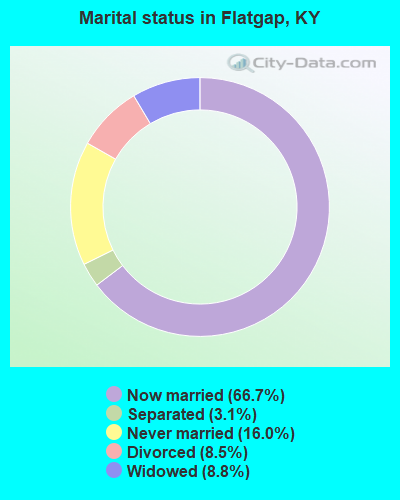
- Never married: 16.0%
- Now married: 66.7%
- Separated: 3.1%
- Widowed: 8.8%
- Divorced: 8.5%
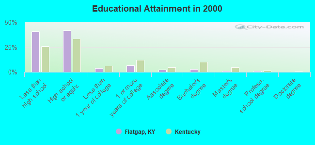
For population 25 years and over in Flatgap:
- High school or higher: 59.4%
- Bachelor's degree or higher: 4.5%
- Graduate or professional degree: 1.7%
- Unemployed: 11.3%
- Mean travel time to work (commute): 35.0 minutes

| Here: | 15.2 |
| Kentucky average: | 13.8 |
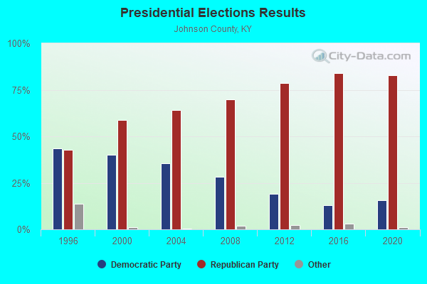
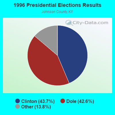
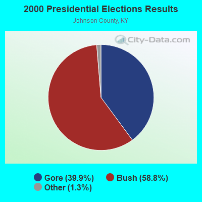

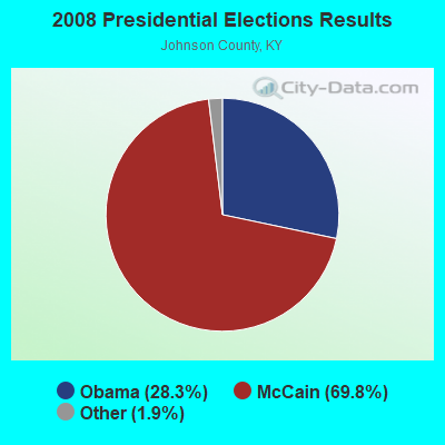

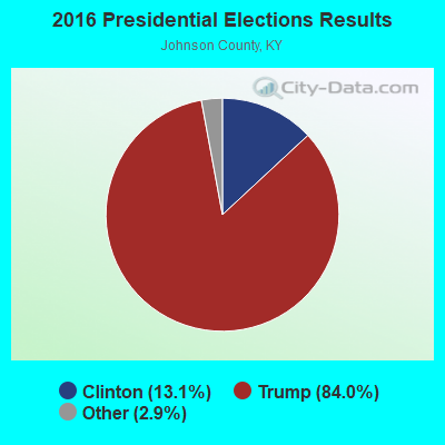

Graphs represent county-level data. Detailed 2008 Election Results
Religion statistics for Flatgap, KY (based on Johnson County data)
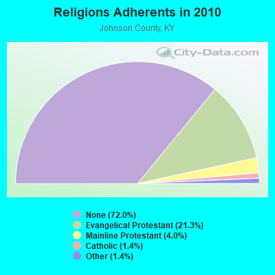
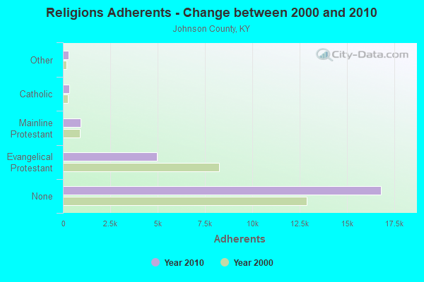
| Religion | Adherents | Congregations |
|---|---|---|
| Evangelical Protestant | 4,977 | 51 |
| Mainline Protestant | 925 | 4 |
| Catholic | 325 | 1 |
| Other | 316 | 2 |
| None | 16,813 | - |
Food Environment Statistics:
| Here: | 1.67 / 10,000 pop. |
| Kentucky: | 2.19 / 10,000 pop. |
| Johnson County: | 1.25 / 10,000 pop. |
| Kentucky: | 0.74 / 10,000 pop. |
| This county: | 5.42 / 10,000 pop. |
| Kentucky: | 4.36 / 10,000 pop. |
| Johnson County: | 5.00 / 10,000 pop. |
| Kentucky: | 5.74 / 10,000 pop. |
| This county: | 10.6% |
| Kentucky: | 11.0% |
| Johnson County: | 36.3% |
| State: | 30.0% |
| This county: | 19.6% |
| Kentucky: | 15.9% |
Strongest AM radio stations in Flatgap:
- WKYH (600 AM; 5 kW; PAINTSVILLE, KY; Owner: HIGHLANDS BROADCASTING CORPORATION)
- WPRT (960 AM; 5 kW; PRESTONSBURG, KY; Owner: EAST KENTUCKY RADIO NETWORK, INC.)
- WDOC (1310 AM; 5 kW; PRESTONSBURG, KY)
- WTVN (610 AM; 50 kW; COLUMBUS, OH; Owner: CITICASTERS LICENSES, L.P.)
- WMTC (730 AM; 5 kW; VANCLEVE, KY; Owner: THE KENTUCKY MOUNTAIN HOLINESS ASSN.)
- WEKG (810 AM; daytime; 5 kW; JACKSON, KY; Owner: INTERMOUNTAIN B/CING CO., INC.)
- WGOH (1370 AM; 5 kW; GRAYSON, KY; Owner: CARTER COUNTY BROADCASTING CO., INC.)
- WLW (700 AM; 50 kW; CINCINNATI, OH; Owner: JACOR BROADCASTING CORPORATION)
- WSIP (1490 AM; 1 kW; PAINTSVILLE, KY; Owner: S.I.P. BROADCASTING COMPANY, INC.)
- WRLV (1140 AM; daytime; 1 kW; SALYERSVILLE, KY; Owner: WALLINGFORD BROADCASTING COMPANY, INC)
- WVHU (800 AM; 5 kW; HUNTINGTON, WV; Owner: CAPSTAR TX LIMITED PARTNERSHIP)
- WLSI (900 AM; 5 kW; PIKEVILLE, KY; Owner: EAST KENTUCKY BROADCASTING CORPORATION)
- WRVC (930 AM; 5 kW; HUNTINGTON, WV; Owner: FIFTH AVENUE BROADCASTING COMPANY, INC.)
Strongest FM radio stations in Flatgap:
- WKLW-FM (94.7 FM; PAINTSVILLE, KY; Owner: B & G BROADCASTING, INC.)
- WSIP-FM (98.9 FM; PAINTSVILLE, KY; Owner: SIP BROADCASTING, INC.)
- WQHY (95.5 FM; PRESTONSBURG, KY; Owner: WDOC, INC.)
- WRLV-FM (106.5 FM; SALYERSVILLE, KY; Owner: WALLINGFORD BROADCASTING COMPANY, INC.)
- WMKY (90.3 FM; MOREHEAD, KY; Owner: MOREHEAD STATE UNIVERSITY)
- WXLR (104.9 FM; HAROLD, KY; Owner: ADAM D GEARHEART)
- WSGS (101.1 FM; HAZARD, KY; Owner: MOUNTAIN BROADCASTING SERVICE, INC.)
- WZQQ (97.9 FM; HYDEN, KY; Owner: LESLIE COUNTY BROADCASTING, INC.)
- WJSN-FM (106.5 FM; JACKSON, KY; Owner: INTERMOUNTAIN BROADCASTING CO.)
- WDHR (93.1 FM; PIKEVILLE, KY; Owner: EAST KENTUCKY BROADCASTING CORP.)
- WXKZ-FM (105.3 FM; PRESTONSBURG, KY; Owner: ADAM GEARHEART D/B/A WXLR-FM)
- WDGG (93.7 FM; ASHLAND, KY; Owner: FIFTH AVENUE B/CASTING COMPANY, INC.)
- WMDJ-FM (100.1 FM; ALLEN, KY; Owner: FLOYD COUNTY BROADCASTING CO., INC.)
- WBMK (88.5 FM; MOREHEAD, KY; Owner: AMERICAN FAMILY ASSOCIATION)
- WZAQ (92.3 FM; LOUISA, KY; Owner: LOUISA COMMUNICATIONS, INC.)
- WLKS-FM (102.9 FM; WEST LIBERTY, KY; Owner: MORGAN COUNTY INDUSTRIES, INC.)
TV broadcast stations around Flatgap:
- W26BK (Channel 26; TALBERT, KY; Owner: MS COMMUNICATIONS, LLC)
- WUPX-TV (Channel 67; MOREHEAD, KY; Owner: PAXSON LEXINGTON LICENSE, INC.)
- W16BI (Channel 16; TALBERT, KY; Owner: MS COMMUNICATIONS, LLC)
- WKMR (Channel 38; MOREHEAD, KY; Owner: KENTUCKY AUTHORITY FOR EDUCATIONAL TV)
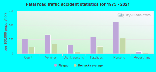
Flatgap fatal accident list:
Aug 17, 2008 03:30 AM, Sr-172, Lat: 37.865160, Lon: -82.863860, Vehicles: 1, Persons: 2, Pedestrians: 1, Fatalities: 1, Drunk persons involved: 1
Jun 2, 2007 06:15 PM, Sr-172, Lat: 37.846697, Lon: -82.858972, Vehicles: 2, Persons: 2, Fatalities: 1
Apr 2, 2005 09:44 PM, Sr-201, Lat: 37.920520, Lon: -82.830690, Vehicles: 1, Persons: 1, Fatalities: 1
Jul 4, 2005 07:15 PM, Sr-172, Lat: 37.910000, Lon: -82.889350, Vehicles: 1, Persons: 3, Fatalities: 1
Feb 20, 2004 08:30 PM, Franks Creek, Vehicles: 1, Persons: 2, Fatalities: 1, Drunk persons involved: 1
Mar 24, 1995 07:20 PM, 172, Vehicles: 2, Persons: 2, Fatalities: 2, Drunk persons involved: 1
FCC Registered Broadcast Land Mobile Towers:
1- MIXED FOREST TANK, Mixed Forest Tank - 0.26mi Ne Of Sr1092 & Fox Hunters Rdg Rd Junction (Lat: 37.958056 Lon: -82.925556), Type: Tank, Structure height: 15.2 m, Call Sign: WQGN735,
Assigned Frequencies: 173.312 MHz, Grant Date: 03/12/2007, Expiration Date: 03/12/2017, Cancellation Date: 05/13/2017, Certifier: Larry D Herald, Registrant: Micro-Comm, Inc., 15895 S. Pflumm Road, Olathe, KS 66062, Phone: (913) 390-4500, Fax: (913) 390-4550, Email:
FCC Registered Amateur Radio Licenses:
15 (See the full list of FCC Registered Amateur Radio Licenses in Flatgap)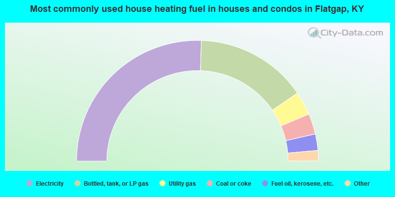
- 51.0%Electricity
- 29.9%Bottled, tank, or LP gas
- 6.3%Utility gas
- 5.5%Coal or coke
- 4.4%Fuel oil, kerosene, etc.
- 1.8%Other fuel
- 1.0%Wood
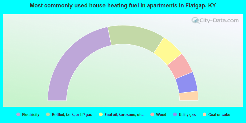
- 43.4%Electricity
- 24.8%Bottled, tank, or LP gas
- 10.3%Fuel oil, kerosene, etc.
- 9.0%Wood
- 8.3%Utility gas
- 4.1%Coal or coke
Flatgap compared to Kentucky state average:
- Median house value below state average.
- Black race population percentage significantly below state average.
- Hispanic race population percentage significantly below state average.
- Foreign-born population percentage significantly below state average.
- Renting percentage below state average.
- Length of stay since moving in significantly above state average.
- Number of rooms per house significantly below state average.
- House age significantly below state average.
- Number of college students below state average.
- Percentage of population with a bachelor's degree or higher significantly below state average.