Fleming, Missouri
Submit your own pictures of this city and show them to the world
Detailed information about poverty and poor residents in Fleming, MO
 Recent articles from our blog. Our writers, many of them Ph.D. graduates or candidates, create easy-to-read articles on a wide variety of topics.
| Here: | 2.8% |
| Missouri: | 2.8% |
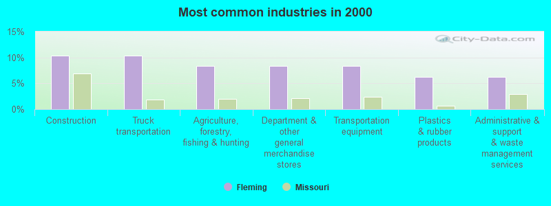
- Construction (10.4%)
- Truck transportation (10.4%)
- Agriculture, forestry, fishing & hunting (8.3%)
- Department & other general merchandise stores (8.3%)
- Transportation equipment (8.3%)
- Plastics & rubber products (6.2%)
- Administrative & support & waste management services (6.2%)
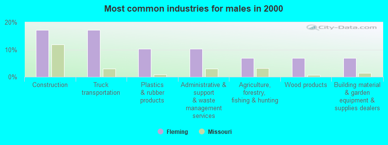
- Construction (17.2%)
- Truck transportation (17.2%)
- Plastics & rubber products (10.3%)
- Administrative & support & waste management services (10.3%)
- Agriculture, forestry, fishing & hunting (6.9%)
- Wood products (6.9%)
- Building material & garden equipment & supplies dealers (6.9%)
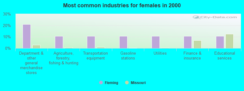
- Department & other general merchandise stores (21.1%)
- Agriculture, forestry, fishing & hunting (10.5%)
- Transportation equipment (10.5%)
- Gasoline stations (10.5%)
- Utilities (10.5%)
- Finance & insurance (10.5%)
- Educational services (10.5%)
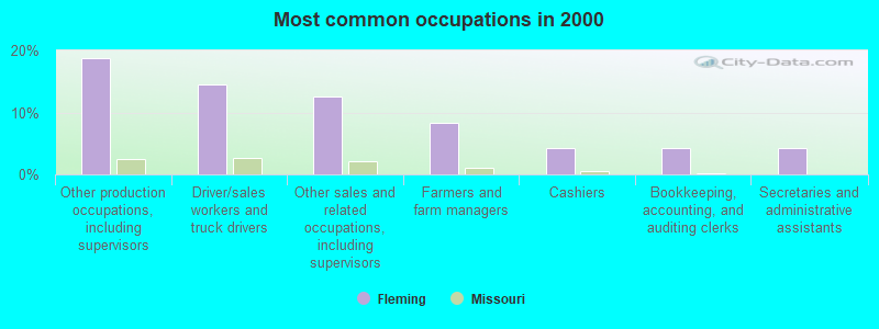
- Other production occupations, including supervisors (18.8%)
- Driver/sales workers and truck drivers (14.6%)
- Other sales and related occupations, including supervisors (12.5%)
- Farmers and farm managers (8.3%)
- Cashiers (4.2%)
- Bookkeeping, accounting, and auditing clerks (4.2%)
- Secretaries and administrative assistants (4.2%)
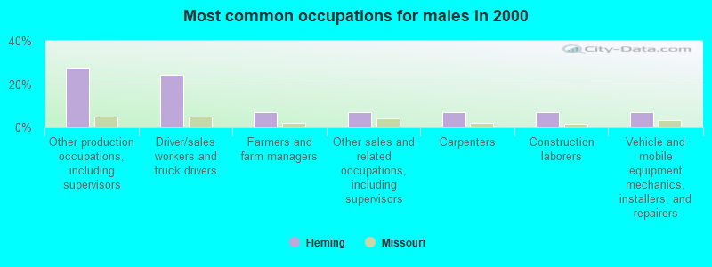
- Other production occupations, including supervisors (27.6%)
- Driver/sales workers and truck drivers (24.1%)
- Farmers and farm managers (6.9%)
- Other sales and related occupations, including supervisors (6.9%)
- Carpenters (6.9%)
- Construction laborers (6.9%)
- Vehicle and mobile equipment mechanics, installers, and repairers (6.9%)
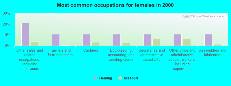
- Other sales and related occupations, including supervisors (21.1%)
- Farmers and farm managers (10.5%)
- Cashiers (10.5%)
- Bookkeeping, accounting, and auditing clerks (10.5%)
- Secretaries and administrative assistants (10.5%)
- Other office and administrative support workers, including supervisors (10.5%)
- Assemblers and fabricators (10.5%)
Average climate in Fleming, Missouri
Based on data reported by over 4,000 weather stations


(lower is better)
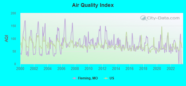
Air Quality Index (AQI) level in 2022 was 66.7. This is about average.
| City: | 66.7 |
| U.S.: | 72.6 |
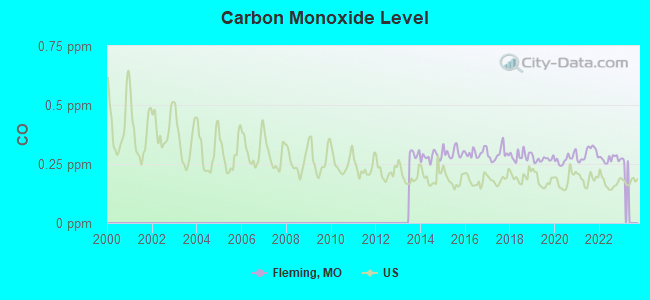
Carbon Monoxide (CO) [ppm] level in 2022 was 0.271. This is about average. Closest monitor was 22.2 miles away from the city center.
| City: | 0.271 |
| U.S.: | 0.251 |
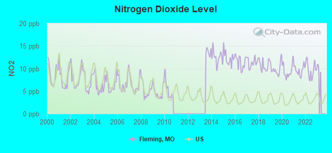
Nitrogen Dioxide (NO2) [ppb] level in 2022 was 9.75. This is significantly worse than average. Closest monitor was 19.0 miles away from the city center.
| City: | 9.75 |
| U.S.: | 5.11 |
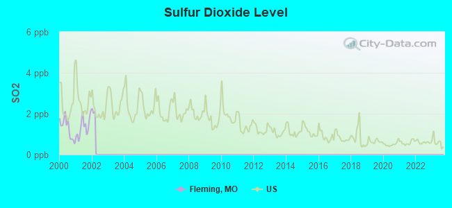
Sulfur Dioxide (SO2) [ppb] level in 2001 was 1.35. This is about average. Closest monitor was 20.9 miles away from the city center.
| City: | 1.35 |
| U.S.: | 1.51 |
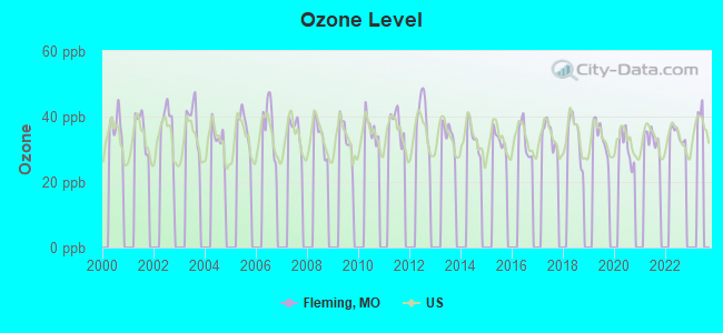
Ozone [ppb] level in 2022 was 34.6. This is about average. Closest monitor was 18.7 miles away from the city center.
| City: | 34.6 |
| U.S.: | 33.3 |
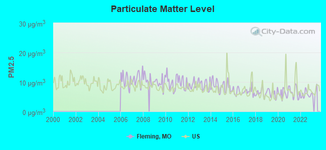
Particulate Matter (PM2.5) [µg/m3] level in 2022 was 5.66. This is significantly better than average. Closest monitor was 19.0 miles away from the city center.
| City: | 5.66 |
| U.S.: | 8.11 |
Tornado activity:
Fleming-area historical tornado activity is near Missouri state average. It is 77% greater than the overall U.S. average.
On 5/20/1957, a category F5 (max. wind speeds 261-318 mph) tornado 23.9 miles away from the Fleming city center killed 44 people and injured 207 people and caused between $500,000 and $5,000,000 in damages.
On 5/4/1977, a category F4 (max. wind speeds 207-260 mph) tornado 9.1 miles away from the city center injured one person and caused between $500,000 and $5,000,000 in damages.
Earthquake activity:
Fleming-area historical earthquake activity is significantly above Missouri state average. It is 461% greater than the overall U.S. average.On 9/3/2016 at 12:02:44, a magnitude 5.8 (5.8 MW, Depth: 3.5 mi, Class: Moderate, Intensity: VI - VII) earthquake occurred 247.8 miles away from the city center
On 11/6/2011 at 03:53:10, a magnitude 5.7 (5.7 MW, Depth: 3.2 mi) earthquake occurred 293.9 miles away from Fleming center
On 11/12/2014 at 21:40:00, a magnitude 4.9 (4.9 MW, Depth: 2.5 mi, Class: Light, Intensity: IV - V) earthquake occurred 235.1 miles away from the city center
On 4/18/2008 at 09:36:59, a magnitude 5.4 (5.1 MB, 4.8 MS, 5.4 MW, 5.2 MW) earthquake occurred 336.1 miles away from Fleming center
On 11/7/2016 at 01:44:24, a magnitude 5.0 (5.0 MW, Depth: 2.8 mi) earthquake occurred 268.0 miles away from the city center
On 9/26/1990 at 13:18:51, a magnitude 5.0 (4.7 MB, 4.8 LG, 5.0 LG, Depth: 7.7 mi) earthquake occurred 282.7 miles away from the city center
Magnitude types: regional Lg-wave magnitude (LG), body-wave magnitude (MB), surface-wave magnitude (MS), moment magnitude (MW)
Natural disasters:
The number of natural disasters in Ray County (31) is a lot greater than the US average (15).Major Disasters (Presidential) Declared: 22
Emergencies Declared: 6
Causes of natural disasters: Floods: 22, Storms: 19, Tornadoes: 12, Winter Storms: 4, Winds: 2, Drought: 1, Heavy Rain: 1, Hurricane: 1, Ice Storm: 1, Snowstorm: 1, Other: 1 (Note: some incidents may be assigned to more than one category).
Hospitals and medical centers near Fleming:
- FMC -LETHOLT DIALYSIS CENTER (Dialysis Facility, about 8 miles away; RICHMOND, MO)
- RAY COUNTY MEMORIAL HOSPITAL Critical Access Hospitals (about 8 miles away; RICHMOND, MO)
- SHIRKEY NURSING AND REHABILITATION CENTER (Nursing Home, about 8 miles away; RICHMOND, MO)
- LAFAYETTE REGIONAL HEALTH CENTER Critical Access Hospitals (about 10 miles away; LEXINGTON, MO)
- EXCELSIOR SPRINGS CITY HOSP AND CONV (Nursing Home, about 15 miles away; EXCELSIOR SPRINGS, MO)
- GOLDEN LIVINGCENTER-NEW HAVEN (Nursing Home, about 15 miles away; ODESSA, MO)
- NEW HAVEN NH (Nursing Home, about 15 miles away; ODESSA, MO)
Colleges/universities with over 2000 students nearest to Fleming:
- Rockhurst University (about 31 miles; Kansas City, MO; Full-time enrollment: 2,013)
- Metropolitan Community College-Kansas City (about 31 miles; Kansas City, MO; FT enrollment: 12,834)
- University of Missouri-Kansas City (about 31 miles; Kansas City, MO; FT enrollment: 10,544)
- Grantham University (about 34 miles; Kansas City, MO; FT enrollment: 8,385)
- Park University (about 34 miles; Parkville, MO; FT enrollment: 9,131)
- University of Central Missouri (about 35 miles; Warrensburg, MO; FT enrollment: 9,952)
- Kansas City Kansas Community College (about 38 miles; Kansas City, KS; FT enrollment: 4,718)
Points of interest:
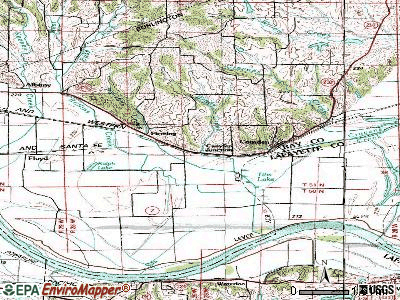
Cemetery: Smith - Jackson Cemetery (1). Display/hide its location on the map
| This city: | 2.5 people |
| Missouri: | 2.5 people |
| This city: | 78.4% |
| Whole state: | 65.3% |
| This city: | 3.9% |
| Whole state: | 6.7% |
No gay or lesbian households reported
| Here: | 9.6 |
| Missouri average: | 11.1 |
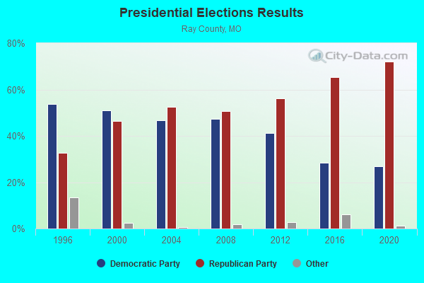
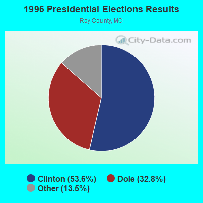
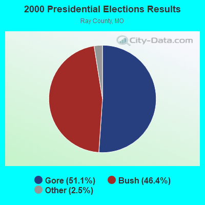
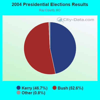
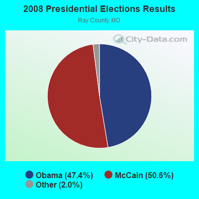
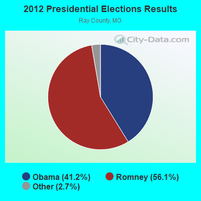
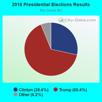
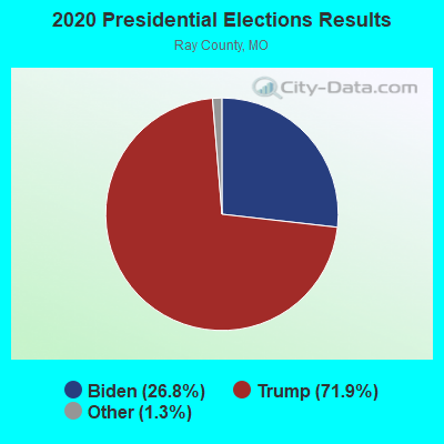
Graphs represent county-level data. Detailed 2008 Election Results
Religion statistics for Fleming, MO (based on Ray County data)
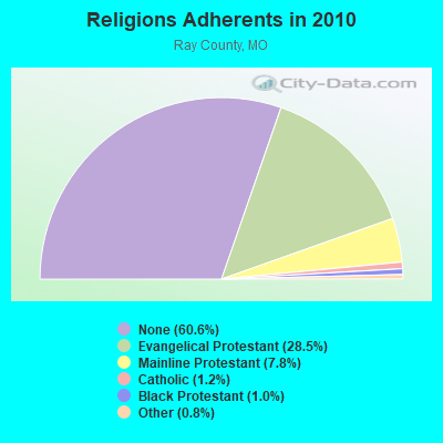
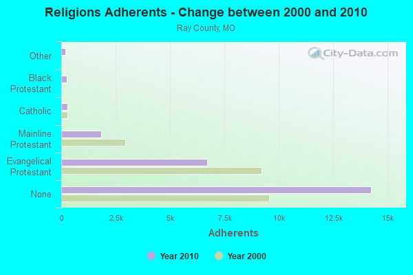
| Religion | Adherents | Congregations |
|---|---|---|
| Evangelical Protestant | 6,690 | 35 |
| Mainline Protestant | 1,839 | 13 |
| Catholic | 291 | 1 |
| Black Protestant | 246 | 2 |
| Other | 181 | 2 |
| None | 14,247 | - |
Food Environment Statistics:
| Ray County: | 1.28 / 10,000 pop. |
| Missouri: | 1.88 / 10,000 pop. |
| Ray County: | 0.43 / 10,000 pop. |
| Missouri: | 0.18 / 10,000 pop. |
| Ray County: | 5.97 / 10,000 pop. |
| Missouri: | 4.34 / 10,000 pop. |
| Ray County: | 4.69 / 10,000 pop. |
| State: | 7.37 / 10,000 pop. |
| Here: | 10.2% |
| Missouri: | 8.8% |
| This county: | 30.3% |
| Missouri: | 29.6% |
| Ray County: | 7.4% |
| Missouri: | 13.5% |
| Local government employment and payroll (March 2022) | |||||
| Function | Full-time employees | Monthly full-time payroll | Average yearly full-time wage | Part-time employees | Monthly part-time payroll |
|---|---|---|---|---|---|
| Police Protection - Officers | 0 | $0 | 1 | $1,242 | |
| Other Government Administration | 0 | $0 | 3 | $552 | |
| Judicial and Legal | 0 | $0 | 3 | $828 | |
| Totals for Government | 0 | $0 | 7 | $2,622 | |
Strongest AM radio stations in Fleming:
- WHB (810 AM; 50 kW; KANSAS CITY, MO; Owner: UNION BROADCASTING, INC.)
- KKHK (1250 AM; 25 kW; KANSAS CITY, KS)
- KCMO (710 AM; 10 kW; KANSAS CITY, MO; Owner: SUSQUEHANNA KANSAS CITY PARTNERSHIP)
- KCTE (1510 AM; daytime; 10 kW; INDEPENDENCE, MO; Owner: UNION BROADCASTING, INC.)
- KCCV (760 AM; daytime; 6 kW; OVERLAND PARK, KS; Owner: BOTT BROADCASTING COMPANY)
- KCSP (610 AM; 5 kW; KANSAS CITY, MO; Owner: ENTERCOM KANSAS CITY LICENSE, LLC)
- KPHN (1190 AM; 5 kW; KANSAS CITY, MO; Owner: ABC, INC.)
- KXTR (1660 AM; 10 kW; KANSAS CITY, KS; Owner: ENTERCOM KANSAS CITY LICENSE, LLC)
- KMBZ (980 AM; 5 kW; KANSAS CITY, MO; Owner: ENTERCOM KANSAS CITY LICENSE, LLC)
- KCWJ (1030 AM; 1 kW; BLUE SPRINGS, MO; Owner: CHRISTIAN BROADCASTING ASSOCIATES, LP)
- KEXS (1090 AM; daytime; 1 kW; EXCELSIOR SPRINGS, MO; Owner: JEFFCO TELEVISION CORP.)
- KGGN (890 AM; daytime; 1 kW; GLADSTONE, MO; Owner: MORTENSON BROADCASTING COMPANY, INC.)
- KFEQ (680 AM; 5 kW; ST. JOSEPH, MO; Owner: EAGLE RADIO, INC.)
Strongest FM radio stations in Fleming:
- KMJK (107.3 FM; LEXINGTON, MO; Owner: ALLUR-KANSAS CITY, INC.)
- KAYX (92.5 FM; RICHMOND, MO; Owner: BOTT COMMUNICATIONS, INC.)
- KSRC (102.1 FM; KANSAS CITY, MO; Owner: INFINITY RADIO OPERATIONS INC.)
- WDAF-FM (106.5 FM; LIBERTY, MO; Owner: ENTERCOM KANSAS CITY LICENSE, LLC)
- KUDL (98.1 FM; KANSAS CITY, KS; Owner: ENTERCOM KANSAS CITY LICENSE, LLC)
- KBEQ-FM (104.3 FM; KANSAS CITY, MO; Owner: INFINITY RADIO SUBSIDIARY OPERATIONS INC.)
- KQRC-FM (98.9 FM; LEAVENWORTH, KS; Owner: ENTERCOM KANSAS CITY LICENSE, LLC)
- KRBZ (96.5 FM; KANSAS CITY, MO; Owner: ENTERCOM KANSAS CITY LICENSE, LLC)
- KYYS (99.7 FM; KANSAS CITY, MO; Owner: ENTERCOM KANSAS CITY LICENSE, LLC)
- KMXV (93.3 FM; KANSAS CITY, MO; Owner: INFINITY RADIO OPERATIONS INC.)
- KZPL (97.3 FM; LEE'S SUMMIT, MO; Owner: UNION FIRST BROADCASTING, LLC)
- KCMO-FM (94.9 FM; KANSAS CITY, MO; Owner: SUSQUEHANNA KANSAS CITY PARTNERSHIP)
- KPRS (103.3 FM; KANSAS CITY, MO; Owner: CARTER BROADCAST GROUP, INC.)
- KCUR-FM (89.3 FM; KANSAS CITY, MO; Owner: CURATORS OF UNIVERSITY OF MISSOURI)
- KLJC (88.5 FM; KANSAS CITY, MO; Owner: CALVARY BIBLE COLLEGE)
- KCFX (101.1 FM; HARRISONVILLE, MO; Owner: SUSQUEHANNA KANSAS CITY PARTNERSHIP)
- KFKF-FM (94.1 FM; KANSAS CITY, KS; Owner: INFINITY RADIO SUBSIDIARY OPERATIONS INC.)
- KMZU (100.7 FM; CARROLLTON, MO; Owner: KANZA, INC.)
- KKFI (90.1 FM; KANSAS CITY, MO; Owner: MID-COAST RADIO PROJECT, INC.)
- KRLI (103.9 FM; MALTA BEND, MO; Owner: KANZA, INC.)
TV broadcast stations around Fleming:
- KMBC-TV (Channel 9; KANSAS CITY, MO; Owner: KMBC HEARST-ARGYLE TELEVISION, INC.)
- KCPT (Channel 19; KANSAS CITY, MO; Owner: PUBLIC TELEVISION 19, INC.)
- KSMO-TV (Channel 62; KANSAS CITY, MO; Owner: KSMO LICENSEE, INC.)
- KCTV (Channel 5; KANSAS CITY, MO; Owner: MEREDITH CORPORATION)
- KCWE (Channel 29; KANSAS CITY, MO; Owner: KCWE-TV, INC.)
- KPXE (Channel 50; KANSAS CITY, MO; Owner: PAXSON KANSAS CITY LICENSE, INC.)
- KMCI (Channel 38; LAWRENCE, KS; Owner: SCRIPPS HOWARD BROADCASTING COMPANY)
- K48FS (Channel 48; KANSAS CITY, MO; Owner: WORD OF GOD FELLOWSHIP, INC.)
- KSHB-TV (Channel 41; KANSAS CITY, MO; Owner: SCRIPPS HOWARD BROADCASTING COMPANY)
- K35CT (Channel 35; KANSAS CITY, MO; Owner: WORD OF GOD FELLOWSHIP, INC.)
- WDAF-TV (Channel 4; KANSAS CITY, MO; Owner: WDAF LICENSE, INC.)
- KTAJ (Channel 16; ST. JOSEPH, MO; Owner: TRINITY BROADCASTING NETWORK)
- K26CR (Channel 26; KANSAS CITY, MO; Owner: VENTANA TELEVISION, INC.)
- National Bridge Inventory (NBI) Statistics
- 5Number of bridges
- 49ft / 15.5mTotal length
- $326,000Total costs
- 721Total average daily traffic
- 111Total average daily truck traffic
- 1,037Total future (year 2041) average daily traffic
FCC Registered Broadcast Land Mobile Towers:
1- Lat: 39.200583 Lon: -94.067722, Call Sign: WQVQ336,
Assigned Frequencies: 151.272 MHz, 151.272 MHz, Grant Date: 04/14/2015, Expiration Date: 04/14/2025, Certifier: Margie Long, Registrant: Kc Wireless, Inc., 720 W 23rd Street, Suite A, Independence, MO 64055, Phone: (816) 836-5700, Fax: (816) 836-8702, Email:
FCC Registered Microwave Towers:
1- Camden, Southpoint Dr (Lat: 39.252250 Lon: -94.057194), Type: Gtower, Structure height: 54.9 m, Call Sign: WRMX406,
Assigned Frequencies: 6655.00 MHz, 6685.00 MHz, 6655.00 MHz, 6685.00 MHz, 6655.00 MHz, 6685.00 MHz, 6655.00 MHz, 6685.00 MHz, 6655.00 MHz, 6685.00 MHz, Grant Date: 06/21/2021, Expiration Date: 06/21/2031, Certifier: Brian S Smith, Registrant: Norfolk Southern, 650 West Peachtree St Nw, Atlanta, GA 30308, Phone: (404) 582-6244, Email:
Fleming compared to Missouri state average:
- Median household income below state average.
- Median house value below state average.
- Black race population percentage significantly below state average.
- Hispanic race population percentage significantly below state average.
- Median age above state average.
- Foreign-born population percentage significantly below state average.
- Renting percentage significantly below state average.
- Length of stay since moving in significantly above state average.
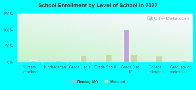
- Number of college students significantly below state average.
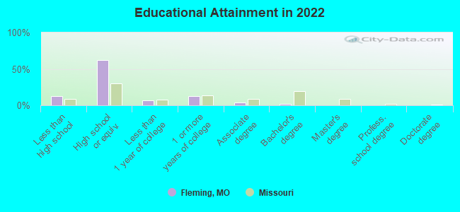
- Percentage of population with a bachelor's degree or higher significantly below state average.