Forney, Idaho
Submit your own pictures of this place and show them to the world
- OSM Map
- General Map
- Google Map
- MSN Map

| Males: 29 | |
| Females: 24 |
| Median resident age: | 50.5 years |
| Idaho median age: | 33.2 years |
Zip code: 83469
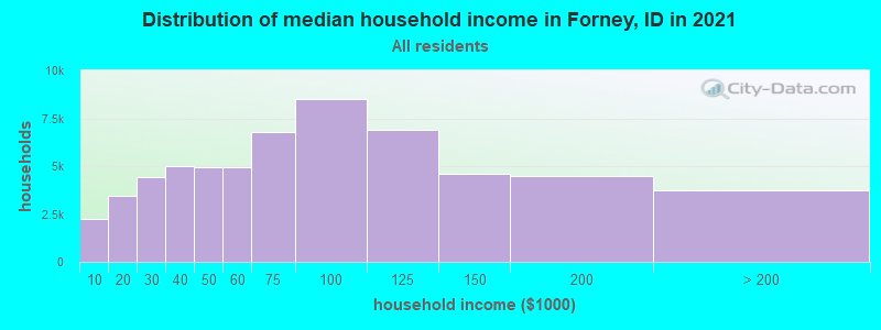
| Forney: | $18,487 |
| ID: | $72,785 |
Estimated per capita income in 2022: $26,561 (it was $12,741 in 2000)
Estimated median house or condo value in 2022: over $1,000,000 (it was $275,000 in 2000)
| Forney: | over $1,000,000 |
| ID: | $432,500 |
Mean prices in 2022: all housing units: $407,354; detached houses: $436,876; townhouses or other attached units: $342,524; mobile homes: $221,567
Detailed information about poverty and poor residents in Forney, ID
Compare current foreclosures near your location:
| Photo | Address | Area | Beds / Baths | Price | Details |
|---|---|---|---|---|---|

|
#1
N Rhodes St
Pretty Prairie, KS 67570
|
1,725 sq. feet
|
2 baths 4 beds |
show details | |

|
#2
S Goddard Rd
Goddard, KS 67052
|
1,054 sq. feet
|
2 baths 2 beds |
show details | |

|
#3
W 21st St N
Cheney, KS 67025
|
3,190 sq. feet
|
3 baths 5 beds |
show details | |

|
#4
E Winterset St
Goddard, KS 67052
|
816 sq. feet
|
1 baths 2 beds |
show details | |

|
#5
NE Waterloo Ave
Murdock, KS 67111
|
1,220 sq. feet
|
1 baths 3 beds |
show details | |

|
#6
W 39th St S
Goddard, KS 67052
|
4,221 sq. feet
|
3 baths 3 beds |
show details | |

|
#7
E Arlington Rd
Haven, KS 67543
|
960 sq. feet
|
1 baths 2 beds |
show details | |

|
#8
S 391st St W
Cheney, KS 67025
|
2,558 sq. feet
|
3 baths 3 beds |
show details | |

|
#9
SE Viney Ave
Murdock, KS 67111
|
- sq. feet
|
- baths - beds |
show details | |

|
#10
W Main St
Mount Hope, KS 67108
|
- sq. feet
|
- baths - beds |
show details |
| Photo | Address | Area | Beds / Baths | Price | Details |
|---|---|---|---|---|---|

|
#11
N 189th Cir W
Colwich, KS 67030
|
- sq. feet
|
- baths - beds |
show details | |

|
#12
N Main St
Goddard, KS 67052
|
- sq. feet
|
- baths - beds |
show details | |

|
#13
Martens Ct
Goddard, KS 67052
|
- sq. feet
|
- baths - beds |
show details | |

|
#14
E 4th Ave Apt 1
Cheney, KS 67025
|
- sq. feet
|
- baths - beds |
show details | |

|
#15
W Maple St Lot D
Goddard, KS 67052
|
- sq. feet
|
- baths - beds |
show details | |

|
#16
W 47th St S
Garden Plain, KS 67050
|
- sq. feet
|
- baths - beds |
show details | |

|
#17
S 339th St W
Cheney, KS 67025
|
- sq. feet
|
- baths - beds |
show details | |

|
#18
E Casey Dr
Goddard, KS 67052
|
- sq. feet
|
- baths - beds |
show details | |

|
Check over 1 million property listings on Foreclosure.com!
|
browse all offers | |||

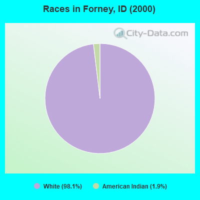
- 5298.1%White alone
- 11.9%American Indian alone
 Recent articles from our blog. Our writers, many of them Ph.D. graduates or candidates, create easy-to-read articles on a wide variety of topics.
Current Local Time: MST time zone
Elevation: 5667 feet
Land area: 1709.7 square miles.
Population density: 0.03 people per square mile (very low).

| Forney CCD: | 0.6% ($1,750) |
| Idaho: | 1.0% ($1,007) |
Nearest city with pop. 50,000+: Missoula, MT  (113.6 miles , pop. 57,053).
Nearest city with pop. 200,000+: Northwest Clackamas, OR (403.9 miles , pop. 224,220).
Nearest city with pop. 1,000,000+: Los Angeles, CA (800.5 miles , pop. 3,694,820).
Nearest cities:
), ), ), )Latitude: 45.23 N, Longitude: 114.32 W
Area code commonly used in this area: 208

| Here: | 4.4% |
| Idaho: | 3.1% |
Average climate in Forney, Idaho
Based on data reported by over 4,000 weather stations


(lower is better)
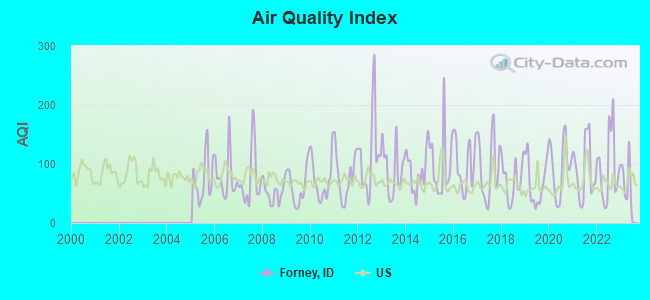
Air Quality Index (AQI) level in 2022 was 94.5. This is worse than average.
| City: | 94.5 |
| U.S.: | 72.6 |
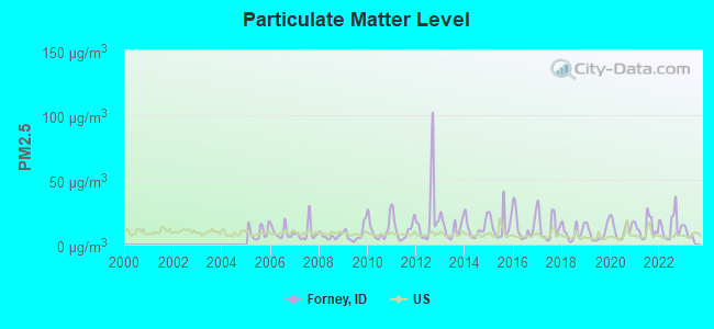
Particulate Matter (PM2.5) [µg/m3] level in 2022 was 14.1. This is significantly worse than average. Closest monitor was 21.0 miles away from the city center.
| City: | 14.1 |
| U.S.: | 8.1 |
Earthquake activity:
Forney-area historical earthquake activity is significantly above Idaho state average. It is 1114% greater than the overall U.S. average.On 10/28/1983 at 14:06:06, a magnitude 7.3 (6.2 MB, 7.3 MS, 7.0 MW, Class: Major, Intensity: VIII - XII) earthquake occurred 83.9 miles away from the city center, causing 2 deaths (2 shaking deaths) and 3 injuries, causing $15,000,000 total damage
On 8/18/1959 at 06:37:13, a magnitude 7.7 (7.7 UK) earthquake occurred 185.2 miles away from Forney center, causing $26,000,000 total damage
On 3/31/2020 at 23:52:30, a magnitude 6.5 (6.5 MW, Depth: 7.5 mi, Class: Strong, Intensity: VII - IX) earthquake occurred 66.2 miles away from the city center
On 10/3/1915 at 06:52:48, a magnitude 7.6 (7.6 UK) earthquake occurred 365.0 miles away from Forney center
On 8/22/1984 at 09:46:30, a magnitude 5.8 (5.0 MB, 5.1 MS, 5.8 ML, Class: Moderate, Intensity: VI - VII) earthquake occurred 54.7 miles away from Forney center
On 10/29/1983 at 23:29:11, a magnitude 5.8 (5.4 MB, 5.0 MS, 5.8 ML) earthquake occurred 65.0 miles away from the city center
Magnitude types: body-wave magnitude (MB), local magnitude (ML), surface-wave magnitude (MS), moment magnitude (MW)
Natural disasters:
The number of natural disasters in Lemhi County (4) is a lot smaller than the US average (15).Major Disasters (Presidential) Declared: 2
Emergencies Declared: 1
Causes of natural disasters: Fire: 1, Flood: 1, Hurricane: 1, Other: 1 (Note: some incidents may be assigned to more than one category).
Colleges/universities with over 2000 students nearest to Forney:
- The University of Montana (about 114 miles; Missoula, MT; Full-time enrollment: 13,602)
- Boise State University (about 147 miles; Boise, ID; FT enrollment: 16,774)
- Lewis-Clark State College (about 154 miles; Lewiston, ID; FT enrollment: 3,199)
- Treasure Valley Community College (about 156 miles; Ontario, OR; FT enrollment: 2,055)
- College of Western Idaho (about 156 miles; Nampa, ID; FT enrollment: 6,300)
- Brigham Young University-Idaho (about 159 miles; Rexburg, ID; FT enrollment: 30,522)
- Northwest Nazarene University (about 161 miles; Nampa, ID; FT enrollment: 2,290)
Points of interest:
Notable locations in Forney: Sleeping Deer Recreation Site (A), Rattlesnake Creek Campground (B), Big Indian Camp (C), Lost Spring Campground (D), Rock Creek Campground (E), Yellowjacket Ranch (F), Yellowjacket Ranger Station (G), Sagebrush Lookout (H), Long Tom Campground (I), Cache Creek Cabin (J), Parrott Placer Campground (K), Kingsbury Ranch (L), Mormon Ranch (M), Simplot Ranch (N), Cow Creek Campsite (O), Lower Grouse Campground (P), Tappan Island Campsite (Q), Cave Campsite (R), Horsetail Campsite (S), Mahoney Campsite (T). Display/hide their locations on the map
Lakes and swamps: Liberty Lakes (A), Yellowjacket Lake (B), Woodtick Lake (C), Lost Lake (D), Lost Packer Lake (E), Wilson Lake (F), White Goat Lake (G), West Fork Lakes (H). Display/hide their locations on the map
Rivers and creeks: Beartrack Creek (A), Cayuse Creek (B), Cave Creek (C), Castle Creek (D), Camas Creek (E), Butte Creek (F), Buckhorn Creek (G), Broomtail Creek (H), Bronco Creek (I). Display/hide their locations on the map
Park in Forney: Idaho Primitive Area (1). Display/hide its location on the map
| This place: | 2.0 people |
| Idaho: | 2.7 people |
| This place: | 48.0% |
| Whole state: | 69.6% |
| This place: | 12.0% |
| Whole state: | 6.3% |
No gay or lesbian households reported
| This place: | 29.6% |
| Whole state: | 11.8% |
For population 15 years and over in Forney:
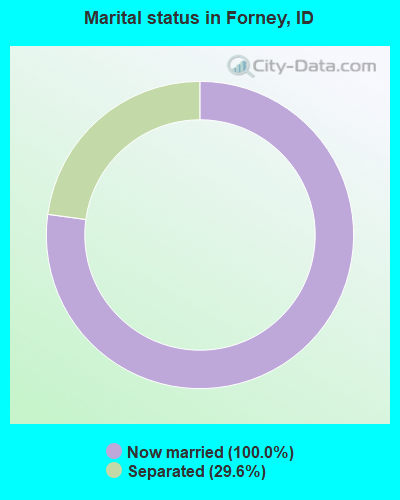
- Never married: 0.0%
- Now married: 100.0%
- Separated: 29.6%
- Widowed: 0.0%
- Divorced: 0.0%
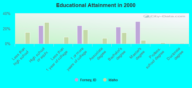
For population 25 years and over in Forney:
- High school or higher: 100.0%
- Bachelor's degree or higher: 51.9%
- Graduate or professional degree: 29.6%
- Mean travel time to work (commute): 15.0 minutes
| Here: | 8.5 |
| Idaho average: | 11.1 |
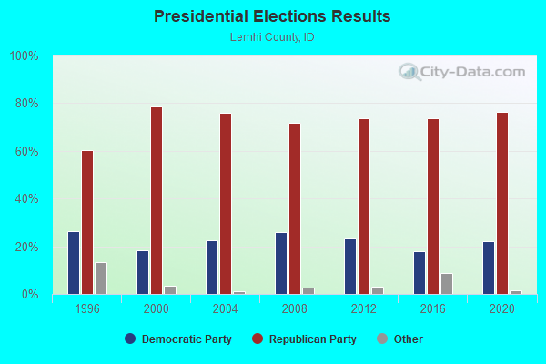

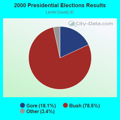
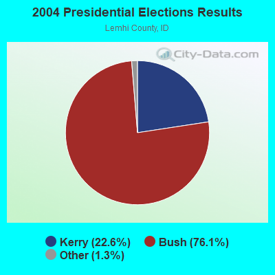

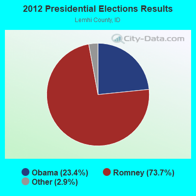
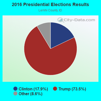
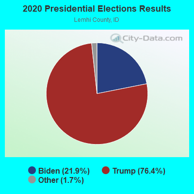
Graphs represent county-level data. Detailed 2008 Election Results
Religion statistics for Forney, ID (based on Lemhi County data)
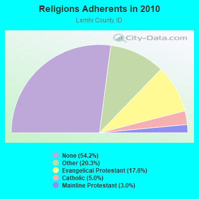
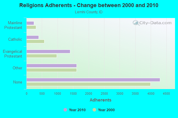
| Religion | Adherents | Congregations |
|---|---|---|
| Other | 1,609 | 5 |
| Evangelical Protestant | 1,398 | 12 |
| Catholic | 394 | 2 |
| Mainline Protestant | 237 | 4 |
| None | 4,298 | - |
Food Environment Statistics:
| This county: | 7.80 / 10,000 pop. |
| Idaho: | 1.88 / 10,000 pop. |
| Lemhi County: | 1.30 / 10,000 pop. |
| Idaho: | 0.53 / 10,000 pop. |
| This county: | 7.80 / 10,000 pop. |
| State: | 3.87 / 10,000 pop. |
| Lemhi County: | 13.00 / 10,000 pop. |
| Idaho: | 7.75 / 10,000 pop. |
| Lemhi County: | 7.8% |
| Idaho: | 7.7% |
| This county: | 26.1% |
| Idaho: | 25.7% |
| Lemhi County: | 7.6% |
| Idaho: | 11.7% |
Strongest AM radio stations in Forney:
- KBOI (670 AM; 50 kW; BOISE, ID; Owner: CITADEL BROADCASTING COMPANY)
- KERR (750 AM; 50 kW; POLSON, MT; Owner: ANDERSON RADIO BROADCASTING, INC.)
- KSRA (960 AM; 1 kW; SALMON, ID; Owner: SALMON RIVER COMMUNICATIONS, INC.)
- KWEI (1260 AM; 50 kW; WEISER, ID; Owner: TREASURE VALLEY BROADCASTING CO.)
- KOFI (1180 AM; 50 kW; KALISPELL, MT; Owner: KOFI, INC.)
- KBOW (550 AM; 5 kW; BUTTE, MT; Owner: BUTTE BROADCASTING INCORPORATED)
- KBSU (730 AM; 15 kW; BOISE, ID; Owner: IDAHO STATE BOARD OF EDUCATION)
- KGA (1510 AM; 50 kW; SPOKANE, WA; Owner: CITADEL BROADCASTING COMPANY)
- KQQQ (1150 AM; 25 kW; PULLMAN, WA; Owner: RADIO PALOUSE, INC.)
- KTBI (810 AM; daytime; 50 kW; EPHRATA, WA; Owner: TACOMA BROADCASTERS, INCORPORATED)
- KALL (700 AM; 50 kW; NORTH SALT LAKE CITY, UT; Owner: CITICASTERS LICENSES, L.P.)
- KGVW (640 AM; 10 kW; BELGRADE, MT; Owner: GALLATIN VALLEY WITNESS, INC.)
- KPOJ (620 AM; 50 kW; PORTLAND, OR; Owner: CITICASTERS LICENSES, L.P.)
Strongest FM radio stations in Forney:
- K204CC (88.7 FM; CHALLIS, ETC., ID; Owner: CHALLIS MISSION CHURCH)
FCC Registered Microwave Towers:
1- COBALT MINE, 54 Formation Road (Lat: 45.139806 Lon: -114.351611), Type: Upole, Structure height: 7.6 m, Call Sign: WRCD682,
Assigned Frequencies: 10995.0 MHz, 11075.0 MHz, 10995.0 MHz, 11075.0 MHz, 10995.0 MHz, 11075.0 MHz, 10995.0 MHz, 11075.0 MHz, 10995.0 MHz, 11075.0 MHz... (+8 more), Grant Date: 09/05/2018, Expiration Date: 09/05/2028, Certifier: Jenness Butterfield, Registrant: Blooston, Mordkofsky, Dickens, Duffy & Prendergast, LLP, 2120 L St Nw Ste 300, Washington, DC 20037-1563, Phone: (202) 828-5519, Email:
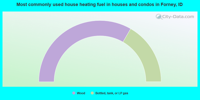
- 66.7%Wood
- 33.3%Bottled, tank, or LP gas
Forney compared to Idaho state average:
- Median household income significantly below state average.
- Median house value significantly above state average.
- Unemployed percentage significantly below state average.
- Black race population percentage significantly below state average.
- Hispanic race population percentage significantly below state average.
- Median age above state average.
- Foreign-born population percentage significantly below state average.
- Length of stay since moving in significantly above state average.
- Number of rooms per house significantly below state average.
- House age significantly below state average.
- Number of college students significantly below state average.
- Percentage of population with a bachelor's degree or higher significantly above state average.