Fort Calhoun, Nebraska
Submit your own pictures of this city and show them to the world
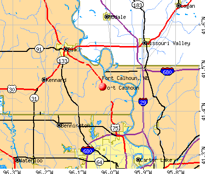
- OSM Map
- General Map
- Google Map
- MSN Map
Population change since 2000: +30.3%
 |
| Males: 541 | |
| Females: 574 |
| Median resident age: | 44.7 years |
| Nebraska median age: | 37.4 years |
Zip codes: 68023.
| Fort Calhoun: | $73,651 |
| NE: | $69,597 |
Estimated per capita income in 2022: $37,988 (it was $20,779 in 2000)
Fort Calhoun city income, earnings, and wages data
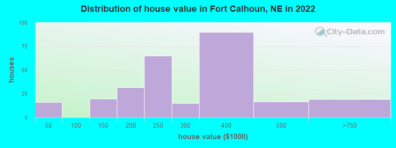
Estimated median house or condo value in 2022: $267,554 (it was $94,500 in 2000)
| Fort Calhoun: | $267,554 |
| NE: | $232,400 |
Mean prices in 2022: all housing units: $239,407; detached houses: $263,163; mobile homes: $8,476
Median gross rent in 2022: $1,022.
(10.5% for White Non-Hispanic residents, 21.6% for two or more races residents)
Detailed information about poverty and poor residents in Fort Calhoun, NE
Compare current foreclosures near Fort Calhoun, NE:
| Photo | Address | Area | Beds / Baths | Price | Details |
|---|---|---|---|---|---|

|
#1
Madison St Lot 1
Fort Calhoun, NE 68023
|
1,216 sq. feet
|
- baths - beds |
show details | |

|
#2
County Road 39
Fort Calhoun, NE 68023
|
1,274 sq. feet
|
- baths - beds |
show details | |

|
#3
Stutsman St
Council Bluffs, IA 51503
|
1,248 sq. feet
|
1 baths 3 beds |
$66,100
|
show details |

|
#4
S 31st Ave Apt 4700
Omaha, NE 68131
|
1,455 sq. feet
|
2 baths 2 beds |
show details | |

|
#5
South 13th Court
Omaha, NE 68108
|
- sq. feet
|
- baths - beds |
$100,000
|
show details |

|
#6
S 121st Plz Apt 215
Omaha, NE 68144
|
920 sq. feet
|
1 baths 2 beds |
show details | |

|
#7
Camden Ave
Omaha, NE 68104
|
768 sq. feet
|
1 baths 2 beds |
show details | |

|
#8
N 225th St
Valley, NE 68064
|
1,412 sq. feet
|
2 baths 3 beds |
show details | |

|
#9
Davidson St
Bennington, NE 68007
|
1,048 sq. feet
|
2 baths 3 beds |
show details | |

|
#10
N 211th St
Elkhorn, NE 68022
|
1,628 sq. feet
|
2 baths 3 beds |
show details |
| Photo | Address | Area | Beds / Baths | Price | Details |
|---|---|---|---|---|---|

|
#11
N 78th Ter
Omaha, NE 68122
|
1,082 sq. feet
|
2 baths 3 beds |
show details | |

|
#12
Fort St
Omaha, NE 68104
|
1,453 sq. feet
|
1 baths 3 beds |
show details | |

|
#13
S 78th Ave
Omaha, NE 68127
|
995 sq. feet
|
1 baths 3 beds |
show details | |

|
#14
N 56th St
Omaha, NE 68104
|
1,150 sq. feet
|
1 baths 2 beds |
show details | |

|
#15
N 20th St
Omaha, NE 68110
|
1,740 sq. feet
|
2 baths 3 beds |
show details | |

|
#16
Bedford Ave
Omaha, NE 68116
|
1,312 sq. feet
|
2 baths 3 beds |
show details | |

|
#17
N 76th St
Omaha, NE 68114
|
1,249 sq. feet
|
1 baths 3 beds |
show details | |

|
#18
Webster St
Omaha, NE 68114
|
864 sq. feet
|
1 baths 3 beds |
show details | |

|
#19
Pratt St
Omaha, NE 68111
|
1,088 sq. feet
|
1 baths 2 beds |
show details | |

|
#20
N 77th Ave
Omaha, NE 68114
|
1,072 sq. feet
|
1 baths 3 beds |
show details |
| Photo | Address | Area | Beds / Baths | Price | Details |
|---|---|---|---|---|---|

|
#21
N 85th St
Omaha, NE 68114
|
1,886 sq. feet
|
2 baths 3 beds |
show details | |

|
#22
Izard St
Omaha, NE 68114
|
3,323 sq. feet
|
2 baths 3 beds |
show details | |

|
#23
Sahler St
Omaha, NE 68116
|
2,872 sq. feet
|
3 baths 4 beds |
show details | |

|
#24
N 122nd Cir
Omaha, NE 68164
|
2,058 sq. feet
|
2 baths 3 beds |
show details | |

|
#25
Lafayette Ave
Omaha, NE 68132
|
1,536 sq. feet
|
1 baths 3 beds |
show details | |

|
#26
N 34th St
Omaha, NE 68111
|
768 sq. feet
|
1 baths 2 beds |
show details | |

|
#27
Hamilton St
Omaha, NE 68132
|
2,048 sq. feet
|
1 baths 3 beds |
show details | |

|
#28
N 125th Ave
Omaha, NE 68164
|
1,878 sq. feet
|
2 baths 3 beds |
show details | |

|
#29
Decatur St
Omaha, NE 68111
|
624 sq. feet
|
1 baths 1 beds |
show details | |

|
#30
Pratt St
Omaha, NE 68111
|
812 sq. feet
|
1 baths 2 beds |
show details |
| Photo | Address | Area | Beds / Baths | Price | Details |
|---|---|---|---|---|---|

|
#31
Charles St
Omaha, NE 68132
|
900 sq. feet
|
1 baths 3 beds |
show details | |

|
#32
Lincoln Blvd
Omaha, NE 68131
|
1,470 sq. feet
|
1 baths 3 beds |
show details | |

|
#33
Sherwood Ave
Omaha, NE 68116
|
2,470 sq. feet
|
2 baths 4 beds |
show details | |

|
#34
Chicago St
Omaha, NE 68132
|
1,012 sq. feet
|
1 baths 2 beds |
show details | |

|
#35
Road L34
Neola, IA 51559
|
1,480 sq. feet
|
1 baths 3 beds |
show details | |

|
#36
Avenue M
Council Bluffs, IA 51501
|
1,239 sq. feet
|
1 baths 2 beds |
show details | |

|
#37
Burt St
Omaha, NE 68154
|
2,323 sq. feet
|
3 baths 3 beds |
show details | |

|
#38
Poppleton Ave
Omaha, NE 68106
|
1,732 sq. feet
|
1 baths 2 beds |
show details | |

|
#39
Westover Rd
Omaha, NE 68154
|
1,845 sq. feet
|
1 baths 4 beds |
show details | |

|
#40
Parker St
Omaha, NE 68118
|
2,787 sq. feet
|
2 baths 4 beds |
show details |
| Photo | Address | Area | Beds / Baths | Price | Details |
|---|---|---|---|---|---|

|
#41
Pratt St
Omaha, NE 68134
|
1,435 sq. feet
|
2 baths 3 beds |
show details | |

|
#42
Franklin St
Omaha, NE 68118
|
1,925 sq. feet
|
2 baths 3 beds |
show details | |

|
#43
S 49th St
Omaha, NE 68106
|
864 sq. feet
|
1 baths 2 beds |
show details | |

|
#44
N 93rd Ct
Omaha, NE 68114
|
1,872 sq. feet
|
2 baths 2 beds |
show details | |

|
#45
Charles Plz
Omaha, NE 68154
|
1,885 sq. feet
|
2 baths 3 beds |
show details | |

|
#46
N 169th St
Omaha, NE 68116
|
2,808 sq. feet
|
2 baths 4 beds |
show details | |

|
#47
N 152nd Plz
Omaha, NE 68154
|
1,432 sq. feet
|
2 baths 3 beds |
show details | |

|
#48
Pratt St
Omaha, NE 68111
|
1,080 sq. feet
|
1 baths 3 beds |
show details | |

|
#49
Florence Blvd
Omaha, NE 68110
|
1,124 sq. feet
|
1 baths 2 beds |
show details | |

|
Check over 1 million property listings on Foreclosure.com!
|
browse all offers | |||


- 99185.5%White alone
- 887.6%Two or more races
- 736.3%Hispanic
- 60.5%Black alone
- 60.5%Other race alone
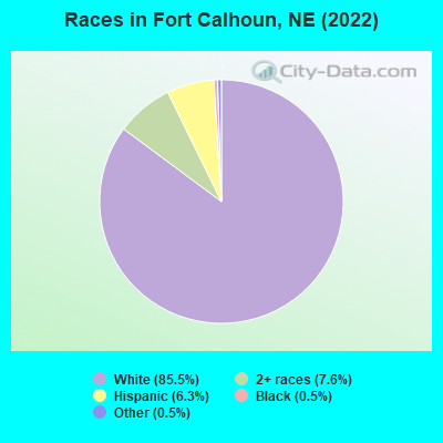
Races in Fort Calhoun detailed stats: ancestries, foreign born residents, place of birth
 Recent articles from our blog. Our writers, many of them Ph.D. graduates or candidates, create easy-to-read articles on a wide variety of topics.

 | Chicken Farm-How many miles do they smell for? (2 replies) |
| Fort Calhoun Nuclear Power Plant (18 replies) |
| Moving to Omaha - opinions on areas/subdivisions/schools please! (4 replies) |
| Omaha, 1.5 million people by 2050?? (56 replies) |
| Pilger Tornadoes 6/16/14 (11 replies) |
| Neighborhoods to stay away from? (327 replies) |
Latest news from Fort Calhoun, NE collected exclusively by city-data.com from local newspapers, TV, and radio stations
Ancestries: German (24.7%), Irish (9.3%), English (6.9%), Italian (6.9%), Czech (4.8%), European (3.9%).
Current Local Time: CST time zone
Elevation: 1110 feet
Land area: 0.62 square miles.
Population density: 1,798 people per square mile (low).
11 residents are foreign born
| This city: | 0.9% |
| Nebraska: | 7.5% |
Median real estate property taxes paid for housing units with mortgages in 2022: $4,493 (1.6%)
Median real estate property taxes paid for housing units with no mortgage in 2022: $5,016 (2.0%)
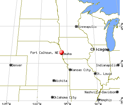
Nearest city with pop. 50,000+: Omaha, NE  (13.6 miles , pop. 390,007).
Nearest city with pop. 1,000,000+: Chicago, IL (432.0 miles , pop. 2,896,016).
Nearest cities:
), )Latitude: 41.46 N, Longitude: 96.02 W
Area code: 402

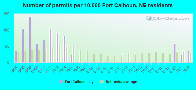
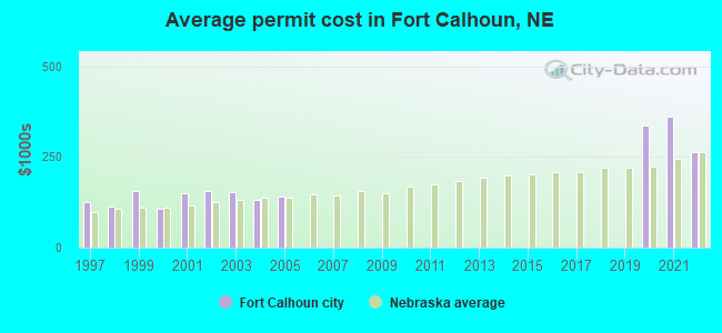
Single-family new house construction building permits:
- 2022: 3 buildings, average cost: $263,900
- 2021: 2 buildings, average cost: $361,700
- 2020: 5 buildings, average cost: $337,300
- 2005: 2 buildings, average cost: $140,000
- 2004: 7 buildings, average cost: $132,100
- 2003: 8 buildings, average cost: $153,300
- 2002: 9 buildings, average cost: $155,200
- 2001: 6 buildings, average cost: $151,200
- 2000: 5 buildings, average cost: $107,200
- 1999: 12 buildings, average cost: $154,800
- 1998: 9 buildings, average cost: $111,900
- 1997: 3 buildings, average cost: $123,700
| Here: | 2.0% |
| Nebraska: | 2.2% |
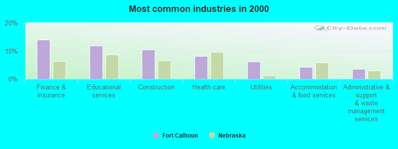
- Finance & insurance (14.0%)
- Educational services (11.9%)
- Construction (10.5%)
- Health care (8.1%)
- Utilities (6.2%)
- Accommodation & food services (4.3%)
- Administrative & support & waste management services (3.6%)
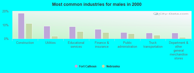
- Construction (18.5%)
- Utilities (9.3%)
- Educational services (8.8%)
- Finance & insurance (6.9%)
- Public administration (4.6%)
- Truck transportation (4.2%)
- Department & other general merchandise stores (4.2%)

- Finance & insurance (21.5%)
- Educational services (15.1%)
- Health care (14.1%)
- Accommodation & food services (5.9%)
- U. S. Postal service (4.4%)
- Professional, scientific, technical services (4.4%)
- Food & beverage stores (3.4%)

- Secretaries and administrative assistants (6.7%)
- Other office and administrative support workers, including supervisors (5.0%)
- Building and grounds cleaning and maintenance occupations (4.0%)
- Metal workers and plastic workers (3.8%)
- Other sales and related occupations, including supervisors (3.6%)
- Preschool, kindergarten, elementary, and middle school teachers (3.1%)
- Other management occupations, except farmers and farm managers (3.1%)

- Metal workers and plastic workers (7.4%)
- Top executives (4.6%)
- Preschool, kindergarten, elementary, and middle school teachers (4.6%)
- Driver/sales workers and truck drivers (4.6%)
- Electrical equipment mechanics and other installation, maintenance, and repair workers, including supervisors (4.2%)
- Construction laborers (4.2%)
- Carpenters (4.2%)

- Secretaries and administrative assistants (13.7%)
- Other office and administrative support workers, including supervisors (6.3%)
- Cooks and food preparation workers (5.4%)
- Building and grounds cleaning and maintenance occupations (4.9%)
- Supervisors and other personal care and service workers, except child care workers (4.4%)
- Information and record clerks, except customer service representatives (3.9%)
- Material recording, scheduling, dispatching, and distributing workers (3.9%)
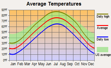
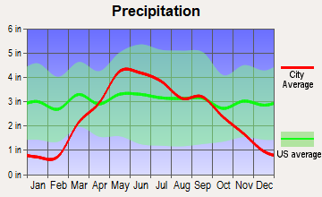
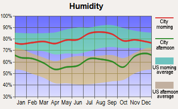
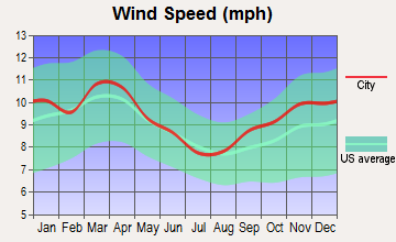
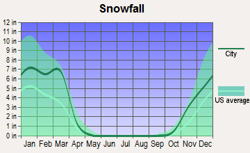
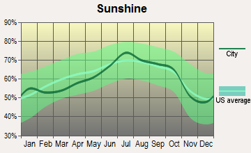
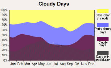
Average climate in Fort Calhoun, Nebraska
Based on data reported by over 4,000 weather stations
(lower is better)
Air Quality Index (AQI) level in 2023 was 104. This is significantly worse than average.
| City: | 104 |
| U.S.: | 73 |
Carbon Monoxide (CO) [ppm] level in 2023 was 0.195. This is better than average. Closest monitor was 10.9 miles away from the city center.
| City: | 0.195 |
| U.S.: | 0.251 |
Sulfur Dioxide (SO2) [ppb] level in 2023 was 0.534. This is significantly better than average. Closest monitor was 6.7 miles away from the city center.
| City: | 0.534 |
| U.S.: | 1.515 |
Ozone [ppb] level in 2023 was 35.4. This is about average. Closest monitor was 6.7 miles away from the city center.
| City: | 35.4 |
| U.S.: | 33.3 |
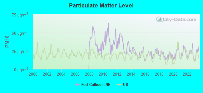
Particulate Matter (PM10) [µg/m3] level in 2023 was 21.9. This is about average. Closest monitor was 13.7 miles away from the city center.
| City: | 21.9 |
| U.S.: | 19.2 |
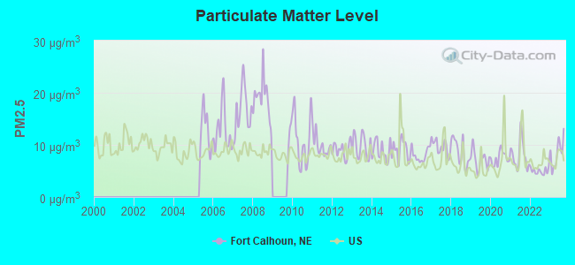
Particulate Matter (PM2.5) [µg/m3] level in 2023 was 8.42. This is about average. Closest monitor was 6.8 miles away from the city center.
| City: | 8.42 |
| U.S.: | 8.11 |
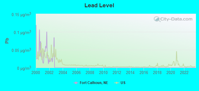
Lead (Pb) [µg/m3] level in 2002 was 0.0298. This is significantly worse than average. Closest monitor was 14.3 miles away from the city center.
| City: | 0.0298 |
| U.S.: | 0.0093 |
Tornado activity:
Fort Calhoun-area historical tornado activity is near Nebraska state average. It is 86% greater than the overall U.S. average.
On 5/6/1975, a category F4 (max. wind speeds 207-260 mph) tornado 12.2 miles away from the Fort Calhoun city center killed 3 people and injured 133 people and caused between $50,000 and $500,000 in damages.
On 4/25/1957, a category F4 tornado 19.1 miles away from the city center killed one person and injured 8 people and caused between $500,000 and $5,000,000 in damages.
Earthquake activity:
Fort Calhoun-area historical earthquake activity is significantly above Nebraska state average. It is 300% greater than the overall U.S. average.On 9/3/2016 at 12:02:44, a magnitude 5.8 (5.8 MW, Depth: 3.5 mi, Class: Moderate, Intensity: VI - VII) earthquake occurred 351.4 miles away from the city center
On 11/6/2011 at 03:53:10, a magnitude 5.7 (5.7 MW, Depth: 3.2 mi) earthquake occurred 411.7 miles away from the city center
On 11/3/2002 at 20:41:56, a magnitude 4.3 (4.3 MB, Depth: 3.1 mi, Class: Light, Intensity: IV - V) earthquake occurred 173.0 miles away from Fort Calhoun center
On 6/22/2019 at 08:50:24, a magnitude 4.6 (4.6 MW, Depth: 1.9 mi) earthquake occurred 237.0 miles away from the city center
On 11/12/2014 at 21:40:00, a magnitude 4.9 (4.9 MW, Depth: 2.5 mi) earthquake occurred 301.8 miles away from Fort Calhoun center
On 3/4/1983 at 06:32:18, a magnitude 4.6 (4.4 MB, 4.6 LG, 4.4 ML) earthquake occurred 256.5 miles away from Fort Calhoun center
Magnitude types: regional Lg-wave magnitude (LG), body-wave magnitude (MB), local magnitude (ML), moment magnitude (MW)
Natural disasters:
The number of natural disasters in Washington County (16) is near the US average (15).Major Disasters (Presidential) Declared: 12
Emergencies Declared: 2
Causes of natural disasters: Floods: 12, Storms: 8, Tornadoes: 5, Snows: 2, Winds: 2, Winter Storms: 2, Hurricane: 1, Snowstorm: 1, Other: 1 (Note: some incidents may be assigned to more than one category).

Hospitals and medical centers near Fort Calhoun:
- CROWELL MEMORIAL HOME (Nursing Home, about 9 miles away; BLAIR, NE)
- GOOD SHEPHERD LUTHERAN HOME (Nursing Home, about 10 miles away; BLAIR, NE)
- MEMORIAL COMMUNITY HOSPITAL Critical Access Hospitals (about 10 miles away; BLAIR, NE)
- FLORENCE HOME (Nursing Home, about 10 miles away; OMAHA, NE)
- IMMANUEL-VNA HOME CARE (Home Health Center, about 10 miles away; OMAHA, NE)
- ALEGENT HEALTH IMMANUEL MEDICAL CENTER Acute Care Hospitals (about 10 miles away; OMAHA, NE)
- NEBRASKA SPINE HOSPITAL, LLC Acute Care Hospitals (about 10 miles away; OMAHA, NE)
Airports located in Fort Calhoun:
- Heaton Airport (75NE) (Runways: 1)
Nuclear power plants:
Fort Calhoun . General Electric Co.Gibbs & Hill, Inc.Combustion Engineering. Inc.Omaha Public Power District. Pressurized Water Reactor (PWR). Net Output: 478 MWe. Operable. Initial criticality: 08/1973. Commercial start: 09/1973..
Colleges/universities with over 2000 students nearest to Fort Calhoun:
- Metropolitan Community College Area (about 12 miles; Omaha, NE; Full-time enrollment: 12,236)
- University of Nebraska at Omaha (about 14 miles; Omaha, NE; FT enrollment: 12,073)
- Creighton University (about 14 miles; Omaha, NE; FT enrollment: 5,370)
- University of Nebraska Medical Center (about 15 miles; Omaha, NE; FT enrollment: 2,815)
- Iowa Western Community College (about 18 miles; Council Bluffs, IA; FT enrollment: 5,344)
- Bellevue University (about 22 miles; Bellevue, NE; FT enrollment: 7,139)
- Nebraska Wesleyan University (about 54 miles; Lincoln, NE; FT enrollment: 2,072)
Public high school in Fort Calhoun:
- FORT CALHOUN HIGH SCHOOL (Students: 308, Location: 1506 LINCOLN ST, Grades: 7-12)
Public elementary/middle school in Fort Calhoun:
- FORT CALHOUN ELEMENTARY SCHOOL (Students: 289, Location: 1120 MONROE ST, Grades: PK-6)
Points of interest:
Notable locations in Fort Calhoun: Fort Calhoun Volunteer Fire and Rescue Department (A), Washington County Historical Museum (B). Display/hide their locations on the map
Churches in Fort Calhoun include: Presbyterian Church (A), Saint John the Baptist Catholic Church (B), Fort Calhoun Baptist Church (C). Display/hide their locations on the map
Park in Fort Calhoun: Fort Atkinson Historical Marker (1). Display/hide its location on the map
Tourist attraction: Fort Calhoun Keno Lottery (Amusement & Theme Parks; 101 South 14th Street).
Hotel: Four Seasons Home Improvement (6341 County Road 40).
Drinking water stations with addresses in Fort Calhoun and their reported violations in the past:
FORT CALHOUN, CITY OF (Population served: 906, Purch surface water):Past health violations:Past monitoring violations:
- MCL, Average - Between JAN-2012 and MAR-2012, Contaminant: TTHM. Follow-up actions: St Public Notif requested (APR-09-2012), St Violation/Reminder Notice (APR-09-2012), St Public Notif received (MAY-07-2012), St Compliance achieved (SEP-30-2012)
- One routine major monitoring violation
| This city: | 2.3 people |
| Nebraska: | 2.5 people |
| This city: | 64.7% |
| Whole state: | 64.8% |
| This city: | 4.6% |
| Whole state: | 6.0% |
Likely homosexual households (counted as self-reported same-sex unmarried-partner households)
- Lesbian couples: 0.0% of all households
- Gay men: 0.3% of all households
Banks with branches in Fort Calhoun (2011 data):
- Great Southern Bank: Fort Calhoun Branch at 101 North 14th Street, branch established on 1974/01/02. Info updated 2012/02/03: Bank assets: $3,788.7 mil, Deposits: $2,986.3 mil, headquarters in Reeds Spring, MO, positive income, Commercial Lending Specialization, 109 total offices, Holding Company: Great Southern Bancorp, Inc.
For population 15 years and over in Fort Calhoun:
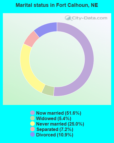
- Never married: 25.0%
- Now married: 51.6%
- Separated: 7.2%
- Widowed: 5.4%
- Divorced: 10.9%
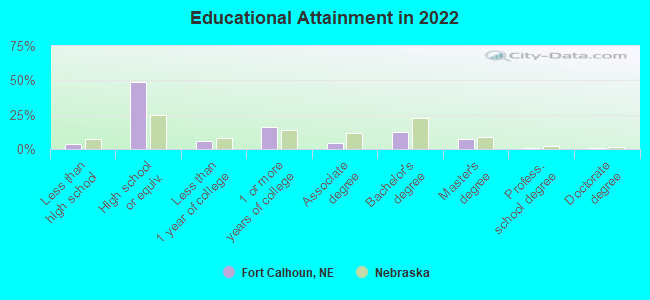
For population 25 years and over in Fort Calhoun:
- High school or higher: 95.5%
- Bachelor's degree or higher: 19.9%
- Graduate or professional degree: 8.3%
- Unemployed: 4.8%
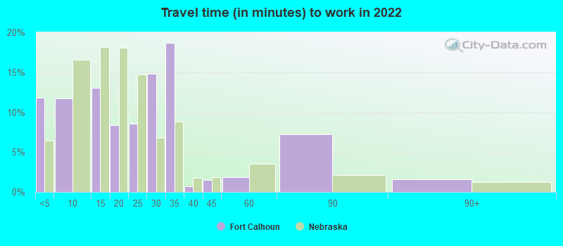
- Mean travel time to work (commute): 21.1 minutes
| Here: | 8.3 |
| Nebraska average: | 11.2 |
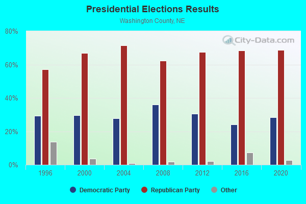
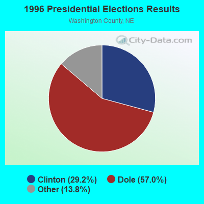


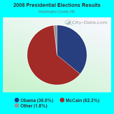
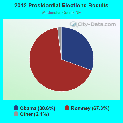
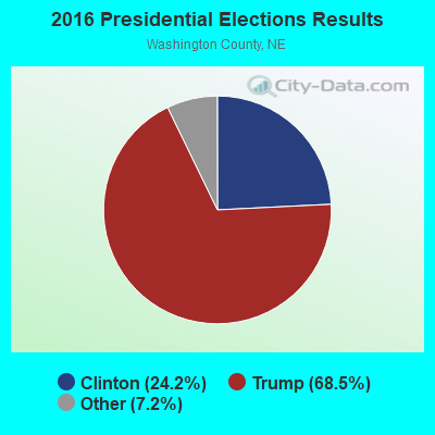

Graphs represent county-level data. Detailed 2008 Election Results
Religion statistics for Fort Calhoun, NE (based on Washington County data)
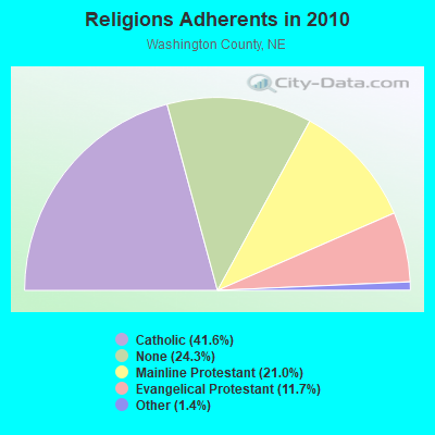
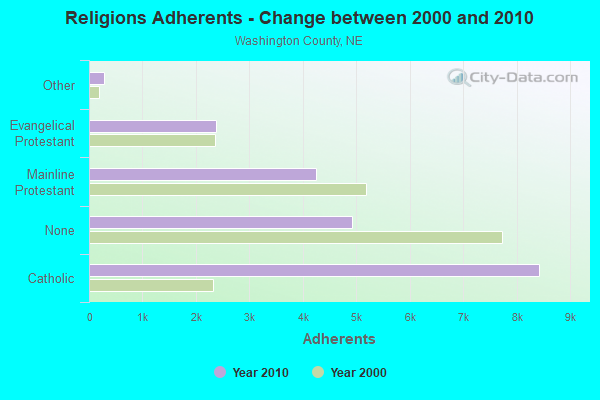
| Religion | Adherents | Congregations |
|---|---|---|
| Catholic | 8,421 | 3 |
| Mainline Protestant | 4,240 | 11 |
| Evangelical Protestant | 2,368 | 10 |
| Other | 283 | 2 |
| None | 4,922 | - |
Food Environment Statistics:
| Washington County: | 2.51 / 10,000 pop. |
| Nebraska: | 2.60 / 10,000 pop. |
| Washington County: | 3.01 / 10,000 pop. |
| Nebraska: | 4.83 / 10,000 pop. |
| Here: | 7.03 / 10,000 pop. |
| Nebraska: | 7.76 / 10,000 pop. |
| Washington County: | 7.7% |
| Nebraska: | 7.9% |
| Washington County: | 27.2% |
| State: | 28.0% |
| Washington County: | 11.0% |
| Nebraska: | 12.9% |
Health and Nutrition:
| Fort Calhoun: | 51.7% |
| State: | 48.9% |
| Fort Calhoun: | 49.6% |
| Nebraska: | 45.5% |
| Here: | 28.7 |
| Nebraska: | 28.6 |
| Fort Calhoun: | 19.7% |
| Nebraska: | 21.4% |
| This city: | 9.7% |
| State: | 10.5% |
| This city: | 6.9 |
| State: | 6.8 |
| Here: | 34.1% |
| Nebraska: | 33.5% |
| This city: | 59.0% |
| State: | 55.6% |
| This city: | 78.5% |
| Nebraska: | 78.2% |
More about Health and Nutrition of Fort Calhoun, NE Residents
| Local government employment and payroll (March 2022) | |||||
| Function | Full-time employees | Monthly full-time payroll | Average yearly full-time wage | Part-time employees | Monthly part-time payroll |
|---|---|---|---|---|---|
| Financial Administration | 1 | $7,833 | $93,996 | 0 | $0 |
| Water Supply | 0 | $0 | 1 | $2,187 | |
| Sewerage | 0 | $0 | 1 | $1,352 | |
| Streets and Highways | 0 | $0 | 1 | $1,236 | |
| Other Government Administration | 0 | $0 | 1 | $195 | |
| Other and Unallocable | 0 | $0 | 1 | $1,610 | |
| Parks and Recreation | 0 | $0 | 1 | $1,577 | |
| Totals for Government | 1 | $7,833 | $93,996 | 6 | $8,157 |
Fort Calhoun government finances - Expenditure in 2021 (per resident):
- Construction - Parks and Recreation: $354,000 ($317.49)
Sewerage: $224,000 ($200.90)
Libraries: $118,000 ($105.83)
Regular Highways: $60,000 ($53.81)
Water Utilities: $8,000 ($7.17)
- Current Operations - Water Utilities: $254,000 ($227.80)
Regular Highways: $241,000 ($216.14)
Sewerage: $216,000 ($193.72)
Central Staff Services: $135,000 ($121.08)
Financial Administration: $103,000 ($92.38)
Parks and Recreation: $91,000 ($81.61)
Police Protection: $43,000 ($38.57)
Libraries: $30,000 ($26.91)
Local Fire Protection: $27,000 ($24.22)
General Public Buildings: $21,000 ($18.83)
- General - Interest on Debt: $72,000 ($64.57)
- Other Capital Outlay - Police Protection: $43,000 ($38.57)
Local Fire Protection: $27,000 ($24.22)
Parks and Recreation: $15,000 ($13.45)
Libraries: $5,000 ($4.48)
- Total Salaries and Wages: $545,000 ($488.79)
Fort Calhoun government finances - Revenue in 2021 (per resident):
- Charges - Sewerage: $360,000 ($322.87)
Other: $253,000 ($226.91)
Parks and Recreation: $20,000 ($17.94)
- Miscellaneous - General Revenue - Other: $197,000 ($176.68)
Interest Earnings: $19,000 ($17.04)
- Revenue - Water Utilities: $381,000 ($341.70)
- State Intergovernmental - Highways: $110,000 ($98.65)
General Local Government Support: $4,000 ($3.59)
- Tax - Property: $551,000 ($494.17)
Other License: $303,000 ($271.75)
General Sales and Gross Receipts: $214,000 ($191.93)
Fort Calhoun government finances - Debt in 2021 (per resident):
- Long Term Debt - Beginning Outstanding - Unspecified Public Purpose: $2,343,000 ($2101.35)
Outstanding Unspecified Public Purpose: $1,800,000 ($1614.35)
Retired Unspecified Public Purpose: $543,000 ($487.00)
Fort Calhoun government finances - Cash and Securities in 2021 (per resident):
- Other Funds - Cash and Securities: $925,000 ($829.60)
Strongest AM radio stations in Fort Calhoun:
- KKAR (1290 AM; 50 kW; OMAHA, NE; Owner: WAITT RADIO, INC.)
- KFAB (1110 AM; 50 kW; OMAHA, NE; Owner: CAPSTAR TX LIMITED PARTNERSHIP)
- KOMJ (590 AM; 5 kW; OMAHA, NE; Owner: JOURNAL BROADCAST CORPORATION)
- KYDZ (1180 AM; 25 kW; BELLEVUE, NE; Owner: WAITT RADIO, INC.)
- KOIL (1020 AM; 50 kW; PLATTSMOUTH, NE; Owner: WAITT RADIO, INC.)
- KLNG (1560 AM; daytime; 10 kW; COUNCIL BLUFFS, IA)
- KOZN (1620 AM; 10 kW; BELLEVUE, NE; Owner: WAITT RADIO, INC.)
- KCRO (660 AM; 1 kW; OMAHA, NE; Owner: ETERNAL BROADCASTING, LLC)
- KTIC (840 AM; daytime; 5 kW; WEST POINT, NE; Owner: WEST POINT BROADCASTING, INC.)
- KOSR (1490 AM; 1 kW; OMAHA, NE; Owner: JOURNAL BROADCAST CORPORATION)
- WHO (1040 AM; 50 kW; DES MOINES, IA; Owner: CITICASTERS LICENSES, L.P.)
- WHB (810 AM; 50 kW; KANSAS CITY, MO; Owner: UNION BROADCASTING, INC.)
- KHLP (1420 AM; 1 kW; OMAHA, NE; Owner: JOURNAL BROADCAST CORPORATION)
Strongest FM radio stations in Fort Calhoun:
- KMLV (88.1 FM; RALSTON, NE; Owner: EDUCATIONAL MEDIA FOUNDATION)
- KEZO-FM (92.3 FM; OMAHA, NE; Owner: JOURNAL BROADCAST CORPORATION)
- KGOR (99.9 FM; OMAHA, NE; Owner: CAPSTAR TX LIMITED PARTNERSHIP)
- KQKQ-FM (98.5 FM; COUNCIL BLUFFS, IA; Owner: WAITT RADIO, INC.)
- KQCH (94.1 FM; OMAHA, NE; Owner: JOURNAL BROADCAST CORPORATION)
- KIWR (89.7 FM; COUNCIL BLUFFS, IA; Owner: IOWA WESTERN COMMUNITY COLLEGE)
- KSRZ (104.5 FM; OMAHA, NE; Owner: JOURNAL BROADCAST CORPORATION)
- KVNO (90.7 FM; OMAHA, NE; Owner: THE BOARD OF REGENTS OF UNIV. OF NEBRASKA)
- KRQC (93.3 FM; BENNINGTON, NE; Owner: CAPSTAR TX LIMITED PARTNERSHIP)
- KKCD (105.9 FM; OMAHA, NE; Owner: JOURNAL BROADCAST CORPORATION)
- KVSS (88.9 FM; OMAHA, NE; Owner: VSS CATHOLIC COMMUNICATIONS, INC.)
- KIOS-FM (91.5 FM; OMAHA, NE; Owner: DOUGLAS COUNTY SCHOOL DISTRICT 001)
- KEFM (96.1 FM; OMAHA, NE; Owner: WEBSTER COMMUNICATIONS CO.)
- KKYY (101.3 FM; WHITING, IA; Owner: WMMP, LLC)
- KXKT (103.7 FM; GLENWOOD, IA; Owner: CAPSTAR TX LIMITED PARTNERSHIP)
- KLTQ (101.9 FM; LINCOLN, NE; Owner: WAITT RADIO, INC.)
- KGBI-FM (100.7 FM; OMAHA, NE; Owner: GRACE UNIVERSITY)
- K299AK (107.7 FM; OMAHA, NE; Owner: BAER COMMUNICATIONS, INC.)
- KBBX-FM (97.7 FM; NEBRASKA CITY, NE; Owner: JOURNAL BROADCAST CORPORATION)
- KFMT-FM (105.5 FM; FREMONT, NE; Owner: WAITT RADIO, INC.)
TV broadcast stations around Fort Calhoun:
- KMTV (Channel 3; OMAHA, NE; Owner: EMMIS TELEVISION LICENSE CORPORATION)
- KETV (Channel 7; OMAHA, NE; Owner: KETV HEARST-ARGYLE TELEVISION, INC.)
- WOWT-TV (Channel 6; OMAHA, NE; Owner: GRAY MIDAMERICA TV LICENSEE CORP.)
- KYNE-TV (Channel 26; OMAHA, NE; Owner: NEBRASKA EDUCATIONAL TELECOMMUNICATIONS COMM.)
- KVSS-LP (Channel 67; OMAHA, NE; Owner: VSS CATHOLIC COMMUNICATIONS)
- KPTM (Channel 42; OMAHA, NE; Owner: PAPPAS TELECASTING OF THE MIDLANDS)
- KXVO (Channel 15; OMAHA, NE; Owner: MITTS TELECASTING COMPANY)
- KUON-TV (Channel 12; LINCOLN, NE; Owner: THE UNIVERSITY OF NEBRASKA)
- K61GA (Channel 61; OMAHA, NE; Owner: THREE ANGELS BROADCASTING NETWORK)
- K21ES (Channel 21; COLUMBUS, ETC, NE; Owner: DAVID C. BRODAHL)
- KHIN (Channel 36; RED OAK, IA; Owner: IOWA PUBLIC BROADCASTING BOARD)
- KOHA-LP (Channel 65; OMAHA, NE; Owner: K. SANDOVAL BURKE)
- K54EU (Channel 54; COLUMBUS-FREMONT, NE; Owner: GLENDA R. HARDERS)
- KKAZ-CA (Channel 24; OMAHA, NE; Owner: PAPPAS TELECASTING OF THE MIDLANDS)
- K53EY (Channel 53; OMAHA, NE; Owner: TV-45, INC.)
- K68AV (Channel 68; BLAIR, NE; Owner: NEBRASKA EDTV COMMISSION)
- National Bridge Inventory (NBI) Statistics
- 7Number of bridges
- 66ft / 19.7mTotal length
- 10,005Total average daily traffic
- 879Total average daily truck traffic
- 11,629Total future (year 2033) average daily traffic
FCC Registered Antenna Towers:
10 (See the full list of FCC Registered Antenna Towers in Fort Calhoun)FCC Registered Broadcast Land Mobile Towers:
3- 4 Mi S & 2 Mi E (Lat: 41.393889 Lon: -95.975556), Call Sign: KNEY538, Licensee ID: L00003457,
Assigned Frequencies: 453.725 MHz, Grant Date: 01/28/2003, Expiration Date: 02/12/2013, Cancellation Date: 04/20/2013, Registrant: State Of Nebraska, 1300 Military Rd, Lincoln, NE 68508-1090
- Lat: 41.520556 Lon: -96.077528, Call Sign: WQFC582,
Assigned Frequencies: 467.437 MHz, 462.137 MHz, Grant Date: 03/19/2016, Expiration Date: 06/15/2026, Certifier: Diane R Kremlacek, Registrant: Spectrum And Licensing Services, 395 Buford Avenue Suite C, Gettysburg, PA 17325, Phone: (717) 339-0816, Fax: (717) 339-0817, Email:
- Lat: 41.456306 Lon: -96.021583, Call Sign: WQVN396,
Assigned Frequencies: 72.1000 MHz, Grant Date: 04/06/2015, Expiration Date: 04/06/2025, Certifier: Donald Johnson, Registrant: Federal License Management, 175 Pine St, Suite 104, Williamsport, PA 17701-6549, Phone: (866) 908-2220, Fax: (570) 323-4002, Email:
FCC Registered Microwave Towers:
6- HILLTOP, On Hwy 75 5.4 Mi N Of (Lat: 41.509417 Lon: -96.088056), Type: Mast, Structure height: 36.6 m, Call Sign: WNTK859,
Assigned Frequencies: 6665.62 MHz, 6345.49 MHz, 17720.0 MHz, 6615.00 MHz, Grant Date: 08/02/2022, Expiration Date: 10/29/2032, Registrant: Omaha Public Power District, 4302 Jones Plaza, Omaha, NE 68105, Phone: (402) 552-5152, Fax: (402) 552-5505, Email:
- FT. CALHOUN ADMIN, On Hwy 75 5 Mi N Of Ft Calhoun Admin Bldg (Lat: 41.519139 Lon: -96.075556), Type: Mast, Structure height: 36.6 m, Call Sign: WNTL237,
Assigned Frequencies: 19280.0 MHz, Grant Date: 09/20/2022, Expiration Date: 12/10/2032, Registrant: Omaha Public Power District, 4302 Jones Plaza, Omaha, NE 68105, Phone: (402) 552-5152, Fax: (402) 552-5505, Email:
- Fort Calhoun, 4204 U.S. Highway 75 (Lat: 41.440583 Lon: -96.016861), Type: Tower, Structure height: 76.8 m, Overall height: 82.3 m, Call Sign: WQIX439,
Assigned Frequencies: 10755.0 MHz, Grant Date: 06/10/2008, Expiration Date: 06/10/2018, Cancellation Date: 12/10/2009, Certifier: William Chastain, Registrant: Radio Dynamics Corporation, Silver Spring, MD 20914, Phone: (301) 493-5171, Fax: (301) 576-4553, Email:
- FORT CALHOUN, Lat: 41.457417 Lon: -96.027167, Call Sign: WQKW241,
Assigned Frequencies: 956.356 MHz, Grant Date: 10/02/2009, Expiration Date: 10/02/2019, Cancellation Date: 12/07/2019, Certifier: Linda Welsher, Registrant: Sensus, 450 N Gallatin Avenue, Uniontown, PA 15401, Phone: (800) 638-3748, Fax: (800) 888-2403, Email:
- OM72XC017, 4204 U.S. Highway 75 (Lat: 41.440583 Lon: -96.016861), Type: Ltower, Structure height: 76.8 m, Overall height: 82.3 m, Call Sign: WQVY731,
Assigned Frequencies: 11425.0 MHz, 11425.0 MHz, 11425.0 MHz, 11425.0 MHz, 11425.0 MHz, 11425.0 MHz, 11425.0 MHz, Grant Date: 06/17/2015, Expiration Date: 06/17/2025, Cancellation Date: 05/12/2023, Certifier: David Werblow, Registrant: T-Mobile Usa, Inc., 12920 Se 38th Street, Bellevue, WA 98006, Phone: (425) 383-8401, Email:
- ON04005A, 4204 U.S. Highway 75 (Lat: 41.440583 Lon: -96.016861), Type: Ltower, Structure height: 76.8 m, Overall height: 82.3 m, Call Sign: WRVR838,
Assigned Frequencies: 11245.0 MHz, 11325.0 MHz, 11245.0 MHz, 11325.0 MHz, 11245.0 MHz, 11325.0 MHz, 11245.0 MHz, 11325.0 MHz, 11245.0 MHz, 11325.0 MHz... (+12 more), Grant Date: 12/28/2022, Expiration Date: 12/28/2032, Certifier: Jenny Knopf, Registrant: T-Mobile Usa, Inc., 12920 Se 38th Street, Bellevue, WA 98006, Phone: (425) 383-8401, Fax: (425) 383-4040, Email:
FCC Registered Amateur Radio Licenses:
18 (See the full list of FCC Registered Amateur Radio Licenses in Fort Calhoun)FAA Registered Aircraft:
6- Aircraft: STINSON SR-9E M (Category: Land, Seats: 5, Weight: Up to 12,499 Pounds, Speed: 123 mph), Engine: LYCOMING R680-4P-B4 (225 HP) (Reciprocating)
N-Number: 17198, N17198, N-17198, Serial Number: 5269, Airworthiness Date: 07/16/1956, Certificate Issue Date: 05/01/2019
Registrant (Individual): William J Rathjen, 6188 Us Highway 75, Fort Calhoun, NE 68023
Deregistered: Cancel Date: 06/25/1983 - Aircraft: CESSNA 170A (Category: Land, Seats: 4, Weight: Up to 12,499 Pounds, Speed: 105 mph), Engine: CONT MOTOR C145 SERIES (145 HP) (Reciprocating)
N-Number: 1725D, N1725D, N-1725D, Serial Number: 20168, Year manufactured: 1951, Airworthiness Date: 02/18/1956, Certificate Issue Date: 02/25/2016
Registrant (Individual): Carrie E Beisheim, 717 Monroe St, Fort Calhoun, NE 68023 - Aircraft: CIRRUS DESIGN CORP SR22 (Category: Land, Seats: 4, Weight: Up to 12,499 Pounds), Engine: CONT MOTOR IO-550-N (310 HP) (Reciprocating)
N-Number: 189FG, N189FG, N-189FG, Serial Number: 4378, Year manufactured: 2016, Airworthiness Date: 08/08/2016, Certificate Issue Date: 04/02/2019
Registrant (LLC): Ascension Aviation LLC, 7620 County Road P32, Fort Calhoun, NE 68023 - Aircraft: BEECH V35B (Category: Land, Seats: 6, Weight: Up to 12,499 Pounds, Speed: 150 mph), Engine: CONT MOTOR IO 520 SERIES (285 HP) (Reciprocating)
N-Number: 2028P, N2028P, N-2028P, Serial Number: D-10167, Year manufactured: 1978, Airworthiness Date: 08/24/1978, Certificate Issue Date: 08/23/2019
Registrant (Individual): Michael D Ferm, 8519 Tranquility Loop, Fort Calhoun, NE 68023 - Aircraft: SCHOENNAUER RENE M KITFOX IV (Category: Land, Seats: 2, Weight: Up to 12,499 Pounds), Engine: Reciprocating
N-Number: 440RS, N440RS, N-440RS, Serial Number: 1440, Certificate Issue Date: 06/23/2011
Registrant (LLC): Heaton Flying Service LLC, 7175 County Road P32, Fort Calhoun, NE 68023 - Aircraft: BEECH C23 (Category: Land, Seats: 4, Weight: Up to 12,499 Pounds, Speed: 116 mph), Engine: LYCOMING O&VO-360 SER (180 HP) (Reciprocating)
N-Number: 6953R, N6953R, N-6953R, Serial Number: M-1612, Year manufactured: 1974, Certificate Issue Date: 11/01/1995
Registrant (Individual): Barry J Kolterman, Rr 1 Box 708, Fort Calhoun, NE 68023
2002 - 2017 National Fire Incident Reporting System (NFIRS) incidents
- Fire incident types reported to NFIRS in Fort Calhoun, NE
- 4341.3%Structure Fires
- 4038.5%Outside Fires
- 1413.5%Mobile Property/Vehicle Fires
- 76.7%Other
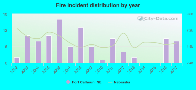 According to the data from the years 2002 - 2017 the average number of fires per year is 6. The highest number of fire incidents - 16 took place in 2006, and the least - 0 in 2014. The data has a growing trend.
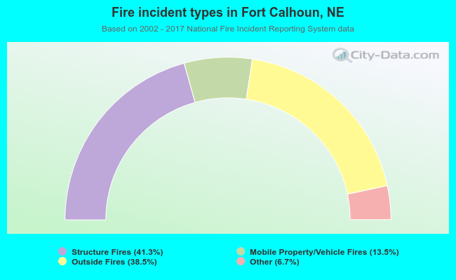 When looking into fire subcategories, the most reports belonged to: Structure Fires (41.3%), and Outside Fires (38.5%).
| Most common first names in Fort Calhoun, NE among deceased individuals | ||
| Name | Count | Lived (average) |
|---|---|---|
| William | 14 | 74.9 years |
| John | 13 | 71.5 years |
| Dorothy | 12 | 81.4 years |
| Mary | 11 | 75.9 years |
| Robert | 7 | 68.2 years |
| Helen | 7 | 83.3 years |
| George | 6 | 68.2 years |
| Richard | 6 | 73.9 years |
| Anna | 5 | 91.2 years |
| Clara | 5 | 86.4 years |
| Most common last names in Fort Calhoun, NE among deceased individuals | ||
| Last name | Count | Lived (average) |
|---|---|---|
| Smith | 8 | 77.2 years |
| Kruse | 6 | 83.3 years |
| Miller | 6 | 71.2 years |
| Wiese | 6 | 72.3 years |
| Jipp | 5 | 76.6 years |
| Stratbucker | 5 | 79.2 years |
| Hineline | 4 | 72.8 years |
| Mehrens | 4 | 90.3 years |
| Ohrt | 4 | 84.0 years |
| Petersen | 4 | 76.8 years |
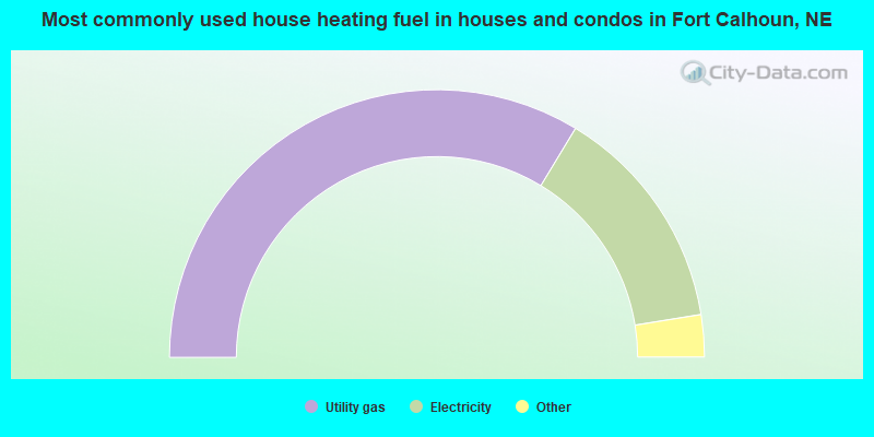
- 67.6%Utility gas
- 27.7%Electricity
- 3.5%Other fuel
- 1.2%Bottled, tank, or LP gas
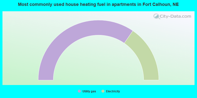
- 69.3%Utility gas
- 30.7%Electricity
Fort Calhoun compared to Nebraska state average:
- Unemployed percentage below state average.
- Black race population percentage significantly below state average.
- Foreign-born population percentage significantly below state average.
- Length of stay since moving in significantly above state average.
- Number of rooms per house below state average.
- House age below state average.

|
|
Total of 8 patent applications in 2008-2024.