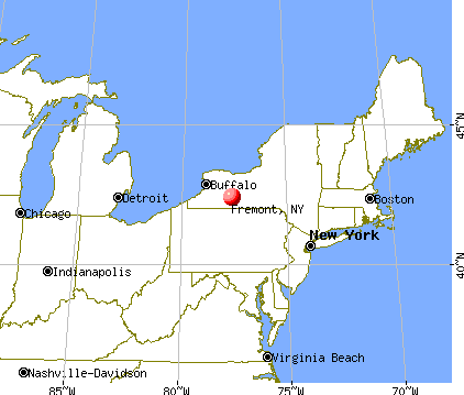
Fremont, New York
Submit your own pictures of this town and show them to the world
- OSM Map
- General Map
- Google Map
- MSN Map
Population change since 2000: -0.7%
| Males: 712 | |
| Females: 669 |
| Median resident age: | 46.7 years |
| New York median age: | 40.7 years |
Zip codes: 14843.
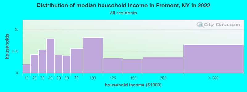
| Fremont: | $57,101 |
| NY: | $79,557 |
Estimated per capita income in 2022: $41,619 (it was $18,087 in 2000)
Fremont town income, earnings, and wages data
Estimated median house or condo value in 2022: $287,871 (it was $94,700 in 2000)
| Fremont: | $287,871 |
| NY: | $400,400 |
Mean prices in 2022: all housing units: $270,318; detached houses: $296,292; townhouses or other attached units: $279,664; in 2-unit structures: $506,859; in 3-to-4-unit structures: $161,643; in 5-or-more-unit structures: $372,499; mobile homes: $81,693
Detailed information about poverty and poor residents in Fremont, NY
Compare current foreclosures near Fremont, NY:
| Photo | Address | Area | Beds / Baths | Price | Details |
|---|---|---|---|---|---|

|
#1
Wawanda Ave
Liberty, NY 12754
|
1,000 sq. feet
|
1 baths 2 beds |
$54,900
|
show details |

|
#2
Equinunk Creek Rd
Lakewood, PA 18439
|
1,650 sq. feet
|
2 baths 4 beds |
show details | |

|
#3
Church St
East Branch, NY 13756
|
- sq. feet
|
- baths - beds |
$29,900
|
show details |

|
#4
Vestal Ave
Hancock, NY 13783
|
2,700 sq. feet
|
2 baths 4 beds |
show details | |

|
#5
State Route 55
Liberty, NY 12754
|
1,846 sq. feet
|
2 baths 4 beds |
show details | |

|
#6
Steiner Rd
Damascus, PA 18415
|
2,532 sq. feet
|
2 baths 4 beds |
show details | |

|
#7
Carney Rd
Honesdale, PA 18431
|
1,632 sq. feet
|
2 baths 4 beds |
show details | |

|
#8
Pflaster Rd
Damascus, PA 18415
|
1,456 sq. feet
|
2 baths 3 beds |
show details | |

|
#9
Wild Acres Dr
Honesdale, PA 18431
|
2,880 sq. feet
|
2 baths 4 beds |
show details | |

|
#10
Dwyer Ave
Liberty, NY 12754
|
912 sq. feet
|
1 baths 3 beds |
show details |
| Photo | Address | Area | Beds / Baths | Price | Details |
|---|---|---|---|---|---|

|
#11
Liberty St
Liberty, NY 12754
|
2,076 sq. feet
|
2 baths 4 beds |
show details | |

|
#12
West St
Liberty, NY 12754
|
- sq. feet
|
- baths - beds |
show details | |

|
#13
Raspberry Park Rd
Long Eddy, NY 12760
|
- sq. feet
|
- baths - beds |
show details | |

|
#14
County Highway 17
Hancock, NY 13783
|
- sq. feet
|
- baths - beds |
show details | |

|
#15
Wallerville Rd
Lake Como, PA 18437
|
- sq. feet
|
- baths - beds |
show details | |

|
#16
Old Route 17
Roscoe, NY 12776
|
- sq. feet
|
- baths - beds |
show details | |

|
#17
Campbell Rd
Livingston Manor, NY 12758
|
- sq. feet
|
- baths - beds |
show details | |

|
#18
Rockland Rd
Roscoe, NY 12776
|
- sq. feet
|
- baths - beds |
show details | |

|
#19
Route 52
Youngsville, NY 12791
|
- sq. feet
|
- baths - beds |
show details | |

|
#20
Bridge Road
Liberty, NY 12754
|
- sq. feet
|
- baths - beds |
show details |
| Photo | Address | Area | Beds / Baths | Price | Details |
|---|---|---|---|---|---|

|
Check over 1 million property listings on Foreclosure.com!
|
browse all offers | |||
| Photo | Address | Area | Beds / Baths | Price | Details |
|---|

- 1,25690.9%White alone
- 483.5%Hispanic
- 312.2%Black alone
- 261.9%Two or more races
- 120.9%Asian alone
- 30.2%Native Hawaiian and Other
Pacific Islander alone - 30.2%Other race alone
- 20.1%American Indian alone
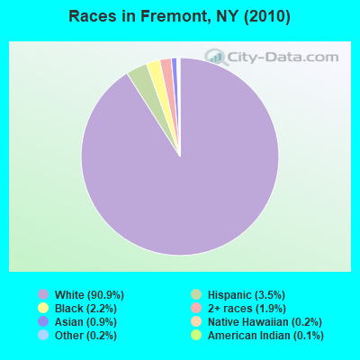
Races in Fremont detailed stats: ancestries, foreign born residents, place of birth
 Recent articles from our blog. Our writers, many of them Ph.D. graduates or candidates, create easy-to-read articles on a wide variety of topics.


Latest news from Fremont, NY collected exclusively by city-data.com from local newspapers, TV, and radio stations
Ancestries: German (30.6%), Irish (22.6%), Italian (10.9%), English (8.3%), Polish (5.8%), United States (3.8%).
Current Local Time: EST time zone
Land area: 50.3 square miles.
Population density: 27 people per square mile (very low).
46 residents are foreign born (1.8% Europe, 0.8% Latin America, 0.7% Asia).
| This town: | 3.3% |
| New York: | 20.4% |
| Fremont town: | 1.7% ($1,647) |
| New York: | 1.9% ($2,847) |
Nearest city with pop. 50,000+: Scranton, PA  (44.9 miles , pop. 76,415).
Nearest city with pop. 200,000+: Newark, NJ (89.6 miles , pop. 273,546).
Nearest city with pop. 1,000,000+: Bronx, NY (92.7 miles , pop. 1,332,650).
Nearest cities:
), ), ), ), ), Latitude: 41.86 N, Longitude: 75.04 W
Area code commonly used in this area: 845

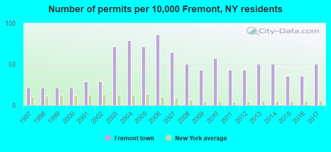
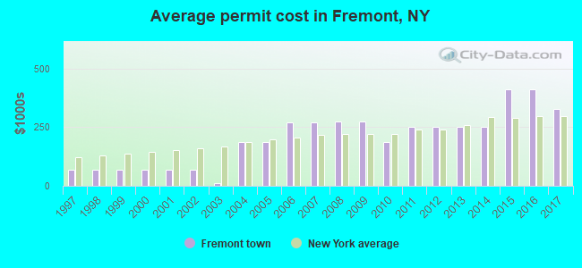
Single-family new house construction building permits:
- 2017: 7 buildings, average cost: $327,000
- 2016: 5 buildings, average cost: $412,800
- 2015: 5 buildings, average cost: $412,800
- 2014: 7 buildings, average cost: $251,800
- 2013: 7 buildings, average cost: $251,800
- 2012: 6 buildings, average cost: $251,800
- 2011: 6 buildings, average cost: $251,800
- 2010: 8 buildings, average cost: $187,500
- 2009: 6 buildings, average cost: $273,000
- 2008: 7 buildings, average cost: $273,000
- 2007: 9 buildings, average cost: $270,000
- 2006: 12 buildings, average cost: $270,000
- 2005: 10 buildings, average cost: $187,300
- 2004: 11 buildings, average cost: $187,300
- 2003: 10 buildings, average cost: $10,500
- 2002: 4 buildings, average cost: $68,300
- 2001: 4 buildings, average cost: $68,300
- 2000: 3 buildings, average cost: $68,300
- 1999: 3 buildings, average cost: $68,300
- 1998: 3 buildings, average cost: $68,300
- 1997: 3 buildings, average cost: $68,300
| Here: | 3.9% |
| New York: | 4.4% |
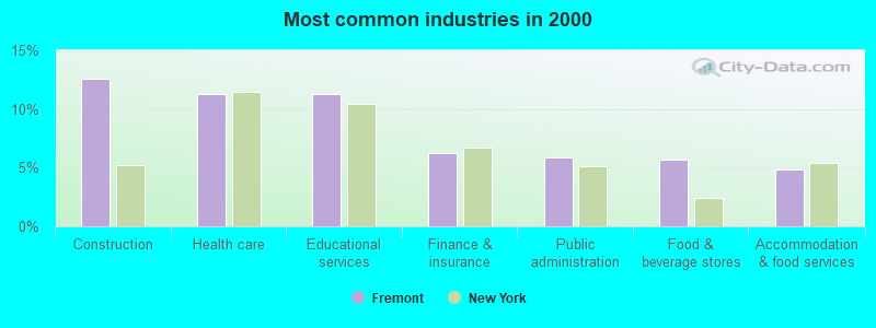
- Construction (12.6%)
- Health care (11.2%)
- Educational services (11.2%)
- Finance & insurance (6.2%)
- Public administration (5.9%)
- Food & beverage stores (5.7%)
- Accommodation & food services (4.9%)
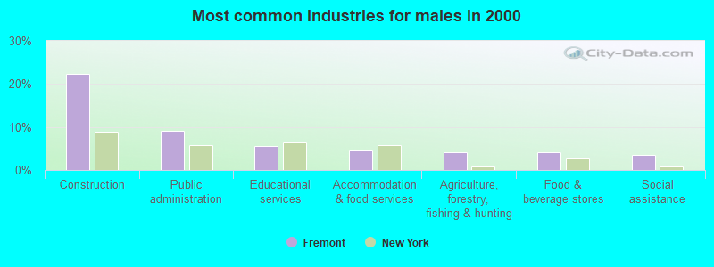
- Construction (22.3%)
- Public administration (9.2%)
- Educational services (5.6%)
- Accommodation & food services (4.5%)
- Agriculture, forestry, fishing & hunting (4.2%)
- Food & beverage stores (4.2%)
- Social assistance (3.6%)
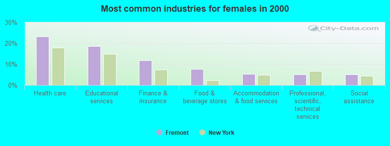
- Health care (23.2%)
- Educational services (18.5%)
- Finance & insurance (12.0%)
- Food & beverage stores (7.7%)
- Accommodation & food services (5.4%)
- Professional, scientific, technical services (5.0%)
- Social assistance (5.0%)

- Registered nurses (4.9%)
- Other sales and related occupations, including supervisors (4.7%)
- Other management occupations, except farmers and farm managers (4.7%)
- Building and grounds cleaning and maintenance occupations (4.5%)
- Material recording, scheduling, dispatching, and distributing workers (3.9%)
- Preschool, kindergarten, elementary, and middle school teachers (3.5%)
- Driver/sales workers and truck drivers (3.4%)
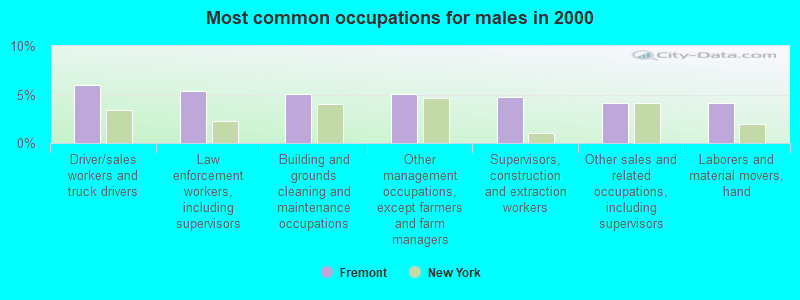
- Driver/sales workers and truck drivers (5.9%)
- Law enforcement workers, including supervisors (5.3%)
- Building and grounds cleaning and maintenance occupations (5.0%)
- Other management occupations, except farmers and farm managers (5.0%)
- Supervisors, construction and extraction workers (4.7%)
- Other sales and related occupations, including supervisors (4.2%)
- Laborers and material movers, hand (4.2%)
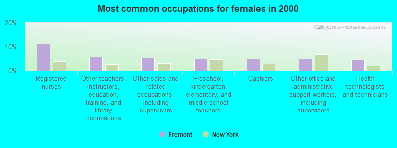
- Registered nurses (11.2%)
- Other teachers, instructors, education, training, and library occupations (5.8%)
- Other sales and related occupations, including supervisors (5.4%)
- Preschool, kindergarten, elementary, and middle school teachers (5.0%)
- Cashiers (5.0%)
- Other office and administrative support workers, including supervisors (5.0%)
- Health technologists and technicians (4.6%)
Average climate in Fremont, New York
Based on data reported by over 4,000 weather stations


Tornado activity:
Fremont-area historical tornado activity is slightly above New York state average. It is 52% smaller than the overall U.S. average.
On 5/31/1998, a category F3 (max. wind speeds 158-206 mph) tornado 15.3 miles away from the Fremont town center injured 12 people and caused $3 million in damages.
On 5/31/1998, a category F3 tornado 38.9 miles away from the town center injured 2 people and caused $1 million in damages.
Earthquake activity:
Fremont-area historical earthquake activity is significantly above New York state average. It is 67% smaller than the overall U.S. average.On 10/7/1983 at 10:18:46, a magnitude 5.3 (5.1 MB, 5.3 LG, 5.1 ML, Class: Moderate, Intensity: VI - VII) earthquake occurred 149.0 miles away from the city center
On 4/20/2002 at 10:50:47, a magnitude 5.3 (5.3 ML, Depth: 3.0 mi) earthquake occurred 195.5 miles away from the city center
On 4/20/2002 at 10:50:47, a magnitude 5.2 (5.2 MB, 4.2 MS, 5.2 MW, 5.0 MW) earthquake occurred 193.5 miles away from the city center
On 8/23/2011 at 17:51:04, a magnitude 5.8 (5.8 MW, Depth: 3.7 mi) earthquake occurred 313.5 miles away from Fremont center
On 1/16/1994 at 01:49:16, a magnitude 4.6 (4.6 MB, 4.6 LG, Depth: 3.1 mi, Class: Light, Intensity: IV - V) earthquake occurred 117.9 miles away from Fremont center
On 6/17/1991 at 08:53:16, a magnitude 4.1 (4.0 MB, 4.0 LG, Depth: 3.1 mi) earthquake occurred 56.4 miles away from the city center
Magnitude types: regional Lg-wave magnitude (LG), body-wave magnitude (MB), local magnitude (ML), surface-wave magnitude (MS), moment magnitude (MW)
Natural disasters:
The number of natural disasters in Sullivan County (29) is a lot greater than the US average (15).Major Disasters (Presidential) Declared: 19
Emergencies Declared: 9
Causes of natural disasters: Floods: 11, Storms: 11, Hurricanes: 5, Snowstorms: 3, Blizzards: 2, Heavy Rain: 1, Power Outage: 1, Tornado: 1, Tropical Depression: 1, Tropical Storm: 1, Water Shortage: 1, Winter Storm: 1, Other: 3 (Note: some incidents may be assigned to more than one category).

Colleges/universities with over 2000 students nearest to Fremont:
- SUNY College of Technology at Delhi (about 29 miles; Delhi, NY; Full-time enrollment: 2,911)
- SUNY Oneonta (about 42 miles; Oneonta, NY; FT enrollment: 6,081)
- Marywood University (about 43 miles; Scranton, PA; FT enrollment: 2,959)
- Orange County Community College (about 44 miles; Middletown, NY; FT enrollment: 4,742)
- University of Scranton (about 45 miles; Scranton, PA; FT enrollment: 5,488)
- Ulster County Community College (about 47 miles; Stone Ridge, NY; FT enrollment: 2,207)
- SUNY Broome Community College (about 49 miles; Binghamton, NY; FT enrollment: 4,969)
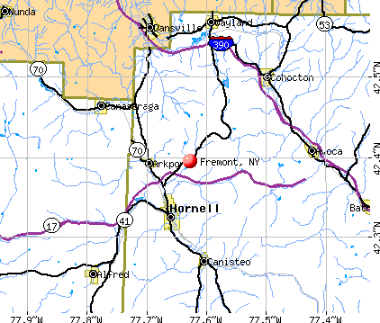
Points of interest:
Notable locations in Fremont: Tennanah Lake Golf and Tennis Club (A), Long Eddy Fire District (B). Display/hide their locations on the map
Church in Fremont: Saint Marys Church (A). Display/hide its location on the map
Cemeteries: Saint Mary's Cemetery (1), Basket Cemetery (2). Display/hide their locations on the map
Lakes and reservoirs: Mud Pond (A), Lake Muskoday (B), Reichmann Pond (C), Tennanah Lake (D), Crystal Lake (E), Anawanda Lake (F), Basket Lake (G), Dascher Pond (H). Display/hide their locations on the map
Streams, rivers, and creeks: Pea Brook (A), Basket Creek (B), Hoolihan Brook (C), Hankins Creek (D). Display/hide their locations on the map
| This town: | 2.2 people |
| New York: | 2.6 people |
| This town: | 62.1% |
| Whole state: | 63.5% |
| This town: | 6.8% |
| Whole state: | 6.8% |
Likely homosexual households (counted as self-reported same-sex unmarried-partner households)
- Lesbian couples: 0.8% of all households
- Gay men: 0.8% of all households
| This town: | 15.7% |
| Whole state: | 14.6% |
| This town: | 4.5% |
| Whole state: | 7.4% |
For population 15 years and over in Fremont:
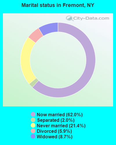
- Never married: 21.4%
- Now married: 62.0%
- Separated: 2.0%
- Widowed: 8.7%
- Divorced: 5.9%
For population 25 years and over in Fremont:
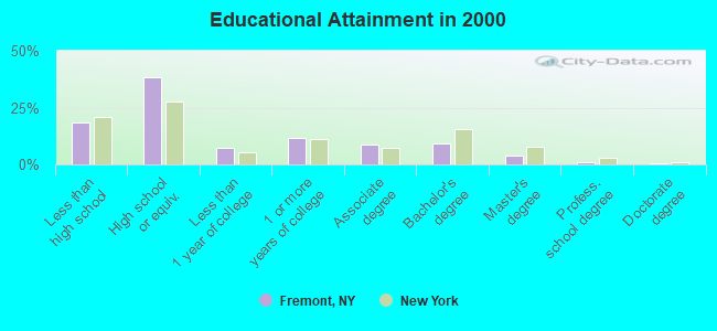
- High school or higher: 81.5%
- Bachelor's degree or higher: 15.0%
- Graduate or professional degree: 5.5%
- Unemployed: 2.9%
- Mean travel time to work (commute): 33.4 minutes
| Here: | 11.6 |
| New York average: | 14.2 |
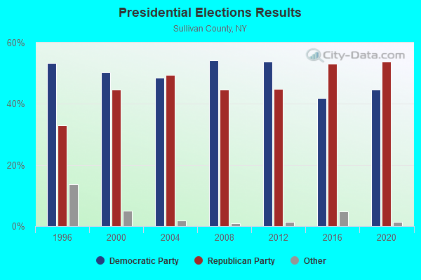
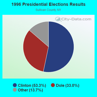
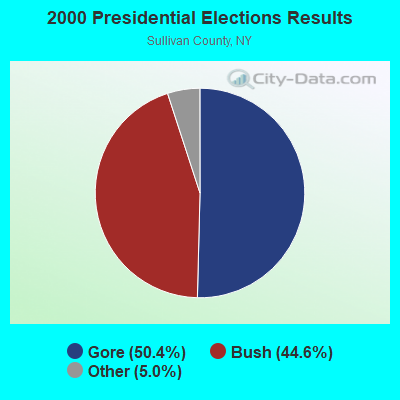
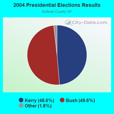

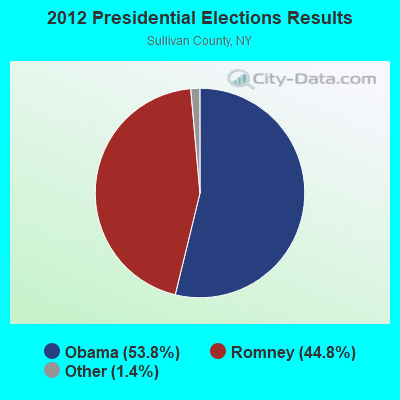
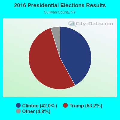
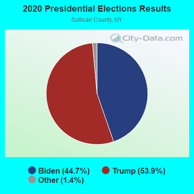
Graphs represent county-level data. Detailed 2008 Election Results
Religion statistics for Fremont, NY (based on Sullivan County data)
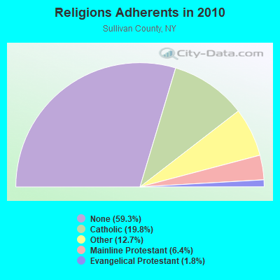
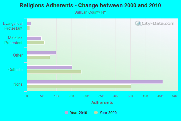
| Religion | Adherents | Congregations |
|---|---|---|
| Catholic | 15,352 | 21 |
| Other | 9,817 | 31 |
| Mainline Protestant | 4,947 | 44 |
| Evangelical Protestant | 1,399 | 18 |
| Orthodox | 60 | 2 |
| None | 45,972 | - |
Food Environment Statistics:
| Sullivan County: | 4.06 / 10,000 pop. |
| New York: | 4.13 / 10,000 pop. |
| This county: | 0.13 / 10,000 pop. |
| New York: | 0.06 / 10,000 pop. |
| Here: | 2.22 / 10,000 pop. |
| New York: | 0.92 / 10,000 pop. |
| Sullivan County: | 5.63 / 10,000 pop. |
| State: | 1.68 / 10,000 pop. |
| This county: | 10.99 / 10,000 pop. |
| New York: | 8.82 / 10,000 pop. |
| Here: | 9.4% |
| New York: | 8.2% |
| Sullivan County: | 24.1% |
| State: | 23.8% |
| Here: | 16.4% |
| New York: | 15.6% |
Strongest AM radio stations in Fremont:
- WDLA (1270 AM; 5 kW; WALTON, NY; Owner: BANJO COMMUNICATIONS GROUP, INC.)
- WMCA (570 AM; 50 kW; NEW YORK, NY; Owner: SALEM MEDIA OF NEW YORK, LLC)
- WABC (770 AM; 50 kW; NEW YORK, NY; Owner: WABC-AM RADIO, INC.)
- WGY (810 AM; 50 kW; SCHENECTADY, NY; Owner: CLEAR CHANNEL BROADCASTING LICENSES, INC.)
- WOR (710 AM; 50 kW; NEW YORK, NY; Owner: BUCKLEY BROADCASTING CORPORATION)
- WFAN (660 AM; 50 kW; NEW YORK, NY; Owner: INFINITY BROADCASTING OPERATIONS, INC.)
- WWJZ (640 AM; 50 kW; MOUNT HOLLY, NJ; Owner: ABC, INC.)
- WINS (1010 AM; 50 kW; NEW YORK, NY; Owner: INFINITY BROADCASTING OPERATIONS, INC.)
- WCBS (880 AM; 50 kW; NEW YORK, NY; Owner: INFINITY BROADCASTING OPERATIONS, INC.)
- WEPN (1050 AM; 50 kW; NEW YORK, NY; Owner: NEW YORK AM RADIO, LLC)
- WSNR (620 AM; 20 kW; JERSEY CITY, NJ)
- WBBR (1130 AM; 50 kW; NEW YORK, NY; Owner: BLOOMBERG COMMUNICATIONS INC.)
- WADO (1280 AM; 50 kW; NEW YORK, NY; Owner: WADO-AM LICENSE CORP.)
Strongest FM radio stations in Fremont:
- WJFF (90.5 FM; JEFFERSONVILLE, NY; Owner: RADIO CATSKILL)
- WPDA (106.1 FM; JEFFERSONVILLE, NY; Owner: CUMULUS LICENSING CORP.)
- WGWR (88.1 FM; LIBERTY, NY; Owner: SOUND OF LIFE, INC.)
- WFKP (99.3 FM; ELLENVILLE, NY; Owner: CLEAR CHANNEL BROADCASTING LICENSES, INC.)
- WDLA-FM (92.1 FM; WALTON, NY; Owner: BANJO COMMUNICATIONS GROUP, INC.)
- WPGP (88.3 FM; TAFTON, PA; Owner: SOUND OF LIFE, INC.)
- WQFN (100.1 FM; FOREST CITY, PA; Owner: THE SCRANTON TIMES, L.P.)
- WDNB (102.1 FM; JEFFERSONVILLE, NY; Owner: DE WIT BROADCASTING CORP.)
- WGKR (105.3 FM; GRAND GORGE, NY; Owner: SOUND OF LIFE, INC.)
- WIYN (94.7 FM; DEPOSIT, NY; Owner: BANJO COMMUNICATIONS GROUP, INC.)
- WYCY (105.3 FM; HAWLEY, PA; Owner: DE WIT BROADCASTING CORPORATION)
- WSUL (98.3 FM; MONTICELLO, NY; Owner: REYNOLDS COMMUNICATIONS, INC.)
- WAMK (90.9 FM; KINGSTON, NY; Owner: W A M C)
- WDNH-FM (95.3 FM; HONESDALE, PA; Owner: DE WIT BROADCASTING CORPORATION)
- WFGB (89.7 FM; KINGSTON, NY; Owner: SOUND OF LIFE, INC.)
- WCWI (94.3 FM; CARBONDALE, PA; Owner: CITADEL BROADCASTING COMPANY)
- WEZX (106.9 FM; SCRANTON, PA; Owner: THE SCRANTON TIMES, L.P.)
- WPDH (101.5 FM; POUGHKEEPSIE, NY; Owner: CUMULUS LICENSING CORP.)
- WHWK (98.1 FM; BINGHAMTON, NY; Owner: CITADEL BROADCASTING COMPANY)
- WGGY (101.3 FM; SCRANTON, PA; Owner: ENTERCOM WILKES-BARRE SCRANTON, LLC)
TV broadcast stations around Fremont:
- W30AZ (Channel 30; LIBERTY, NY; Owner: JOHN MESTER INCOME FAMILY TRUST)
- National Bridge Inventory (NBI) Statistics
- 13Number of bridges
- 151ft / 46.5mTotal length
- $22,153,000Total costs
- 3,640Total average daily traffic
- 448Total average daily truck traffic
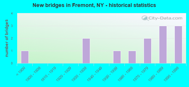
- New bridges - historical statistics
- 1Before 1900
- 21930-1939
- 11950-1959
- 11960-1969
- 21970-1979
- 31980-1989
- 31990-1999
FCC Registered Broadcast Land Mobile Towers:
2- NY05432-Highland 3, State Route 97 (Lat: 41.524444 Lon: -74.868333), Type: Tower, Structure height: 59 m, Call Sign: WQHK544,
Assigned Frequencies: 855.462 MHz, 855.737 MHz, 856.262 MHz, 856.437 MHz, 856.737 MHz, 856.937 MHz, 857.212 MHz, 857.262 MHz, 857.437 MHz, 857.937 MHz... (+7 more), Grant Date: 08/22/2007, Expiration Date: 08/22/2017, Cancellation Date: 01/14/2011, Registrant: Nys Dhses Office Of Interoperable And Emergency Communications, State Office Campus Building 22, 1220 Washington Ave, Albany, NY 12226, Phone: (518) 322-4912, Fax: (518) 322-4975, Email:
- CSSUL-18, Johnston Road (Lat: 41.863333 Lon: -75.092500), Type: Upole, Structure height: 18.3 m, Call Sign: WQHP406,
Assigned Frequencies: 854.987 MHz, 855.212 MHz, 855.462 MHz, 855.487 MHz, 855.712 MHz, 855.737 MHz, 855.962 MHz, 856.212 MHz, 856.262 MHz, 856.437 MHz... (+27 more), Grant Date: 09/25/2007, Expiration Date: 09/25/2017, Cancellation Date: 01/14/2011, Certifier: Thomas J Cowper, Registrant: Nys Dhses Office Of Interoperable And Emergency Communications, State Office Campus Building 22, 1220 Washington Ave, Albany, NY 12226, Phone: (518) 322-4912, Fax: (518) 322-4975, Email:
FCC Registered Microwave Towers:
2- FREMONT NE, Babcock Road (Lat: 42.433667 Lon: -77.568083), Type: Ltower, Structure height: 59.7 m, Call Sign: WQSY860,
Assigned Frequencies: 6197.24 MHz, 6226.89 MHz, Grant Date: 12/11/2013, Expiration Date: 12/11/2023, Cancellation Date: 01/29/2014, Certifier: John Monday, Registrant: At&t Mobility LLC, 2200 N. Greenville Ave., 1w, Richardson, TX 75082, Phone: (972) 234-7003, Fax: (972) 301-6893, Email:
- TENNANAH LK, 1273 Country Rd 93 (Lat: 41.888111 Lon: -74.955861), Type: Mast, Structure height: 54.9 m, Call Sign: WQXP570,
Assigned Frequencies: 6034.15 MHz, 6063.80 MHz, Grant Date: 05/02/2016, Expiration Date: 05/02/2026, Certifier: Edward Mcandrew, Registrant: Sullivan County Dpw, 100 North Street, Government Center, Monticello, NY 12701, Phone: (845) 807-0308, Fax: (845) 807-0335, Email:
- 68.6%Fuel oil, kerosene, etc.
- 12.5%Wood
- 9.1%Bottled, tank, or LP gas
- 8.0%Electricity
- 0.7%Utility gas
- 0.7%Coal or coke
- 0.5%Other fuel
- 71.5%Fuel oil, kerosene, etc.
- 16.3%Wood
- 7.3%Electricity
- 4.9%Bottled, tank, or LP gas
Fremont compared to New York state average:
- Unemployed percentage significantly below state average.
- Black race population percentage significantly below state average.
- Hispanic race population percentage significantly below state average.
- Median age above state average.
- Foreign-born population percentage significantly below state average.
- Renting percentage significantly below state average.
- Length of stay since moving in significantly above state average.
- Number of rooms per house significantly below state average.
- House age significantly below state average.
- Number of college students below state average.
- Percentage of population with a bachelor's degree or higher below state average.