Gifford Pinchot, Washington
Submit your own pictures of this place and show them to the world
- OSM Map
- General Map
- Google Map
- MSN Map

| Males: 52 | |
| Females: 38 |
| Median resident age: | 38.4 years |
| Washington median age: | 35.3 years |
| Gifford Pinchot: | $96,530 |
| WA: | $91,306 |
Estimated per capita income in 2022: $86,797 (it was $35,542 in 2000)
Estimated median house or condo value in 2022: $533,667 (it was $144,600 in 2000)
| Gifford Pinchot: | $533,667 |
| WA: | $569,500 |
Mean prices in 2022: all housing units: $562,307; detached houses: $625,470; townhouses or other attached units: $679,394; in 2-unit structures: $494,501; mobile homes: $338,759; occupied boats, rvs, vans, etc.: $188,126
Gifford Pinchot, WA residents, houses, and apartments details
Compare current foreclosures near your location:
| Photo | Address | Area | Beds / Baths | Price | Details |
|---|---|---|---|---|---|

|
#1
N Rhodes St
Pretty Prairie, KS 67570
|
1,725 sq. feet
|
2 baths 4 beds |
show details | |

|
#2
S Goddard Rd
Goddard, KS 67052
|
1,054 sq. feet
|
2 baths 2 beds |
show details | |

|
#3
W 21st St N
Cheney, KS 67025
|
3,190 sq. feet
|
3 baths 5 beds |
show details | |

|
#4
E Winterset St
Goddard, KS 67052
|
816 sq. feet
|
1 baths 2 beds |
show details | |

|
#5
NE Waterloo Ave
Murdock, KS 67111
|
1,220 sq. feet
|
1 baths 3 beds |
show details | |

|
#6
W 39th St S
Goddard, KS 67052
|
4,221 sq. feet
|
3 baths 3 beds |
show details | |

|
#7
N Rhodes St
Pretty Prairie, KS 67570
|
1,725 sq. feet
|
2 baths 4 beds |
show details | |

|
#8
E Arlington Rd
Haven, KS 67543
|
960 sq. feet
|
1 baths 2 beds |
show details | |

|
#9
S 391st St W
Cheney, KS 67025
|
2,558 sq. feet
|
3 baths 3 beds |
show details | |

|
#10
SE Viney Ave
Murdock, KS 67111
|
- sq. feet
|
- baths - beds |
show details |
| Photo | Address | Area | Beds / Baths | Price | Details |
|---|---|---|---|---|---|

|
#11
W 47th St S
Garden Plain, KS 67050
|
- sq. feet
|
- baths - beds |
show details | |

|
#12
N 189th Cir W
Colwich, KS 67030
|
- sq. feet
|
- baths - beds |
show details | |

|
#13
N Main St
Goddard, KS 67052
|
- sq. feet
|
- baths - beds |
show details | |

|
#14
Martens Ct
Goddard, KS 67052
|
- sq. feet
|
- baths - beds |
show details | |

|
#15
E 4th Ave Apt 1
Cheney, KS 67025
|
- sq. feet
|
- baths - beds |
show details | |

|
#16
W Maple St Lot D
Goddard, KS 67052
|
- sq. feet
|
- baths - beds |
show details | |

|
#17
W Main St
Mount Hope, KS 67108
|
- sq. feet
|
- baths - beds |
show details | |

|
#18
S 339th St W
Cheney, KS 67025
|
- sq. feet
|
- baths - beds |
show details | |

|
#19
E Casey Dr
Goddard, KS 67052
|
- sq. feet
|
- baths - beds |
show details | |

|
Check over 1 million property listings on Foreclosure.com!
|
browse all offers | |||

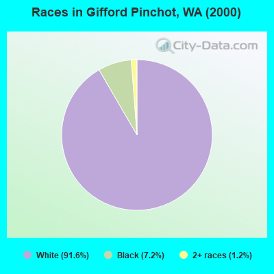
- 7691.6%White alone
- 67.2%Black alone
- 11.2%Two or more races
 Recent articles from our blog. Our writers, many of them Ph.D. graduates or candidates, create easy-to-read articles on a wide variety of topics.
Current Local Time: PST time zone
Land area: 1376.8 square miles.
Population density: 0.07 people per square mile (very low).

| Gifford Pinchot CCD: | 1.0% ($1,429) |
| Washington: | 1.2% ($1,915) |
Nearest city with pop. 50,000+: Vancouver, WA  (43.1 miles , pop. 143,560).
Nearest city with pop. 200,000+: Portland, OR (49.8 miles , pop. 529,121).
Nearest city with pop. 1,000,000+: Los Angeles, CA (849.2 miles , pop. 3,694,820).
Nearest cities:
), ), ), Latitude: 46.06 N, Longitude: 121.95 W

| Here: | 5.2% |
| Washington: | 4.6% |
Average climate in Gifford Pinchot, Washington
Based on data reported by over 4,000 weather stations


Earthquake activity:
Gifford Pinchot-area historical earthquake activity is significantly above Washington state average. It is 1554% greater than the overall U.S. average.On 4/13/1949 at 19:55:42, a magnitude 7.0 (7.0 UK, Class: Major, Intensity: VIII - XII) earthquake occurred 86.4 miles away from Gifford Pinchot center, causing $80,000,000 total damage
On 2/28/2001 at 18:54:32, a magnitude 6.8 (6.5 MB, 6.6 MS, 6.8 MW, Class: Strong, Intensity: VII - IX) earthquake occurred 77.3 miles away from Gifford Pinchot center, causing $2,000,000,000 total damage and $305,000,000 insured losses
On 2/28/2001 at 18:54:32, a magnitude 6.8 (6.8 MD, Depth: 32.2 mi) earthquake occurred 83.9 miles away from the city center
On 4/29/1965 at 15:28:43, a magnitude 6.6 (6.6 UK) earthquake occurred 88.9 miles away from the city center, causing $28,000,000 total damage
On 1/31/1922 at 13:17:28, a magnitude 7.6 (7.6 UK) earthquake occurred 412.5 miles away from Gifford Pinchot center
On 11/8/1980 at 10:27:34, a magnitude 7.2 (6.2 MB, 7.2 MS, 7.2 MW, 7.0 ML) earthquake occurred 362.0 miles away from Gifford Pinchot center
Magnitude types: body-wave magnitude (MB), duration magnitude (MD), local magnitude (ML), surface-wave magnitude (MS), moment magnitude (MW)
Natural disasters:
The number of natural disasters in Skamania County (20) is greater than the US average (15).Major Disasters (Presidential) Declared: 16
Emergencies Declared: 2
Causes of natural disasters: Floods: 12, Mudslides: 9, Landslides: 8, Winter Storms: 8, Storms: 5, Fires: 2, Winds: 2, Earthquake: 1, Heavy Rain: 1, Hurricane: 1, Snow: 1, Tornado: 1, Volcanic Eruption: 1, Other: 1 (Note: some incidents may be assigned to more than one category).
Colleges/universities with over 2000 students nearest to Gifford Pinchot:
- Mt Hood Community College (about 44 miles; Gresham, OR; Full-time enrollment: 11,847)
- Clark College (about 45 miles; Vancouver, WA; FT enrollment: 9,330)
- Concordia University-Portland (about 48 miles; Portland, OR; FT enrollment: 3,996)
- Lower Columbia College (about 48 miles; Longview, WA; FT enrollment: 2,595)
- University of Portland (about 51 miles; Portland, OR; FT enrollment: 4,030)
- Portland State University (about 52 miles; Portland, OR; FT enrollment: 21,450)
- Lewis & Clark College (about 55 miles; Portland, OR; FT enrollment: 2,864)
Public elementary/middle school in Gifford Pinchot:
- EVERGREEN SCHOOL (Location: 3342 ADDY-GIFFORD RD, Grades: KG-6)
Points of interest:
Notable locations in Gifford Pinchot: South Campground (A), Spencer Butte Lookout (B), Smith Creek Butte Lookout (C), Sunrise Peak Lookout (D), Little Goose Campground (E), Hickmans Cabin (F), Oklahoma Campground (G), Council Lake Campground (H), Home Guard Station (I), Government Spring Guard Station (J), Cold Spring Campground (K), Smoky Creek Campground (L), Peterson Guard Station (M), Lake Camp (N), Takhlakh Forest Camp (O), Horseshoe Lake Forest Camp (P), Cat Creek Guard Station (Q), Cat Creek Campground (R), Tillicum Campground (S), Sled Camp (T). Display/hide their locations on the map
Lakes, reservoirs, and swamps: Shovel Lake (A), Green Mountain Lake (B), Lake Kwaddis (C), Clear Lake (D), Saint Charles Lake (E), Lake Sahalee Tyee (F), Grizzly Lake (G), Meadow Lake (H). Display/hide their locations on the map
Streams, rivers, and creeks: Bean Creek (A), Big Hollow Creek (B), Big Huckleberry Creek (C), Black Creek (D), Bolin Creek (E), Boulder Creek (F), Bourbon Creek (G), Cabin Creek (H), Calamity Creek (I). Display/hide their locations on the map
Parks in Gifford Pinchot include: Fringe Viewpoint (1), Mount Saint Helens Viewpoint (2), Wind River Natural Area (3), Mount Saint Helens National Volcanic Monument (4), Cedar Flats Natural Area (5), Upper Wind River Winter Sports Area (6), Sister Rocks Research Natural Area (7), Smith Creek Viewpoint (8), Donnybrook Viewpoint (9). Display/hide their locations on the map
| This place: | 2.7 people |
| Washington: | 2.5 people |
| This place: | 41.9% |
| Whole state: | 66.5% |
| This place: | 12.9% |
| Whole state: | 6.1% |
No gay or lesbian households reported
| This place: | 2.5% |
| Whole state: | 10.6% |
| This place: | 2.5% |
| Whole state: | 4.6% |
For population 15 years and over in Gifford Pinchot:
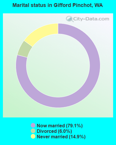
- Never married: 14.9%
- Now married: 79.1%
- Separated: 0.0%
- Widowed: 0.0%
- Divorced: 6.0%
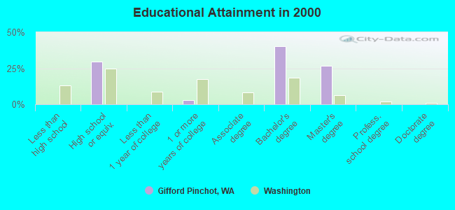
For population 25 years and over in Gifford Pinchot:
- High school or higher: 100.0%
- Bachelor's degree or higher: 67.2%
- Graduate or professional degree: 26.9%
- Mean travel time to work (commute): 21.4 minutes
| Here: | 8.2 |
| Washington average: | 11.3 |
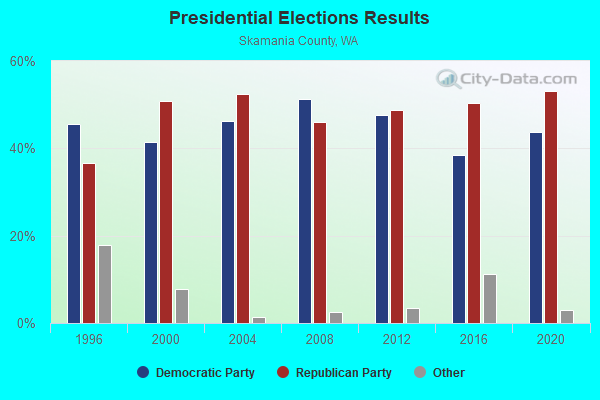
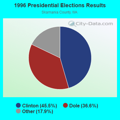
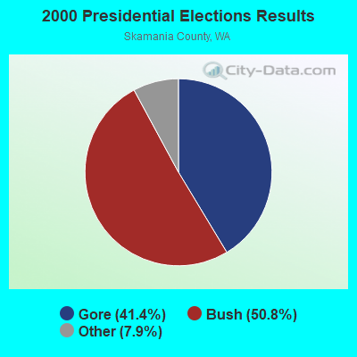
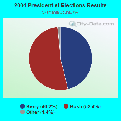
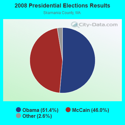
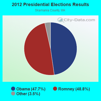
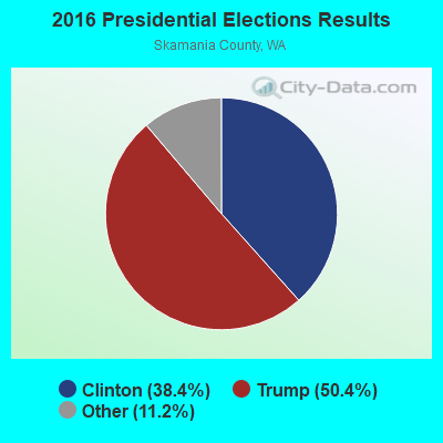
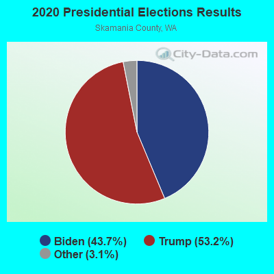
Graphs represent county-level data. Detailed 2008 Election Results
Religion statistics for Gifford Pinchot, WA (based on Skamania County data)
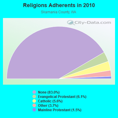
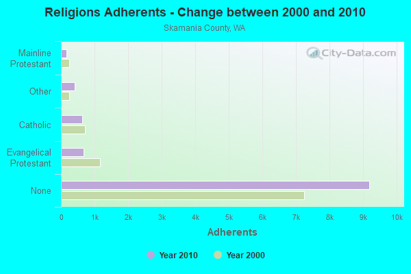
| Religion | Adherents | Congregations |
|---|---|---|
| Evangelical Protestant | 679 | 10 |
| Catholic | 625 | 1 |
| Other | 414 | 2 |
| Mainline Protestant | 163 | 2 |
| None | 9,185 | - |
Food Environment Statistics:
| Here: | 1.87 / 10,000 pop. |
| Washington: | 2.06 / 10,000 pop. |
| Skamania County: | 0.93 / 10,000 pop. |
| State: | 1.18 / 10,000 pop. |
| Skamania County: | 4.67 / 10,000 pop. |
| Washington: | 2.67 / 10,000 pop. |
| Skamania County: | 6.54 / 10,000 pop. |
| Washington: | 8.26 / 10,000 pop. |
| Here: | 7.8% |
| Washington: | 7.7% |
| Skamania County: | 32.1% |
| Washington: | 25.7% |
| Here: | 15.2% |
| Washington: | 13.9% |
Strongest AM radio stations in Gifford Pinchot:
- KPAM (860 AM; 50 kW; TROUTDALE, OR; Owner: PAMPLIN BROADCASTING-OREGON, INC.)
- KPOJ (620 AM; 50 kW; PORTLAND, OR; Owner: CITICASTERS LICENSES, L.P.)
- KOTK (1080 AM; 50 kW; PORTLAND, OR; Owner: FISHER BROADCASTING - PORTLAND RADIO, L.L.C.)
- KXL (750 AM; 50 kW; PORTLAND, OR; Owner: ROSE CITY RADIO CORPORATION)
- KKAD (1550 AM; 50 kW; VANCOUVER, WA; Owner: PAMPLIN BROADCASTING-WASHINGTON, INC)
- KEX (1190 AM; 50 kW; PORTLAND, OR; Owner: CITICASTERS LICENSES, L.P.)
- KKSN (1520 AM; 50 kW; OREGON CITY, OR; Owner: ENTERCOM PORTLAND LICENSE, LLC)
- KJR (950 AM; 50 kW; SEATTLE, WA)
- KIRO (710 AM; 50 kW; SEATTLE, WA; Owner: ENTERCOM SEATTLE LICENSE, LLC)
- KTTH (770 AM; 50 kW; SEATTLE, WA; Owner: ENTERCOM SEATTLE LICENSE, LLC)
- KGNW (820 AM; 50 kW; BURIEN-SEATTLE, WA; Owner: INSPIRATION MEDIA, INC.)
- KFXX (910 AM; 10 kW; VANCOUVER, WA; Owner: ENTERCOM PORTLAND LICENSE, LLC (DE))
- KYCW (1090 AM; 50 kW; SEATTLE, WA; Owner: INFINITY RADIO SUBSIDIARY OPERATIONS INC.)
Strongest FM radio stations in Gifford Pinchot:
- K273AI (102.5 FM; ARIEL, WA; Owner: CALVARY CHAPEL OF TWIN FALLS, INC.)
- KXXO (96.1 FM; OLYMPIA, WA; Owner: 3 CITIES, INC.)
- KMCQ (104.5 FM; THE DALLES, OR; Owner: MID-COLUMBIA BROADCASTING, INC.)
- K215CR (90.9 FM; THE DALLES, OR; Owner: EDUCATIONAL MEDIA FOUNDATION)
- K256AC (99.1 FM; THE DALLES, OR; Owner: CATHOLIC BROADCASTING NORTHWEST, INC)
- KBNO-FM (89.3 FM; WHITE SALMON, WA; Owner: WORLD RADIO NETWORK, INC.)
- KQHR (90.1 FM; HOOD RIVER, OR; Owner: KBPS PUBLIC RADIO FOUNDATION)
- KLVP-FM (88.7 FM; CHERRYVILLE, OR; Owner: EDUCATIONAL MEDIA FOUNDATION)
- KRQT (107.1 FM; CASTLE ROCK, WA; Owner: ENTERCOM LONGVIEW LICENSE, LLC)
- KYYT (102.3 FM; GOLDENDALE, WA; Owner: HAYSTACK BROADCASTING, INC.)
- KINK (101.9 FM; PORTLAND, OR; Owner: INFINITY RADIO OPERATIONS INC.)
- KMNT (102.9 FM; CENTRALIA, WA; Owner: CITICASTERS LICENSES, L.P.)
- KKCW (103.3 FM; BEAVERTON, OR; Owner: CITICASTERS LICENSES, L.P.)
- KZRI (90.3 FM; WELCHES, OR; Owner: EDUCATIONAL MEDIA FOUNDATION)
- KRVO (105.9 FM; VANCOUVER, WA; Owner: CITICASTERS LICENSES, L.P.)
- KOPB-FM (91.5 FM; PORTLAND, OR; Owner: OREGON PUBLIC BROADCASTING)
- KPDQ-FM (93.7 FM; PORTLAND, OR; Owner: SALEM MEDIA OF OREGON, INC.)
- KKRZ (100.3 FM; PORTLAND, OR; Owner: CITICASTERS LICENSES, L.P.)
- KMHD (89.1 FM; GRESHAM, OR; Owner: MT. HOOD COMMUNITY COLLEGE DISTRICT)
- KVMX (107.5 FM; BANKS, OR; Owner: INFINITY RADIO OPERATIONS INC.)
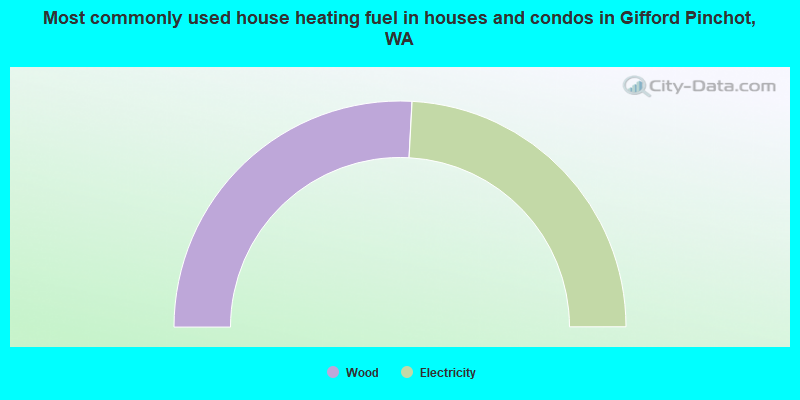
- 51.7%Wood
- 48.3%Electricity
Gifford Pinchot compared to Washington state average:
- Unemployed percentage significantly below state average.
- Black race population percentage above state average.
- Hispanic race population percentage significantly below state average.
- Median age above state average.
- Foreign-born population percentage significantly below state average.
- Renting percentage significantly below state average.
- Length of stay since moving in significantly above state average.
- Number of rooms per house significantly below state average.
- House age significantly below state average.
- Number of college students significantly below state average.
- Percentage of population with a bachelor's degree or higher significantly above state average.