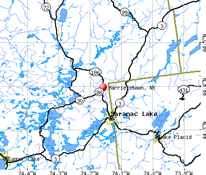
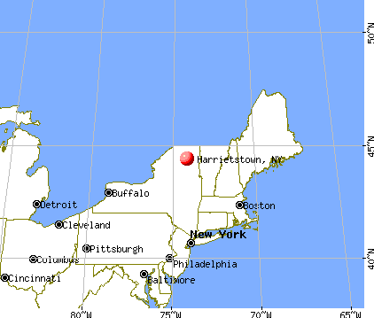
Harrietstown, New York
Submit your own pictures of this town and show them to the world
- OSM Map
- General Map
- Google Map
- MSN Map
Population change since 2000: +2.4%
 |
| Males: 2,909 | |
| Females: 2,800 |
| Median resident age: | 41.2 years |
| New York median age: | 40.7 years |
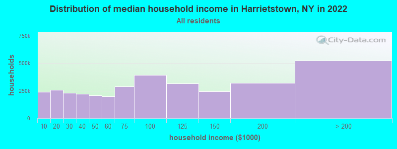
| Harrietstown: | $59,516 |
| NY: | $79,557 |
Estimated per capita income in 2022: $35,653 (it was $18,529 in 2000)
Harrietstown town income, earnings, and wages data
Estimated median house or condo value in 2022: $195,748 (it was $84,900 in 2000)
| Harrietstown: | $195,748 |
| NY: | $400,400 |
Mean prices in 2022: all housing units: $219,333; detached houses: $244,011; townhouses or other attached units: $364,147; in 2-unit structures: $197,583; in 3-to-4-unit structures: $157,263; in 5-or-more-unit structures: $800,159; mobile homes: $60,247
Detailed information about poverty and poor residents in Harrietstown, NY


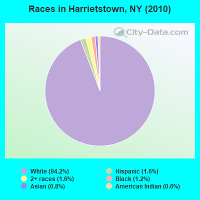
- 5,37694.2%White alone
- 911.6%Two or more races
- 931.6%Hispanic
- 661.2%Black alone
- 460.8%Asian alone
- 360.6%American Indian alone
- 10.02%Other race alone
Races in Harrietstown detailed stats: ancestries, foreign born residents, place of birth
 Recent articles from our blog. Our writers, many of them Ph.D. graduates or candidates, create easy-to-read articles on a wide variety of topics.

 | Relocating To Saranac Lake, NY (54 replies) |
| Mountains in NY (16 replies) |
| Saranac Lake (looking 2 move there) (11 replies) |
| Saranac Lake NY (2 replies) |
| Adirondacks (4 replies) |
| Any one from Saranac Lake NY (19 replies) |
Latest news from Harrietstown, NY collected exclusively by city-data.com from local newspapers, TV, and radio stations
Ancestries: Irish (26.6%), French (25.1%), English (13.8%), German (13.1%), Italian (7.7%), United States (6.4%).
Current Local Time: EST time zone
Land area: 196.8 square miles.
Population density: 29 people per square mile (very low).
159 residents are foreign born (1.6% Europe, 0.7% North America, 0.4% Latin America).
| This town: | 2.9% |
| New York: | 20.4% |
| Harrietstown town: | 2.0% ($1,676) |
| New York: | 1.9% ($2,847) |
Nearest city with pop. 50,000+: Utica, NY  (98.4 miles , pop. 60,651).
Nearest city with pop. 200,000+: Rochester, NY (188.2 miles , pop. 219,773).
Nearest city with pop. 1,000,000+: Bronx, NY (239.6 miles , pop. 1,332,650).
Nearest cities:
), ), ), ), )Latitude: 44.30 N, Longitude: 74.19 W
Area code commonly used in this area: 518

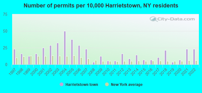
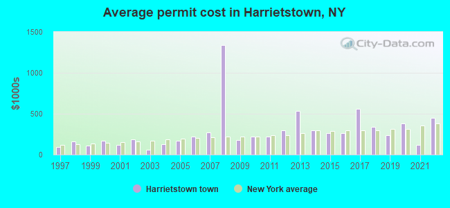
Single-family new house construction building permits:
- 2022: 13 buildings, average cost: $451,800
- 2021: 13 buildings, average cost: $114,900
- 2020: 4 buildings, average cost: $385,000
- 2019: 2 buildings, average cost: $237,500
- 2018: 12 buildings, average cost: $334,900
- 2017: 6 buildings, average cost: $558,300
- 2016: 4 buildings, average cost: $262,500
- 2015: 4 buildings, average cost: $262,500
- 2014: 8 buildings, average cost: $297,400
- 2013: 5 buildings, average cost: $532,200
- 2012: 9 buildings, average cost: $298,700
- 2011: 3 buildings, average cost: $216,700
- 2010: 3 buildings, average cost: $223,000
- 2009: 7 buildings, average cost: $175,100
- 2008: 2 buildings, average cost: $1,335,000
- 2007: 13 buildings, average cost: $269,100
- 2006: 16 buildings, average cost: $221,800
- 2005: 21 buildings, average cost: $169,700
- 2004: 28 buildings, average cost: $124,100
- 2003: 18 buildings, average cost: $59,000
- 2002: 16 buildings, average cost: $183,000
- 2001: 14 buildings, average cost: $121,400
- 2000: 9 buildings, average cost: $171,500
- 1999: 7 buildings, average cost: $109,200
- 1998: 9 buildings, average cost: $164,600
- 1997: 13 buildings, average cost: $92,900
| Here: | 4.6% |
| New York: | 4.4% |

- Health care (13.3%)
- Educational services (12.5%)
- Accommodation & food services (9.9%)
- Public administration (8.6%)
- Construction (7.7%)
- Religious, grantmaking, civic, professional, similar organizations (6.7%)
- Professional, scientific, technical services (5.3%)
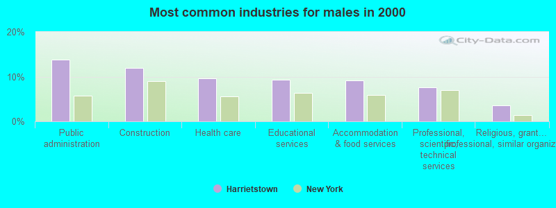
- Public administration (13.8%)
- Construction (11.9%)
- Health care (9.5%)
- Educational services (9.3%)
- Accommodation & food services (9.2%)
- Professional, scientific, technical services (7.5%)
- Religious, grantmaking, civic, professional, similar organizations (3.6%)
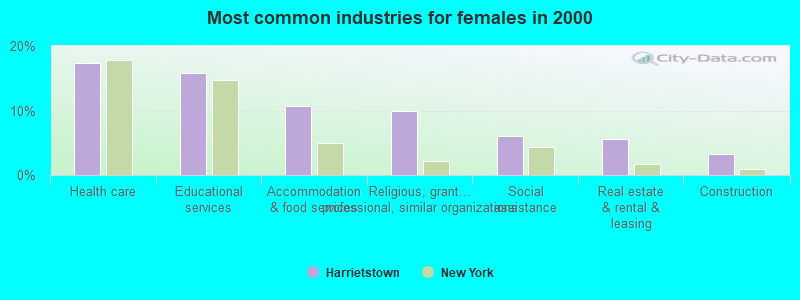
- Health care (17.4%)
- Educational services (15.9%)
- Accommodation & food services (10.7%)
- Religious, grantmaking, civic, professional, similar organizations (9.9%)
- Social assistance (6.1%)
- Real estate & rental & leasing (5.7%)
- Construction (3.3%)
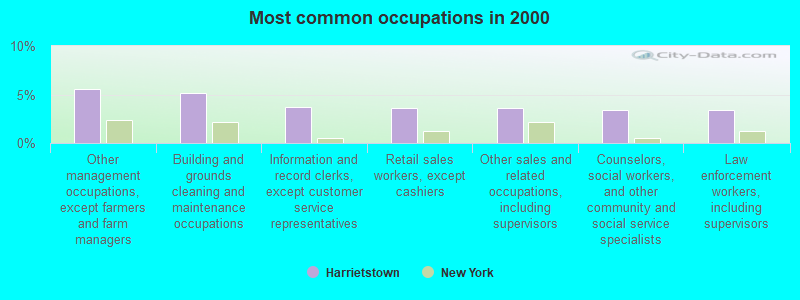
- Other management occupations, except farmers and farm managers (5.5%)
- Building and grounds cleaning and maintenance occupations (5.2%)
- Information and record clerks, except customer service representatives (3.7%)
- Retail sales workers, except cashiers (3.6%)
- Other sales and related occupations, including supervisors (3.6%)
- Counselors, social workers, and other community and social service specialists (3.4%)
- Law enforcement workers, including supervisors (3.4%)
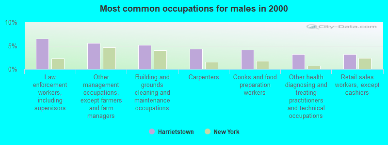
- Law enforcement workers, including supervisors (6.5%)
- Other management occupations, except farmers and farm managers (5.6%)
- Building and grounds cleaning and maintenance occupations (5.2%)
- Carpenters (4.4%)
- Cooks and food preparation workers (4.2%)
- Other health diagnosing and treating practitioners and technical occupations (3.2%)
- Retail sales workers, except cashiers (3.2%)
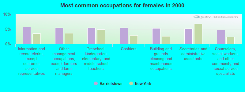
- Information and record clerks, except customer service representatives (5.8%)
- Other management occupations, except farmers and farm managers (5.5%)
- Preschool, kindergarten, elementary, and middle school teachers (5.4%)
- Cashiers (5.4%)
- Building and grounds cleaning and maintenance occupations (5.2%)
- Secretaries and administrative assistants (5.2%)
- Counselors, social workers, and other community and social service specialists (4.8%)
Average climate in Harrietstown, New York
Based on data reported by over 4,000 weather stations


(lower is better)
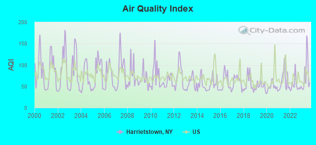
Air Quality Index (AQI) level in 2023 was 77.4. This is about average.
| City: | 77.4 |
| U.S.: | 72.6 |
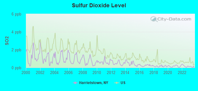
Sulfur Dioxide (SO2) [ppb] level in 2023 was 0.100. This is significantly better than average. Closest monitor was 9.5 miles away from the city center.
| City: | 0.100 |
| U.S.: | 1.515 |
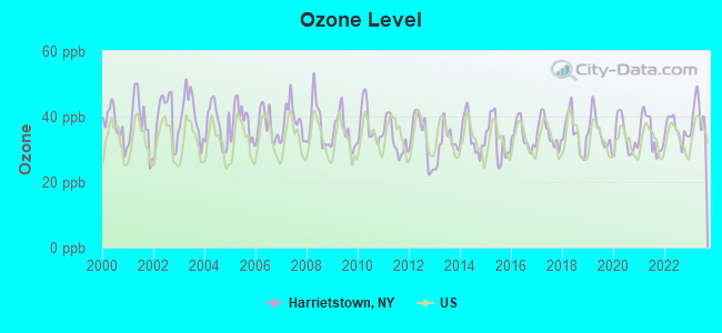
Ozone [ppb] level in 2023 was 40.1. This is worse than average. Closest monitor was 14.8 miles away from the city center.
| City: | 40.1 |
| U.S.: | 33.3 |
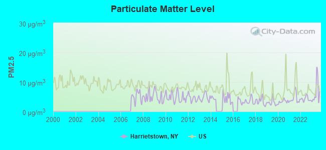
Particulate Matter (PM2.5) [µg/m3] level in 2023 was 6.51. This is better than average. Closest monitor was 17.5 miles away from the city center.
| City: | 6.51 |
| U.S.: | 8.11 |
Earthquake activity:
Harrietstown-area historical earthquake activity is significantly above New York state average. It is 70% smaller than the overall U.S. average.On 10/7/1983 at 10:18:46, a magnitude 5.3 (5.1 MB, 5.3 LG, 5.1 ML, Class: Moderate, Intensity: VI - VII) earthquake occurred 25.4 miles away from the city center
On 4/20/2002 at 10:50:47, a magnitude 5.3 (5.3 ML, Depth: 3.0 mi) earthquake occurred 28.3 miles away from the city center
On 4/20/2002 at 10:50:47, a magnitude 5.2 (5.2 MB, 4.2 MS, 5.2 MW, 5.0 MW) earthquake occurred 26.6 miles away from Harrietstown center
On 1/19/1982 at 00:14:42, a magnitude 4.7 (4.5 MB, 4.7 MD, 4.5 LG, Class: Light, Intensity: IV - V) earthquake occurred 140.5 miles away from the city center
On 10/16/2012 at 23:12:25, a magnitude 4.7 (4.7 ML, Depth: 10.0 mi) earthquake occurred 182.6 miles away from Harrietstown center
On 4/20/2000 at 08:46:55, a magnitude 3.8 (3.8 ML, Depth: 3.1 mi, Class: Light, Intensity: II - III) earthquake occurred 24.7 miles away from the city center
Magnitude types: regional Lg-wave magnitude (LG), body-wave magnitude (MB), duration magnitude (MD), local magnitude (ML), surface-wave magnitude (MS), moment magnitude (MW)
Natural disasters:
The number of natural disasters in Franklin County (15) is near the US average (15).Major Disasters (Presidential) Declared: 9
Emergencies Declared: 5
Causes of natural disasters: Floods: 5, Storms: 5, Hurricanes: 3, Winter Storms: 2, Blizzard: 1, Earthquake: 1, Power Outage: 1, Snowstorm: 1, Tornado: 1, Wind: 1, Other: 2 (Note: some incidents may be assigned to more than one category).

Hospitals and medical centers near Harrietstown:
- ADIRONDACK MEDICAL CENTER UIHLEIN (Nursing Home, about 10 miles away; LAKE PLACID, NY)
- SUNMOUNT SRU 2 (Hospital, about 14 miles away; TUPPER LAKE, NY)
- SUNMOUNT DEVELOPMENTAL CENTER (Hospital, about 14 miles away; TUPPER LAKE, NY)
- ADIRONDACK MEDICAL CENTER MERCY (Nursing Home, about 15 miles away; TUPPER LAKE, NY)
- ADIRONDACK MEDICAL CENTER - DIALYSIS (Dialysis Facility, about 15 miles away; TUPPER LAKE, NY)
Colleges/universities with over 2000 students nearest to Harrietstown:
- SUNY College at Plattsburgh (about 45 miles; Plattsburgh, NY; Full-time enrollment: 5,934)
- SUNY College at Potsdam (about 47 miles; Potsdam, NY; FT enrollment: 4,307)
- Clarkson University (about 48 miles; Potsdam, NY; FT enrollment: 3,472)
- Champlain College (about 51 miles; Burlington, VT; FT enrollment: 2,623)
- University of Vermont (about 51 miles; Burlington, VT; FT enrollment: 11,566)
- Community College of Vermont (about 52 miles; Winooski, VT; FT enrollment: 3,394)
- St Lawrence University (about 52 miles; Canton, NY; FT enrollment: 2,501)
Points of interest:
Notable locations in Harrietstown: Bartletts Carry (A), Saranac Lake Free Library (B), Harrietstown Town Hall (C), Saranac Lake Volunteer Fire Department (D). Display/hide their locations on the map
Churches in Harrietstown include: Saint Johns Church (A), Lake Clear Church (B), Adirondack Alliance Church (C), Kingdom Hall of Jehovahs Witnesses (D), Lutheran Church of the Holy Trinity (E), Saint Bernard's Church (F), Saranac Lake Baptist Church (G), Saranac Lake Seventh Day Adventist Church (H), First United Methodist Church (I). Display/hide their locations on the map
Cemeteries: Saint Bernards Cemetery (1), Saint Johns Cemetery (2), Holy Name Cemetery (3). Display/hide their locations on the map
Lakes: Kiwassa Lake (A), Lily Pad Pond (B), Little Ampersand Pond (C), Little Colby Pond (D), Little Pine Pond (E), Little Weller Pond (F), Lower Saranac Lake (G), McCauley Pond (H). Display/hide their locations on the map
Streams, rivers, and creeks: Beaver Brook (A), Palmer Brook (B), Stony Creek (C), Flag Brook (D), Fish Creek (E), Dutton Brook (F), Fay Brook (G), Roaring Brook (H), Roger Brook (I). Display/hide their locations on the map
| This town: | 2.1 people |
| New York: | 2.6 people |
| This town: | 52.3% |
| Whole state: | 63.5% |
| This town: | 9.8% |
| Whole state: | 6.8% |
Likely homosexual households (counted as self-reported same-sex unmarried-partner households)
- Lesbian couples: 0.3% of all households
- Gay men: 0.2% of all households
| This town: | 12.6% |
| Whole state: | 14.6% |
| This town: | 4.6% |
| Whole state: | 7.4% |
People in group quarters in Harrietstown in 2010:
- 66 people in residential treatment centers for adults
- 64 people in other noninstitutional facilities
- 45 people in group homes intended for adults
People in group quarters in Harrietstown in 2000:
- 52 people in mental (psychiatric) hospitals or wards
- 28 people in homes for the mentally retarded
- 3 people in religious group quarters
- 2 people in hospitals or wards for drug/alcohol abuse
For population 15 years and over in Harrietstown:
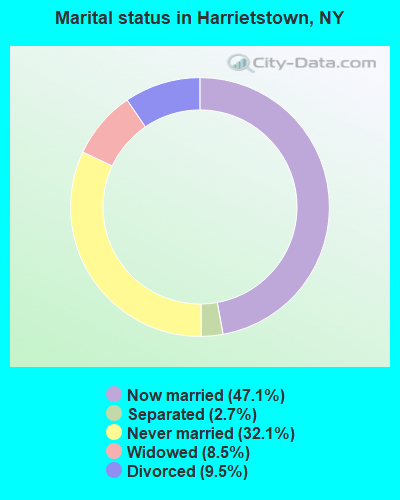
- Never married: 32.1%
- Now married: 47.1%
- Separated: 2.7%
- Widowed: 8.5%
- Divorced: 9.5%
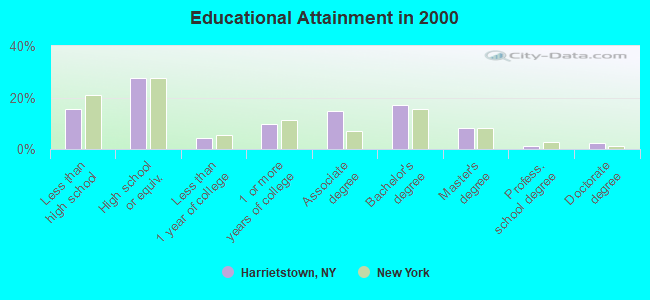
For population 25 years and over in Harrietstown:
- High school or higher: 84.6%
- Bachelor's degree or higher: 28.4%
- Graduate or professional degree: 11.4%
- Unemployed: 3.3%
- Mean travel time to work (commute): 15.1 minutes
| Here: | 12.5 |
| New York average: | 14.2 |
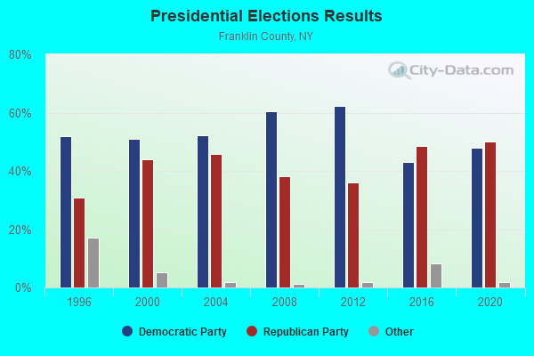
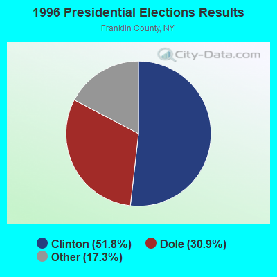
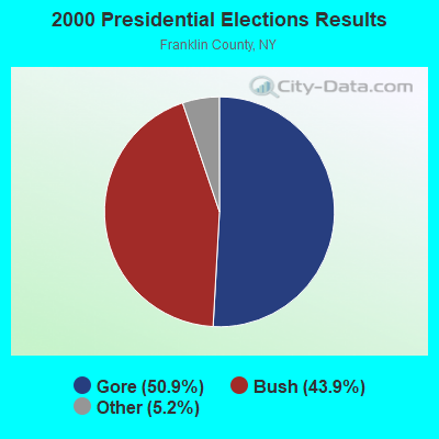
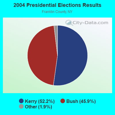
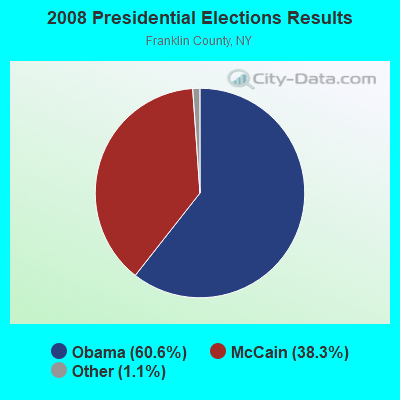
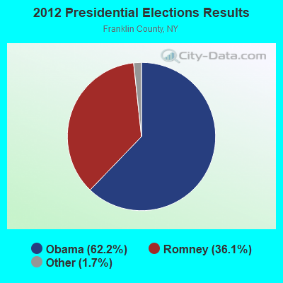
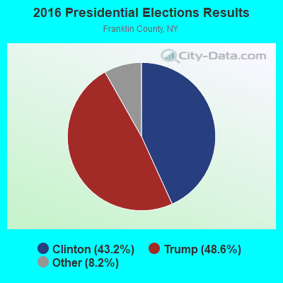

Graphs represent county-level data. Detailed 2008 Election Results
Religion statistics for Harrietstown, NY (based on Franklin County data)
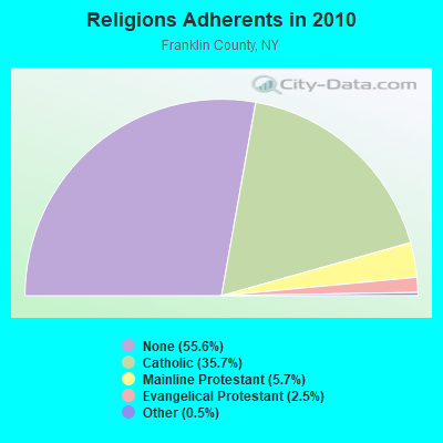
| Religion | Adherents | Congregations |
|---|---|---|
| Catholic | 18,437 | 21 |
| Mainline Protestant | 2,942 | 26 |
| Evangelical Protestant | 1,277 | 19 |
| Other | 253 | 4 |
| None | 28,690 | - |
Food Environment Statistics:
| Franklin County: | 3.57 / 10,000 pop. |
| State: | 4.13 / 10,000 pop. |
| Franklin County: | 1.39 / 10,000 pop. |
| New York: | 0.92 / 10,000 pop. |
| Franklin County: | 4.96 / 10,000 pop. |
| State: | 1.68 / 10,000 pop. |
| Here: | 6.94 / 10,000 pop. |
| New York: | 8.82 / 10,000 pop. |
| Franklin County: | 8.2% |
| New York: | 8.2% |
| Franklin County: | 26.3% |
| New York: | 23.8% |
| Here: | 13.7% |
| State: | 15.6% |
Strongest AM radio stations in Harrietstown:
- WIRD (920 AM; 5 kW; LAKE PLACID, NY; Owner: RADIO LAKE PLACID INC)
- WNBZ (1240 AM; 1 kW; SARANAC LAKE, NY; Owner: SARANAC LAKE RADIO, L.L.C.)
- WICY (1490 AM; 50 kW; MALONE, NY; Owner: CARTIER COMMUNICATIONS INC.)
- WCHP (760 AM; 35 kW; CHAMPLAIN, NY; Owner: CHAMPLAIN RADIO, INC.)
- WGY (810 AM; 50 kW; SCHENECTADY, NY; Owner: CLEAR CHANNEL BROADCASTING LICENSES, INC.)
- WEAV (960 AM; 5 kW; PLATTSBURGH, NY; Owner: CLEAR CHANNEL BROADCASTING LICENSES, INC.)
- WVMT (620 AM; 5 kW; BURLINGTON, VT; Owner: SISON BROADCASTING, INC.)
- WPTR (1540 AM; 50 kW; ALBANY, NY; Owner: KIMTRON, INC.)
- WNNZ (640 AM; 50 kW; WESTFIELD, MA; Owner: CLEAR CHANNEL BROADCASTING LICENSES, INC.)
- WTWK (1070 AM; daytime; 5 kW; PLATTSBURGH, NY; Owner: CHAMPLAIN COMMUNICATIONS CORPORATION)
- WRKO (680 AM; 50 kW; BOSTON, MA; Owner: ENTERCOM BOSTON LICENSE, LLC)
- WCRN (830 AM; 50 kW; WORCESTER, MA; Owner: CARTER BROADCASTING CORPORATION)
- WDEV (550 AM; 5 kW; WATERBURY, VT; Owner: RADIO VERMONT, INC.)
Strongest FM radio stations in Harrietstown:
- WYZY (106.3 FM; SARANAC LAKE, NY; Owner: SARANAC LAKE RADIO, L.L.C.)
- WSLL (90.5 FM; SARANAC LAKE, NY; Owner: THE ST. LAWRENCE UNIVERSITY)
- WRGR (102.3 FM; TUPPER LAKE, NY; Owner: RADIO LAKE PLACID, INC.)
- WYUL (94.7 FM; CHATEAUGAY, NY; Owner: CARTIER COMMUNICATIONS INC.)
- WXLH (91.3 FM; BLUE MOUNTAIN LAKE, NY; Owner: THE ST. LAWRENCE UNIVERSITY)
- WCEL (91.9 FM; PLATTSBURGH, NY; Owner: WAMC)
- WXLG (89.9 FM; NORTH CREEK, NY; Owner: THE ST. LAWRENCE UNIVERSITY)
- WXLU (88.3 FM; PERU, NY; Owner: THE ST. LAWRENCE UNIVERSITY)
- WCVT (101.7 FM; STOWE, VT; Owner: RADIO VERMONT CLASSICS, L.L.C.)
- WEZF (92.9 FM; BURLINGTON, VT; Owner: CAPSTAR TX LIMITED PARTNERSHIP)
- WVPS (107.9 FM; BURLINGTON, VT; Owner: VERMONT PUBLIC RADIO)
- WDEV-FM (96.1 FM; WARREN, VT; Owner: RADIO VERMONT, INC.)
- WLKC (103.3 FM; WATERBURY, VT; Owner: RADIO BROADCASTING SERVICES, INC.)
- WBTZ (99.9 FM; PLATTSBURGH, NY; Owner: PLATTSBURGH BROADCASTING CORPORATION)
TV broadcast stations around Harrietstown:
- WPTZ (Channel 5; NORTH POLE, NY; Owner: HEARST-ARGYLE STATIONS, INC.)
- WNPI-TV (Channel 18; NORWOOD, NY; Owner: ST. LAWRENCE VALLEY EDUCATIONAL TV COUNCIL, INC)
- National Bridge Inventory (NBI) Statistics
- 5Number of bridges
- 36ft / 11.2mTotal length
- $3,908,000Total costs
- 5,797Total average daily traffic
- 435Total average daily truck traffic
- 6,086Total future (year 2034) average daily traffic
FCC Registered Antenna Towers: 23 (See the full list of FCC Registered Antenna Towers)
- 82.2%Fuel oil, kerosene, etc.
- 8.7%Wood
- 5.5%Bottled, tank, or LP gas
- 3.6%Electricity
- 68.7%Fuel oil, kerosene, etc.
- 21.2%Electricity
- 3.8%Bottled, tank, or LP gas
- 2.7%Wood
- 2.6%Utility gas
- 0.6%Other fuel
- 0.5%No fuel used
Harrietstown compared to New York state average:
- Median house value below state average.
- Unemployed percentage significantly below state average.
- Black race population percentage significantly below state average.
- Hispanic race population percentage significantly below state average.
- Foreign-born population percentage significantly below state average.
- Length of stay since moving in significantly above state average.
- Number of rooms per house significantly below state average.
- House age significantly below state average.
Harrietstown on our top lists:
- #2 on the list of "Top 101 cities with largest percentage of females in industries: religious, grantmaking, civic, professional, and similar organizations (population 5,000+)"
- #5 on the list of "Top 101 cities with largest percentage of males in occupations: other health diagnosing and treating practitioners and technical occupations (population 5,000+)"
- #11 on the list of "Top 101 cities with largest percentage of females in occupations: counselors, social workers, and other community and social service specialists (population 5,000+)"
- #12 on the list of "Top 101 cities with largest percentage of males in occupations: child care workers (population 5,000+)"
- #13 on the list of "Top 101 cities with largest percentage of males in industries: religious, grantmaking, civic, professional, and similar organizations (population 5,000+)"
- #14 on the list of "Top 101 cities with largest percentage of females in occupations: carpenters (population 5,000+)"
- #23 on the list of "Top 101 cities with largest percentage of males in industries: water transportation (population 5,000+)"
- #24 on the list of "Top 101 cities with largest percentage of males in occupations: cooks and food preparation workers (population 5,000+)"
- #25 on the list of "Top 101 cities with largest percentage of males in occupations: printing workers (population 5,000+)"
- #29 on the list of "Top 101 cities with largest percentage of males in industries: health care (population 5,000+)"
- #34 on the list of "Top 101 cities with the most people taking a taxi to work (population 5,000+)"
- #50 on the list of "Top 101 cities with largest percentage of females in industries: clothing and accessories, including shoe, stores (population 5,000+)"
- #51 on the list of "Top 101 cities with largest percentage of males in industries: fuel dealers (population 5,000+)"
- #51 on the list of "Top 101 cities with largest percentage of males in industries: social assistance (population 5,000+)"
- #56 on the list of "Top 101 cities with largest percentage of females in industries: leather and allied products (population 5,000+)"
- #58 on the list of "Top 101 cities with largest percentage of females in industries: building material and garden equipment and supplies dealers (population 5,000+)"
- #72 on the list of "Top 101 cities with the largest percentage of people in mental (psychiatric) hospitals or wards (population 1,000+)"
- #72 on the list of "Top 101 cities with largest percentage of males in industries: jewelry, luggage, and leather goods stores (population 5,000+)"
- #73 on the list of "Top 101 cities with largest percentage of males in industries: pharmacies and drug stores (population 5,000+)"
- #84 on the list of "Top 101 cities with largest percentage of females in industries: pharmacies and drug stores (population 5,000+)"
- #1 on the list of "Top 101 counties with the lowest Ozone (1-hour) air pollution readings in 2012 (ppm)"
- #52 on the list of "Top 101 counties with the smallest number of children under 18 without health insurance coverage in 2000 (pop. 50,000+)"
- #66 on the list of "Top 101 counties with the smallest number of people without health insurance coverage in 2000 (pop. 50,000+)"
- #68 on the list of "Top 101 counties with the lowest percentage of residents relocating from other counties between 2010 and 2011 (pop. 50,000+)"
- #91 on the list of "Top 101 counties with the lowest percentage of residents relocating to other counties in 2011 (pop. 50,000+)"