Henrietta, Wisconsin
Submit your own pictures of this town and show them to the world
- OSM Map
- Google Map
- MSN Map
Population change since 2000: +2.9%
 |
| Males: 256 | |
| Females: 237 |
| Median resident age: | 50.2 years |
| Wisconsin median age: | 42.6 years |
Zip codes: 54634.
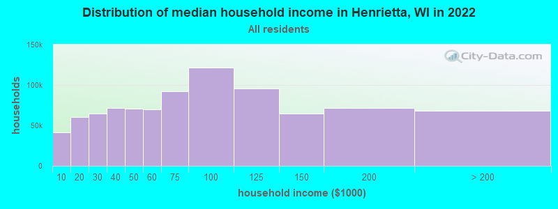
| Henrietta: | $56,011 |
| WI: | $70,996 |
Estimated per capita income in 2022: $34,521 (it was $17,598 in 2000)
Henrietta town income, earnings, and wages data
Estimated median house or condo value in 2022: $208,149 (it was $95,500 in 2000)
| Henrietta: | $208,149 |
| WI: | $252,800 |
Mean prices in 2022: all housing units: $250,850; detached houses: $261,473; townhouses or other attached units: $613,931; in 2-unit structures: $276,599; in 5-or-more-unit structures: $248,379; mobile homes: $59,249; occupied boats, rvs, vans, etc.: $29,774
Detailed information about poverty and poor residents in Henrietta, WI
Compare current foreclosures near Henrietta, WI:
| Photo | Address | Area | Beds / Baths | Price | Details |
|---|---|---|---|---|---|
|
|
#1
Eagle Ct
La Valle, WI 53941
|
- sq. feet
|
2 baths 3 beds |
show details | |

|
#2
State Road 82
Elroy, WI 53929
|
- sq. feet
|
- baths - beds |
show details | |

|
#3
Veterans Dr Lot 35
Richland Center, WI 53581
|
- sq. feet
|
- baths - beds |
show details | |

|
#4
Franklin St
Elroy, WI 53929
|
- sq. feet
|
- baths - beds |
show details | |

|
#5
S Wagoner Ave
Viola, WI 54664
|
- sq. feet
|
- baths - beds |
show details | |

|
#6
State Hwy 171
Muscoda, WI 53573
|
- sq. feet
|
- baths - beds |
show details | |

|
#7
Gudenschwager Rd
La Valle, WI 53941
|
- sq. feet
|
- baths - beds |
show details | |

|
#8
Division St
Union Center, WI 53962
|
- sq. feet
|
- baths - beds |
show details | |

|
#9
W Seminary St
Richland Center, WI 53581
|
- sq. feet
|
- baths - beds |
show details | |

|
#10
County Hwy E # A
Richland Center, WI 53581
|
- sq. feet
|
- baths - beds |
show details |
| Photo | Address | Area | Beds / Baths | Price | Details |
|---|---|---|---|---|---|

|
#11
E Maple St
La Valle, WI 53941
|
- sq. feet
|
- baths - beds |
show details | |

|
#12
County Rd S
La Valle, WI 53941
|
- sq. feet
|
- baths - beds |
show details | |

|
#13
E Gage St
Richland Center, WI 53581
|
- sq. feet
|
- baths - beds |
show details | |

|
#14
County Hwy A
Richland Center, WI 53581
|
- sq. feet
|
- baths - beds |
show details | |

|
#15
E South St
Richland Center, WI 53581
|
- sq. feet
|
- baths - beds |
show details | |

|
#16
Jackson St
Richland Center, WI 53581
|
- sq. feet
|
- baths - beds |
show details | |

|
#17
N Main St
Viola, WI 54664
|
- sq. feet
|
- baths - beds |
show details | |

|
#18
N Church St
Richland Center, WI 53581
|
- sq. feet
|
- baths - beds |
show details | |

|
#19
Clary Ln
Richland Center, WI 53581
|
- sq. feet
|
- baths - beds |
show details | |

|
#20
W Elroy St
Elroy, WI 53929
|
- sq. feet
|
- baths - beds |
show details |
| Photo | Address | Area | Beds / Baths | Price | Details |
|---|---|---|---|---|---|

|
#21
South St
Cazenovia, WI 53924
|
- sq. feet
|
- baths - beds |
show details | |

|
Check over 1 million property listings on Foreclosure.com!
|
browse all offers | |||

- 48097.4%White alone
- 40.8%American Indian alone
- 30.6%Black alone
- 20.4%Asian alone
- 20.4%Other race alone
- 20.4%Hispanic
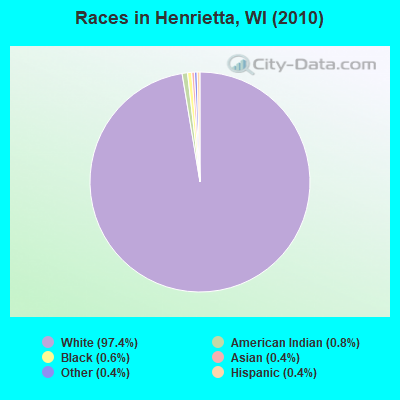
Races in Henrietta detailed stats: ancestries, foreign born residents, place of birth
 Recent articles from our blog. Our writers, many of them Ph.D. graduates or candidates, create easy-to-read articles on a wide variety of topics.
Ancestries: German (25.9%), Irish (14.4%), English (13.8%), Czech (10.6%), Norwegian (9.4%), United States (9.0%).
Current Local Time: CST time zone
Land area: 35.9 square miles.
Population density: 14 people per square mile (very low).
| Henrietta town: | 0.7% ($710) |
| Wisconsin: | 2.0% ($2,245) |
Nearest city with pop. 50,000+: La Crosse, WI  (47.7 miles , pop. 51,818).
Nearest city with pop. 200,000+: Madison, WI (57.8 miles , pop. 208,054).
Nearest city with pop. 1,000,000+: Chicago, IL (179.2 miles , pop. 2,896,016).
Nearest cities:
), ), ), ), ), ), )Latitude: 43.51 N, Longitude: 90.38 W
Area code commonly used in this area: 608
| Here: | 2.6% |
| Wisconsin: | 2.7% |
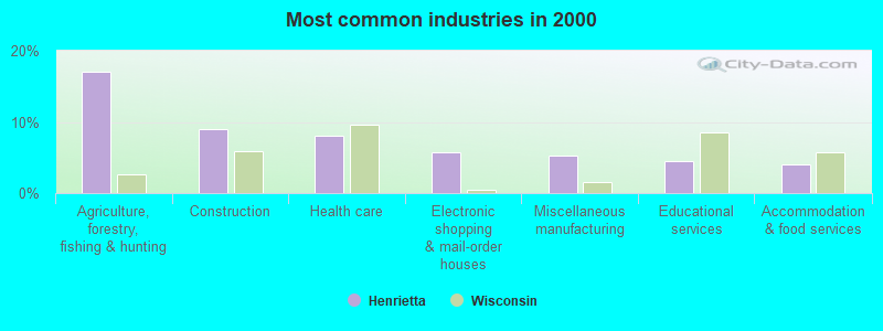
- Agriculture, forestry, fishing & hunting (17.1%)
- Construction (8.9%)
- Health care (8.1%)
- Electronic shopping & mail-order houses (5.7%)
- Miscellaneous manufacturing (5.3%)
- Educational services (4.5%)
- Accommodation & food services (4.1%)
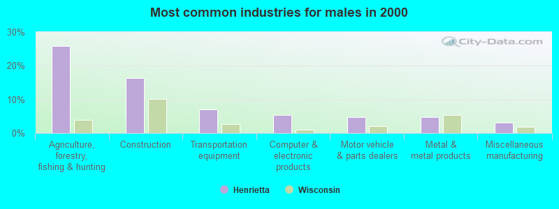
- Agriculture, forestry, fishing & hunting (25.8%)
- Construction (16.4%)
- Transportation equipment (7.0%)
- Computer & electronic products (5.5%)
- Motor vehicle & parts dealers (4.7%)
- Metal & metal products (4.7%)
- Miscellaneous manufacturing (3.1%)
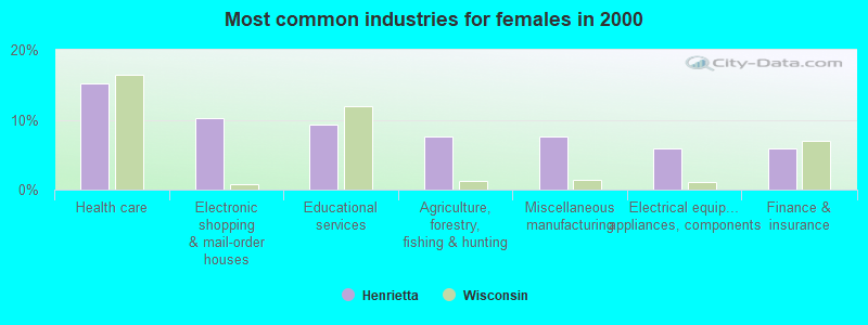
- Health care (15.3%)
- Electronic shopping & mail-order houses (10.2%)
- Educational services (9.3%)
- Agriculture, forestry, fishing & hunting (7.6%)
- Miscellaneous manufacturing (7.6%)
- Electrical equipment, appliances, components (5.9%)
- Finance & insurance (5.9%)
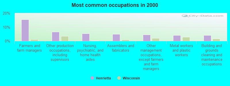
- Farmers and farm managers (15.4%)
- Other production occupations, including supervisors (6.5%)
- Nursing, psychiatric, and home health aides (5.3%)
- Assemblers and fabricators (4.9%)
- Other management occupations, except farmers and farm managers (4.5%)
- Metal workers and plastic workers (4.1%)
- Building and grounds cleaning and maintenance occupations (4.1%)
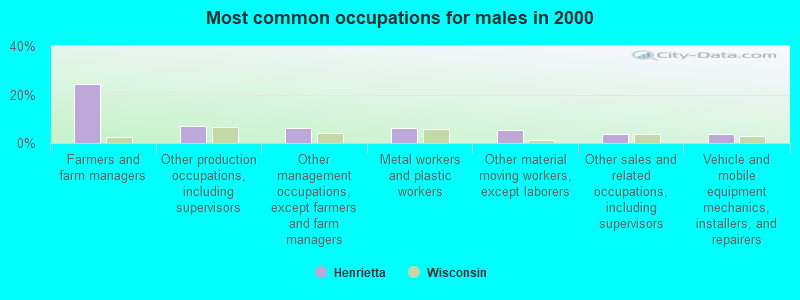
- Farmers and farm managers (24.2%)
- Other production occupations, including supervisors (7.0%)
- Other management occupations, except farmers and farm managers (6.2%)
- Metal workers and plastic workers (6.2%)
- Other material moving workers, except laborers (5.5%)
- Other sales and related occupations, including supervisors (3.9%)
- Vehicle and mobile equipment mechanics, installers, and repairers (3.9%)
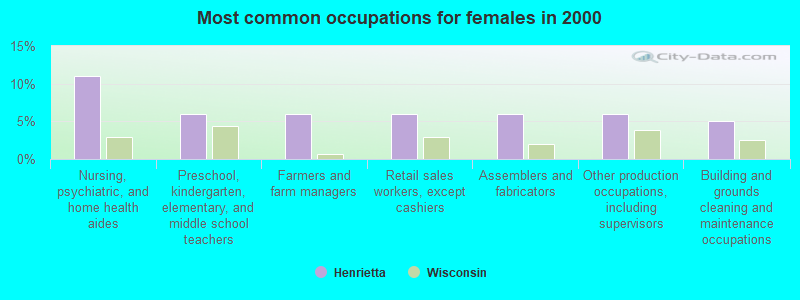
- Nursing, psychiatric, and home health aides (11.0%)
- Preschool, kindergarten, elementary, and middle school teachers (5.9%)
- Farmers and farm managers (5.9%)
- Retail sales workers, except cashiers (5.9%)
- Assemblers and fabricators (5.9%)
- Other production occupations, including supervisors (5.9%)
- Building and grounds cleaning and maintenance occupations (5.1%)
Average climate in Henrietta, Wisconsin
Based on data reported by over 4,000 weather stations


Tornado activity:
Henrietta-area historical tornado activity is slightly above Wisconsin state average. It is 42% greater than the overall U.S. average.
On 4/11/1965, a category F4 (max. wind speeds 207-260 mph) tornado 24.0 miles away from the Henrietta town center killed one person and injured 3 people and caused between $500,000 and $5,000,000 in damages.
On 6/7/1984, a category F5 (max. wind speeds 261-318 mph) tornado 42.3 miles away from the town center killed 9 people and injured 200 people and caused between $50,000 and $500,000 in damages.
Earthquake activity:
Henrietta-area historical earthquake activity is significantly above Wisconsin state average. It is 43% greater than the overall U.S. average.On 4/18/2008 at 09:36:59, a magnitude 5.4 (5.1 MB, 4.8 MS, 5.4 MW, 5.2 MW, Class: Moderate, Intensity: VI - VII) earthquake occurred 373.2 miles away from Henrietta center
On 6/28/2004 at 06:10:52, a magnitude 4.2 (4.2 MW, Depth: 6.2 mi, Class: Light, Intensity: IV - V) earthquake occurred 160.5 miles away from the city center
On 6/10/1987 at 23:48:54, a magnitude 5.1 (4.9 MB, 4.4 MS, 4.6 MS, 5.1 LG) earthquake occurred 349.2 miles away from Henrietta center
On 4/18/2008 at 09:36:59, a magnitude 5.2 (5.2 MW, Depth: 8.9 mi) earthquake occurred 373.2 miles away from Henrietta center
On 2/10/2010 at 09:59:35, a magnitude 3.8 (3.8 MW, Depth: 6.2 mi, Class: Light, Intensity: II - III) earthquake occurred 143.0 miles away from Henrietta center
On 7/9/1975 at 14:54:15, a magnitude 4.6 (4.6 MB) earthquake occurred 316.4 miles away from the city center
Magnitude types: regional Lg-wave magnitude (LG), body-wave magnitude (MB), surface-wave magnitude (MS), moment magnitude (MW)
Natural disasters:
The number of natural disasters in Richland County (18) is near the US average (15).Major Disasters (Presidential) Declared: 14
Emergencies Declared: 2
Causes of natural disasters: Floods: 15, Storms: 15, Tornadoes: 8, Winds: 4, Landslides: 2, Mudslides: 2, Drought: 1, Heavy Rain: 1, Hurricane: 1, Other: 1 (Note: some incidents may be assigned to more than one category).
Hospitals and medical centers near Henrietta:
- ST JOSEPHS HLTH SVCS Critical Access Hospitals (about 10 miles away; HILLSBORO, WI)
- ST JOSEPHS MEMORIAL HOSPITAL (Hospital, about 10 miles away; HILLSBORO, WI)
- SCHMITT WOODLAND HILLS (Nursing Home, about 13 miles away; RICHLAND CENTER, WI)
- PINE VALLEY HLTH CARE REHAB (Nursing Home, about 15 miles away; RICHLAND CENTER, WI)
Colleges/universities with over 2000 students nearest to Henrietta:
- University of Wisconsin-La Crosse (about 48 miles; La Crosse, WI; Full-time enrollment: 9,837)
- Viterbo University (about 48 miles; La Crosse, WI; FT enrollment: 2,848)
- Western Technical College (about 49 miles; La Crosse, WI; FT enrollment: 3,377)
- University of Wisconsin-Platteville (about 54 miles; Platteville, WI; FT enrollment: 7,679)
- Edgewood College (about 58 miles; Madison, WI; FT enrollment: 2,455)
- University of Wisconsin-Madison (about 58 miles; Madison, WI; FT enrollment: 34,621)
- University of Wisconsin Colleges (about 58 miles; Madison, WI; FT enrollment: 10,019)
Points of interest:
Notable locations in Henrietta: Beranek Stock and Grain Farm (A), Bridgeway Farm (B), Castle Rock Stock Farm (C), Hart Homestead (D), Edgewood Farm (E), Evergreen Lawn Farm (F), Glen Echo Fruit and Dairy Farm (G), Highview Farm (H), Indian Creek Farm (I), Meehoec Stock and Grain Farm (J), Oakview Farm (K), Pine River Valley Farm (L), Pine River View Farm (M), Pleasant Valley Farm (N), Pleasant Valley Stock Farm (O), Spring Grove Guernsey Farm (P), Sunnyside Farm (Q), Cottage Grove Farm (R), Echo Glen Stock Farm (S), Evergreen Hollow Farm (T). Display/hide their locations on the map
Church in Henrietta: Saint Patricks Church (A). Display/hide its location on the map
Cemeteries: Saint Patrick Lutheran Cemetery (1), Soules Creek Cemetery (2). Display/hide their locations on the map
Streams, rivers, and creeks: Indian Creek (A), Lebansky Creek (B), Hanzel Creek (C), Grinsell Branch (D), Johnston Creek (E), Soules Creek (F), Melancthon Creek (G). Display/hide their locations on the map
Park in Henrietta: Hub City Bog State Natural Area (1). Display/hide its location on the map
| This town: | 2.4 people |
| Wisconsin: | 2.4 people |
| This town: | 72.9% |
| Whole state: | 64.4% |
| This town: | 6.4% |
| Whole state: | 7.3% |
Likely homosexual households (counted as self-reported same-sex unmarried-partner households)
- Lesbian couples: 0.5% of all households
- Gay men: 0.5% of all households
| This town: | 8.9% |
| Whole state: | 8.7% |
| This town: | 4.7% |
| Whole state: | 3.7% |
For population 15 years and over in Henrietta:
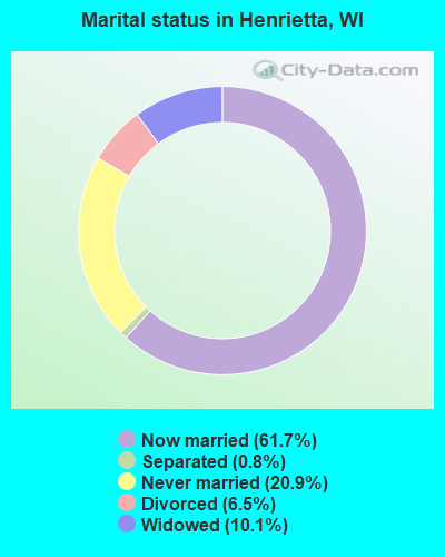
- Never married: 20.9%
- Now married: 61.7%
- Separated: 0.8%
- Widowed: 10.1%
- Divorced: 6.5%
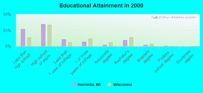
For population 25 years and over in Henrietta:
- High school or higher: 72.3%
- Bachelor's degree or higher: 15.1%
- Graduate or professional degree: 4.7%
- Unemployed: 1.2%
- Mean travel time to work (commute): 32.4 minutes
| Here: | 11.9 |
| Wisconsin average: | 11.0 |
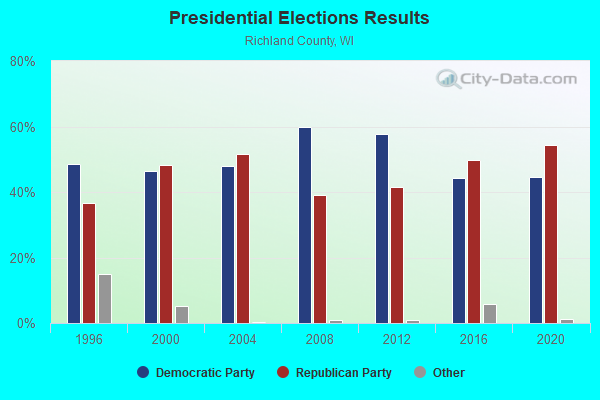
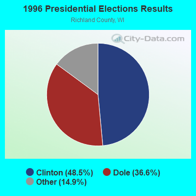
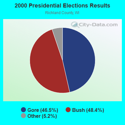
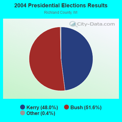

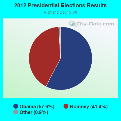
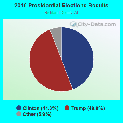
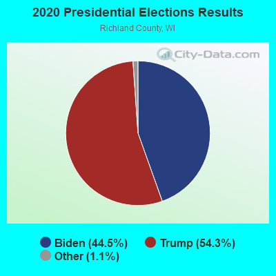
Graphs represent county-level data. Detailed 2008 Election Results
Religion statistics for Henrietta, WI (based on Richland County data)
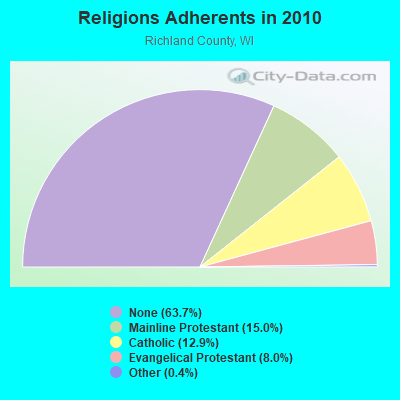
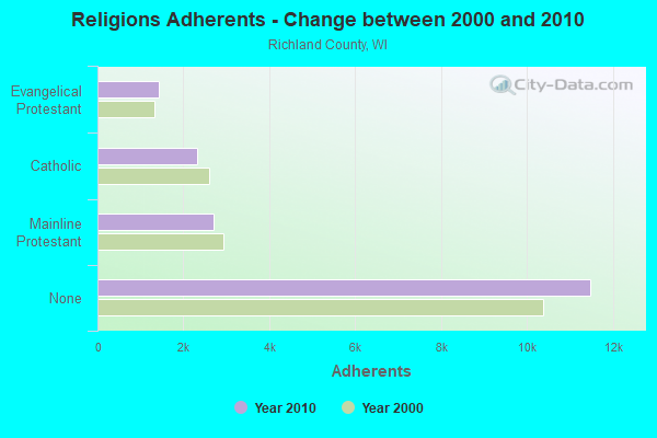
| Religion | Adherents | Congregations |
|---|---|---|
| Mainline Protestant | 2,706 | 14 |
| Catholic | 2,330 | 4 |
| Evangelical Protestant | 1,435 | 16 |
| Other | 65 | 2 |
| None | 11,485 | - |
Food Environment Statistics:
| Richland County: | 2.20 / 10,000 pop. |
| Wisconsin: | 1.86 / 10,000 pop. |
| Here: | 0.55 / 10,000 pop. |
| Wisconsin: | 0.11 / 10,000 pop. |
| Richland County: | 0.55 / 10,000 pop. |
| State: | 0.38 / 10,000 pop. |
| Richland County: | 5.51 / 10,000 pop. |
| State: | 4.12 / 10,000 pop. |
| This county: | 9.36 / 10,000 pop. |
| Wisconsin: | 8.64 / 10,000 pop. |
| Richland County: | 7.7% |
| State: | 7.6% |
| Richland County: | 29.2% |
| Wisconsin: | 27.5% |
| This county: | 17.4% |
| Wisconsin: | 13.0% |
Strongest AM radio stations in Henrietta:
- WSPT (1010 AM; 50 kW; STEVENS POINT, WI)
- WTMJ (620 AM; 50 kW; MILWAUKEE, WI; Owner: JOURNAL BROADCAST CORPORATION)
- WKTY (580 AM; 5 kW; LA CROSSE, WI; Owner: FAMILY RADIO, INC.)
- WRCO (1450 AM; 1 kW; RICHLAND CENTER, WI; Owner: FRUIT BROADCASTING, LLC)
- WNAM (1280 AM; 50 kW; NEENAH-MENASHA, WI; Owner: CUMULUS LICENSING CORP.)
- WSAU (550 AM; 20 kW; WAUSAU, WI; Owner: WRIG, INC.)
- WSCR (670 AM; 50 kW; CHICAGO, IL; Owner: INFINITY BROADCASTING OPERATIONS, INC.)
- WISN (1130 AM; 50 kW; MILWAUKEE, WI; Owner: CAPSTAR TX LIMITED PARTNERSHIP)
- WGN (720 AM; 50 kW; CHICAGO, IL; Owner: WGN CONTINENTAL BROADCASTING CO.)
- WKLJ (1290 AM; 5 kW; SPARTA, WI; Owner: SPARTA-TOMAH BROADCASTING CO., INC.)
- WBBM (780 AM; 50 kW; CHICAGO, IL; Owner: INFINITY BROADCASTING OPERATIONS, INC.)
- WRDB (1400 AM; 1 kW; REEDSBURG, WI; Owner: NEWRADIO GROUP, LLC)
- WTSO (1070 AM; 10 kW; MADISON, WI; Owner: CAPSTAR TX LIMITED PARTNERSHIP)
Strongest FM radio stations in Henrietta:
- WVCX (98.9 FM; TOMAH, WI; Owner: VCY AMERICA, INC.)
- WOLX-FM (94.9 FM; BARABOO, WI; Owner: ENTERCOM MADISON LICENSE, LLC.)
- WRJC-FM (92.1 FM; MAUSTON, WI; Owner: WRJC, INCORPORATED)
- WRCO-FM (100.9 FM; RICHLAND CENTER, WI; Owner: FRUIT BROADCASTING, LLC)
- WNFM (104.9 FM; REEDSBURG, WI; Owner: NEWRADIO GROUP, LLC)
- WBDL (102.9 FM; REEDSBURG, WI; Owner: NEWRADIO GROUP, LLC)
- WXYM (96.1 FM; TOMAH, WI; Owner: MAGNUM RADIO, INC.)
- WBOG (94.5 FM; TOMAH, WI; Owner: MAGNUM RADIO, INC.)
- WHHI (91.3 FM; HIGHLAND, WI; Owner: STATE OF WISCONSIN - EDUCATIONAL COMMUNICATIONS BOARD)
TV broadcast stations around Henrietta:
- WDLS-LP (Channel 35; TOMAH, WI; Owner: MAGNUM RADIO, INC.)
- WISC-TV (Channel 3; MADISON, WI; Owner: TELEVISION WISCONSIN, INC.)
- WMSN-TV (Channel 47; MADISON, WI; Owner: WMSN LICENSEE, LLC)
- National Bridge Inventory (NBI) Statistics
- 30Number of bridges
- 161ft / 48.7mTotal length
- $215,000Total costs
- 18,057Total average daily traffic
- 1,920Total average daily truck traffic
- 20,882Total future (year 2037) average daily traffic
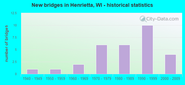
- New bridges - historical statistics
- 11940-1949
- 11950-1959
- 21960-1969
- 61970-1979
- 61980-1989
- 101990-1999
- 42000-2009

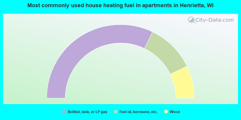
- 63.7%Bottled, tank, or LP gas
- 25.4%Wood
- 9.3%Fuel oil, kerosene, etc.
- 1.6%Electricity
- 64.3%Bottled, tank, or LP gas
- 21.4%Fuel oil, kerosene, etc.
- 14.3%Wood
Henrietta compared to Wisconsin state average:
- Unemployed percentage significantly below state average.
- Black race population percentage significantly below state average.
- Hispanic race population percentage significantly below state average.
- Median age above state average.
- Foreign-born population percentage significantly below state average.
- Renting percentage significantly below state average.
- Length of stay since moving in significantly above state average.
- Number of rooms per house significantly below state average.
- House age significantly below state average.
- Number of college students significantly below state average.
- Percentage of population with a bachelor's degree or higher below state average.