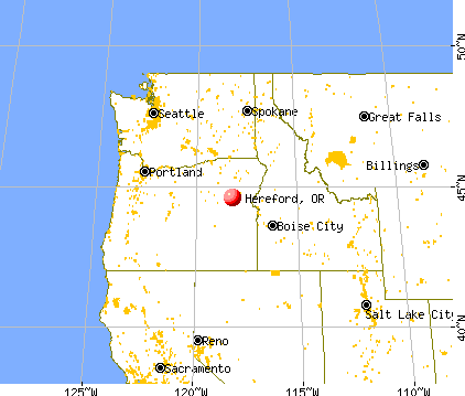
Hereford, Oregon
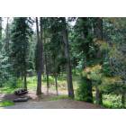
Hereford: Campsite in the Blue Mtns....
Hereford: They Arrived by Wagon Train....
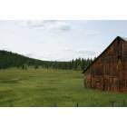
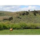
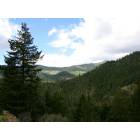
Hereford: Pretty Country...
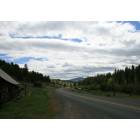
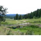
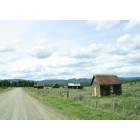
Hereford: Along Hwy 7 .....
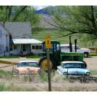
Hereford: That's a 41 chevy in the middle....
Hereford: You Talkin To Meee??...
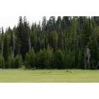
Hereford: Elk in the Blue Mtns....
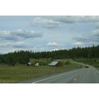
Hereford: Along Hwy 7 near Whitney.....
Hereford: Blue Mtns....
Hereford: Old Mercs.....
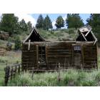
Hereford: Diehards still live in the Ghost Town of Whitney....
- see
15
more - add
your
Submit your own pictures of this place and show them to the world
- OSM Map
- General Map
- Google Map
- MSN Map

| Males: 501 | |
| Females: 460 |
| Median resident age: | 47.1 years |
| Oregon median age: | 36.3 years |
Zip code: 97814
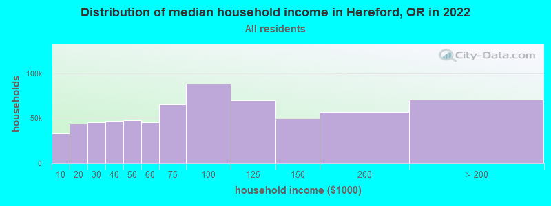
| Hereford: | $52,993 |
| OR: | $75,657 |
Estimated per capita income in 2022: $34,773 (it was $16,354 in 2000)
Hereford CCD income, earnings, and wages data
Estimated median house or condo value in 2022: $382,935 (it was $130,900 in 2000)
| Hereford: | $382,935 |
| OR: | $475,600 |
Mean prices in 2022: all housing units: $339,228; detached houses: $346,395; townhouses or other attached units: $334,037; in 5-or-more-unit structures: $236,336; mobile homes: $301,620; occupied boats, rvs, vans, etc.: $55,971
Detailed information about poverty and poor residents in Hereford, OR


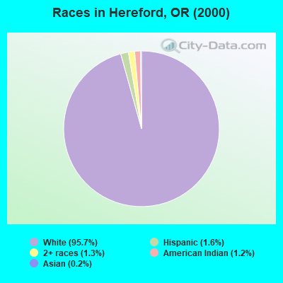
- 96195.7%White alone
- 161.6%Hispanic
- 131.3%Two or more races
- 121.2%American Indian alone
- 20.2%Asian alone
Races in Hereford detailed stats: ancestries, foreign born residents, place of birth
 Recent articles from our blog. Our writers, many of them Ph.D. graduates or candidates, create easy-to-read articles on a wide variety of topics.
Current Local Time: PST time zone
Elevation: 3700 feet
Land area: 852.3 square miles.
Population density: 1.1 people per square mile (very low).
| Hereford CCD: | 0.7% ($856) |
| Oregon: | 1.2% ($1,687) |
Nearest city with pop. 50,000+: Nampa, ID  (108.0 miles , pop. 51,867).
Nearest city with pop. 200,000+: Northwest Clackamas, OR (222.5 miles , pop. 224,220).
Nearest city with pop. 1,000,000+: Los Angeles, CA (726.7 miles , pop. 3,694,820).
Nearest cities:
), Latitude: 44.59 N, Longitude: 118.21 W
Area code commonly used in this area: 541

| Here: | 4.7% |
| Oregon: | 3.9% |
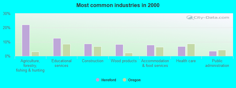
- Agriculture, forestry, fishing & hunting (22.2%)
- Educational services (12.6%)
- Construction (8.6%)
- Wood products (8.4%)
- Accommodation & food services (7.9%)
- Health care (6.9%)
- Public administration (3.6%)
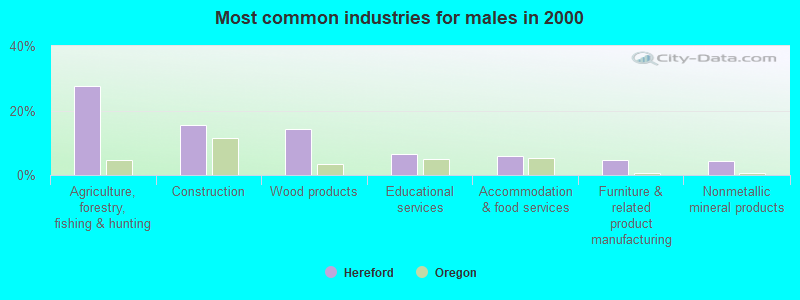
- Agriculture, forestry, fishing & hunting (27.5%)
- Construction (15.5%)
- Wood products (14.2%)
- Educational services (6.4%)
- Accommodation & food services (6.0%)
- Furniture & related product manufacturing (4.7%)
- Nonmetallic mineral products (4.3%)
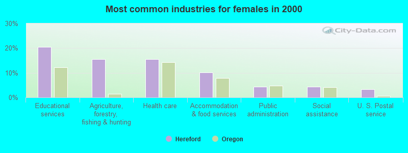
- Educational services (20.4%)
- Agriculture, forestry, fishing & hunting (15.6%)
- Health care (15.6%)
- Accommodation & food services (10.2%)
- Public administration (4.3%)
- Social assistance (4.3%)
- U. S. Postal service (3.2%)
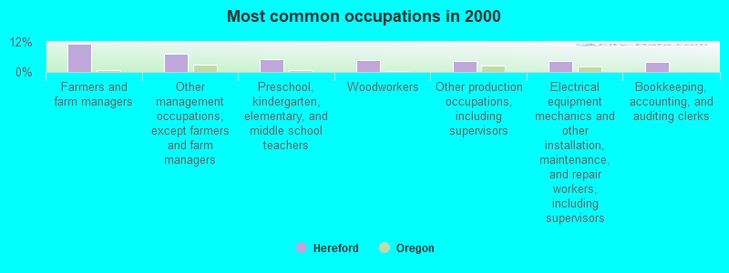
- Farmers and farm managers (11.2%)
- Other management occupations, except farmers and farm managers (7.4%)
- Preschool, kindergarten, elementary, and middle school teachers (5.0%)
- Woodworkers (4.8%)
- Other production occupations, including supervisors (4.3%)
- Electrical equipment mechanics and other installation, maintenance, and repair workers, including supervisors (4.3%)
- Bookkeeping, accounting, and auditing clerks (4.1%)
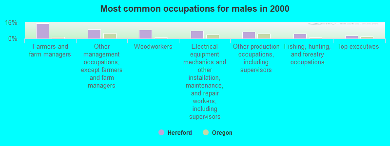
- Farmers and farm managers (15.0%)
- Other management occupations, except farmers and farm managers (9.4%)
- Woodworkers (8.6%)
- Electrical equipment mechanics and other installation, maintenance, and repair workers, including supervisors (7.7%)
- Other production occupations, including supervisors (6.9%)
- Fishing, hunting, and forestry occupations (4.7%)
- Top executives (3.0%)
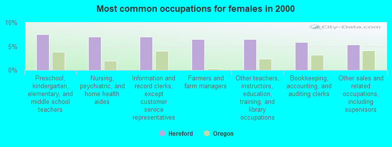
- Preschool, kindergarten, elementary, and middle school teachers (7.5%)
- Nursing, psychiatric, and home health aides (7.0%)
- Information and record clerks, except customer service representatives (7.0%)
- Farmers and farm managers (6.5%)
- Other teachers, instructors, education, training, and library occupations (6.5%)
- Bookkeeping, accounting, and auditing clerks (5.9%)
- Other sales and related occupations, including supervisors (5.4%)
Average climate in Hereford, Oregon
Based on data reported by over 4,000 weather stations


(lower is better)
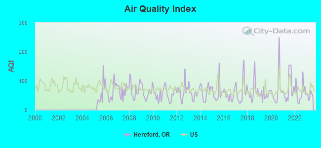
Air Quality Index (AQI) level in 2023 was 50.8. This is significantly better than average.
| City: | 50.8 |
| U.S.: | 72.6 |
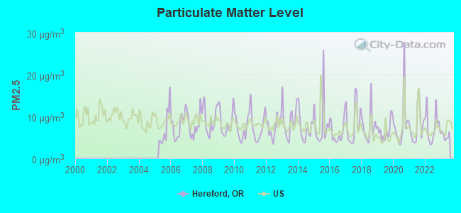
Particulate Matter (PM2.5) [µg/m3] level in 2023 was 5.38. This is significantly better than average. There were 0 monitors within city limits.
| City: | 5.38 |
| U.S.: | 8.11 |
Earthquake activity:
Hereford-area historical earthquake activity is significantly above Oregon state average. It is 2109% greater than the overall U.S. average.On 10/3/1915 at 06:52:48, a magnitude 7.6 (7.6 UK, Class: Major, Intensity: VIII - XII) earthquake occurred 285.3 miles away from the city center
On 10/28/1983 at 14:06:06, a magnitude 7.3 (6.2 MB, 7.3 MS, 7.0 MW) earthquake occurred 221.2 miles away from the city center, causing 2 deaths (2 shaking deaths) and 3 injuries, causing $15,000,000 total damage
On 8/18/1959 at 06:37:13, a magnitude 7.7 (7.7 UK) earthquake occurred 372.3 miles away from the city center, causing $26,000,000 total damage
On 3/31/2020 at 23:52:30, a magnitude 6.5 (6.5 MW, Depth: 7.5 mi, Class: Strong, Intensity: VII - IX) earthquake occurred 153.0 miles away from Hereford center
On 4/13/1949 at 19:55:42, a magnitude 7.0 (7.0 UK) earthquake occurred 276.2 miles away from Hereford center, causing $80,000,000 total damage
On 2/28/2001 at 18:54:32, a magnitude 6.8 (6.5 MB, 6.6 MS, 6.8 MW) earthquake occurred 272.2 miles away from the city center, causing $2,000,000,000 total damage and $305,000,000 insured losses
Magnitude types: body-wave magnitude (MB), surface-wave magnitude (MS), moment magnitude (MW)
Natural disasters:
The number of natural disasters in Baker County (7) is smaller than the US average (15).Major Disasters (Presidential) Declared: 4
Emergencies Declared: 2
Causes of natural disasters: Floods: 2, Winter Storms: 2, Drought: 1, Fire: 1, Heavy Rain: 1, Hurricane: 1, Other: 1 (Note: some incidents may be assigned to more than one category).
Colleges/universities with over 2000 students nearest to Hereford:
- Eastern Oregon University (about 51 miles; La Grande, OR; Full-time enrollment: 3,127)
- Treasure Valley Community College (about 74 miles; Ontario, OR; FT enrollment: 2,055)
- Walla Walla Community College (about 104 miles; Walla Walla, WA; FT enrollment: 4,263)
- College of Western Idaho (about 109 miles; Nampa, ID; FT enrollment: 6,300)
- Northwest Nazarene University (about 109 miles; Nampa, ID; FT enrollment: 2,290)
- Boise State University (about 121 miles; Boise, ID; FT enrollment: 16,774)
- Columbia Basin College (about 123 miles; Pasco, WA; FT enrollment: 5,111)
Points of interest:
Notable locations in Hereford: Yellow Pine Recreation Site (A), McCully Recreation Site (B), Ironside C and H Corrals (C), South Fork Camp Creek Campground (D), King Ranch (E), Hale Ranch (F), Hudspeth Cow Camp (G), Hudspeth Corral (H), Stevens Creek Recreation Site (I), HB Murray (J), Murray Reservoir Recreation Site (K), Geiser (L), Fopian Campground (M), Elk Creek Recreation Site (N), Mammoth Spring Recreation Site (O), Long Creek Recreation Site (P), Deer Creek Recreation Site (Q), Cracker Camp (R), Mason Dam Recreation Site (S), Powell Ranch (T). Display/hide their locations on the map
Cemeteries: Whitney Cemetery (1), Greenhorn Cemetery (2), McEwen Cemetery (3), Boyer Family Cemetery (4), Auburn Cemetery (5), Blue Mountain Cemetery (6), Bridgeport Cemetery (7). Display/hide their locations on the map
Lakes, reservoirs, and swamps: Mud Spring Pond (A), Iris Pond (B), Tammy Pond (C), Swale Pond (D), Rock Pond (E), Railroad Pond (F), Midway Pond (G), Sunflower Flat Pond (H). Display/hide their locations on the map
Streams, rivers, and creeks: Winterville Creek (A), Worley Creek (B), Outhouse Creek (C), King Creek (D), Job Creek (E), Jackknife Creek (F), Horseshoe Creek (G), Harris Creek (H), Greenhorn Creek (I). Display/hide their locations on the map
Parks in Hereford include: Unity Forest State Park (1), Unity Lake State Recreation Site (2). Display/hide their locations on the map
| This place: | 2.0 people |
| Oregon: | 2.5 people |
| This place: | 60.8% |
| Whole state: | 63.4% |
| This place: | 6.3% |
| Whole state: | 8.0% |
No gay or lesbian households reported
| This place: | 10.0% |
| Whole state: | 11.6% |
| This place: | 6.1% |
| Whole state: | 5.0% |
For population 15 years and over in Hereford:
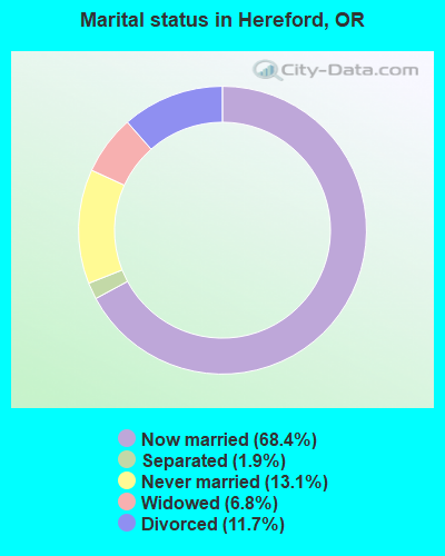
- Never married: 13.1%
- Now married: 68.4%
- Separated: 1.9%
- Widowed: 6.8%
- Divorced: 11.7%
For population 25 years and over in Hereford:
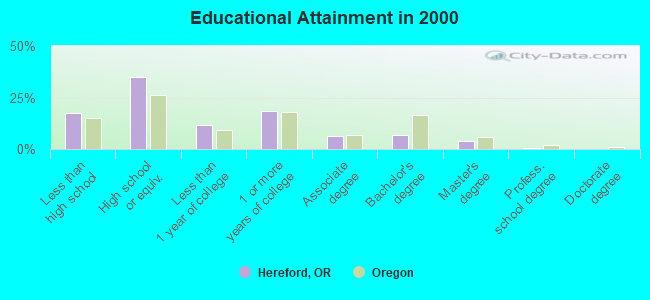
- High school or higher: 82.7%
- Bachelor's degree or higher: 11.5%
- Graduate or professional degree: 4.4%
- Unemployed: 9.9%
- Mean travel time to work (commute): 19.9 minutes
| Here: | 8.7 |
| Oregon average: | 11.5 |
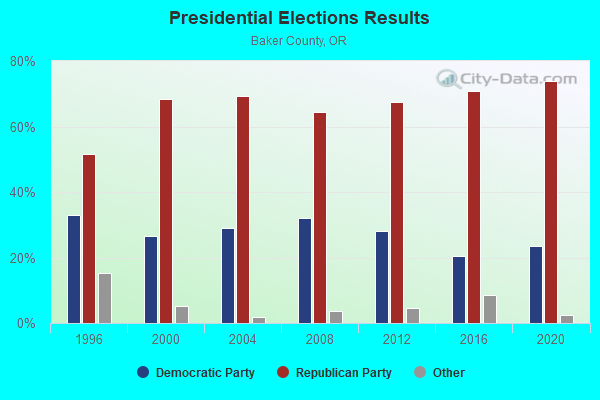
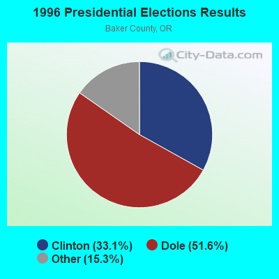
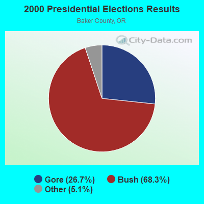
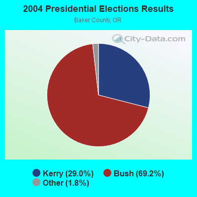
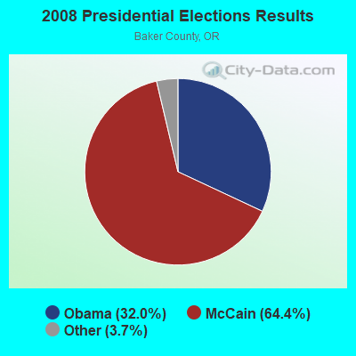
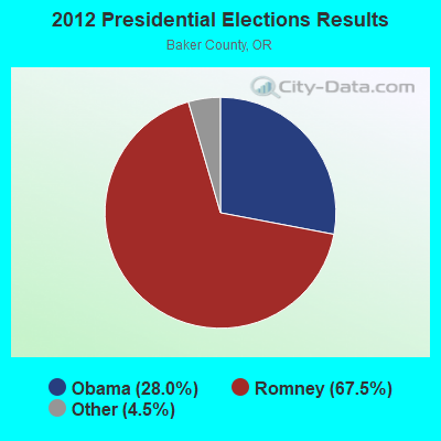
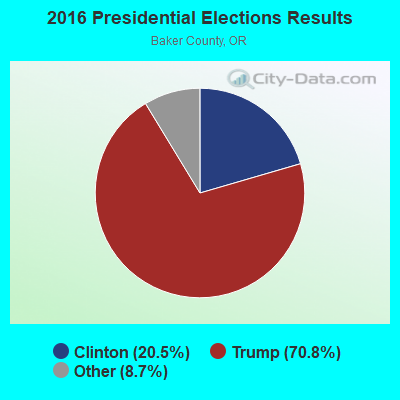
Graphs represent county-level data. Detailed 2008 Election Results
Religion statistics for Hereford, OR (based on Baker County data)
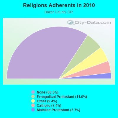
| Religion | Adherents | Congregations |
|---|---|---|
| Evangelical Protestant | 1,778 | 21 |
| Other | 1,515 | 8 |
| Catholic | 1,196 | 3 |
| Mainline Protestant | 595 | 6 |
| None | 11,050 | - |
Food Environment Statistics:
| This county: | 5.66 / 10,000 pop. |
| Oregon: | 2.03 / 10,000 pop. |
| This county: | 0.63 / 10,000 pop. |
| State: | 0.33 / 10,000 pop. |
| Here: | 1.26 / 10,000 pop. |
| Oregon: | 2.01 / 10,000 pop. |
| This county: | 4.40 / 10,000 pop. |
| State: | 1.69 / 10,000 pop. |
| This county: | 13.20 / 10,000 pop. |
| Oregon: | 9.93 / 10,000 pop. |
| Baker County: | 9.8% |
| State: | 7.4% |
| Baker County: | 25.3% |
| Oregon: | 25.6% |
| Baker County: | 13.0% |
| Oregon: | 14.2% |
Strongest AM radio stations in Hereford:
- KWEI (1260 AM; 50 kW; WEISER, ID; Owner: TREASURE VALLEY BROADCASTING CO.)
- KBOI (670 AM; 50 kW; BOISE, ID; Owner: CITADEL BROADCASTING COMPANY)
- KPOJ (620 AM; 50 kW; PORTLAND, OR; Owner: CITICASTERS LICENSES, L.P.)
- KTBI (810 AM; daytime; 50 kW; EPHRATA, WA; Owner: TACOMA BROADCASTERS, INCORPORATED)
- KXL (750 AM; 50 kW; PORTLAND, OR; Owner: ROSE CITY RADIO CORPORATION)
- KBSU (730 AM; 15 kW; BOISE, ID; Owner: IDAHO STATE BOARD OF EDUCATION)
- KBKR (1490 AM; 1 kW; BAKER, OR; Owner: GRANDE RADIO, INC.)
- KPAM (860 AM; 50 kW; TROUTDALE, OR; Owner: PAMPLIN BROADCASTING-OREGON, INC.)
- KOTK (1080 AM; 50 kW; PORTLAND, OR; Owner: FISHER BROADCASTING - PORTLAND RADIO, L.L.C.)
- KQQQ (1150 AM; 25 kW; PULLMAN, WA; Owner: RADIO PALOUSE, INC.)
- KBGN (1060 AM; daytime; 10 kW; CALDWELL, ID; Owner: NELSON M. AND KAREN E. WILSON)
- KEX (1190 AM; 50 kW; PORTLAND, OR; Owner: CITICASTERS LICENSES, L.P.)
- KIRO (710 AM; 50 kW; SEATTLE, WA; Owner: ENTERCOM SEATTLE LICENSE, LLC)
Strongest FM radio stations in Hereford:
- K214CF (90.7 FM; BAKER, OR; Owner: AMERICAN FAMILY ASSOCIATION)
- KCMB (104.7 FM; BAKER, OR; Owner: OREGON TRAIL RADIO, INC.)
- KUBQ (98.7 FM; LA GRANDE, OR; Owner: GRANDE RADIO, INC.)
- KJDY-FM (94.5 FM; CANYON CITY, OR; Owner: BLUE MOUNTAIN BROADCASTING CO., INC.)
Hereford fatal accident list:
FCC Registered Broadcast Land Mobile Towers:
3- Lat: 44.500528 Lon: -118.041472, Call Sign: WQKC860,
Assigned Frequencies: 451.187 MHz, 456.187 MHz, 451.312 MHz, 456.312 MHz, 451.412 MHz, Grant Date: 04/02/2009, Expiration Date: 04/02/2019, Cancellation Date: 06/08/2019, Certifier: Nathan Moore, Registrant: Gem State Communications, Inc., 1976 Century Way, Boise, ID 83709, Phone: (208) 323-1976, Fax: (208) 323-1122, Email:
- Lat: 44.505278 Lon: -118.138556, Call Sign: WQWH526,
Assigned Frequencies: 451.350 MHz, 463.625 MHz, 463.400 MHz, Grant Date: 08/24/2015, Expiration Date: 08/24/2025, Certifier: Pat Schiewe, Registrant: Gem State Communications, Inc., 1976 S Century Way, Boise, ID 83709, Phone: (208) 323-1976, Fax: (208) 323-1122, Email:
- Lat: 44.500528 Lon: -118.041472, Call Sign: WRDX247,
Assigned Frequencies: 456.312 MHz, 451.187 MHz, 451.312 MHz, 451.412 MHz, 456.187 MHz, Grant Date: 08/10/2019, Expiration Date: 08/10/2029, Certifier: Nathan Moore, Registrant: Radio Licensing Services, Milwaukie, OR 97269, Phone: (503) 659-1240, Fax: (503) 794-3759, Email:
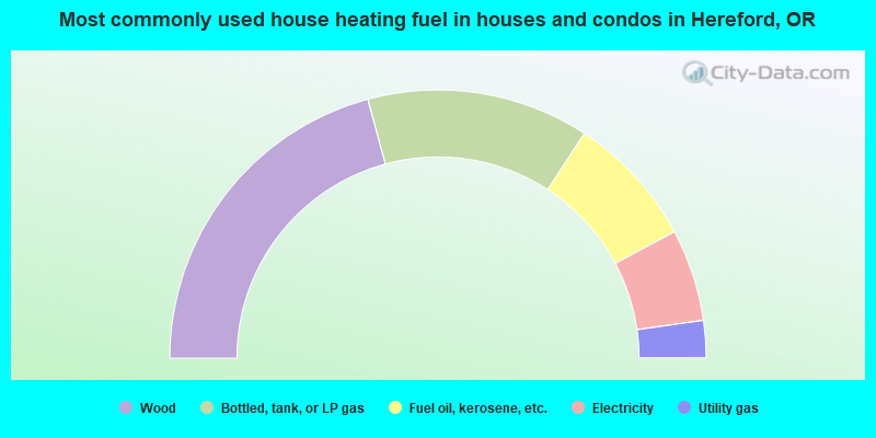
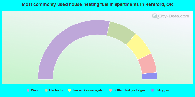
- 41.6%Wood
- 26.8%Bottled, tank, or LP gas
- 16.0%Fuel oil, kerosene, etc.
- 11.1%Electricity
- 4.5%Utility gas
- 56.7%Wood
- 15.4%Electricity
- 13.5%Fuel oil, kerosene, etc.
- 10.6%Bottled, tank, or LP gas
- 3.8%Utility gas
Hereford compared to Oregon state average:
- Black race population percentage significantly below state average.
- Hispanic race population percentage significantly below state average.
- Median age significantly above state average.
- Foreign-born population percentage significantly below state average.
- Renting percentage below state average.
- Length of stay since moving in significantly above state average.
- Number of rooms per house significantly below state average.
- House age significantly below state average.
- Number of college students below state average.
- Percentage of population with a bachelor's degree or higher significantly below state average.