Hill, New Hampshire
Submit your own pictures of this town and show them to the world
Detailed information about poverty and poor residents in Hill, NH
 Recent articles from our blog. Our writers, many of them Ph.D. graduates or candidates, create easy-to-read articles on a wide variety of topics.
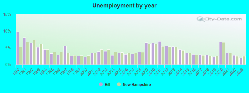
| Here: | 1.9% |
| New Hampshire: | 2.5% |
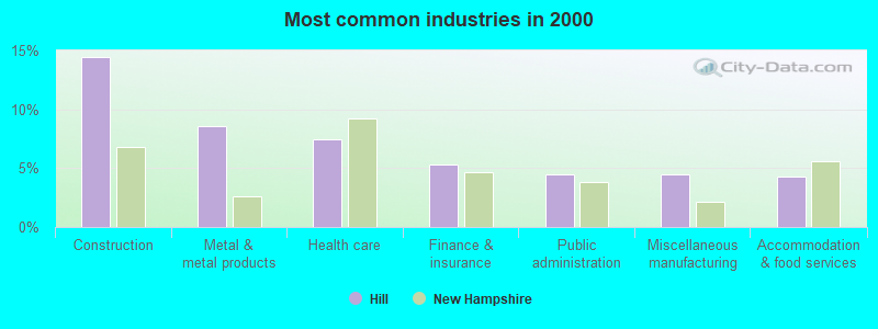
- Construction (14.4%)
- Metal & metal products (8.5%)
- Health care (7.5%)
- Finance & insurance (5.3%)
- Public administration (4.4%)
- Miscellaneous manufacturing (4.4%)
- Accommodation & food services (4.3%)
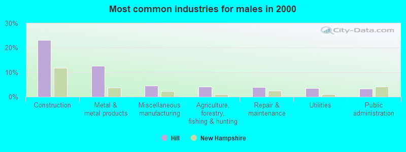
- Construction (23.2%)
- Metal & metal products (12.5%)
- Miscellaneous manufacturing (4.5%)
- Agriculture, forestry, fishing & hunting (4.2%)
- Repair & maintenance (3.9%)
- Utilities (3.5%)
- Public administration (3.2%)
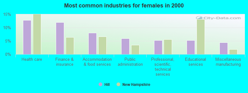
- Health care (12.7%)
- Finance & insurance (12.0%)
- Accommodation & food services (8.0%)
- Public administration (6.0%)
- Professional, scientific, technical services (5.2%)
- Educational services (5.2%)
- Miscellaneous manufacturing (4.4%)

- Metal workers and plastic workers (5.9%)
- Material recording, scheduling, dispatching, and distributing workers (5.3%)
- Electrical equipment mechanics and other installation, maintenance, and repair workers, including supervisors (4.3%)
- Other production occupations, including supervisors (4.1%)
- Retail sales workers, except cashiers (4.1%)
- Construction traders workers except carpenters, electricians, painters, plumbers, and construction laborers (4.1%)
- Other office and administrative support workers, including supervisors (3.6%)
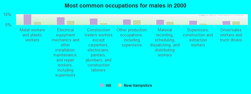
- Metal workers and plastic workers (10.0%)
- Electrical equipment mechanics and other installation, maintenance, and repair workers, including supervisors (7.7%)
- Construction traders workers except carpenters, electricians, painters, plumbers, and construction laborers (6.4%)
- Other production occupations, including supervisors (5.5%)
- Material recording, scheduling, dispatching, and distributing workers (5.1%)
- Supervisors, construction and extraction workers (4.2%)
- Driver/sales workers and truck drivers (3.9%)
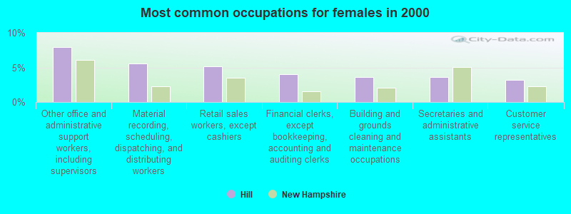
- Other office and administrative support workers, including supervisors (8.0%)
- Material recording, scheduling, dispatching, and distributing workers (5.6%)
- Retail sales workers, except cashiers (5.2%)
- Financial clerks, except bookkeeping, accounting and auditing clerks (4.0%)
- Building and grounds cleaning and maintenance occupations (3.6%)
- Secretaries and administrative assistants (3.6%)
- Customer service representatives (3.2%)
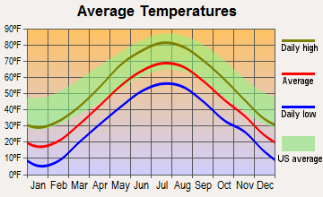
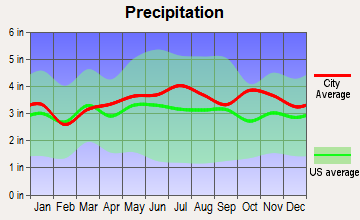
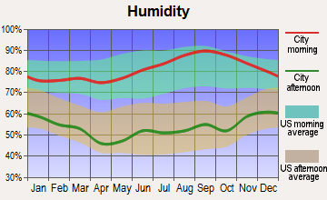
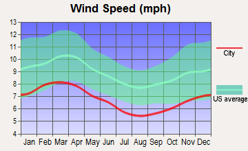
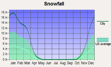
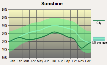
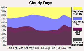
Average climate in Hill, New Hampshire
Based on data reported by over 4,000 weather stations
(lower is better)

Air Quality Index (AQI) level in 2022 was 51.1. This is significantly better than average.
| City: | 51.1 |
| U.S.: | 72.6 |
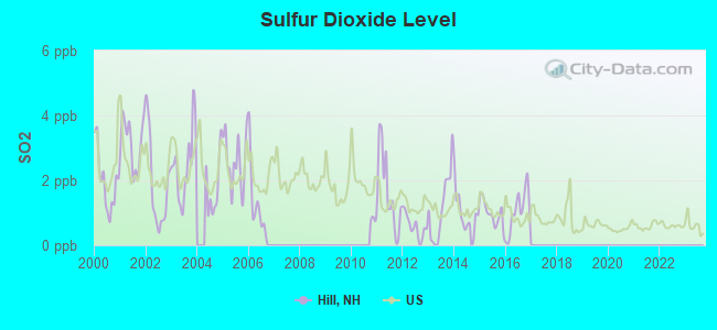
Sulfur Dioxide (SO2) [ppb] level in 2016 was 1.05. This is significantly better than average. Closest monitor was 16.0 miles away from the city center.
| City: | 1.05 |
| U.S.: | 1.51 |
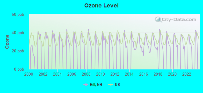
Ozone [ppb] level in 2022 was 29.6. This is about average. Closest monitor was 12.5 miles away from the city center.
| City: | 29.6 |
| U.S.: | 33.3 |
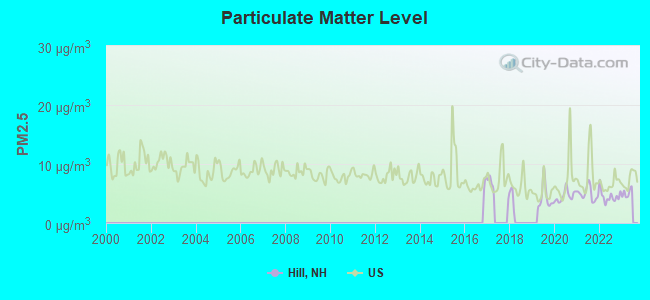
Particulate Matter (PM2.5) [µg/m3] level in 2022 was 4.52. This is significantly better than average. Closest monitor was 12.5 miles away from the city center.
| City: | 4.52 |
| U.S.: | 8.11 |
Tornado activity:
Hill-area historical tornado activity is near New Hampshire state average. It is 58% smaller than the overall U.S. average.
On 5/11/1973, a category F2 (max. wind speeds 113-157 mph) tornado 11.1 miles away from the Hill town center .
On 7/3/1972, a category F2 tornado 17.0 miles away from the town center injured 7 people and caused between $5000 and $50,000 in damages.
Earthquake activity:
Hill-area historical earthquake activity is significantly above New Hampshire state average. It is 71% smaller than the overall U.S. average.On 4/20/2002 at 10:50:47, a magnitude 5.3 (5.3 ML, Depth: 3.0 mi, Class: Moderate, Intensity: VI - VII) earthquake occurred 119.1 miles away from Hill center
On 10/7/1983 at 10:18:46, a magnitude 5.3 (5.1 MB, 5.3 LG, 5.1 ML) earthquake occurred 133.5 miles away from the city center
On 1/19/1982 at 00:14:42, a magnitude 4.7 (4.5 MB, 4.7 MD, 4.5 LG, Class: Light, Intensity: IV - V) earthquake occurred 7.1 miles away from Hill center
On 4/20/2002 at 10:50:47, a magnitude 5.2 (5.2 MB, 4.2 MS, 5.2 MW, 5.0 MW) earthquake occurred 119.0 miles away from Hill center
On 10/16/2012 at 23:12:25, a magnitude 4.7 (4.7 ML, Depth: 10.0 mi) earthquake occurred 54.5 miles away from the city center
On 8/21/1996 at 07:54:14, a magnitude 3.8 (3.8 LG, 3.6 LG, Depth: 6.2 mi, Class: Light, Intensity: II - III) earthquake occurred 49.7 miles away from the city center
Magnitude types: regional Lg-wave magnitude (LG), body-wave magnitude (MB), duration magnitude (MD), local magnitude (ML), surface-wave magnitude (MS), moment magnitude (MW)
Natural disasters:
The number of natural disasters in Merrimack County (27) is a lot greater than the US average (15).Major Disasters (Presidential) Declared: 17
Emergencies Declared: 9
Causes of natural disasters: Storms: 13, Floods: 12, Winter Storms: 4, Snowstorms: 3, Hurricanes: 2, Snows: 2, Blizzard: 1, Ice Storm: 1, Snowfall: 1, Tornado: 1, Tropical Storm: 1, Wind: 1, Other: 1 (Note: some incidents may be assigned to more than one category).

Hospitals and medical centers near Hill:
- NEWFOUND AREA NURSING ASSN (Home Health Center, about 6 miles away; BRISTOL, NH)
- MERRILL MANOR NURSING HOME (Nursing Home, about 7 miles away; FRANKLIN, NH)
- FRANKLIN REGIONAL HOSPITAL Critical Access Hospitals (about 8 miles away; FRANKLIN, NH)
- MERRILL MANOR ANNEX (Nursing Home, about 8 miles away; FRANKLIN, NH)
- VNA OF FRANKLIN (Home Health Center, about 8 miles away; FRANKLIN, NH)
- MOUNTAIN RIDGE CENTER, GENESIS HEALTHCARE (Nursing Home, about 8 miles away; FRANKLIN, NH)
- MERRIMACK COUNTY NURSING HOME (Nursing Home, about 13 miles away; BOSCAWEN, NH)
Colleges/universities with over 2000 students nearest to Hill:
- Plymouth State University (about 17 miles; Plymouth, NH; Full-time enrollment: 4,838)
- NHTI-Concord's Community College (about 24 miles; Concord, NH; FT enrollment: 2,865)
- Dartmouth College (about 31 miles; Hanover, NH; FT enrollment: 6,030)
- Southern New Hampshire University (about 37 miles; Manchester, NH; FT enrollment: 16,552)
- Saint Anselm College (about 39 miles; Manchester, NH; FT enrollment: 2,059)
- Mount Washington College (about 41 miles; Manchester, NH; FT enrollment: 2,187)
- University of New Hampshire-Main Campus (about 49 miles; Durham, NH; FT enrollment: 15,243)
Public elementary/middle school in Hill:
- JENNIE D. BLAKE SCHOOL (Students: 90, Location: 32 CRESCENT ST, Grades: KG-6)
Points of interest:
Notable location: Hill Fire Department (A). Display/hide its location on the map
Churches in Hill include: Hill Center Church (A), Hill Village Bible Church (B). Display/hide their locations on the map
Cemeteries: Hill Center Church Yard (1), Pleasant Hill Cemetery (2), Bunker Hill Cemetery (3). Display/hide their locations on the map
Lakes and swamps: March Pond (A), Poverty Pond (B), Foster Swamp (C). Display/hide their locations on the map
Streams, rivers, and creeks: Pine Hill Brook (A), Needle Shop Brook (B), Dyer Brook (C), Dickinson Brook (D). Display/hide their locations on the map
Park in Hill: Murray Hill Summer Home District (1). Display/hide its location on the map
Drinking water stations with addresses in Hill and their reported violations in the past:
HILL WATER WORKS (Population served: 350, Groundwater):Past monitoring violations:
- Water Quality Parameter M/R - In JAN-01-2006, Contaminant: Lead and Copper Rule. Follow-up actions: St Formal NOV issued (SEP-29-2006), St Violation/Reminder Notice (SEP-29-2006), St Public Notif requested (SEP-29-2006), St Public Notif received (NOV-03-2006), State No Longer Subject to Rule (JUL-18-2007)
| This town: | 2.6 people |
| New Hampshire: | 2.5 people |
| This town: | 73.1% |
| Whole state: | 66.3% |
| This town: | 11.1% |
| Whole state: | 8.3% |
Likely homosexual households (counted as self-reported same-sex unmarried-partner households)
- Lesbian couples: 0.7% of all households
- Gay men: 0.5% of all households
| This town: | 4.2% |
| Whole state: | 6.5% |
| This town: | 3.6% |
| Whole state: | 2.8% |
| Here: | 8.6 |
| New Hampshire average: | 10.9 |
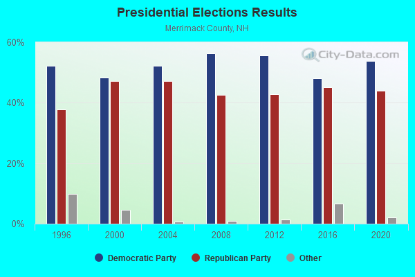
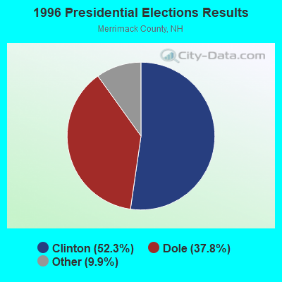
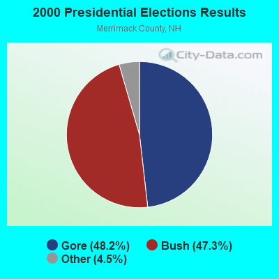
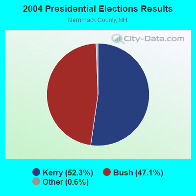

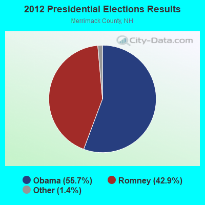
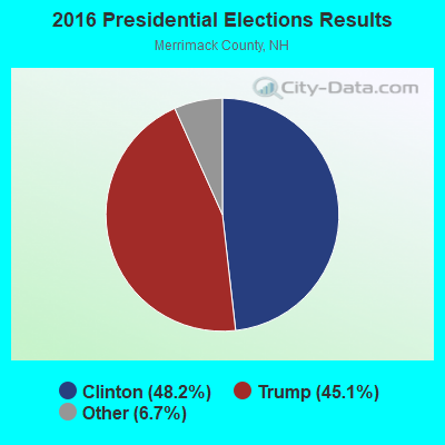
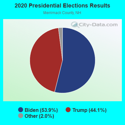
Graphs represent county-level data. Detailed 2008 Election Results
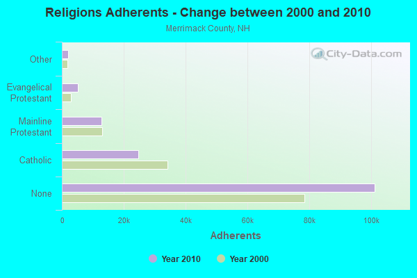
Religion statistics for Hill, NH (based on Merrimack County data)
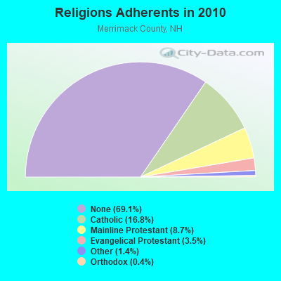
| Religion | Adherents | Congregations |
|---|---|---|
| Catholic | 24,654 | 7 |
| Mainline Protestant | 12,791 | 51 |
| Evangelical Protestant | 5,195 | 36 |
| Other | 2,097 | 15 |
| Orthodox | 580 | 2 |
| None | 101,128 | - |
Food Environment Statistics:
| Merrimack County: | 1.82 / 10,000 pop. |
| State: | 2.14 / 10,000 pop. |
| This county: | 0.14 / 10,000 pop. |
| State: | 0.15 / 10,000 pop. |
| This county: | 1.22 / 10,000 pop. |
| New Hampshire: | 1.78 / 10,000 pop. |
| This county: | 4.39 / 10,000 pop. |
| New Hampshire: | 4.02 / 10,000 pop. |
| Merrimack County: | 7.77 / 10,000 pop. |
| State: | 9.70 / 10,000 pop. |
| This county: | 7.4% |
| New Hampshire: | 7.6% |
| This county: | 23.8% |
| New Hampshire: | 24.4% |
| This county: | 16.9% |
| New Hampshire: | 15.9% |
Strongest AM radio stations in Hill:
- WEZS (1350 AM; 5 kW; LACONIA, NH; Owner: GARY W. HAMMOND)
- WFTN (1240 AM; 1 kW; FRANKLIN, NH; Owner: NORTHEAST COMMUNICATIONS CORPORATION)
- WNTK (1020 AM; 10 kW; NEWPORT, NH; Owner: KOOR COMMUNICATIONS, INC.)
- WPNH (1300 AM; 5 kW; PLYMOUTH, NH; Owner: NORTHEAST COMMUNICATIONS CORPORATION)
- WRKO (680 AM; 50 kW; BOSTON, MA; Owner: ENTERCOM BOSTON LICENSE, LLC)
- WCRN (830 AM; 50 kW; WORCESTER, MA; Owner: CARTER BROADCASTING CORPORATION)
- WEEI (850 AM; 50 kW; BOSTON, MA; Owner: ENTERCOM BOSTON LICENSE, LLC)
- WNNZ (640 AM; 50 kW; WESTFIELD, MA; Owner: CLEAR CHANNEL BROADCASTING LICENSES, INC.)
- WGIN (930 AM; 10 kW; ROCHESTER, NH; Owner: CAPSTAR TX LIMITED PARTNERSHIP)
- WKOX (1200 AM; 50 kW; FRAMINGHAM, MA; Owner: CAPSTAR TX LIMITED PARTNERSHIP)
- WGIR (610 AM; 5 kW; MANCHESTER, NH; Owner: CAPSTAR TX LIMITED PARTNERSHIP)
- WBZ (1030 AM; 50 kW; BOSTON, MA; Owner: INFINITY BROADCASTING OPERATIONS, INC.)
- WASR (1420 AM; 5 kW; WOLFEBORO, NH; Owner: RADIO WOLFEBORO, INC.)
Strongest FM radio stations in Hill:
- WNHI (93.3 FM; BELMONT, NH; Owner: CONCORD BROADCASTING, L.L.C.)
- WPNH-FM (100.1 FM; PLYMOUTH, NH; Owner: NORTHEAST COMMUNICATIONS CORPORATION)
- WFTN-FM (94.1 FM; FRANKLIN, NH; Owner: NORTHEAST COMMUNICATIONS CORPORATION)
- WSCY (106.9 FM; MOULTONBOROUGH, NH; Owner: NORTHEAST COMMUNICATIONS CORPORATION)
- WHDQ (106.1 FM; CLAREMONT, NH; Owner: GREAT NORTHERN RADIO, L.L.C.)
- WLKZ (104.9 FM; WOLFEBORO, NH; Owner: TELE-MEDIA COMPANY OF NEW HAMPSHIRE, L.L.C.)
- WVFM (105.7 FM; CAMPTON, NH; Owner: DEVON BROADCASTING COMPANY, INC.)
- WNTK-FM (99.7 FM; NEW LONDON, NH; Owner: SHEILA E. VINIKOOR)
- WPKQ (103.7 FM; NORTH CONWAY, NH; Owner: CITADEL BROADCASTING COMPANY)
- WVPR (89.5 FM; WINDSOR, VT; Owner: VERMONT PUBLIC RADIO)
- WHOM (94.9 FM; MT. WASHINGTON, NH; Owner: CITADEL BROADCASTING COMPANY)
- WEVH (91.3 FM; HANOVER, NH; Owner: NEW HAMPSHIRE PUBLIC RADIO INC)
- WLNH-FM (98.3 FM; LACONIA, NH; Owner: WLNH RADIO, INC)
- WJJR (98.1 FM; RUTLAND, VT; Owner: 6 JOHNSON ROAD LICENSES, INC.)
- WZRT (97.1 FM; RUTLAND, VT; Owner: CAPSTAR TX LIMITED PARTNERSHIP)
- WVRR (101.7 FM; NEWPORT, NH; Owner: CAPSTAR TX LIMITED PARTNERSHIP)
- WEBK (105.3 FM; KILLINGTON, VT; Owner: 6 JOHNSON ROAD LICENSES, INC.)
- WGLV (91.7 FM; WOODSTOCK, VT; Owner: CHRISTIAN MINISTRIES INC)
- WBHG (101.5 FM; MEREDITH, NH; Owner: WLNH RADIO, INC)
- WHDQ-FM1 (106.1 FM; RUTLAND, VT; Owner: GREAT NORTHERN RADIO, L.L.C.)
TV broadcast stations around Hill:
- WMEA-TV (Channel 26; BIDDEFORD, ME; Owner: MAINE PUBLIC BROADCASTING CORP.)
- WMTW-TV (Channel 8; POLAND SPRING, ME; Owner: WMTW BROADCAST GROUP, LLC)
- W15BK (Channel 15; HANOVER, NH; Owner: UNIVERSITY OF NEW HAMPSHIRE)
Hill fatal accident list:
Aug 10, 2005 07:25 PM, Murray Hill Rd, Lynch Rd, Lat: 43.547920, Lon: -71.800450, Vehicles: 1, Persons: 1, Fatalities: 1, Drunk persons involved: 1
Mar 6, 1999 12:30 AM, Sr-3a, Vehicles: 1, Persons: 2, Fatalities: 1, Drunk persons involved: 1
- National Bridge Inventory (NBI) Statistics
- 5Number of bridges
- 26ft / 7.7mTotal length
- $15,710,000Total costs
- 2,578Total average daily traffic
- 100Total average daily truck traffic
- 3,813Total future (year 2042) average daily traffic
FCC Registered Broadcast Land Mobile Towers:
1- Home Of Edward Amsden Crescent St (Lat: 43.703417 Lon: -71.521750), Call Sign: KCE350, Licensee ID: L00008549,
Assigned Frequencies: 31.9000 MHz, Grant Date: 08/08/2001, Expiration Date: 09/18/2011, Cancellation Date: 11/19/2003, Registrant: The State Of New Hampshire, Department Of Resources And Economic Development, 172 Pembroke Road, Concord, NH 03302-1856, Phone: (603) 271-2217, Fax: (603) 271-6488, Email:
FCC Registered Amateur Radio Licenses:
7- Call Sign: K1VZI, Licensee ID: L01315650, Grant Date: 09/16/2017, Expiration Date: 10/14/2027, Certifier: Lee R Herterich, Registrant: Lee R Herterich, 138 Dearborn Road, Hill, NH 03243
- Call Sign: KA1FUA, Licensee ID: L01107892, Grant Date: 01/20/2006, Expiration Date: 03/01/2016, Cancellation Date: 03/02/2018, Registrant: William F Watson, 51 Crescent St, Hill, NH 03243
- Call Sign: N1LTG, Grant Date: 03/24/1992, Expiration Date: 03/24/2002, Cancellation Date: 03/25/2004, Registrant: Luc H Boissonnault, Rr 1 Box 1195, Hill, NH 03243
- Call Sign: WA1VAB, Licensee ID: L01091765, Grant Date: 01/05/2016, Expiration Date: 03/01/2026, Certifier: Henry G Christle, Registrant: Henry G Christle Sr, 1102 Murray Hill Rd, Hill, NH 03243
- Call Sign: WB1ABV, Licensee ID: L00173397, Grant Date: 03/30/2021, Expiration Date: 06/18/2031, Registrant: Paul W Bradshaw, 83 Dearborn Rd, Hill, NH 03243
- Call Sign: W7IV, Previous Call Sign: KL7OO, Licensee ID: L00383531, Grant Date: 03/18/2020, Expiration Date: 05/14/2030, Certifier: Paul F Merrill, Registrant: Paul F Merrill, 54 Snow Road, Hill, NH 03243
- Call Sign: KD2NQM, Licensee ID: L02083314, Grant Date: 06/05/2017, Expiration Date: 06/05/2027, Certifier: Christopher J Donadio, Registrant: Christopher J Donadio, 459 Murray Hill Rd, Hill, NH 03243
FAA Registered Aircraft:
3- Aircraft: WEST JACK L SEAREY (Category: Amphibian, Seats: 2, Weight: Up to 12,499 Pounds), Engine: ROTAX SEE BOMBADIER (Reciprocating)
N-Number: 794VA, N794VA, N-794VA, Serial Number: 1MK299C, Year manufactured: 2004, Airworthiness Date: 04/27/2004, Certificate Issue Date: 10/05/2011
Registrant (Individual): Allen R Fraser, 134 New Chester Rd, Hill, NH 03243 - Aircraft: CHRISTOPHER JOHN P MODIFIED RAF (Category: Land, Seats: 2, Weight: Up to 12,499 Pounds), Engine: SUBARU ALL MDLS A/B (400 HP) (Reciprocating)
N-Number: 455JC, N455JC, N-455JC, Serial Number: CHR 002, Airworthiness Date: 05/06/2011, Certificate Issue Date: 11/05/2012
Registrant (Individual): John P Christopher, 237 Borough Rd, Hill, NH 03243
Deregistered: Cancel Date: 03/09/2019 - Aircraft: CHRISTOPHER JOHN P CHR-1 (Category: Land, Weight: Up to 12,499 Pounds), Engine: BOMBARDIER ROTAX (ALL) (Reciprocating)
N-Number: 179TC, N179TC, N-179TC, Serial Number: 0001, Year manufactured: 1999, Airworthiness Date: 03/28/2000, Certificate Issue Date: 11/17/2004
Registrant (Individual): John P Christopher, 237 Borough Rd, Hill, NH 03243
Deregistered: Cancel Date: 01/11/2018
2005 - 2018 National Fire Incident Reporting System (NFIRS) incidents
- Fire incident types reported to NFIRS in Hill, NH
- 9255.8%Structure Fires
- 5734.5%Outside Fires
- 95.5%Other
- 74.2%Mobile Property/Vehicle Fires
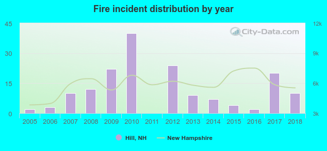 According to the data from the years 2005 - 2018 the average number of fires per year is 12. The highest number of fire incidents - 40 took place in 2010, and the least - 0 in 2011. The data has a growing trend.
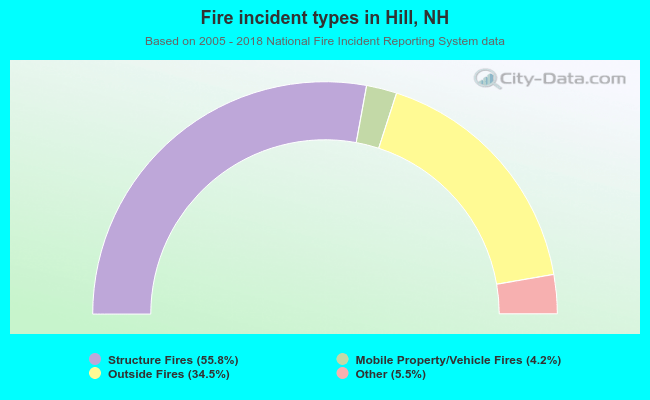 When looking into fire subcategories, the most incidents belonged to: Structure Fires (55.8%), and Outside Fires (34.5%).
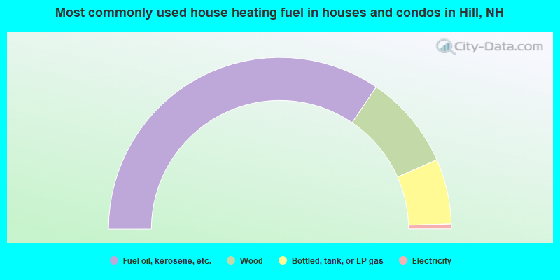
- 69.0%Fuel oil, kerosene, etc.
- 17.8%Wood
- 12.3%Bottled, tank, or LP gas
- 0.9%Electricity
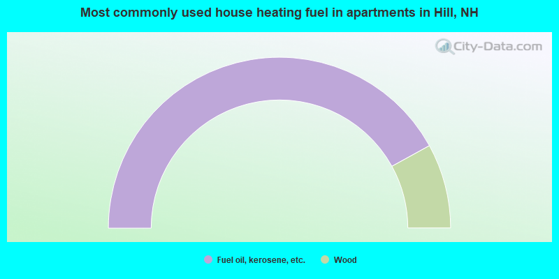
- 84.0%Fuel oil, kerosene, etc.
- 16.0%Wood
Hill compared to New Hampshire state average:
- Unemployed percentage significantly below state average.
- Black race population percentage significantly below state average.
- Hispanic race population percentage significantly below state average.
- Foreign-born population percentage significantly below state average.
- Renting percentage significantly below state average.
- Length of stay since moving in significantly above state average.
- Number of rooms per house significantly below state average.
- House age significantly below state average.
- Number of college students below state average.
- Percentage of population with a bachelor's degree or higher significantly below state average.

|
Total of 4 patent applications in 2008-2024.