Hite, Utah
Submit your own pictures of this place and show them to the world
- OSM Map
- General Map
- Google Map
- MSN Map

| Males: 65 | |
| Females: 55 |
| Median resident age: | 38.3 years |
| Utah median age: | 27.1 years |
Zip code: 84716
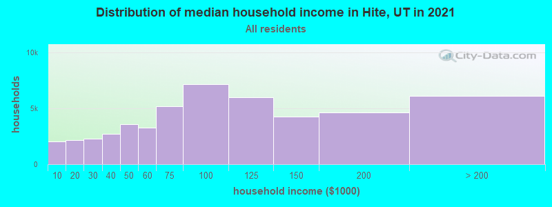
| Hite: | $25,480 |
| UT: | $89,168 |
Estimated per capita income in 2022: $53,724 (it was $23,736 in 2000)
Estimated median house or condo value in 2022: $40,207 (it was $12,500 in 2000)
| Hite: | $40,207 |
| UT: | $499,500 |
Mean prices in 2022: all housing units: $339,490; detached houses: $356,652; townhouses or other attached units: $583,534; mobile homes: $109,299; occupied boats, rvs, vans, etc.: $43,785


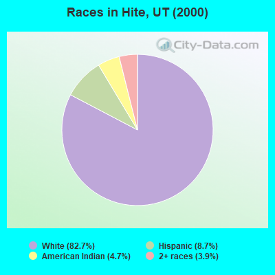
- 10582.7%White alone
- 118.7%Hispanic
- 64.7%American Indian alone
- 53.9%Two or more races
 Recent articles from our blog. Our writers, many of them Ph.D. graduates or candidates, create easy-to-read articles on a wide variety of topics.
Current Local Time: MST time zone
Land area: 1624.8 square miles.
Population density: 0.07 people per square mile (very low).

| Hite CCD: | 0.0% ($0) |
| Utah: | 0.7% ($956) |
Nearest city with pop. 50,000+: Provo, UT  (169.2 miles , pop. 105,166).
Nearest city with pop. 200,000+: Las Vegas, NV (275.1 miles , pop. 478,434).
Nearest city with pop. 1,000,000+: Phoenix, AZ (312.3 miles , pop. 1,321,045).
Nearest cities:
), ), Latitude: 37.91 N, Longitude: 110.72 W
Area code commonly used in this area: 435

| Here: | 9.3% |
| Utah: | 2.5% |
Average climate in Hite, Utah
Based on data reported by over 4,000 weather stations


Earthquake activity:
Hite-area historical earthquake activity is significantly above Utah state average. It is 2341% greater than the overall U.S. average.On 10/3/1915 at 06:52:48, a magnitude 7.6 (7.6 UK, Class: Major, Intensity: VIII - XII) earthquake occurred 404.9 miles away from Hite center
On 6/28/1992 at 11:57:34, a magnitude 7.6 (6.2 MB, 7.6 MS, 7.3 MW, Depth: 0.7 mi) earthquake occurred 414.4 miles away from the city center, causing 3 deaths (1 shaking deaths, 2 other deaths) and 400 injuries, causing $100,000,000 total damage and $40,000,000 insured losses
On 10/16/1999 at 09:46:44, a magnitude 7.4 (6.3 MB, 7.4 MS, 7.2 MW, 7.3 ML) earthquake occurred 395.7 miles away from the city center
On 8/18/1959 at 06:37:13, a magnitude 7.7 (7.7 UK) earthquake occurred 460.5 miles away from Hite center, causing $26,000,000 total damage
On 12/21/1932 at 06:10:09, a magnitude 7.2 (7.2 UK) earthquake occurred 402.1 miles away from the city center
On 7/21/1952 at 11:52:14, a magnitude 7.7 (7.7 UK) earthquake occurred 502.2 miles away from the city center, causing $50,000,000 total damage
Magnitude types: body-wave magnitude (MB), local magnitude (ML), surface-wave magnitude (MS), moment magnitude (MW)
Natural disasters:
The number of natural disasters in Garfield County (5) is a lot smaller than the US average (15).Major Disasters (Presidential) Declared: 2
Emergencies Declared: 2
Causes of natural disasters: Floods: 2, Drought: 1, Hurricane: 1, Landslide: 1, Storm: 1, Winter Storm: 1, Other: 1 (Note: some incidents may be assigned to more than one category).
Colleges/universities with over 2000 students nearest to Hite:
- Snow College (about 111 miles; Ephraim, UT; Full-time enrollment: 3,224)
- Southern Utah University (about 130 miles; Cedar City, UT; FT enrollment: 6,522)
- Colorado Mesa University (about 144 miles; Grand Junction, CO; FT enrollment: 7,671)
- San Juan College (about 162 miles; Farmington, NM; FT enrollment: 5,112)
- Fort Lewis College (about 163 miles; Durango, CO; FT enrollment: 3,631)
- Dixie State University (about 166 miles; Saint George, UT; FT enrollment: 6,485)
- Brigham Young University-Provo (about 170 miles; Provo, UT; FT enrollment: 33,525)
Points of interest:
Notable locations in Hite: Bullfrog Creek Overlook (A), Cedar Mesa Campground (B), Desert Overlook (C), Eagle City (D), Flint Trail Overlook (E), Hog Springs Campground (F), Hog Springs Picnic Area (G), Lake Powell Overlook (H), Little Egypt Geologic Site (I), Little Rockies National Natural Landmark (J), Lonesome Beaver Campground (K), King Ranch (L), McMillan Springs Campground (M), Star Springs Campground (N), Kolb Inscription-1911 (O), Eddy Inscription-1927 (P), Best Inscription-1891 (Q), Sandy Ranch (R), Hog Spring Picnic Area (S), The Post (T). Display/hide their locations on the map
Church in Hite: The Church of Jesus Christ of Latter Day Saints (A). Display/hide its location on the map
Reservoirs: Lost Spring Reservoir (A), Ticaboo Reservoir (B), Bastian Reservoir (C), Cass Creek Reservoir (D), Coyote Reservoir (E), Ticaboo Reservoir (F), Moki Tank (G), Maidenwater Reservoir (H). Display/hide their locations on the map
Streams, rivers, and creeks: South Creek (A), Speck Creek (B), Pistol Creek (C), Maidenwater (D), Star Creek (E), Straight Creek (F), Hansen Creek (G), Swett Creek (H), Gold Creek (I). Display/hide their locations on the map
Parks in Hite include: Painted Hill RV Park (1), Capitol Reef National Park (2). Display/hide their locations on the map
| This place: | 2.1 people |
| Utah: | 3.1 people |
| This place: | 0.0% |
| Whole state: | 77.0% |
| This place: | 11.5% |
| Whole state: | 3.4% |
No gay or lesbian households reported
For population 15 years and over in Hite:
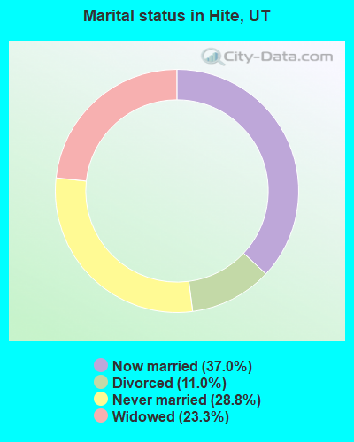
- Never married: 28.8%
- Now married: 37.0%
- Separated: 0.0%
- Widowed: 23.3%
- Divorced: 11.0%
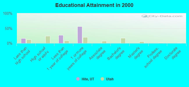
For population 25 years and over in Hite:
- High school or higher: 83.9%
- Bachelor's degree or higher: 0.0%
- Graduate or professional degree: 0.0%
- Mean travel time to work (commute): 3.6 minutes
| Here: | 2.8 |
| Utah average: | 10.5 |
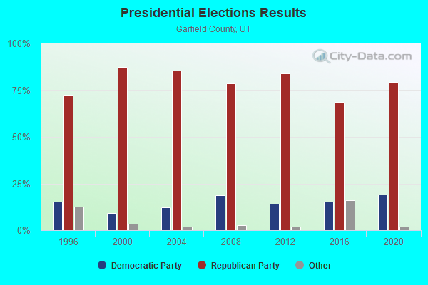
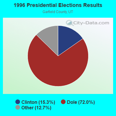
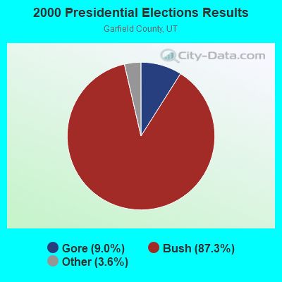
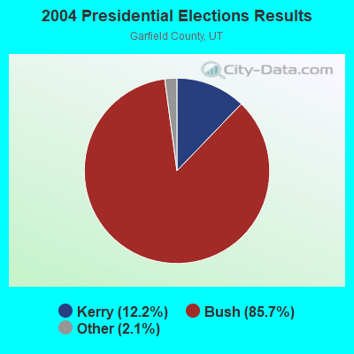
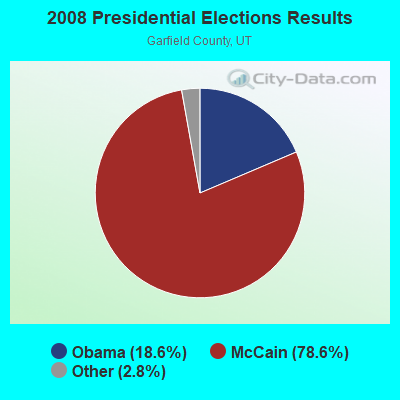
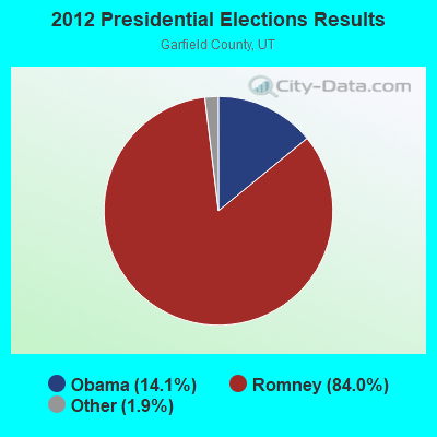
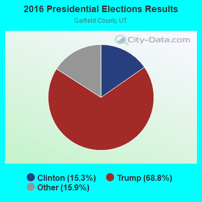
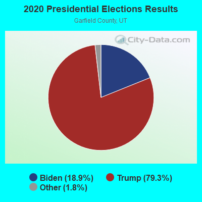
Graphs represent county-level data. Detailed 2008 Election Results
Religion statistics for Hite, UT (based on Garfield County data)
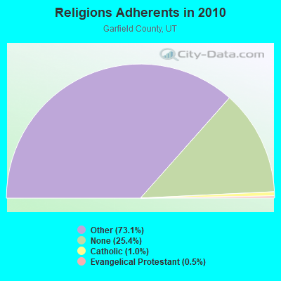
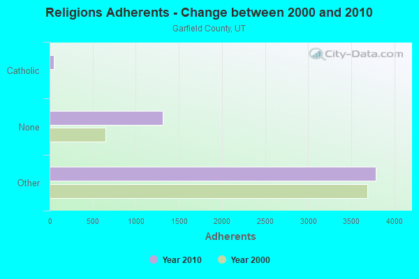
| Religion | Adherents | Congregations |
|---|---|---|
| Other | 3,781 | 15 |
| Catholic | 50 | 1 |
| Evangelical Protestant | 25 | 1 |
| None | 1,316 | - |
Food Environment Statistics:
| This county: | 2.21 / 10,000 pop. |
| Utah: | 1.37 / 10,000 pop. |
| Here: | 2.21 / 10,000 pop. |
| Utah: | 0.41 / 10,000 pop. |
| Here: | 17.67 / 10,000 pop. |
| Utah: | 2.82 / 10,000 pop. |
| Here: | 15.46 / 10,000 pop. |
| State: | 5.09 / 10,000 pop. |
| This county: | 8.4% |
| Utah: | 6.3% |
| Garfield County: | 24.2% |
| Utah: | 23.6% |
Strongest AM radio stations in Hite:
- KTNN (660 AM; 50 kW; WINDOW ROCK, AZ; Owner: THE NAVAJO NATION)
- KNZZ (1100 AM; 50 kW; GRAND JUNCTION, CO; Owner: M B C GRAND BROADCASTING, INC.)
- KALL (700 AM; 50 kW; NORTH SALT LAKE CITY, UT; Owner: CITICASTERS LICENSES, L.P.)
- KHAC (880 AM; 43 kW; TSE BONITO, NM; Owner: WESTERN INDIAN MINISTRIES, INC.)
- KMTI (650 AM; 10 kW; MANTI, UT; Owner: SANPETE COUNTY BROADCASTING COMPANY)
- KIQN (1010 AM; 50 kW; TOOELE, UT)
- KOAL (750 AM; 10 kW; PRICE, UT; Owner: EASTERN UTAH BROADCASTING CO.)
- KSL (1160 AM; 50 kW; SALT LAKE CITY, UT; Owner: BONNEVILLE HOLDING COMPANY)
- KDWN (720 AM; 50 kW; LAS VEGAS, NV; Owner: RADIO NEVADA CORP.)
- KXNT (840 AM; 50 kW; NORTH LAS VEGAS, NV; Owner: INFINITY RADIO OPERATIONS INC.)
- KMIA (710 AM; 50 kW; BLACK CANYON CITY, AZ; Owner: ENTRAVISION HOLDINGS, LLC)
- KJOL (620 AM; 10 kW; GRAND JUNCTION, CO; Owner: UNITED MINISTRIES)
- KSLL (1080 AM; daytime; 10 kW; PRICE, UT; Owner: AGAINST THE WIND BROADCASTING, INC.)
Strongest FM radio stations in Hite:
- K248AJ (97.5 FM; MONTICELLO, UT; Owner: PROCLAIMING CHRIST'S LOVE MINISTRIES)
- K282AC (104.3 FM; RURAL GARFIELD COUNT, UT; Owner: GARFIELD COUNTY)
- K257DL (99.3 FM; TICABOO, UT; Owner: GARFIELD COUNTY)
- K201CF (88.1 FM; TICABOO, UT; Owner: UNIVERSITY OF UTAH)
TV broadcast stations around Hite:
- K02ON (Channel 2; TICABOO, UT; Owner: GARFIELD COUNTY)
- K05JS (Channel 5; TICABOO, UT; Owner: GARFIELD COUNTY)
- K07VE (Channel 7; TICABOO, UT; Owner: GARFIELD COUNTY)
- K04OJ (Channel 4; TICABOO, UT; Owner: GARFIELD COUNTY)
FCC Registered Paging Towers:
1- Along The Coloradoriver, Approx. 5 Miles North Of (Lat: 37.871639 Lon: -110.394861), Call Sign: WDZ406,
Assigned Frequencies: 157.890 MHz, 157.890 MHz, Expiration Date: 11/01/1998, Cancellation Date: 10/26/1999, Registrant: Citizens Utilities Company, 8800 N. Central Expressway, Dallas, TX 75231, Phone: (214) 365-3317
FCC Registered Maritime Coast & Aviation Ground Towers:
1- Hwy 95 (Lat: 37.893056 Lon: -110.367361), Type: Building, Overall height: 4 m, Call Sign: WHX518,
Assigned Frequencies: 156.450 MHz, 156.425 MHz, 156.500 MHz, 156.800 MHz, Grant Date: 05/21/2015, Expiration Date: 06/22/2025, Registrant: Aramark Sports & Entertainment, LLC Dba Lake Powell Resorts & Marinas, 100 Lake Shore Drive, Page, AZ 86040, Phone: (928) 645-1085, Fax: (928) 645-5175, Email:
Hite compared to Utah state average:
- Median household income significantly below state average.
- Median house value significantly below state average.
- Unemployed percentage significantly below state average.
- Black race population percentage significantly below state average.
- Hispanic race population percentage below state average.
- Median age above state average.
- Foreign-born population percentage significantly below state average.
- Renting percentage significantly below state average.
- Length of stay since moving in significantly above state average.
- Number of rooms per house significantly below state average.
- House age significantly below state average.
- Number of college students significantly below state average.
- Percentage of population with a bachelor's degree or higher significantly below state average.