Horse Branch, Kentucky
Submit your own pictures of this place and show them to the world
- OSM Map
- General Map
- Google Map
- MSN Map

| Males: 1,011 | |
| Females: 983 |
| Median resident age: | 37.4 years |
| Kentucky median age: | 35.9 years |
Zip code: 42349
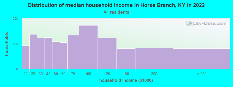
| Horse Branch: | $44,533 |
| KY: | $59,341 |
Estimated per capita income in 2022: $21,973 (it was $12,427 in 2000)
Horse Branch CCD income, earnings, and wages data
Estimated median house or condo value in 2022: $111,775 (it was $45,700 in 2000)
| Horse Branch: | $111,775 |
| KY: | $196,300 |
Detailed information about poverty and poor residents in Horse Branch, KY
Compare current foreclosures near Horse Branch, KY:
| Photo | Address | Area | Beds / Baths | Price | Details |
|---|---|---|---|---|---|

|
#1
Shrader Ln
Fordsville, KY 42343
|
1,268 sq. feet
|
1 baths 2 beds |
$145,000
|
show details |

|
#2
Martin Wilson Rd
Morgantown, KY 42261
|
1,680 sq. feet
|
1 baths 3 beds |
show details | |

|
#3
S Tyler St
Morgantown, KY 42261
|
980 sq. feet
|
1 baths 2 beds |
show details | |

|
#4
Sunset Loop
Morgantown, KY 42261
|
1,008 sq. feet
|
1 baths 3 beds |
show details | |

|
#5
Oak Hill Dr
Morgantown, KY 42261
|
1,144 sq. feet
|
1 baths 3 beds |
show details | |

|
#6
Logansport Rd
Morgantown, KY 42261
|
1,566 sq. feet
|
1 baths 3 beds |
show details | |

|
#7
Brownsville Rd
Morgantown, KY 42261
|
2,096 sq. feet
|
2 baths 3 beds |
show details | |

|
#8
Caneyville Rd
Morgantown, KY 42261
|
960 sq. feet
|
1 baths 3 beds |
show details | |

|
#9
Clark Cemetery Rd
Morgantown, KY 42261
|
1,152 sq. feet
|
2 baths 3 beds |
show details | |

|
#10
Brownsville Rd
Morgantown, KY 42261
|
1,232 sq. feet
|
2 baths 4 beds |
show details |
| Photo | Address | Area | Beds / Baths | Price | Details |
|---|---|---|---|---|---|

|
#11
W Main St
Fordsville, KY 42343
|
- sq. feet
|
- baths - beds |
show details | |

|
#12
Easton Rd
Fordsville, KY 42343
|
- sq. feet
|
- baths - beds |
show details | |

|
#13
W Center St
Hartford, KY 42347
|
- sq. feet
|
- baths - beds |
show details | |

|
#14
Taffy Rd
Hartford, KY 42347
|
- sq. feet
|
- baths - beds |
show details | |

|
#15
Burge Ln
Beaver Dam, KY 42320
|
- sq. feet
|
- baths - beds |
show details | |

|
#16
Silver Beach Rd
Hartford, KY 42347
|
- sq. feet
|
- baths - beds |
show details | |

|
#17
Duff Rd
Falls Of Rough, KY 40119
|
- sq. feet
|
- baths - beds |
show details | |

|
#18
Kentucky 1414
Whitesville, KY 42378
|
- sq. feet
|
- baths - beds |
show details | |

|
#19
Salem Rd
Olaton, KY 42361
|
- sq. feet
|
- baths - beds |
show details | |

|
#20
Blue Bird Rd
Falls Of Rough, KY 40119
|
- sq. feet
|
- baths - beds |
show details |
| Photo | Address | Area | Beds / Baths | Price | Details |
|---|---|---|---|---|---|

|
#21
Kentucky 269
Beaver Dam, KY 42320
|
- sq. feet
|
- baths - beds |
show details | |

|
#22
Silver Beach Rd
Hartford, KY 42347
|
- sq. feet
|
- baths - beds |
show details | |

|
#23
Lone Hill Rd
Falls Of Rough, KY 40119
|
- sq. feet
|
- baths - beds |
show details | |

|
#24
Watershed Rd
Millwood, KY 42762
|
- sq. feet
|
- baths - beds |
show details | |

|
#25
Hilltop Ln
Hartford, KY 42347
|
- sq. feet
|
- baths - beds |
show details | |

|
#26
W Roberts St
Morgantown, KY 42261
|
- sq. feet
|
- baths - beds |
show details | |

|
#27
Kentucky 1414
Hartford, KY 42347
|
- sq. feet
|
- baths - beds |
show details | |

|
#28
S Warren St
Morgantown, KY 42261
|
- sq. feet
|
- baths - beds |
show details | |

|
#29
Smith Hill Dr
Morgantown, KY 42261
|
- sq. feet
|
- baths - beds |
show details | |

|
#30
Jim Embry Dr # 5
Morgantown, KY 42261
|
- sq. feet
|
- baths - beds |
show details |
| Photo | Address | Area | Beds / Baths | Price | Details |
|---|---|---|---|---|---|

|
#31
Jim Embry Dr # 2
Morgantown, KY 42261
|
- sq. feet
|
- baths - beds |
show details | |

|
#32
Easton Cabot Rd
Fordsville, KY 42343
|
- sq. feet
|
- baths - beds |
show details | |

|
#33
Neafus Rd
Morgantown, KY 42261
|
- sq. feet
|
- baths - beds |
show details | |

|
#34
Phelps Coots Rd
Morgantown, KY 42261
|
- sq. feet
|
- baths - beds |
show details | |

|
#35
Thomason Cemetery Rd
Leitchfield, KY 42754
|
- sq. feet
|
- baths - beds |
show details | |

|
#36
Taylors Lake Rd
Morgantown, KY 42261
|
- sq. feet
|
- baths - beds |
show details | |

|
#37
Olaton Rd
Olaton, KY 42361
|
- sq. feet
|
- baths - beds |
show details | |

|
#38
State Route 919
Fordsville, KY 42343
|
- sq. feet
|
- baths - beds |
show details | |

|
#39
Vic Young Rd
Olaton, KY 42361
|
- sq. feet
|
- baths - beds |
show details | |

|
#40
Shultz Rd
Hartford, KY 42347
|
- sq. feet
|
- baths - beds |
show details |
| Photo | Address | Area | Beds / Baths | Price | Details |
|---|---|---|---|---|---|

|
#41
Beaver Dam Rd
Caneyville, KY 42721
|
- sq. feet
|
- baths - beds |
show details | |

|
#42
Kentucky 54
Falls Of Rough, KY 40119
|
- sq. feet
|
- baths - beds |
show details | |

|
#43
State Route 69 N
Hartford, KY 42347
|
- sq. feet
|
- baths - beds |
show details | |

|
#44
Lawrence Hayes Rd
Caneyville, KY 42721
|
- sq. feet
|
- baths - beds |
show details | |

|
#45
Lee Dr
Beaver Dam, KY 42320
|
- sq. feet
|
- baths - beds |
show details | |

|
#46
Oak Ridge Rd
Morgantown, KY 42261
|
- sq. feet
|
- baths - beds |
show details | |

|
#47
Gary Neal Rd
Beaver Dam, KY 42320
|
- sq. feet
|
- baths - beds |
show details | |

|
#48
Barnard Ct
Beaver Dam, KY 42320
|
- sq. feet
|
- baths - beds |
show details | |

|
#49
Embry Heights Dr
Beaver Dam, KY 42320
|
- sq. feet
|
- baths - beds |
show details | |

|
Check over 1 million property listings on Foreclosure.com!
|
browse all offers | |||

- 1,91598.5%White alone
- 90.5%Two or more races
- 50.3%Black alone
- 60.3%Asian alone
- 60.3%Hispanic
- 30.2%American Indian alone
- 10.05%Native Hawaiian and Other
Pacific Islander alone
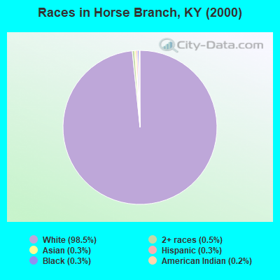
Races in Horse Branch detailed stats: ancestries, foreign born residents, place of birth
According to our research of Kentucky and other state lists, there were 8 registered sex offenders living in Horse Branch, Kentucky as of April 23, 2024.
The ratio of all residents to sex offenders in Horse Branch is 249 to 1.
 Recent articles from our blog. Our writers, many of them Ph.D. graduates or candidates, create easy-to-read articles on a wide variety of topics.
Current Local Time: CST time zone
Land area: 79.6 square miles.
Population density: 25 people per square mile (very low).

| Horse Branch CCD: | 0.5% ($215) |
| Kentucky: | 0.8% ($610) |
Nearest city with pop. 50,000+: Owensboro, KY  (31.7 miles , pop. 54,067).
Nearest city with pop. 200,000+: Louisville, KY (73.9 miles , pop. 256,231).
Nearest city with pop. 1,000,000+: Chicago, IL (307.9 miles , pop. 2,896,016).
Nearest cities:
), ), ), )Latitude: 37.46 N, Longitude: 86.68 W
Area code commonly used in this area: 270

| Here: | 5.7% |
| Kentucky: | 3.8% |
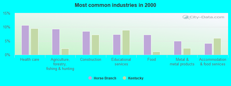
- Health care (10.7%)
- Agriculture, forestry, fishing & hunting (9.3%)
- Construction (8.4%)
- Educational services (7.3%)
- Food (7.2%)
- Metal & metal products (5.0%)
- Accommodation & food services (4.1%)
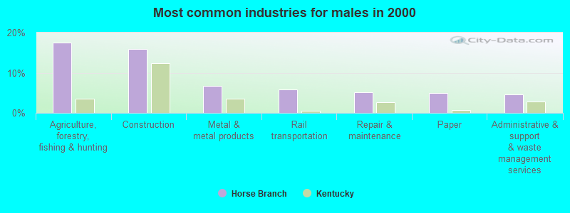
- Agriculture, forestry, fishing & hunting (17.6%)
- Construction (15.9%)
- Metal & metal products (6.8%)
- Rail transportation (5.9%)
- Repair & maintenance (5.2%)
- Paper (4.9%)
- Administrative & support & waste management services (4.7%)
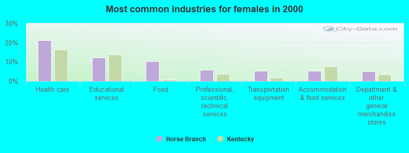
- Health care (21.4%)
- Educational services (12.1%)
- Food (10.3%)
- Professional, scientific, technical services (5.8%)
- Transportation equipment (5.3%)
- Accommodation & food services (5.3%)
- Department & other general merchandise stores (5.0%)
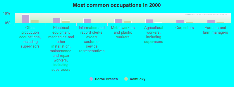
- Other production occupations, including supervisors (8.8%)
- Electrical equipment mechanics and other installation, maintenance, and repair workers, including supervisors (5.3%)
- Information and record clerks, except customer service representatives (4.8%)
- Metal workers and plastic workers (4.1%)
- Agricultural workers, including supervisors (4.0%)
- Carpenters (3.3%)
- Farmers and farm managers (3.1%)
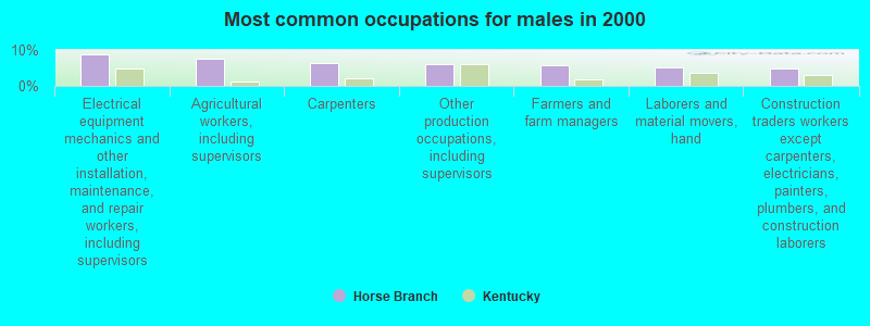
- Electrical equipment mechanics and other installation, maintenance, and repair workers, including supervisors (8.7%)
- Agricultural workers, including supervisors (7.5%)
- Carpenters (6.3%)
- Other production occupations, including supervisors (6.1%)
- Farmers and farm managers (5.9%)
- Laborers and material movers, hand (5.2%)
- Construction traders workers except carpenters, electricians, painters, plumbers, and construction laborers (4.9%)
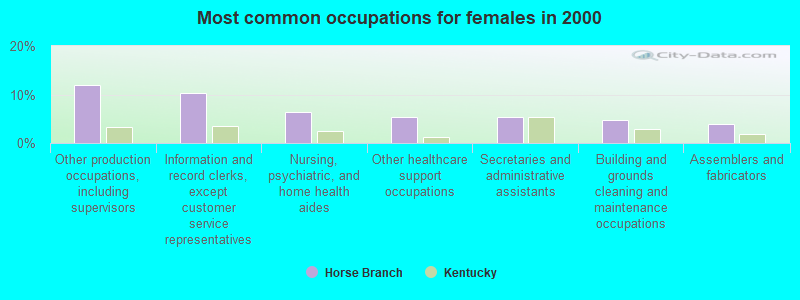
- Other production occupations, including supervisors (11.9%)
- Information and record clerks, except customer service representatives (10.3%)
- Nursing, psychiatric, and home health aides (6.3%)
- Other healthcare support occupations (5.3%)
- Secretaries and administrative assistants (5.3%)
- Building and grounds cleaning and maintenance occupations (4.7%)
- Assemblers and fabricators (4.0%)
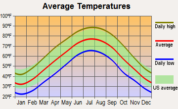
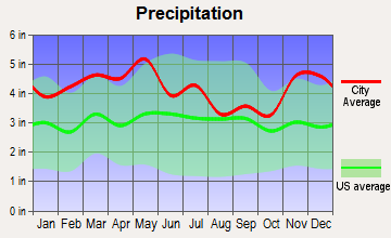
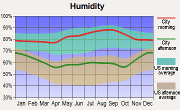
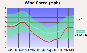
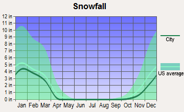
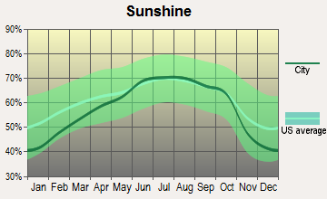
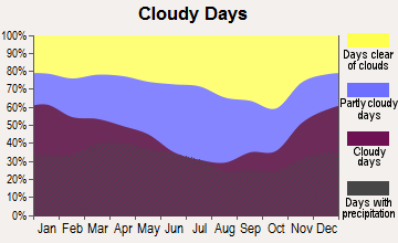
Average climate in Horse Branch, Kentucky
Based on data reported by over 4,000 weather stations
Tornado activity:
Horse Branch-area historical tornado activity is slightly above Kentucky state average. It is 52% greater than the overall U.S. average.
On 4/3/1974, a category F5 (max. wind speeds 261-318 mph) tornado 20.7 miles away from the Horse Branch place center killed 31 people and injured 270 people and caused between $500,000 and $5,000,000 in damages.
On 4/3/1974, a category F4 (max. wind speeds 207-260 mph) tornado 6.7 miles away from the place center injured 2 people.
Earthquake activity:
Horse Branch-area historical earthquake activity is significantly above Kentucky state average. It is 176% greater than the overall U.S. average.On 4/18/2008 at 09:36:59, a magnitude 5.4 (5.1 MB, 4.8 MS, 5.4 MW, 5.2 MW, Class: Moderate, Intensity: VI - VII) earthquake occurred 95.1 miles away from the city center
On 4/18/2008 at 09:36:59, a magnitude 5.2 (5.2 MW, Depth: 8.9 mi) earthquake occurred 95.1 miles away from Horse Branch center
On 6/18/2002 at 17:37:15, a magnitude 5.0 (4.3 MB, 4.6 MW, 5.0 LG) earthquake occurred 70.3 miles away from Horse Branch center
On 6/10/1987 at 23:48:54, a magnitude 5.1 (4.9 MB, 4.4 MS, 4.6 MS, 5.1 LG) earthquake occurred 114.8 miles away from Horse Branch center
On 7/27/1980 at 18:52:21, a magnitude 5.2 (5.1 MB, 4.7 MS, 5.0 UK, 5.2 UK) earthquake occurred 158.4 miles away from Horse Branch center
On 4/18/2008 at 15:14:16, a magnitude 4.8 (4.5 MB, 4.8 MW, 4.6 MW, Class: Light, Intensity: IV - V) earthquake occurred 94.9 miles away from Horse Branch center
Magnitude types: regional Lg-wave magnitude (LG), body-wave magnitude (MB), surface-wave magnitude (MS), moment magnitude (MW)
Natural disasters:
The number of natural disasters in Ohio County (17) is near the US average (15).Major Disasters (Presidential) Declared: 13
Emergencies Declared: 2
Causes of natural disasters: Floods: 11, Storms: 10, Tornadoes: 7, Mudslides: 5, Landslides: 3, Winter Storms: 3, Winds: 2, Blizzard: 1, Hurricane: 1, Snowstorm: 1, Tropical Depression: 1, Other: 1 (Note: some incidents may be assigned to more than one category).
Colleges/universities with over 2000 students nearest to Horse Branch:
- Owensboro Community and Technical College (about 29 miles; Owensboro, KY; Full-time enrollment: 2,754)
- Southcentral Kentucky Community and Technical College (about 35 miles; Bowling Green, KY; FT enrollment: 2,794)
- Western Kentucky University (about 35 miles; Bowling Green, KY; FT enrollment: 16,942)
- Madisonville Community College (about 46 miles; Madisonville, KY; FT enrollment: 2,082)
- Elizabethtown Community and Technical College (about 49 miles; Elizabethtown, KY; FT enrollment: 3,762)
- University of Evansville (about 59 miles; Evansville, IN; FT enrollment: 2,688)
- Hopkinsville Community College (about 60 miles; Hopkinsville, KY; FT enrollment: 2,269)
Public elementary/middle school in Horse Branch:
- HORSE BRANCH ELEMENTARY SCHOOL (Students: 176, Location: 11980 US HWY 62 E, Grades: PK-6)
Points of interest:
Notable locations in Horse Branch: Dan (A), Rosine Fire Department (B). Display/hide their locations on the map
Churches in Horse Branch include: Fairview Church (A), Hopewell Church (B), Leach Chapel (C), New Baymus Church (D), Antioch Church (E), Bethel Church (F), Saint Johns Church (G), Salem Church (H), Cane Run Church (I). Display/hide their locations on the map
Cemeteries: McCord Cemetery (1), Wilson Cemetery (2), Arnold Ridge Cemetery (3), Axton Cemetery (4), Voyles Cemetery (5), Wade Cemetery (6), Ferguson Cemetery (7). Display/hide their locations on the map
Streams, rivers, and creeks: Browns Creek (A), Brush Run (B), Cow Creek (C), Sled Run (D), McGrady Creek (E), Muddy Creek (F), Jenny Branch (G), Richland Creek (H), Horse Branch (I). Display/hide their locations on the map
| This place: | 2.6 people |
| Kentucky: | 2.5 people |
| This place: | 73.6% |
| Whole state: | 66.9% |
| This place: | 5.4% |
| Whole state: | 6.4% |
Likely homosexual households (counted as self-reported same-sex unmarried-partner households)
- Lesbian couples: 0.8% of all households
- Gay men: 0.1% of all households
| This place: | 21.2% |
| Whole state: | 15.8% |
| This place: | 5.9% |
| Whole state: | 6.6% |
For population 15 years and over in Horse Branch:
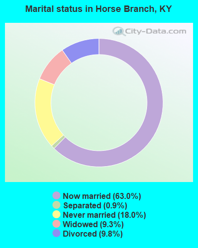
- Never married: 18.0%
- Now married: 63.0%
- Separated: 0.9%
- Widowed: 9.3%
- Divorced: 9.8%
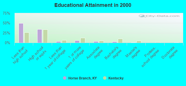
For population 25 years and over in Horse Branch:
- High school or higher: 50.4%
- Bachelor's degree or higher: 4.0%
- Graduate or professional degree: 0.9%
- Unemployed: 2.1%
- Mean travel time to work (commute): 36.8 minutes
| Here: | 14.4 |
| Kentucky average: | 13.8 |
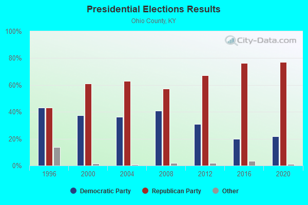
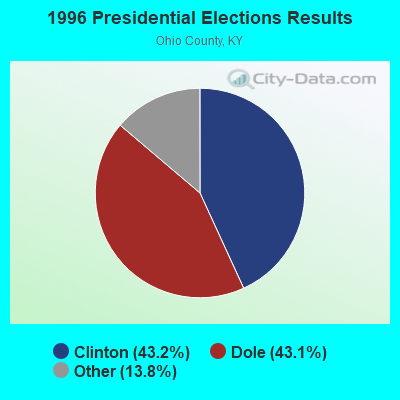
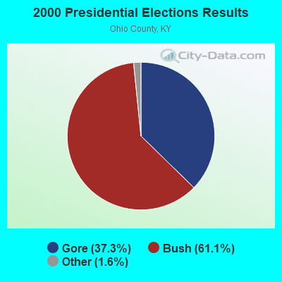
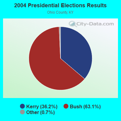
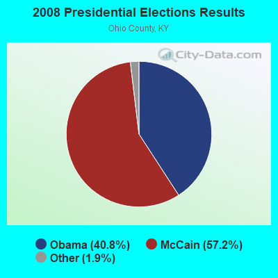
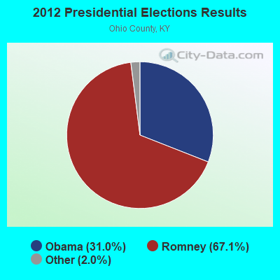
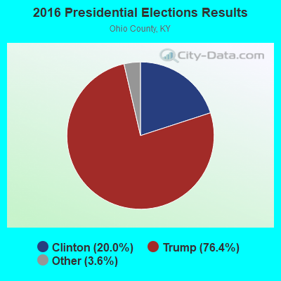
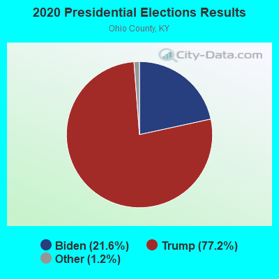
Graphs represent county-level data. Detailed 2008 Election Results
Religion statistics for Horse Branch, KY (based on Ohio County data)
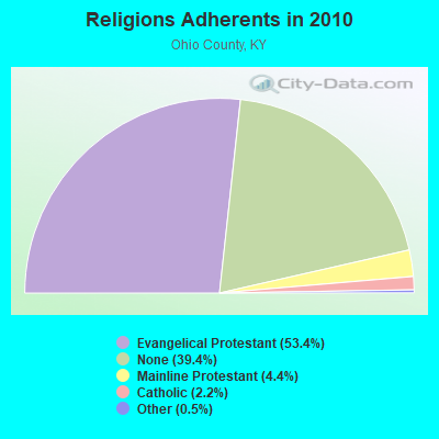
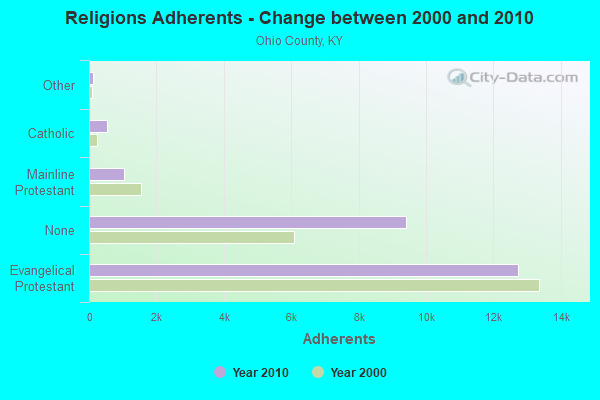
| Religion | Adherents | Congregations |
|---|---|---|
| Evangelical Protestant | 12,741 | 65 |
| Mainline Protestant | 1,042 | 15 |
| Catholic | 530 | 2 |
| Other | 125 | 2 |
| None | 9,404 | - |
Food Environment Statistics:
| Here: | 1.27 / 10,000 pop. |
| State: | 2.19 / 10,000 pop. |
| Ohio County: | 0.42 / 10,000 pop. |
| State: | 0.25 / 10,000 pop. |
| This county: | 2.97 / 10,000 pop. |
| State: | 4.36 / 10,000 pop. |
| Ohio County: | 5.10 / 10,000 pop. |
| State: | 5.74 / 10,000 pop. |
| Ohio County: | 13.1% |
| Kentucky: | 11.0% |
| Ohio County: | 31.5% |
| Kentucky: | 30.0% |
| Ohio County: | 15.8% |
| Kentucky: | 15.9% |
Strongest AM radio stations in Horse Branch:
- WHAS (840 AM; 50 kW; LOUISVILLE, KY; Owner: CLEAR CHANNEL BROADCASTING LICENSES, INC.)
- WSM (650 AM; 50 kW; NASHVILLE, TN; Owner: GAYLORD ENTERTAINMENT COMPANY)
- WKDA (1200 AM; 50 kW; NASHVILLE, TN; Owner: RADIO NASHVILLE, INC.)
- WAMB (1160 AM; 50 kW; DONELSON, TN; Owner: GREAT SOUTHERN BROADCASTING COMPANY, INC.)
- WNQM (1300 AM; 50 kW; NASHVILLE, TN; Owner: WNQM. INC.)
- WKCT (930 AM; 5 kW; BOWLING GREEN, KY; Owner: DAILY NEWS BROADCASTING CO.)
- WLAC (1510 AM; 50 kW; NASHVILLE, TN; Owner: CAPSTAR TX LIMITED PARTNERSHIP)
- WAIA (1600 AM; 1 kW; BEAVER DAM, KY; Owner: STARLIGHT BROADCASTING CO., INC.)
- WVJS (1420 AM; 5 kW; OWENSBORO, KY; Owner: TSB III, LLC)
- WLBQ (1570 AM; 1 kW; MORGANTOWN, KY; Owner: BUTLER COUNTY BROADCASTING CO.)
- WKCM (1160 AM; 2 kW; HAWESVILLE, KY; Owner: HANCOCK COMMUNICATIONS, INC.)
- WLW (700 AM; 50 kW; CINCINNATI, OH; Owner: JACOR BROADCASTING CORPORATION)
- WWAM (820 AM; daytime; 50 kW; JASPER, TN; Owner: SHELTON BROADCASTING SYSTEM)
Strongest FM radio stations in Horse Branch:
- WBKR (92.5 FM; OWENSBORO, KY; Owner: REGENT BROADCASTING OF EVANSVILLE/OWENSBORO, INC.)
- WXMZ (106.3 FM; HARTFORD, KY; Owner: STARLIGHT BROADCASTING CO., INC.)
- WQXQ (101.9 FM; CENTRAL CITY, KY; Owner: STARLIGHT BROADCASTING CO., INC.)
- WUBT (101.1 FM; RUSSELLVILLE, KY; Owner: CAPSTAR TX LIMITED PARTNERSHIP)
- WXCM (97.1 FM; HAWESVILLE, KY; Owner: WLME, INC.)
- WLME (102.9 FM; CANNELTON, IN; Owner: HANCOCK COMMUNICATIONS, INC)
- WKLX (100.7 FM; BROWNSVILLE, KY; Owner: CHARLES M. ANDERSON)
- WKYU-FM (88.9 FM; BOWLING GREEN, KY; Owner: WESTERN KENTUCKY UNIVERSITY)
- WTCJ-FM (105.7 FM; TELL CITY, IN; Owner: HANCOCK COMMUNICATIONS, INC.)
- WSTO (96.1 FM; OWENSBORO, KY; Owner: TSB III, LLC)
- WBFI (91.5 FM; MCDANIELS, KY; Owner: BETHEL FELLOWSHIP, INC.)
- WXBC (104.3 FM; HARDINSBURG, KY; Owner: BRECKINRIDGE BROADCASTING CO., INC.)
- WBIO (94.7 FM; PHILPOT, KY; Owner: THE CROMWELL GROUP, INC OF KENTUCKY)
- WKHG (104.9 FM; LEITCHFIELD, KY; Owner: HERITAGE MEDIA OF KENTUCKY INC)
TV broadcast stations around Horse Branch:
- W62CJ (Channel 62; JACKSON, TN; Owner: MS COMMUNICATIONS, LLC)
- WKGB-TV (Channel 53; BOWLING GREEN, KY; Owner: KENTUCKY AUTHORITY FOR EDUCATIONAL TV)
- WBKO (Channel 13; BOWLING GREEN, KY; Owner: GRAY MIDAMERICA TV LICENSEE CORP.)
- WKYU-TV (Channel 24; BOWLING GREEN, KY; Owner: WESTERN KENTUCKY UNIVERSITY)
Horse Branch fatal accident list:
FCC Registered Cell Phone Towers:
1 (See the full list of FCC Registered Cell Phone Towers in Horse Branch)FCC Registered Antenna Towers:
38 (See the full list of FCC Registered Antenna Towers)FCC Registered Microwave Towers:
1- Ohio West KY, 3893 State Route 505 South (Lat: 37.405278 Lon: -86.704722), Type: Ltower, Structure height: 89 m, Overall height: 94.5 m, Call Sign: WQTL384,
Assigned Frequencies: 6315.84 MHz, Grant Date: 02/26/2014, Expiration Date: 02/26/2024, Cancellation Date: 11/30/2023, Certifier: Gregory M Romano, Registrant: Verizon, 1300 I Street, Nw - Suite 500 East, Washington, DC 20005, Phone: (202) 515-2453, Email:
FCC Registered Amateur Radio Licenses:
2- Call Sign: WA4UGG, Licensee ID: L01300557, Grant Date: 05/17/2017, Expiration Date: 08/12/2027, Certifier: Donald R Davis Sr, Registrant: Donald R Davis Sr, 20855 Beaver Dam Road, Horse Branch, KY 42349-9611
- Call Sign: KK4ZSN, Licensee ID: L01853212, Grant Date: 03/27/2014, Expiration Date: 03/27/2024, Certifier: Ethan E Eadens, Registrant: Ethan E Eadens, 1722 St Rt 2713, Horse Branch, KY 42349
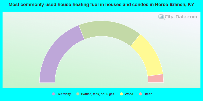
- 38.0%Electricity
- 33.3%Bottled, tank, or LP gas
- 24.2%Wood
- 2.6%Fuel oil, kerosene, etc.
- 1.8%Coal or coke
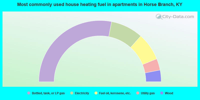
- 56.1%Bottled, tank, or LP gas
- 17.1%Electricity
- 14.6%Fuel oil, kerosene, etc.
- 6.1%Utility gas
- 6.1%Wood
Horse Branch compared to Kentucky state average:
- Median house value below state average.
- Unemployed percentage significantly below state average.
- Black race population percentage significantly below state average.
- Hispanic race population percentage significantly below state average.
- Foreign-born population percentage significantly below state average.
- Renting percentage below state average.
- Length of stay since moving in significantly above state average.
- Number of rooms per house significantly below state average.
- House age significantly below state average.
- Percentage of population with a bachelor's degree or higher significantly below state average.