Huston, Idaho
Huston: Huston, Idaho
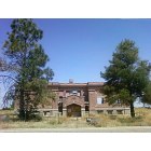
Huston: Huston School - Huston, Idaho
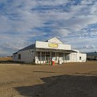
Huston: The Old Houston Idaho Grocery Store
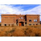
Huston: Houston School...Houston Idaho....2012
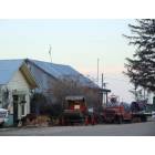
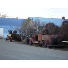
Huston: Huston, Idaho
- add
your
Submit your own pictures of this place and show them to the world
- OSM Map
- General Map
- Google Map
- MSN Map

| Males: 2,181 | |
| Females: 2,062 |
| Median resident age: | 34.1 years |
| Idaho median age: | 33.2 years |
Zip code: 83607
| Huston: | $79,559 |
| ID: | $72,785 |
Estimated per capita income in 2022: $34,279 (it was $17,577 in 2000)
Huston CCD income, earnings, and wages data
Estimated median house or condo value in 2022: $486,737 (it was $114,800 in 2000)
| Huston: | $486,737 |
| ID: | $432,500 |
Mean prices in 2022: all housing units: $336,271; detached houses: $351,841; townhouses or other attached units: $317,376; in 2-unit structures: $215,733; in 3-to-4-unit structures: $211,494; in 5-or-more-unit structures: $370,076; mobile homes: $118,732; occupied boats, rvs, vans, etc.: $112,271
Detailed information about poverty and poor residents in Huston, ID
Compare current foreclosures near Huston, ID:
| Photo | Address | Area | Beds / Baths | Price | Details |
|---|---|---|---|---|---|

|
#1
Hudson Dr
Nampa, ID 83651
|
1,716 sq. feet
|
2 baths 4 beds |
show details | |

|
#2
Nanticoke Ave
Caldwell, ID 83605
|
2,025 sq. feet
|
2 baths 4 beds |
show details | |

|
#3
Raintree Dr
Nampa, ID 83686
|
1,742 sq. feet
|
3 baths 3 beds |
show details | |

|
#4
E Caspian Dr
Nampa, ID 83687
|
1,650 sq. feet
|
2 baths 4 beds |
show details | |

|
#5
E Victory Rd
Nampa, ID 83687
|
3,836 sq. feet
|
1 baths 2 beds |
show details | |

|
#6
W Cannon River St
Nampa, ID 83686
|
2,530 sq. feet
|
2 baths 4 beds |
show details | |

|
#7
Jacks Rd
Parma, ID 83660
|
2,340 sq. feet
|
3 baths 5 beds |
show details | |

|
#8
Vine St
Middleton, ID 83644
|
1,524 sq. feet
|
1 baths 3 beds |
show details | |

|
#9
E Sherman Ave
Nampa, ID 83686
|
896 sq. feet
|
1 baths 2 beds |
show details | |

|
#10
E Harpster Ct
Nampa, ID 83687
|
- sq. feet
|
2 baths 4 beds |
show details |
| Photo | Address | Area | Beds / Baths | Price | Details |
|---|---|---|---|---|---|

|
#11
S Diamond St
Nampa, ID 83686
|
632 sq. feet
|
1 baths 2 beds |
show details | |

|
#12
Kennebec Way
Caldwell, ID 83605
|
2,526 sq. feet
|
2 baths 4 beds |
show details | |

|
#13
N Montana Ave
Caldwell, ID 83605
|
2,408 sq. feet
|
3 baths 4 beds |
show details | |

|
#14
Roanoke Dr
Caldwell, ID 83605
|
1,261 sq. feet
|
2 baths 3 beds |
show details | |

|
#15
Nixon Ave
Nampa, ID 83686
|
1,855 sq. feet
|
2 baths 3 beds |
show details | |

|
#16
Terrace Dr
Caldwell, ID 83605
|
1,358 sq. feet
|
2 baths 3 beds |
show details | |

|
#17
16th Ave N
Nampa, ID 83687
|
1,376 sq. feet
|
1 baths 2 beds |
show details | |

|
#18
Pembrook Ave
Caldwell, ID 83605
|
1,523 sq. feet
|
2 baths 3 beds |
show details | |

|
#19
Taft St
Caldwell, ID 83605
|
1,404 sq. feet
|
1 baths 3 beds |
show details | |

|
#20
Notus Rd
Caldwell, ID 83607
|
1,216 sq. feet
|
1 baths 2 beds |
show details |
| Photo | Address | Area | Beds / Baths | Price | Details |
|---|---|---|---|---|---|

|
#21
N La Cresta Ave
Caldwell, ID 83605
|
960 sq. feet
|
1 baths 3 beds |
show details | |

|
#22
Chicago St
Nampa, ID 83686
|
1,702 sq. feet
|
2 baths 3 beds |
show details | |

|
#23
Banner St
Nampa, ID 83686
|
3,452 sq. feet
|
3 baths 3 beds |
show details | |

|
#24
E Locust Ln
Nampa, ID 83686
|
1,472 sq. feet
|
2 baths 3 beds |
show details | |

|
#25
4th St N
Nampa, ID 83687
|
768 sq. feet
|
1 baths 2 beds |
show details | |

|
#26
Nectarine St
Nampa, ID 83686
|
726 sq. feet
|
1 baths 2 beds |
show details | |

|
#27
Nectarine St
Nampa, ID 83686
|
1,282 sq. feet
|
1 baths 3 beds |
show details | |

|
#28
S Canyon St
Nampa, ID 83686
|
2,393 sq. feet
|
2 baths 3 beds |
show details | |

|
#29
Challis Pl
Caldwell, ID 83605
|
2,129 sq. feet
|
2 baths 4 beds |
show details | |

|
#30
W Patel Dr
Meridian, ID 83646
|
1,806 sq. feet
|
3 baths 4 beds |
show details |
| Photo | Address | Area | Beds / Baths | Price | Details |
|---|---|---|---|---|---|

|
#31
S Stonehedge Dr
Nampa, ID 83686
|
1,508 sq. feet
|
2 baths 3 beds |
show details | |

|
#32
S Pit Ln
Nampa, ID 83687
|
2,223 sq. feet
|
3 baths 3 beds |
show details | |

|
#33
W Trini Dr
Kuna, ID 83634
|
1,176 sq. feet
|
2 baths 3 beds |
show details | |

|
#34
W Wave Dr
Meridian, ID 83642
|
1,481 sq. feet
|
2 baths 3 beds |
show details | |

|
#35
N Center St
Star, ID 83669
|
994 sq. feet
|
1 baths 3 beds |
show details | |

|
#36
N Silverleaf Way
Meridian, ID 83646
|
1,956 sq. feet
|
2 baths 3 beds |
show details | |

|
#37
W Topanga Dr
Kuna, ID 83634
|
1,136 sq. feet
|
2 baths 3 beds |
show details | |

|
#38
N Maroon Ave
Kuna, ID 83634
|
1,972 sq. feet
|
2 baths 3 beds |
show details | |

|
#39
Purple Sage Rd, Trlr 30
Caldwell, ID 83607
|
672 sq. feet
|
1 baths 2 beds |
show details | |

|
#40
W Halverson St
Middleton, ID 83644
|
1,620 sq. feet
|
2 baths 4 beds |
show details |
| Photo | Address | Area | Beds / Baths | Price | Details |
|---|---|---|---|---|---|

|
#41
Southwell Ct
Middleton, ID 83644
|
2,509 sq. feet
|
2 baths 4 beds |
show details | |

|
#42
N Gentry Dr
Nampa, ID 83687
|
1,777 sq. feet
|
2 baths 3 beds |
show details | |

|
#43
N Sugar St
Nampa, ID 83687
|
1,505 sq. feet
|
2 baths 3 beds |
show details | |

|
#44
Elton Ln
Caldwell, ID 83607
|
1,203 sq. feet
|
2 baths 3 beds |
show details | |

|
#45
E Wiltshire Ln
Nampa, ID 83687
|
1,640 sq. feet
|
2 baths 4 beds |
show details | |

|
#46
N Wessex Ln
Nampa, ID 83687
|
1,144 sq. feet
|
2 baths 3 beds |
show details | |

|
#47
S Winterberry Ct
Nampa, ID 83687
|
1,705 sq. feet
|
2 baths 3 beds |
show details | |

|
#48
E Greensprings Ct
Nampa, ID 83686
|
1,423 sq. feet
|
2 baths 4 beds |
show details | |

|
#49
E Mckenzre St
Nampa, ID 83687
|
1,390 sq. feet
|
2 baths 3 beds |
show details | |

|
Check over 1 million property listings on Foreclosure.com!
|
browse all offers | |||

- 2,49779.1%White alone
- 56117.8%Hispanic
- 471.5%Two or more races
- 200.6%American Indian alone
- 180.6%Asian alone
- 100.3%Black alone
- 30.09%Native Hawaiian and Other
Pacific Islander alone - 20.06%Other race alone
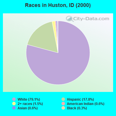
Races in Huston detailed stats: ancestries, foreign born residents, place of birth
 Recent articles from our blog. Our writers, many of them Ph.D. graduates or candidates, create easy-to-read articles on a wide variety of topics.
Current Local Time: MST time zone
Elevation: 2515 feet
Land area: 70.5 square miles.
Population density: 60 people per square mile (very low).

| Huston CCD: | 1.0% ($1,120) |
| Idaho: | 1.0% ($1,007) |
Nearest city with pop. 50,000+: Nampa, ID  (10.0 miles , pop. 51,867).
Nearest city with pop. 200,000+: Northwest Clackamas, OR (316.3 miles , pop. 224,220).
Nearest city with pop. 1,000,000+: Los Angeles, CA (659.9 miles , pop. 3,694,820).
Nearest cities:
), ), Latitude: 43.54 N, Longitude: 116.76 W
Area code commonly used in this area: 208

| Here: | 3.5% |
| Idaho: | 3.1% |
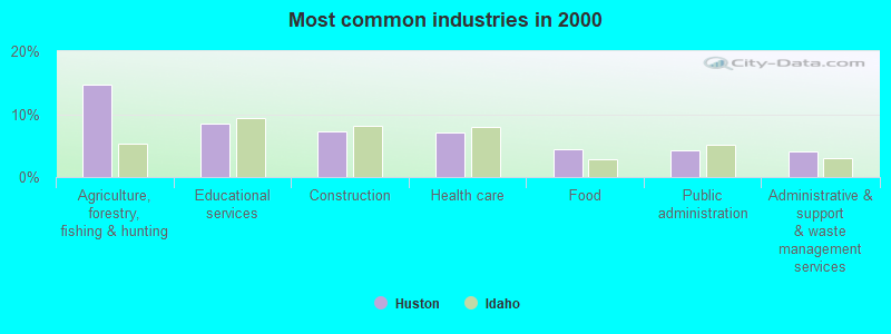
- Agriculture, forestry, fishing & hunting (14.7%)
- Educational services (8.4%)
- Construction (7.3%)
- Health care (7.0%)
- Food (4.4%)
- Public administration (4.3%)
- Administrative & support & waste management services (4.1%)
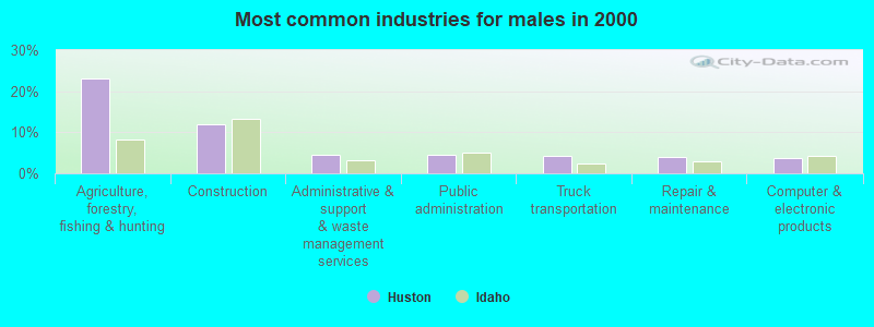
- Agriculture, forestry, fishing & hunting (23.0%)
- Construction (11.9%)
- Administrative & support & waste management services (4.6%)
- Public administration (4.5%)
- Truck transportation (4.2%)
- Repair & maintenance (3.9%)
- Computer & electronic products (3.7%)
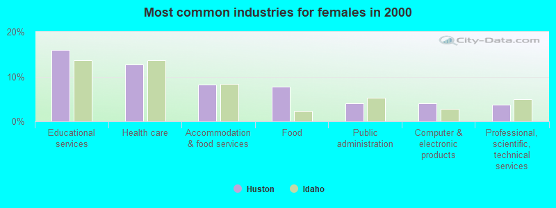
- Educational services (15.9%)
- Health care (12.6%)
- Accommodation & food services (8.2%)
- Food (7.7%)
- Public administration (4.0%)
- Computer & electronic products (4.0%)
- Professional, scientific, technical services (3.7%)
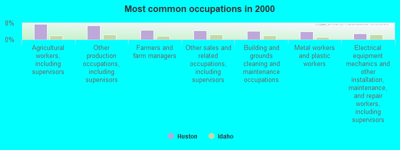
- Agricultural workers, including supervisors (7.4%)
- Other production occupations, including supervisors (6.8%)
- Farmers and farm managers (4.7%)
- Other sales and related occupations, including supervisors (4.4%)
- Building and grounds cleaning and maintenance occupations (4.1%)
- Metal workers and plastic workers (4.0%)
- Electrical equipment mechanics and other installation, maintenance, and repair workers, including supervisors (2.9%)
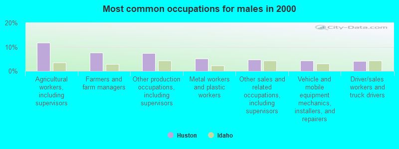
- Agricultural workers, including supervisors (11.8%)
- Farmers and farm managers (7.7%)
- Other production occupations, including supervisors (7.5%)
- Metal workers and plastic workers (5.1%)
- Other sales and related occupations, including supervisors (4.7%)
- Vehicle and mobile equipment mechanics, installers, and repairers (4.3%)
- Driver/sales workers and truck drivers (4.1%)
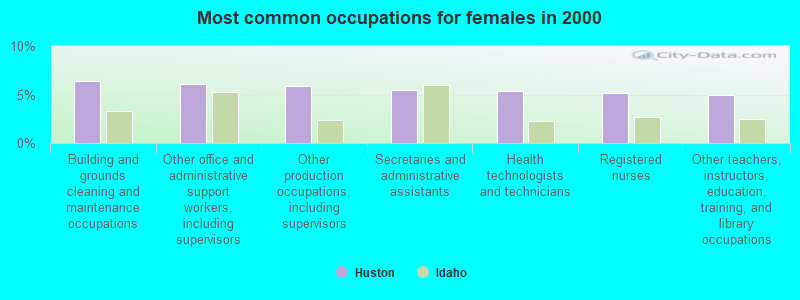
- Building and grounds cleaning and maintenance occupations (6.4%)
- Other office and administrative support workers, including supervisors (6.0%)
- Other production occupations, including supervisors (5.9%)
- Secretaries and administrative assistants (5.5%)
- Health technologists and technicians (5.3%)
- Registered nurses (5.1%)
- Other teachers, instructors, education, training, and library occupations (4.9%)
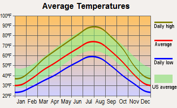
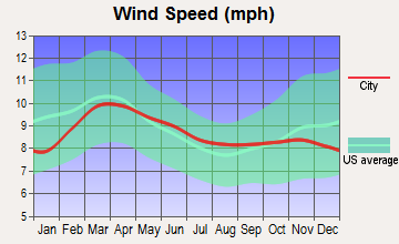
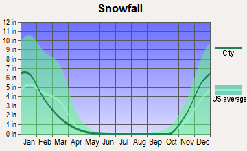
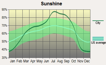
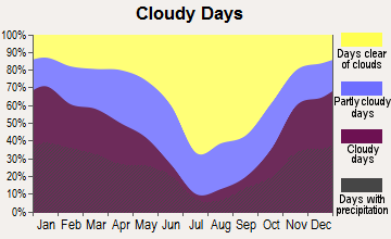
Average climate in Huston, Idaho
Based on data reported by over 4,000 weather stations
(lower is better)
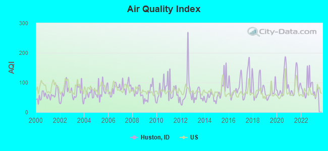
Air Quality Index (AQI) level in 2022 was 89.6. This is worse than average.
| City: | 89.6 |
| U.S.: | 72.6 |
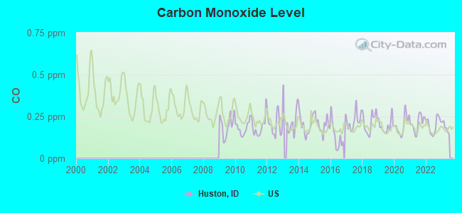
Carbon Monoxide (CO) [ppm] level in 2022 was 0.198. This is better than average. Closest monitor was 20.9 miles away from the city center.
| City: | 0.198 |
| U.S.: | 0.251 |
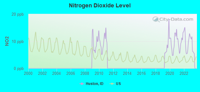
Nitrogen Dioxide (NO2) [ppb] level in 2022 was 9.98. This is significantly worse than average. Closest monitor was 20.9 miles away from the city center.
| City: | 9.98 |
| U.S.: | 5.11 |
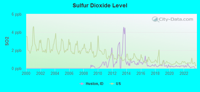
Sulfur Dioxide (SO2) [ppb] level in 2022 was 0.238. This is significantly better than average. Closest monitor was 20.9 miles away from the city center.
| City: | 0.238 |
| U.S.: | 1.515 |
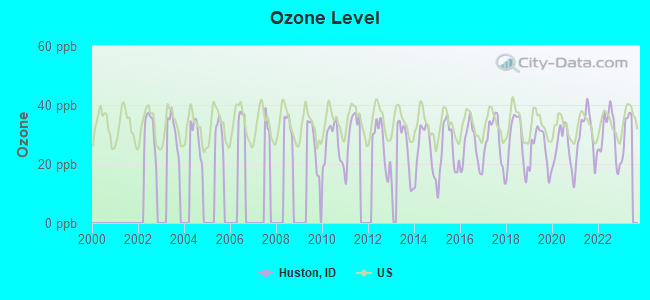
Ozone [ppb] level in 2022 was 29.7. This is about average. Closest monitor was 13.0 miles away from the city center.
| City: | 29.7 |
| U.S.: | 33.3 |
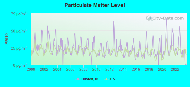
Particulate Matter (PM10) [µg/m3] level in 2022 was 29.1. This is significantly worse than average. Closest monitor was 9.8 miles away from the city center.
| City: | 29.1 |
| U.S.: | 19.2 |
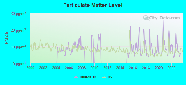
Particulate Matter (PM2.5) [µg/m3] level in 2022 was 9.17. This is about average. Closest monitor was 9.8 miles away from the city center.
| City: | 9.17 |
| U.S.: | 8.11 |
Earthquake activity:
Huston-area historical earthquake activity is significantly above Idaho state average. It is 2316% greater than the overall U.S. average.On 10/3/1915 at 06:52:48, a magnitude 7.6 (7.6 UK, Class: Major, Intensity: VIII - XII) earthquake occurred 214.0 miles away from Huston center
On 10/28/1983 at 14:06:06, a magnitude 7.3 (6.2 MB, 7.3 MS, 7.0 MW) earthquake occurred 152.1 miles away from Huston center, causing 2 deaths (2 shaking deaths) and 3 injuries, causing $15,000,000 total damage
On 8/18/1959 at 06:37:13, a magnitude 7.7 (7.7 UK) earthquake occurred 311.4 miles away from the city center, causing $26,000,000 total damage
On 3/31/2020 at 23:52:30, a magnitude 6.5 (6.5 MW, Depth: 7.5 mi, Class: Strong, Intensity: VII - IX) earthquake occurred 103.5 miles away from Huston center
On 12/16/1954 at 11:07:12, a magnitude 7.0 (7.0 UK) earthquake occurred 307.3 miles away from the city center
On 12/21/1932 at 06:10:09, a magnitude 7.2 (7.2 UK) earthquake occurred 355.0 miles away from Huston center
Magnitude types: body-wave magnitude (MB), surface-wave magnitude (MS), moment magnitude (MW)
Natural disasters:
The number of natural disasters in Canyon County (3) is a lot smaller than the US average (15).Emergencies Declared: 1
Causes of natural disasters: Flood: 1, Hurricane: 1, Other: 1 (Note: some incidents may be assigned to more than one category).
Hospitals and medical centers near Huston:
- KINDRED NURSING AND REHAB - CANYON WEST (Nursing Home, about 9 miles away; CALDWELL, ID)
- WEST VALLEY MEDICAL CENTER Acute Care Hospitals (about 9 miles away; CALDWELL, ID)
- TRINITY MISSION HEALTH AND REHAB OF MIDLAND (Nursing Home, about 9 miles away; NAMPA, ID)
- KINDRED NURSING AND REHAB - NAMPA (Nursing Home, about 10 miles away; NAMPA, ID)
- KARCHER ESTATES (Nursing Home, about 10 miles away; NAMPA, ID)
- KINDRED NURSING AND REHAB - CALDWELL (Nursing Home, about 10 miles away; CALDWELL, ID)
- LIBERTY DIALYSIS - NAMPA (Dialysis Facility, about 10 miles away; NAMPA, ID)
Heliports located in Huston:
Colleges/universities with over 2000 students nearest to Huston:
- Northwest Nazarene University (about 10 miles; Nampa, ID; Full-time enrollment: 2,290)
- College of Western Idaho (about 14 miles; Nampa, ID; FT enrollment: 6,300)
- Boise State University (about 28 miles; Boise, ID; FT enrollment: 16,774)
- Treasure Valley Community College (about 35 miles; Ontario, OR; FT enrollment: 2,055)
- College of Southern Idaho (about 134 miles; Twin Falls, ID; FT enrollment: 5,051)
- Eastern Oregon University (about 140 miles; La Grande, OR; FT enrollment: 3,127)
- Walla Walla Community College (about 191 miles; Walla Walla, WA; FT enrollment: 4,263)
Points of interest:
Notable location: Demke Pipeline (A). Display/hide its location on the map
Reservoir: Lake Lowell (A). Display/hide its location on the map
Drinking water stations with addresses in Huston and their reported violations in the past:
RIVER VIEW FARMS (Population served: 35, Groundwater):Past health violations:Past monitoring violations:
- MCL, Monthly (TCR) - Between APR-2006 and JUN-2006, Contaminant: Coliform. Follow-up actions: St Public Notif requested (MAY-12-2006), St Public Notif received (MAY-19-2006)
- One routine major monitoring violation
| This place: | 3.0 people |
| Idaho: | 2.7 people |
| This place: | 81.5% |
| Whole state: | 69.6% |
| This place: | 3.6% |
| Whole state: | 6.3% |
Likely homosexual households (counted as self-reported same-sex unmarried-partner households)
- Lesbian couples: 0.3% of all households
- Gay men: 0.2% of all households
| This place: | 4.6% |
| Whole state: | 11.8% |
| This place: | 2.2% |
| Whole state: | 4.6% |
For population 15 years and over in Huston:
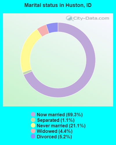
- Never married: 21.1%
- Now married: 69.3%
- Separated: 1.1%
- Widowed: 4.4%
- Divorced: 5.2%
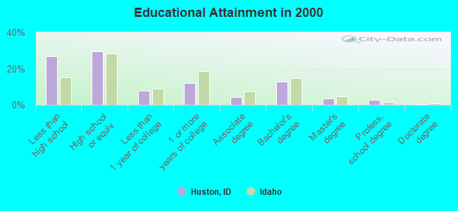
For population 25 years and over in Huston:
- High school or higher: 73.0%
- Bachelor's degree or higher: 19.4%
- Graduate or professional degree: 6.6%
- Unemployed: 5.3%
- Mean travel time to work (commute): 26.6 minutes
| Here: | 16.1 |
| Idaho average: | 11.1 |
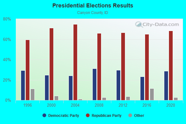
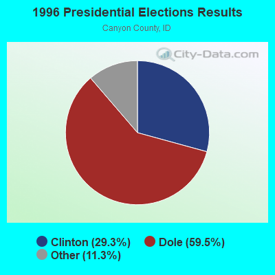
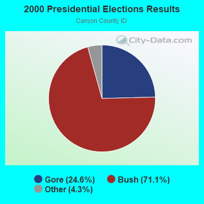

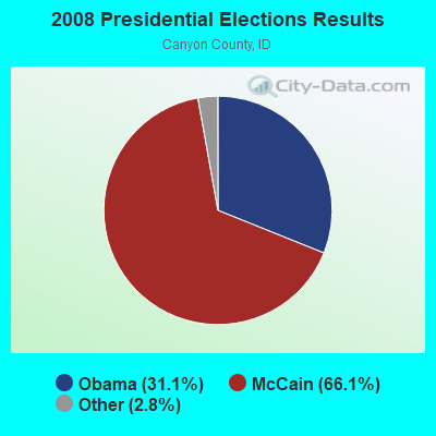
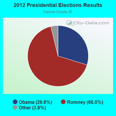

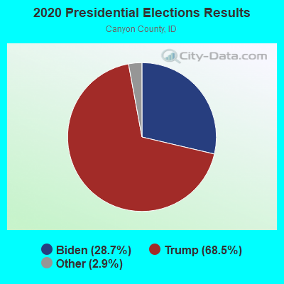
Graphs represent county-level data. Detailed 2008 Election Results
Religion statistics for Huston, ID (based on Canyon County data)
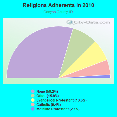
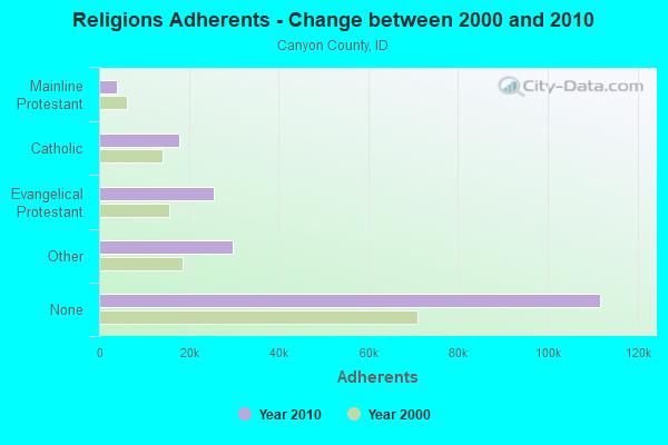
| Religion | Adherents | Congregations |
|---|---|---|
| Other | 29,810 | 68 |
| Evangelical Protestant | 25,615 | 114 |
| Catholic | 17,838 | 3 |
| Mainline Protestant | 3,881 | 19 |
| None | 111,779 | - |
Food Environment Statistics:
| This county: | 1.18 / 10,000 pop. |
| Idaho: | 1.88 / 10,000 pop. |
| Canyon County: | 0.28 / 10,000 pop. |
| Idaho: | 0.28 / 10,000 pop. |
| Here: | 0.28 / 10,000 pop. |
| Idaho: | 0.53 / 10,000 pop. |
| Canyon County: | 2.35 / 10,000 pop. |
| State: | 3.87 / 10,000 pop. |
| Canyon County: | 4.37 / 10,000 pop. |
| Idaho: | 7.75 / 10,000 pop. |
| Canyon County: | 7.7% |
| State: | 7.7% |
| Canyon County: | 28.7% |
| Idaho: | 25.7% |
| This county: | 15.7% |
| Idaho: | 11.7% |
Strongest AM radio stations in Huston:
- KBOI (670 AM; 50 kW; BOISE, ID; Owner: CITADEL BROADCASTING COMPANY)
- KBSU (730 AM; 15 kW; BOISE, ID; Owner: IDAHO STATE BOARD OF EDUCATION)
- KBGN (1060 AM; daytime; 10 kW; CALDWELL, ID; Owner: NELSON M. AND KAREN E. WILSON)
- KIDO (580 AM; 5 kW; NAMPA, ID; Owner: CITICASTERS LICENSES, L.P.)
- KKIC (950 AM; 4 kW; BOISE, ID; Owner: WESTERN PACIFIC, INC)
- KWEI (1260 AM; 50 kW; WEISER, ID; Owner: TREASURE VALLEY BROADCASTING CO.)
- KFXD (630 AM; 5 kW; BOISE, ID; Owner: CITICASTERS LICENSES, L.P.)
- KGEM (1140 AM; 10 kW; BOISE, ID; Owner: JOURNAL BROADCAST CORPORATION)
- KTIK (1350 AM; 5 kW; NAMPA, ID; Owner: CITADEL BROADCASTING COMPANY)
- KCID (1490 AM; 1 kW; CALDWELL, ID; Owner: JOURNAL BROADCAST CORPORATION)
- KSRV (1380 AM; 5 kW; ONTARIO, OR; Owner: HBG-RADIO ONTARIO LLC)
- KSPD (790 AM; 1 kW; BOISE, ID; Owner: KSPD, INC.)
- KPOJ (620 AM; 50 kW; PORTLAND, OR; Owner: CITICASTERS LICENSES, L.P.)
Strongest FM radio stations in Huston:
- KJHY (101.9 FM; EMMETT, ID; Owner: CAPITAL WEST INC)
- KARO (98.7 FM; NYSSA, OR; Owner: EDUCATIONAL MEDIA FOUNDATION)
- KIZN (92.3 FM; BOISE, ID; Owner: CITADEL BROADCASTING COMPANY)
- KKGL (96.9 FM; NAMPA, ID; Owner: CITADEL BROADCASTING COMPANY)
- KQFC (97.9 FM; BOISE, ID; Owner: CITADEL BROADCASTING COMPANY)
- KZMG (93.1 FM; NEW PLYMOUTH, ID; Owner: CITADEL BROADCASTING COMPANY)
- KBSU-FM (90.3 FM; BOISE, ID; Owner: IDAHO STATE BOARD OF EDUCATION)
- KBSX (91.5 FM; BOISE, ID; Owner: IDAHO STATE BOARD OF EDUCATION)
- KCIX (105.9 FM; GARDEN CITY, ID; Owner: CITICASTERS LICENSES, L.P.)
- KRVB (94.9 FM; NAMPA, ID; Owner: JOURNAL BROADCAST CORPORATION)
- KXLT-FM (107.9 FM; EAGLE, ID; Owner: CITICASTERS LICENSES, L.P.)
- KJOT (105.1 FM; BOISE, ID; Owner: JOURNAL BROADCAST CORPORATION)
- KTHI (107.1 FM; CALDWELL, ID; Owner: JOURNAL BROADCAST CORPORATION)
- KBXL (94.1 FM; CALDWELL, ID; Owner: KSPD, INC.)
- KTSY (89.5 FM; CALDWELL, ID; Owner: GEM STATE ADVENTIST ACADEMY)
- KSAS-FM (103.3 FM; CALDWELL, ID; Owner: CITICASTERS LICENSES, L.P.)
- KLTB (104.3 FM; BOISE, ID; Owner: CITICASTERS LICENSES, L.P.)
- KWEI-FM (99.5 FM; FRUITLAND, ID; Owner: TREASURE VALLEY BROADCASTING CO.)
- KQXR (100.3 FM; PAYETTE, ID; Owner: JOURNAL BROADCAST CORPORATION)
- KSRV-FM (96.1 FM; ONTARIO, OR; Owner: HBG-RADIO ONTARIO LLC)
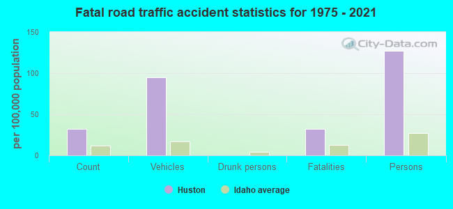
Huston fatal accident list:
FCC Registered Broadcast Land Mobile Towers:
1- 16548 Chicken Dinner Rd (Lat: 43.610722 Lon: -116.771833), Type: Pole, Structure height: 12.2 m, Overall height: 13.2 m, Call Sign: WPYW573, Licensee ID: L00069492,
Assigned Frequencies: 154.463 MHz, Grant Date: 09/18/2013, Expiration Date: 11/17/2023, Cancellation Date: 01/20/2024, Certifier: Scott A Thomas, Registrant: Idaho Power Company, 1221 W Idaho, Boise, ID 83702, Phone: (208) 388-2200, Fax: (208) 388-6906, Email:
FCC Registered Amateur Radio Licenses:
2- Call Sign: WB4YJT, Licensee ID: L00222337, Grant Date: 03/09/2020, Expiration Date: 06/05/2030, Certifier: John H Kernkamp, Registrant: John H Kernkamp, Huston, ID 83630
- Call Sign: KJ7MNQ, Licensee ID: L02326359, Grant Date: 02/18/2020, Expiration Date: 02/18/2030, Certifier: Weston Hawks, Registrant: Weston Hawks, 16021 Pride Lane, Huston, ID 83630-8777
FAA Registered Aircraft:
1- Aircraft: PIPER PA-32-260 (Category: Land, Seats: 6, Weight: Up to 12,499 Pounds, Speed: 126 mph), Engine: LYCOMING O&VO-360 SER (180 HP) (Reciprocating)
N-Number: 3233W, N3233W, N-3233W, Serial Number: 32-45, Year manufactured: 1965, Airworthiness Date: 08/16/1965, Certificate Issue Date: 08/21/2019
Registrant (Co-Owned): Benjamin R Russell, Po Box 236, Huston, ID 83630, Other Owners: Nathan A Pickens
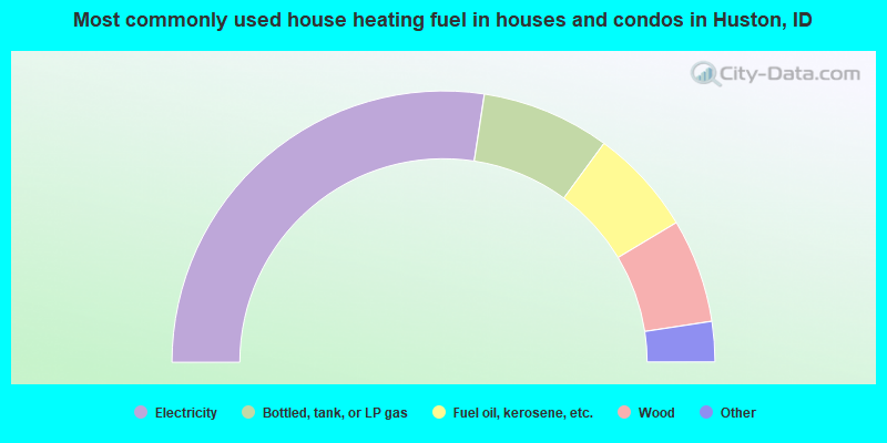
- 54.9%Electricity
- 15.3%Bottled, tank, or LP gas
- 12.7%Fuel oil, kerosene, etc.
- 12.4%Wood
- 3.3%Other fuel
- 1.5%Utility gas
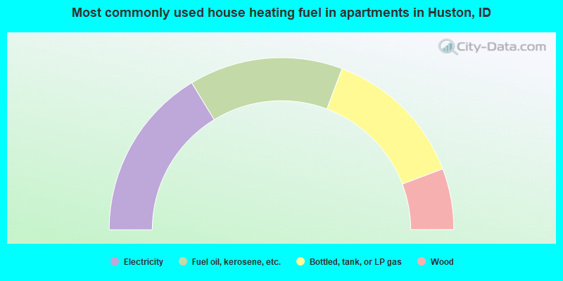
- 32.6%Electricity
- 28.9%Fuel oil, kerosene, etc.
- 27.1%Bottled, tank, or LP gas
- 11.5%Wood
Huston compared to Idaho state average:
- Unemployed percentage below state average.
- Median age significantly below state average.
- Foreign-born population percentage significantly below state average.
- Renting percentage below state average.
- Length of stay since moving in significantly above state average.
- Number of rooms per house significantly below state average.
- House age significantly below state average.
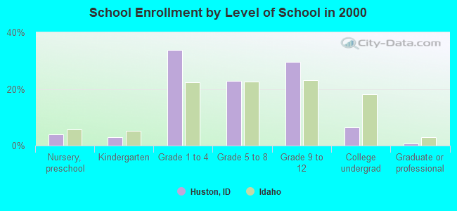
- Number of college students below state average.