Isonville, Kentucky
Submit your own pictures of this place and show them to the world
- OSM Map
- General Map
- Google Map
- MSN Map

| Males: 1,312 | |
| Females: 1,327 |
| Median resident age: | 35.6 years |
| Kentucky median age: | 35.9 years |
Zip code: 41171
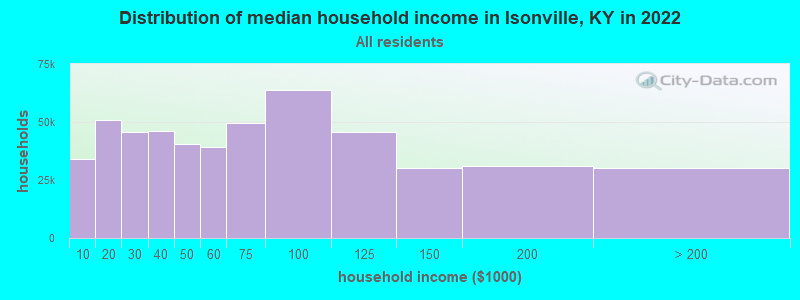
| Isonville: | $34,657 |
| KY: | $59,341 |
Estimated per capita income in 2022: $15,147 (it was $10,456 in 2000)
Isonville CCD income, earnings, and wages data
Estimated median house or condo value in 2022: $91,080 (it was $39,700 in 2000)
| Isonville: | $91,080 |
| KY: | $196,300 |
Mean prices in 2022: all housing units: $153,944; detached houses: $180,483; mobile homes: $93,008
Detailed information about poverty and poor residents in Isonville, KY


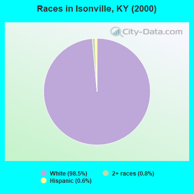
- 2,15898.5%White alone
- 170.8%Two or more races
- 130.6%Hispanic
- 10.05%Black alone
- 10.05%American Indian alone
Races in Isonville detailed stats: ancestries, foreign born residents, place of birth
 Recent articles from our blog. Our writers, many of them Ph.D. graduates or candidates, create easy-to-read articles on a wide variety of topics.
Current Local Time: EST time zone
Elevation: 690 feet
Land area: 104.2 square miles.
Population density: 25 people per square mile (very low).

| Isonville CCD: | 0.7% ($276) |
| Kentucky: | 0.8% ($610) |
Nearest city with pop. 50,000+: Huntington, WV  (37.8 miles , pop. 51,475).
Nearest city with pop. 200,000+: Fayette, KY (80.9 miles , pop. 260,512).
Nearest city with pop. 1,000,000+: Chicago, IL (357.5 miles , pop. 2,896,016).
Nearest cities:
), ), ), ), ), )Latitude: 38.11 N, Longitude: 83.01 W
Area code commonly used in this area: 606

| Here: | 8.2% |
| Kentucky: | 3.8% |
- Construction (18.2%)
- Educational services (15.5%)
- Broadcasting & telecommunications (7.4%)
- Food & beverage stores (5.3%)
- Food (4.2%)
- Social assistance (4.2%)
- Health care (4.1%)
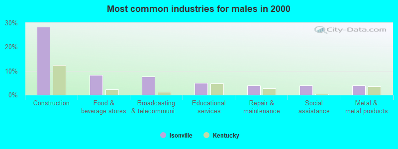
- Construction (28.4%)
- Food & beverage stores (8.3%)
- Broadcasting & telecommunications (7.6%)
- Educational services (4.9%)
- Repair & maintenance (3.9%)
- Social assistance (3.9%)
- Metal & metal products (3.9%)
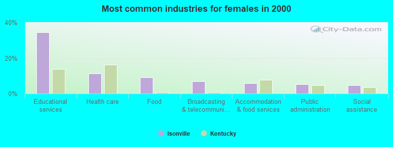
- Educational services (34.5%)
- Health care (11.4%)
- Food (9.2%)
- Broadcasting & telecommunications (7.0%)
- Accommodation & food services (5.7%)
- Public administration (5.2%)
- Social assistance (4.8%)
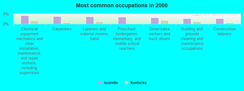
- Electrical equipment mechanics and other installation, maintenance, and repair workers, including supervisors (6.9%)
- Carpenters (6.0%)
- Laborers and material movers, hand (5.8%)
- Preschool, kindergarten, elementary, and middle school teachers (5.6%)
- Driver/sales workers and truck drivers (5.0%)
- Building and grounds cleaning and maintenance occupations (4.4%)
- Construction laborers (4.4%)
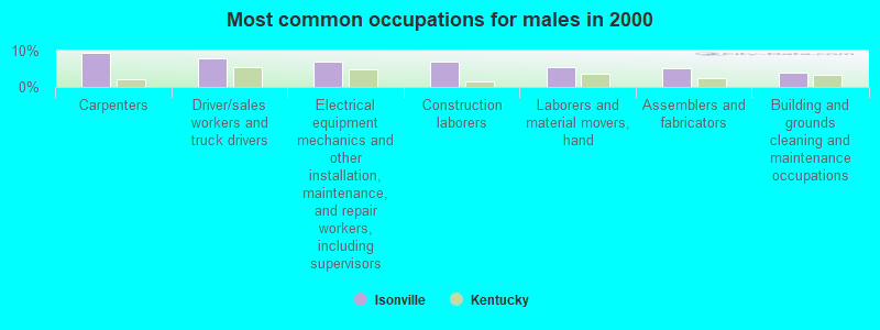
- Carpenters (9.3%)
- Driver/sales workers and truck drivers (7.8%)
- Electrical equipment mechanics and other installation, maintenance, and repair workers, including supervisors (6.8%)
- Construction laborers (6.8%)
- Laborers and material movers, hand (5.4%)
- Assemblers and fabricators (5.1%)
- Building and grounds cleaning and maintenance occupations (3.9%)
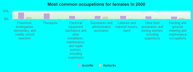
- Preschool, kindergarten, elementary, and middle school teachers (13.5%)
- Therapists (11.8%)
- Electrical equipment mechanics and other installation, maintenance, and repair workers, including supervisors (7.0%)
- Secretaries and administrative assistants (6.6%)
- Laborers and material movers, hand (6.6%)
- Other food preparation and serving workers, including supervisors (5.7%)
- Building and grounds cleaning and maintenance occupations (5.2%)
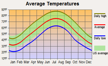
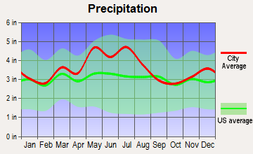
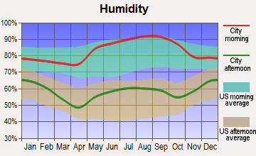
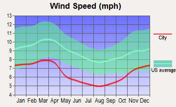
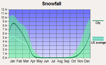
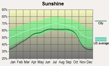
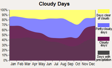
Average climate in Isonville, Kentucky
Based on data reported by over 4,000 weather stations
(lower is better)
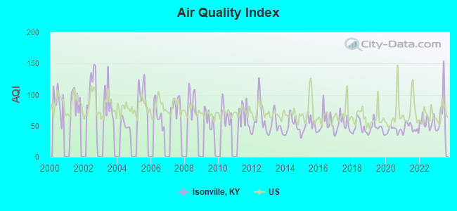
Air Quality Index (AQI) level in 2023 was 69.8. This is about average.
| City: | 69.8 |
| U.S.: | 72.6 |
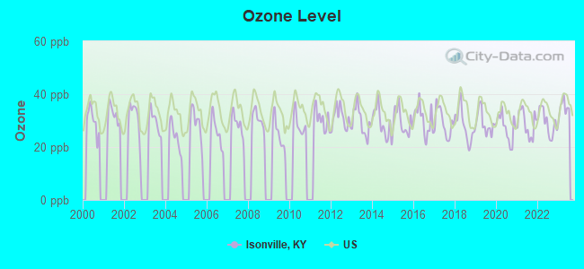
Ozone [ppb] level in 2023 was 34.8. This is about average. Closest monitor was 9.1 miles away from the city center.
| City: | 34.8 |
| U.S.: | 33.3 |
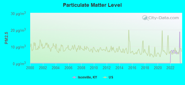
Particulate Matter (PM2.5) [µg/m3] level in 2022 was 6.85. This is about average. Closest monitor was 9.1 miles away from the city center.
| City: | 6.85 |
| U.S.: | 8.11 |
Tornado activity:
Isonville-area historical tornado activity is significantly below Kentucky state average. It is 51% smaller than the overall U.S. average.
On 4/23/1968, a category F5 (max. wind speeds 261-318 mph) tornado 42.5 miles away from the Isonville place center killed 7 people and injured 93 people and caused between $500,000 and $5,000,000 in damages.
On 4/8/1965, a category F3 (max. wind speeds 158-206 mph) tornado 26.7 miles away from the place center injured 3 people and caused between $50,000 and $500,000 in damages.
Earthquake activity:
Isonville-area historical earthquake activity is significantly above Kentucky state average. It is 27% greater than the overall U.S. average.On 7/27/1980 at 18:52:21, a magnitude 5.2 (5.1 MB, 4.7 MS, 5.0 UK, 5.2 UK, Class: Moderate, Intensity: VI - VII) earthquake occurred 51.1 miles away from the city center
On 8/23/2011 at 17:51:04, a magnitude 5.8 (5.8 MW, Depth: 3.7 mi) earthquake occurred 276.9 miles away from Isonville center
On 9/7/1988 at 02:28:09, a magnitude 4.6 (4.5 MB, 4.6 LG, Class: Light, Intensity: IV - V) earthquake occurred 47.2 miles away from the city center
On 8/9/2020 at 12:07:37, a magnitude 5.1 (5.1 MW, Depth: 4.7 mi) earthquake occurred 154.6 miles away from the city center
On 4/18/2008 at 09:36:59, a magnitude 5.4 (5.1 MB, 4.8 MS, 5.4 MW, 5.2 MW) earthquake occurred 265.7 miles away from Isonville center
On 11/2/2006 at 17:53:02, a magnitude 4.3 (4.3 MB, Depth: 0.6 mi) earthquake occurred 86.7 miles away from Isonville center
Magnitude types: regional Lg-wave magnitude (LG), body-wave magnitude (MB), surface-wave magnitude (MS), moment magnitude (MW)
Natural disasters:
The number of natural disasters in Elliott County (24) is greater than the US average (15).Major Disasters (Presidential) Declared: 19
Emergencies Declared: 3
Causes of natural disasters: Floods: 15, Storms: 15, Tornadoes: 8, Mudslides: 7, Winter Storms: 6, Landslides: 4, Winds: 2, Blizzard: 1, Freeze: 1, Hurricane: 1, Snow: 1, Snowfall: 1, Snowstorm: 1, Other: 1 (Note: some incidents may be assigned to more than one category).
Colleges/universities with over 2000 students nearest to Isonville:
- Morehead State University (about 24 miles; Morehead, KY; Full-time enrollment: 7,523)
- Ashland Community and Technical College (about 32 miles; Ashland, KY; FT enrollment: 2,482)
- Big Sandy Community and Technical College (about 32 miles; Prestonsburg, KY; FT enrollment: 2,660)
- Marshall University (about 39 miles; Huntington, WV; FT enrollment: 11,450)
- Shawnee State University (about 44 miles; Portsmouth, OH; FT enrollment: 4,160)
- Maysville Community and Technical College (about 57 miles; Maysville, KY; FT enrollment: 2,969)
- Hazard Community and Technical College (about 62 miles; Hazard, KY; FT enrollment: 2,087)
Public elementary/middle school in Isonville:
- ISONVILLE ELEMENTARY SCHOOL (Students: 138, Location: 5980 SOUTH KY 32, Grades: KG-6)
Points of interest:
Notable locations in Isonville: Little Fork (A), Isonville Volunteer Fire Department (B). Display/hide their locations on the map
Churches in Isonville include: Fraley Chapel (A), Little Fork Church (B), Lower Bruin Church (C), Watson Church (D), Lower Blaine Trace Enterprise Baptist Church (E), Wallow Hole Church (F). Display/hide their locations on the map
Cemeteries: Backbone Cemetery (1), Burton Cemetery (2), Arthur Bays Cemetery (3), Burton Cemetery (4), Gilliam Cemetery (5), McDavid Cemetery (6), Oney Cemetery (7). Display/hide their locations on the map
Streams, rivers, and creeks: Anderson Branch (A), Beech Branch (B), Bentley Branch (C), Big Fork (D), Bill Branch (E), Bills Branch (F), Birchfield Creek (G), Blaine Trace (H), Boggs Branch (I). Display/hide their locations on the map
Park in Isonville: Grayson Lake Wildlife Management Area (1). Display/hide its location on the map
| This place: | 2.6 people |
| Kentucky: | 2.5 people |
| This place: | 75.7% |
| Whole state: | 66.9% |
| This place: | 3.8% |
| Whole state: | 6.4% |
Likely homosexual households (counted as self-reported same-sex unmarried-partner households)
- Lesbian couples: 0.1% of all households
- Gay men: 0.0% of all households
| This place: | 31.5% |
| Whole state: | 15.8% |
| This place: | 9.1% |
| Whole state: | 6.6% |
For population 15 years and over in Isonville:
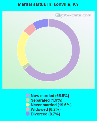
- Never married: 19.6%
- Now married: 65.5%
- Separated: 1.9%
- Widowed: 6.2%
- Divorced: 8.7%
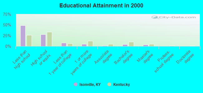
For population 25 years and over in Isonville:
- High school or higher: 50.9%
- Bachelor's degree or higher: 8.4%
- Graduate or professional degree: 4.0%
- Unemployed: 10.6%
- Mean travel time to work (commute): 47.3 minutes
| Here: | 17.9 |
| Kentucky average: | 13.8 |
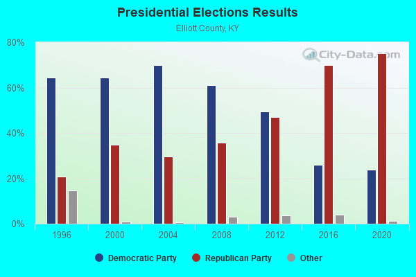
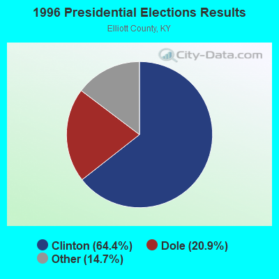
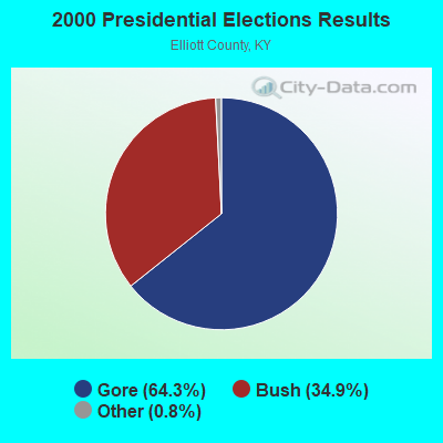
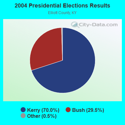
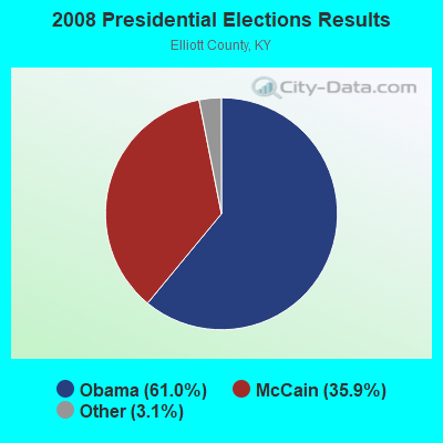
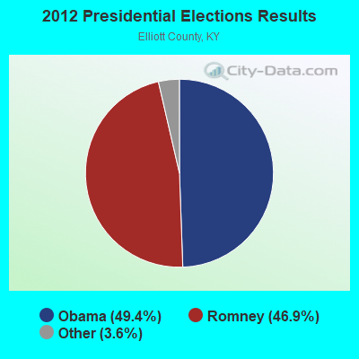
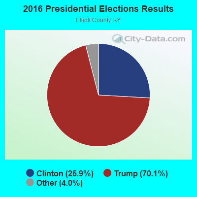
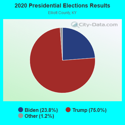
Graphs represent county-level data. Detailed 2008 Election Results
Religion statistics for Isonville, KY (based on Elliott County data)
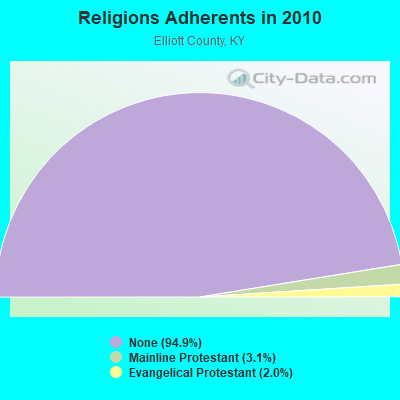
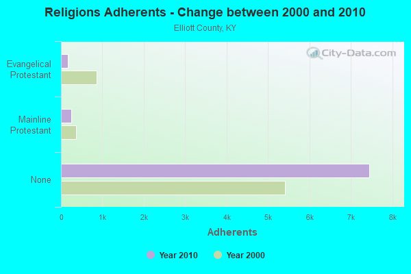
| Religion | Adherents | Congregations |
|---|---|---|
| Mainline Protestant | 245 | 1 |
| Evangelical Protestant | 158 | 7 |
| None | 7,449 | - |
Food Environment Statistics:
| Elliott County: | 1.40 / 10,000 pop. |
| State: | 2.19 / 10,000 pop. |
| Here: | 2.80 / 10,000 pop. |
| Kentucky: | 4.36 / 10,000 pop. |
| Elliott County: | 1.40 / 10,000 pop. |
| Kentucky: | 5.74 / 10,000 pop. |
| Elliott County: | 11.5% |
| Kentucky: | 11.0% |
| Elliott County: | 31.6% |
| Kentucky: | 30.0% |
| Elliott County: | 15.6% |
| Kentucky: | 15.9% |
Strongest AM radio stations in Isonville:
- WGOH (1370 AM; 5 kW; GRAYSON, KY; Owner: CARTER COUNTY BROADCASTING CO., INC.)
- WKYH (600 AM; 5 kW; PAINTSVILLE, KY; Owner: HIGHLANDS BROADCASTING CORPORATION)
- WTVN (610 AM; 50 kW; COLUMBUS, OH; Owner: CITICASTERS LICENSES, L.P.)
- WLW (700 AM; 50 kW; CINCINNATI, OH; Owner: JACOR BROADCASTING CORPORATION)
- WVHU (800 AM; 5 kW; HUNTINGTON, WV; Owner: CAPSTAR TX LIMITED PARTNERSHIP)
- WPRT (960 AM; 5 kW; PRESTONSBURG, KY; Owner: EAST KENTUCKY RADIO NETWORK, INC.)
- WRVC (930 AM; 5 kW; HUNTINGTON, WV; Owner: FIFTH AVENUE BROADCASTING COMPANY, INC.)
- WTCR (1420 AM; 5 kW; KENOVA, WV; Owner: CAPSTAR TX LIMITED PARTNERSHIP)
- WDOC (1310 AM; 5 kW; PRESTONSBURG, KY)
- WMTC (730 AM; 5 kW; VANCLEVE, KY; Owner: THE KENTUCKY MOUNTAIN HOLINESS ASSN.)
- WOKT (1040 AM; daytime; 2 kW; CANNONSBURG, KY; Owner: BIG RIVER RADIO, INC.-KY)
- WHAS (840 AM; 50 kW; LOUISVILLE, KY; Owner: CLEAR CHANNEL BROADCASTING LICENSES, INC.)
- WEKG (810 AM; daytime; 5 kW; JACKSON, KY; Owner: INTERMOUNTAIN B/CING CO., INC.)
Strongest FM radio stations in Isonville:
- WMKY (90.3 FM; MOREHEAD, KY; Owner: MOREHEAD STATE UNIVERSITY)
- WKLW-FM (94.7 FM; PAINTSVILLE, KY; Owner: B & G BROADCASTING, INC.)
- WPAY-FM (104.1 FM; PORTSMOUTH, OH; Owner: RADIO STATIONS WPAY/WPFB, INC.)
- WQHY (95.5 FM; PRESTONSBURG, KY; Owner: WDOC, INC.)
- WUGO (102.3 FM; GRAYSON, KY; Owner: CARTER COUNTY BROADCASTING CO., INC.)
- WDGG (93.7 FM; ASHLAND, KY; Owner: FIFTH AVENUE B/CASTING COMPANY, INC.)
- WBMK (88.5 FM; MOREHEAD, KY; Owner: AMERICAN FAMILY ASSOCIATION)
- WSIP-FM (98.9 FM; PAINTSVILLE, KY; Owner: SIP BROADCASTING, INC.)
- WOSP (91.5 FM; PORTSMOUTH, OH; Owner: THE OHIO STATE UNIVERSITY)
- WLKS-FM (102.9 FM; WEST LIBERTY, KY; Owner: MORGAN COUNTY INDUSTRIES, INC.)
- WBKS (107.1 FM; IRONTON, OH; Owner: CAPSTAR TX LIMITED PARTNERSHIP)
- WZAQ (92.3 FM; LOUISA, KY; Owner: LOUISA COMMUNICATIONS, INC.)
- WRLV-FM (106.5 FM; SALYERSVILLE, KY; Owner: WALLINGFORD BROADCASTING COMPANY, INC.)
- WQXX (106.1 FM; MOREHEAD, KY; Owner: MORGAN COUNTY INDUSTRIES, INC.)
- WIVY (96.3 FM; MOREHEAD, KY; Owner: GATEWAY RADIO WORKS, INC.)
TV broadcast stations around Isonville:
- WUPX-TV (Channel 67; MOREHEAD, KY; Owner: PAXSON LEXINGTON LICENSE, INC.)
- WKMR (Channel 38; MOREHEAD, KY; Owner: KENTUCKY AUTHORITY FOR EDUCATIONAL TV)
- W26BK (Channel 26; TALBERT, KY; Owner: MS COMMUNICATIONS, LLC)
- WPBY-TV (Channel 33; HUNTINGTON, WV; Owner: WEST VIRGINIA EDUCATIONAL BROADCASTING AUTHORITY)
- W16BI (Channel 16; TALBERT, KY; Owner: MS COMMUNICATIONS, LLC)
FCC Registered Antenna Towers:
4- W.A. Gillum, North Of Highway 32 Near Isonville, Elliott County, Kentucky (Lat: 38.069556 Lon: -83.076583), Type: 57.9, Structure height: 21063 m, Overall height: 54.8 m, Licensee ID: L, Registrant: East Kentucky Network, LLC D/B/A Appalachian Wireless, Compliance@ekn.Com, , Ivel, Phone: (606) 477-2355
- W.A. Gillum, North Of Highway 32 Near Isonville, Elliott County, Kentucky (Lat: 38.069556 Lon: -83.076583), Type: 57.9, Structure height: 21063 m, Overall height: 54.8 m, Registrant: East Kentucky Network, LLC D/B/A Appalachian Wireless, Compliance@ekn.Com, , Ivel, Phone: (606) 477-2355
- W.A. Gillum, North Of Highway 32 Near Isonville, Elliott County, Kentucky (Lat: 38.069556 Lon: -83.076583), Type: 57.9, Structure height: 21063 m, Overall height: 54.8 m, Registrant: East Kentucky Network, LLC D/B/A Appalachian Wireless, Compliance@ekn.Com, , Ivel, Phone: (606) 477-2355
- Michael L Johnson, North Of Highway 32 Near Isonville, Elliott County, Kentucky (Lat: 38.069556 Lon: -83.076583), Type: 57.9, Structure height: 21063 m, Overall height: 54.8 m, Registrant: East Kentucky Network, LLC D/B/A Appalachian Wireless, Compliance@ekn.Com, , Ivel, Phone: (606) 477-2355
FCC Registered Amateur Radio Licenses:
2- Call Sign: KO4CJM, Licensee ID: L02331166, Grant Date: 03/05/2020, Expiration Date: 03/05/2030, Certifier: Tina Preece, Registrant: Tina Preece, 9079 S Ky 32, Isonville, KY 41149
- Call Sign: KO4CJN, Licensee ID: L02331167, Grant Date: 03/05/2020, Expiration Date: 03/05/2030, Certifier: William C Reed, Registrant: William C Reed, 2695 S Ky 706, Isonville, KY 41149
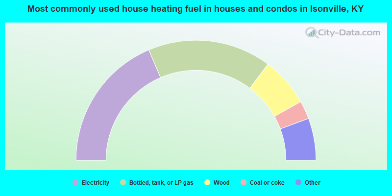
- 37.1%Electricity
- 33.3%Bottled, tank, or LP gas
- 13.3%Wood
- 4.9%Coal or coke
- 3.6%Fuel oil, kerosene, etc.
- 3.6%Other fuel
- 3.3%Utility gas
- 0.7%No fuel used
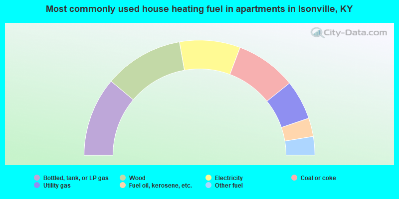
- 22.2%Bottled, tank, or LP gas
- 22.2%Wood
- 17.0%Electricity
- 17.0%Coal or coke
- 11.1%Utility gas
- 5.2%Fuel oil, kerosene, etc.
- 5.2%Other fuel
Isonville compared to Kentucky state average:
- Median household income below state average.
- Median house value below state average.
- Black race population percentage significantly below state average.
- Hispanic race population percentage significantly below state average.
- Median age below state average.
- Foreign-born population percentage significantly below state average.
- Renting percentage below state average.
- Length of stay since moving in significantly above state average.
- Number of rooms per house significantly below state average.
- House age significantly below state average.
- Number of college students below state average.
- Percentage of population with a bachelor's degree or higher significantly below state average.