Landgrove, Vermont
Submit your own pictures of this town and show them to the world
- OSM Map
- Google Map
- MSN Map
Population change since 2000: +9.7%
 |
| Males: 73 | |
| Females: 85 |
| Median resident age: | 53.5 years |
| Vermont median age: | 45.8 years |
Zip code: 05152
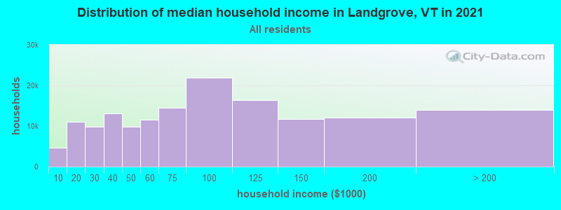
| Landgrove: | $66,518 |
| VT: | $73,991 |
Estimated per capita income in 2022: $66,356 (it was $34,929 in 2000)
Estimated median house or condo value in 2022: $774,178 (it was $322,700 in 2000)
| Landgrove: | $774,178 |
| VT: | $304,700 |
Mean prices in 2022: all housing units: $328,619; detached houses: $344,818; townhouses or other attached units: $277,995; in 2-unit structures: $228,670; in 3-to-4-unit structures: $413,467; in 5-or-more-unit structures: $239,659; mobile homes: $88,728
Detailed information about poverty and poor residents in Landgrove, VT


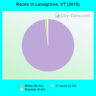
- 15598.1%White alone
- 21.3%Two or more races
- 10.6%Hispanic
 Recent articles from our blog. Our writers, many of them Ph.D. graduates or candidates, create easy-to-read articles on a wide variety of topics.
Ancestries: English (18.8%), German (12.5%), Irish (11.1%), Scottish (10.4%), French (7.6%), Norwegian (4.9%).
Current Local Time: EST time zone
Land area: 9.12 square miles.
Population density: 17 people per square mile (very low).
3 residents are foreign born (2.1% Europe).
| This town: | 2.1% |
| Vermont: | 3.8% |
| Landgrove town: | 1.0% ($3,125) |
| Vermont: | 2.0% ($2,196) |
Nearest city with pop. 50,000+: Albany, NY  (62.7 miles , pop. 95,658).
Nearest city with pop. 200,000+: Boston, MA (110.8 miles , pop. 589,141).
Nearest city with pop. 1,000,000+: Bronx, NY (175.1 miles , pop. 1,332,650).
Nearest cities:
), ), ), ), ), Latitude: 43.26 N, Longitude: 72.85 W
Area code commonly used in this area: 802
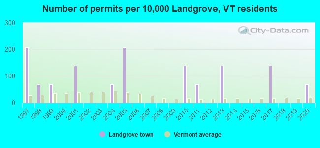
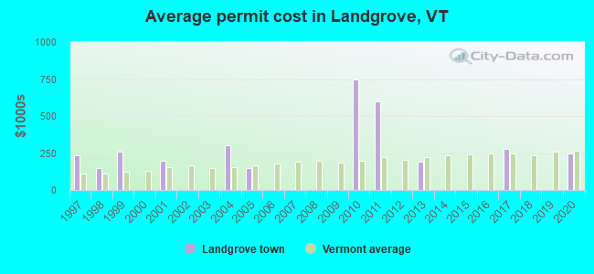
Single-family new house construction building permits:
- 2020: 1 building, cost: $248,200
- 2017: 2 buildings, average cost: $275,000
- 2013: 2 buildings, average cost: $193,300
- 2011: 1 building, cost: $600,000
- 2010: 2 buildings, average cost: $750,000
- 2005: 3 buildings, average cost: $150,200
- 2004: 1 building, cost: $300,000
- 2001: 2 buildings, average cost: $200,000
- 1999: 1 building, cost: $260,000
- 1998: 1 building, cost: $150,000
- 1997: 3 buildings, average cost: $233,300
| Here: | 1.1% |
| Vermont: | 2.0% |
Average climate in Landgrove, Vermont
Based on data reported by over 4,000 weather stations


(lower is better)
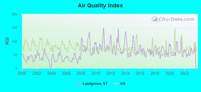
Air Quality Index (AQI) level in 2022 was 56.9. This is better than average.
| City: | 56.9 |
| U.S.: | 72.6 |
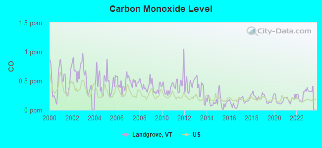
Carbon Monoxide (CO) [ppm] level in 2022 was 0.251. This is about average. Closest monitor was 24.7 miles away from the city center.
| City: | 0.251 |
| U.S.: | 0.251 |
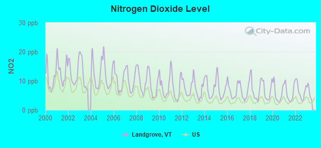
Nitrogen Dioxide (NO2) [ppb] level in 2022 was 6.51. This is worse than average. Closest monitor was 24.7 miles away from the city center.
| City: | 6.51 |
| U.S.: | 5.11 |
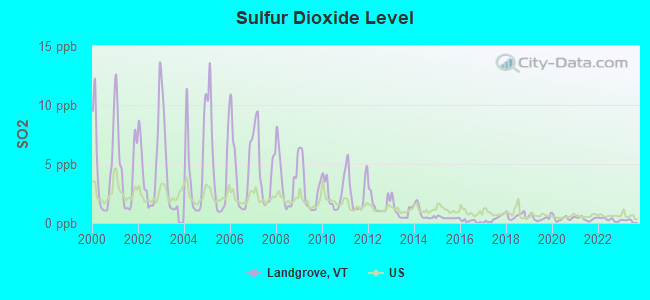
Sulfur Dioxide (SO2) [ppb] level in 2022 was 0.299. This is significantly better than average. Closest monitor was 15.8 miles away from the city center.
| City: | 0.299 |
| U.S.: | 1.515 |
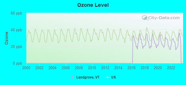
Ozone [ppb] level in 2022 was 23.5. This is significantly better than average. Closest monitor was 24.7 miles away from the city center.
| City: | 23.5 |
| U.S.: | 33.3 |
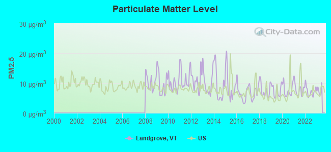
Particulate Matter (PM2.5) [µg/m3] level in 2022 was 7.23. This is about average. Closest monitor was 24.7 miles away from the city center.
| City: | 7.23 |
| U.S.: | 8.11 |
Tornado activity:
Landgrove-area historical tornado activity is above Vermont state average. It is 51% smaller than the overall U.S. average.
On 8/20/1968, a category F3 (max. wind speeds 158-206 mph) tornado 11.6 miles away from the Landgrove town center injured one person and caused between $5000 and $50,000 in damages.
On 5/31/1998, a category F3 tornado 28.3 miles away from the town center injured 68 people and caused $71 million in damages.
Earthquake activity:
Landgrove-area historical earthquake activity is significantly above Vermont state average. It is 69% smaller than the overall U.S. average.On 10/7/1983 at 10:18:46, a magnitude 5.3 (5.1 MB, 5.3 LG, 5.1 ML, Class: Moderate, Intensity: VI - VII) earthquake occurred 88.5 miles away from the city center
On 4/20/2002 at 10:50:47, a magnitude 5.3 (5.3 ML, Depth: 3.0 mi) earthquake occurred 96.1 miles away from Landgrove center
On 4/20/2002 at 10:50:47, a magnitude 5.2 (5.2 MB, 4.2 MS, 5.2 MW, 5.0 MW) earthquake occurred 95.0 miles away from Landgrove center
On 1/19/1982 at 00:14:42, a magnitude 4.7 (4.5 MB, 4.7 MD, 4.5 LG, Class: Light, Intensity: IV - V) earthquake occurred 65.2 miles away from the city center
On 10/16/2012 at 23:12:25, a magnitude 4.7 (4.7 ML, Depth: 10.0 mi) earthquake occurred 112.9 miles away from the city center
On 6/17/1991 at 08:53:16, a magnitude 4.1 (4.0 MB, 4.0 LG, Depth: 3.1 mi) earthquake occurred 102.1 miles away from Landgrove center
Magnitude types: regional Lg-wave magnitude (LG), body-wave magnitude (MB), duration magnitude (MD), local magnitude (ML), surface-wave magnitude (MS), moment magnitude (MW)
Natural disasters:
The number of natural disasters in Bennington County (15) is near the US average (15).Major Disasters (Presidential) Declared: 10
Emergencies Declared: 2
Causes of natural disasters: Floods: 8, Storms: 8, Tropical Storms: 2, Winter Storms: 2, Hurricane: 1, Landslide: 1, Snowstorm: 1, Wind: 1, Other: 1 (Note: some incidents may be assigned to more than one category).
Colleges/universities with over 2000 students nearest to Landgrove:
- Castleton State College (about 29 miles; Castleton, VT; Full-time enrollment: 2,079)
- Keene State College (about 38 miles; Keene, NH; FT enrollment: 5,098)
- Adirondack Community College (about 41 miles; Queensbury, NY; FT enrollment: 2,826)
- Dartmouth College (about 42 miles; Hanover, NH; FT enrollment: 6,030)
- Williams College (about 43 miles; Williamstown, MA; FT enrollment: 2,141)
- Skidmore College (about 49 miles; Saratoga Springs, NY; FT enrollment: 2,753)
- SUNY Empire State College (about 49 miles; Saratoga Springs, NY; FT enrollment: 9,473)
Points of interest:
Notable locations in Landgrove: Nordio Cross Country Ski Area (A), Villiage Inn Winter Sports Area (B). Display/hide their locations on the map
Cemeteries: Old Cemetery (1), New Cemetery (2). Display/hide their locations on the map
Streams, rivers, and creeks: Jones Brook (A). Display/hide its location on the map
Drinking water stations with addresses in Landgrove and their reported violations in the past:
LANDGROVE INN (Address: 132 LANDGROVE RD , Population served: 87, Groundwater):Past monitoring violations:
- 14 routine major monitoring violations
- 4 regular monitoring violations
| This town: | 2.1 people |
| Vermont: | 2.3 people |
| This town: | 64.9% |
| Whole state: | 62.5% |
| This town: | 4.1% |
| Whole state: | 9.2% |
Likely homosexual households (counted as self-reported same-sex unmarried-partner households)
- Lesbian couples: 0.0% of all households
- Gay men: 1.4% of all households
| This town: | 15.7% |
| Whole state: | 9.4% |
| This town: | 3.9% |
| Whole state: | 3.6% |
For population 15 years and over in Landgrove:

- Never married: 10.3%
- Now married: 59.8%
- Separated: 0.0%
- Widowed: 9.2%
- Divorced: 20.7%
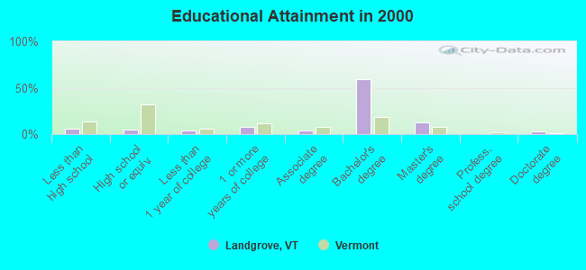
For population 25 years and over in Landgrove:
- High school or higher: 93.8%
- Bachelor's degree or higher: 74.1%
- Graduate or professional degree: 14.8%
- Unemployed: 4.0%
- Mean travel time to work (commute): 24.3 minutes
| Here: | 8.2 |
| Vermont average: | 11.7 |
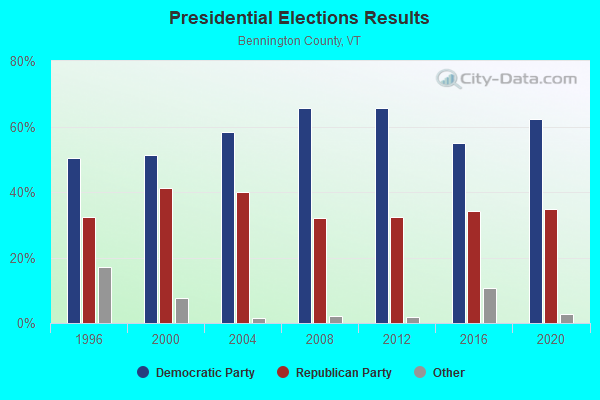
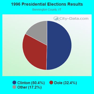
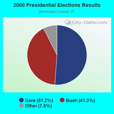
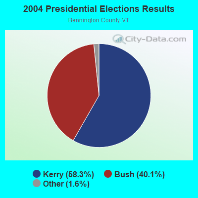
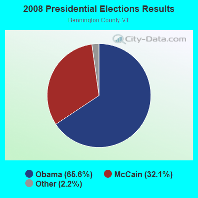
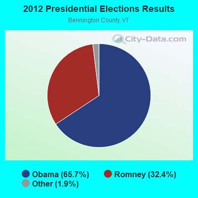
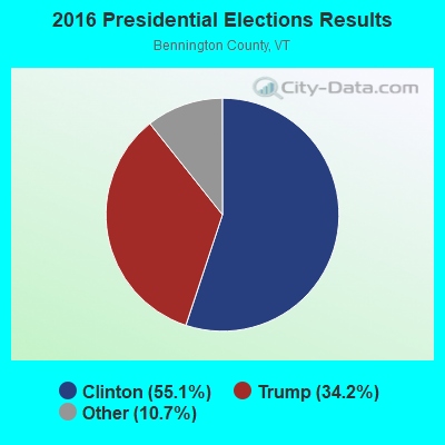
Graphs represent county-level data. Detailed 2008 Election Results
Religion statistics for Landgrove, VT (based on Bennington County data)

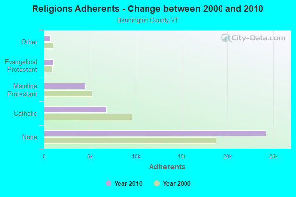
| Religion | Adherents | Congregations |
|---|---|---|
| Catholic | 6,742 | 8 |
| Mainline Protestant | 4,490 | 26 |
| Evangelical Protestant | 1,005 | 12 |
| Other | 693 | 5 |
| None | 24,195 | - |
Food Environment Statistics:
| Here: | 3.85 / 10,000 pop. |
| Vermont: | 3.84 / 10,000 pop. |
| Bennington County: | 3.30 / 10,000 pop. |
| Vermont: | 1.95 / 10,000 pop. |
| Bennington County: | 5.77 / 10,000 pop. |
| Vermont: | 6.40 / 10,000 pop. |
| This county: | 16.48 / 10,000 pop. |
| State: | 11.52 / 10,000 pop. |
| Bennington County: | 8.4% |
| Vermont: | 6.8% |
| Bennington County: | 22.9% |
| Vermont: | 22.3% |
| Bennington County: | 11.6% |
| State: | 13.3% |
Strongest AM radio stations in Landgrove:
- WGY (810 AM; 50 kW; SCHENECTADY, NY; Owner: CLEAR CHANNEL BROADCASTING LICENSES, INC.)
- WNNZ (640 AM; 50 kW; WESTFIELD, MA; Owner: CLEAR CHANNEL BROADCASTING LICENSES, INC.)
- WNBX (1480 AM; 5 kW; SPRINGFIELD, VT)
- WPTR (1540 AM; 50 kW; ALBANY, NY; Owner: KIMTRON, INC.)
- WCRN (830 AM; 50 kW; WORCESTER, MA; Owner: CARTER BROADCASTING CORPORATION)
- WNTK (1020 AM; 10 kW; NEWPORT, NH; Owner: KOOR COMMUNICATIONS, INC.)
- WRKO (680 AM; 50 kW; BOSTON, MA; Owner: ENTERCOM BOSTON LICENSE, LLC)
- WSYB (1380 AM; 5 kW; RUTLAND, VT; Owner: CAPSTAR TX LIMITED PARTNERSHIP)
- WEEI (850 AM; 50 kW; BOSTON, MA; Owner: ENTERCOM BOSTON LICENSE, LLC)
- WVNE (760 AM; daytime; 25 kW; LEICESTER, MA; Owner: BLOUNT MASSCOM, INC.)
- WTIC (1080 AM; 50 kW; HARTFORD, CT; Owner: INFINITY RADIO OPERATIONS INC.)
- WKOX (1200 AM; 50 kW; FRAMINGHAM, MA; Owner: CAPSTAR TX LIMITED PARTNERSHIP)
- WALE (990 AM; 50 kW; GREENVILLE, RI; Owner: NORTH AMERICAN BROADCASTING CO., INC.)
Strongest FM radio stations in Landgrove:
- WEQX (102.7 FM; MANCHESTER, VT; Owner: NORTHSHIRE COMMUNICATIONS, INC.)
- WJAN (95.1 FM; SUNDERLAND, VT; Owner: 6 JOHNSON ROAD LICENSES, INC.)
- WJJR (98.1 FM; RUTLAND, VT; Owner: 6 JOHNSON ROAD LICENSES, INC.)
- WZRT (97.1 FM; RUTLAND, VT; Owner: CAPSTAR TX LIMITED PARTNERSHIP)
- WEBK (105.3 FM; KILLINGTON, VT; Owner: 6 JOHNSON ROAD LICENSES, INC.)
- WVPR (89.5 FM; WINDSOR, VT; Owner: VERMONT PUBLIC RADIO)
- WGLV (91.7 FM; WOODSTOCK, VT; Owner: CHRISTIAN MINISTRIES INC)
- WHDQ-FM1 (106.1 FM; RUTLAND, VT; Owner: GREAT NORTHERN RADIO, L.L.C.)
- WVAY (100.7 FM; WILMINGTON, VT; Owner: GREAT NORTHERN RADIO, L.L.C.)
- WHDQ (106.1 FM; CLAREMONT, NH; Owner: GREAT NORTHERN RADIO, L.L.C.)
- WNGN (91.9 FM; ARGYLE, NY; Owner: NORTHEAST GOSPEL BROADCASTING INC)
- WVRR (101.7 FM; NEWPORT, NH; Owner: CAPSTAR TX LIMITED PARTNERSHIP)
- WAMC-FM (90.3 FM; ALBANY, NY; Owner: WAMC)
- WCMK (91.9 FM; PUTNEY, VT; Owner: CHRISTIAN MINISTRIES INC)
- WJEN (94.5 FM; RUTLAND, VT; Owner: 6 JOHNSON ROAD LICENSES, INC.)
- WCFR-FM (96.3 FM; WALPOLE, NH; Owner: GREAT NORTHERN RADIO, LLC)
- WKNE (103.7 FM; KEENE, NH; Owner: SAGA COMMUNICATIONS OF NEW ENGLAND, LLC)
- WEVN (90.7 FM; KEENE, NH; Owner: NEW HAMPSHIRE PUBLIC RADIO, INC.)
- WEXP (101.5 FM; BRANDON, VT; Owner: VOX VERMONT, L.L.C.)
- WDEV-FM (96.1 FM; WARREN, VT; Owner: RADIO VERMONT, INC.)
TV broadcast stations around Landgrove:
- WVTA (Channel 41; WINDSOR, VT; Owner: VERMONT ETV, INC.)
- WEKW-TV (Channel 52; KEENE, NH; Owner: UNIVERSITY OF NEW HAMPSHIRE)
Landgrove fatal accident list:
Jul 6, 1982 10:45 PM, Vt11, Vehicles: 1, Persons: 2, Fatalities: 1, Drunk persons involved: 1
- National Bridge Inventory (NBI) Statistics
- 4Number of bridges
- 30ft / 8.8mTotal length
- $1,274,000Total costs
- 5,040Total average daily traffic
- 413Total average daily truck traffic
- 5,292Total future (year 2027) average daily traffic
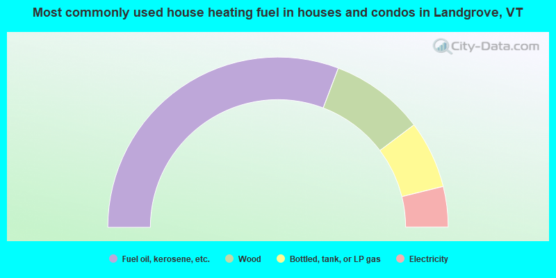
- 61.5%Fuel oil, kerosene, etc.
- 17.9%Wood
- 12.8%Bottled, tank, or LP gas
- 7.7%Electricity
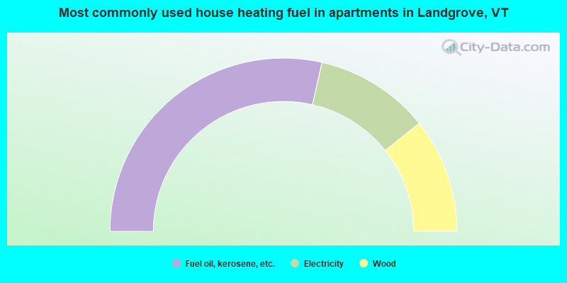
- 57.1%Fuel oil, kerosene, etc.
- 21.4%Electricity
- 21.4%Wood
Landgrove compared to Vermont state average:
- Median house value significantly above state average.
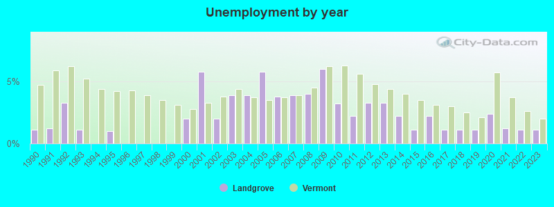
- Unemployed percentage significantly below state average.
- Black race population percentage significantly below state average.
- Hispanic race population percentage significantly below state average.
- Median age above state average.
- Foreign-born population percentage below state average.
- Length of stay since moving in significantly above state average.
- Number of rooms per house significantly below state average.
- House age significantly below state average.
- Number of college students significantly below state average.
- Percentage of population with a bachelor's degree or higher significantly above state average.