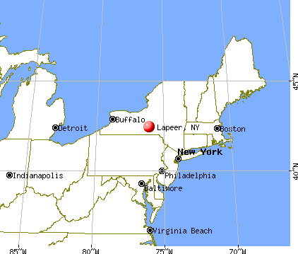
Lapeer, New York
Submit your own pictures of this town and show them to the world
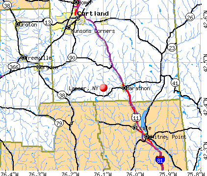
- OSM Map
- General Map
- Google Map
- MSN Map
Population change since 2000: +11.8%
 |
| Males: 384 | |
| Females: 383 |
| Median resident age: | 40.5 years |
| New York median age: | 40.7 years |
Zip codes: 13803.
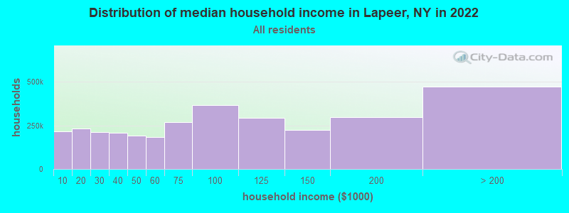
| Lapeer: | $65,207 |
| NY: | $79,557 |
Estimated per capita income in 2022: $29,586 (it was $15,484 in 2000)
Lapeer town income, earnings, and wages data
Estimated median house or condo value in 2022: $148,192 (it was $70,600 in 2000)
| Lapeer: | $148,192 |
| NY: | $400,400 |
Mean prices in 2022: all housing units: $188,917; detached houses: $187,917; townhouses or other attached units: $146,406; in 2-unit structures: $635,934; in 3-to-4-unit structures: $122,178; in 5-or-more-unit structures: $371,569; mobile homes: $103,239
Detailed information about poverty and poor residents in Lapeer, NY
Compare current foreclosures near Lapeer, NY:
| Photo | Address | Area | Beds / Baths | Price | Details |
|---|---|---|---|---|---|

|
#1
Brown Ave
Cortland, NY 13045
|
1,972 sq. feet
|
1 baths 4 beds |
$86,000
|
show details |

|
#2
Pine Hill Rd
Marathon, NY 13803
|
- sq. feet
|
2 baths 3 beds |
$221,660
|
show details |

|
#3
Ny Route 26
Whitney Point, NY 13862
|
2,612 sq. feet
|
2 baths 4 beds |
$49,900
|
show details |

|
#4
Hickory St
Whitney Point, NY 13862
|
1,342 sq. feet
|
1 baths 4 beds |
show details | |

|
#5
Champlin Rd
Groton, NY 13073
|
1,756 sq. feet
|
2 baths 3 beds |
show details | |

|
#6
Tompkins St
Cortland, NY 13045
|
2,358 sq. feet
|
2 baths 5 beds |
show details | |

|
#7
Franklin St
Cortland, NY 13045
|
764 sq. feet
|
1 baths 2 beds |
show details | |

|
#8
State Route 41
Willet, NY 13863
|
2,040 sq. feet
|
1 baths 4 beds |
show details | |

|
#9
Port Watson St
Cortland, NY 13045
|
2,180 sq. feet
|
2 baths 4 beds |
show details | |

|
#10
Route 206
Whitney Point, NY 13862
|
1,812 sq. feet
|
1 baths 4 beds |
show details |
| Photo | Address | Area | Beds / Baths | Price | Details |
|---|---|---|---|---|---|

|
#11
Squires St
Cortland, NY 13045
|
1,424 sq. feet
|
2 baths 2 beds |
show details | |

|
#12
Randall St
Cortland, NY 13045
|
1,484 sq. feet
|
2 baths 3 beds |
show details | |

|
#13
Mclean Rd
Cortland, NY 13045
|
1,259 sq. feet
|
1 baths 3 beds |
show details | |

|
#14
Raymond Ave
Cortland, NY 13045
|
984 sq. feet
|
2 baths 4 beds |
show details | |

|
#15
S Lamont Dr
Cortland, NY 13045
|
1,999 sq. feet
|
1 baths 3 beds |
show details | |

|
#16
S Lamont Dr
Cortland, NY 13045
|
1,458 sq. feet
|
2 baths 3 beds |
show details | |

|
#17
Greystone Dr
Dryden, NY 13053
|
2,356 sq. feet
|
2 baths 3 beds |
show details | |

|
#18
Miller St
Cortland, NY 13045
|
2,444 sq. feet
|
2 baths 5 beds |
show details | |

|
#19
River St
Cortland, NY 13045
|
1,318 sq. feet
|
1 baths 3 beds |
show details | |

|
#20
Maybury Rd
Mc Graw, NY 13101
|
2,880 sq. feet
|
1 baths 3 beds |
show details |
| Photo | Address | Area | Beds / Baths | Price | Details |
|---|---|---|---|---|---|

|
#21
Luker Rd
Cortland, NY 13045
|
1,420 sq. feet
|
2 baths 3 beds |
show details | |

|
#22
Redwood Ave
Cortland, NY 13045
|
672 sq. feet
|
1 baths 2 beds |
show details | |

|
#23
Page Green Rd
Cortland, NY 13045
|
2,400 sq. feet
|
1 baths 4 beds |
show details | |

|
#24
River St
Cortland, NY 13045
|
672 sq. feet
|
1 baths 2 beds |
show details | |

|
#25
Gulf Hill Rd
Cortland, NY 13045
|
1,296 sq. feet
|
1 baths 3 beds |
show details | |

|
#26
Hubbard St
Cortland, NY 13045
|
1,704 sq. feet
|
2 baths 3 beds |
show details | |

|
#27
Bellrose Ave
Cortland, NY 13045
|
1,050 sq. feet
|
1 baths 3 beds |
show details | |

|
#28
Gulf Hill Rd # B
Cortland, NY 13045
|
2,544 sq. feet
|
2 baths 4 beds |
show details | |

|
#29
Cortland St
Homer, NY 13077
|
1,248 sq. feet
|
1 baths 2 beds |
show details | |

|
#30
Slaterville Rd
Slaterville Springs, NY 14881
|
2,063 sq. feet
|
1 baths 3 beds |
show details |
| Photo | Address | Area | Beds / Baths | Price | Details |
|---|---|---|---|---|---|

|
#31
Sweeney Rd
Cortland, NY 13045
|
1,680 sq. feet
|
1 baths 3 beds |
show details | |

|
#32
Grant St
Cortland, NY 13045
|
2,228 sq. feet
|
2 baths 4 beds |
show details | |

|
#33
E Main St
Cortland, NY 13045
|
2,553 sq. feet
|
3 baths 4 beds |
show details | |

|
#34
Harmon Ave
Cortland, NY 13045
|
1,872 sq. feet
|
1 baths 4 beds |
show details | |

|
#35
Highland Rd
Cortland, NY 13045
|
1,173 sq. feet
|
2 baths 3 beds |
show details | |

|
#36
Sweeney Rd
Cortland, NY 13045
|
2,492 sq. feet
|
3 baths 4 beds |
show details | |

|
#37
Hubbard St
Cortland, NY 13045
|
2,126 sq. feet
|
2 baths 3 beds |
show details | |

|
#38
State Route 23
Cincinnatus, NY 13040
|
2,136 sq. feet
|
2 baths 4 beds |
show details | |

|
#39
Chapman Rd
Cortland, NY 13045
|
1,008 sq. feet
|
1 baths 2 beds |
show details | |

|
#40
Divers Xing
Marathon, NY 13803
|
2,288 sq. feet
|
2 baths 4 beds |
show details |
| Photo | Address | Area | Beds / Baths | Price | Details |
|---|---|---|---|---|---|

|
#41
E Homer Baltimore Rd
Homer, NY 13077
|
1,120 sq. feet
|
1 baths 3 beds |
show details | |

|
#42
Traverse Rd
Cortland, NY 13045
|
1,560 sq. feet
|
2 baths 4 beds |
show details | |

|
#43
Mead Rd
Homer, NY 13077
|
2,070 sq. feet
|
1 baths 3 beds |
show details | |

|
#44
Dunham Hill Rd
Binghamton, NY 13905
|
960 sq. feet
|
1 baths 3 beds |
show details | |

|
#45
Sapbush Rd
Chenango Forks, NY 13746
|
1,980 sq. feet
|
1 baths 1 beds |
show details | |

|
#46
Whig St
Newark Valley, NY 13811
|
1,958 sq. feet
|
2 baths 3 beds |
show details | |

|
#47
State Route 90
Cortland, NY 13045
|
2,802 sq. feet
|
2 baths 5 beds |
show details | |

|
#48
Newark Valley Maine Rd
Newark Valley, NY 13811
|
1,456 sq. feet
|
2 baths 3 beds |
show details | |

|
#49
E Homer Crossing Rd
Cortland, NY 13045
|
1,065 sq. feet
|
1 baths 3 beds |
show details | |

|
Check over 1 million property listings on Foreclosure.com!
|
browse all offers | |||

- 74897.5%White alone
- 111.4%Hispanic
- 50.7%Two or more races
- 20.3%Asian alone
- 10.1%Black alone
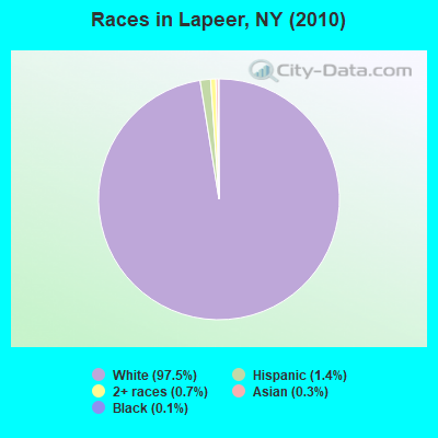
Races in Lapeer detailed stats: ancestries, foreign born residents, place of birth
 Recent articles from our blog. Our writers, many of them Ph.D. graduates or candidates, create easy-to-read articles on a wide variety of topics.


Latest news from Lapeer, NY collected exclusively by city-data.com from local newspapers, TV, and radio stations
Ancestries: Irish (22.9%), German (20.4%), English (17.9%), United States (9.8%), French (3.6%), Swedish (2.5%).
Current Local Time: EST time zone
Elevation: 1326 feet
Land area: 25.1 square miles.
Population density: 31 people per square mile (very low).
2 residents are foreign born
| This town: | 0.3% |
| New York: | 20.4% |
| Lapeer town: | 2.4% ($1,688) |
| New York: | 1.9% ($2,847) |
Nearest city with pop. 50,000+: Union, NY (23.1 miles  , pop. 56,298).
Nearest city with pop. 200,000+: Rochester, NY (91.3 miles , pop. 219,773).
Nearest city with pop. 1,000,000+: Bronx, NY (159.6 miles , pop. 1,332,650).
Nearest cities:
), ), ), ), ), ), ), )Latitude: 42.44 N, Longitude: 76.11 W
Area code commonly used in this area: 607

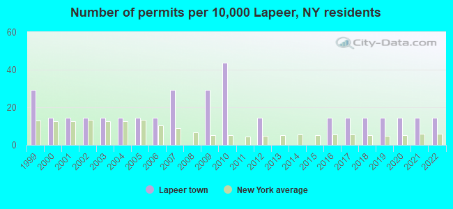
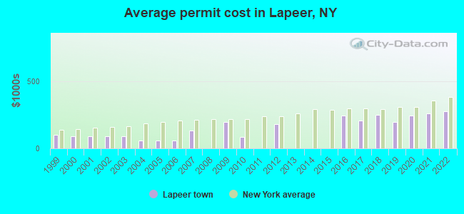
Single-family new house construction building permits:
- 2022: 1 building, cost: $279,200
- 2021: 1 building, cost: $259,200
- 2020: 1 building, cost: $248,200
- 2019: 1 building, cost: $200,000
- 2018: 1 building, cost: $249,800
- 2017: 1 building, cost: $210,000
- 2016: 1 building, cost: $246,000
- 2012: 1 building, cost: $184,000
- 2010: 3 buildings, average cost: $85,000
- 2009: 2 buildings, average cost: $195,000
- 2007: 2 buildings, average cost: $130,500
- 2006: 1 building, cost: $60,000
- 2005: 1 building, cost: $60,000
- 2004: 1 building, cost: $60,000
- 2003: 1 building, cost: $90,000
- 2002: 1 building, cost: $90,000
- 2001: 1 building, cost: $90,000
- 2000: 1 building, cost: $90,000
- 1999: 2 buildings, average cost: $103,100
| Here: | 5.0% |
| New York: | 4.4% |
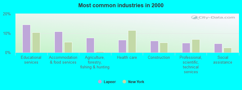
- Educational services (14.4%)
- Accommodation & food services (10.9%)
- Agriculture, forestry, fishing & hunting (7.6%)
- Health care (6.5%)
- Construction (6.0%)
- Professional, scientific, technical services (4.9%)
- Social assistance (4.6%)
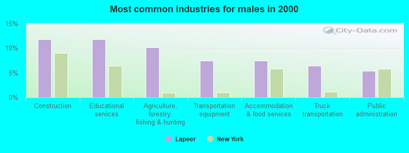
- Construction (11.8%)
- Educational services (11.8%)
- Agriculture, forestry, fishing & hunting (10.2%)
- Transportation equipment (7.5%)
- Accommodation & food services (7.5%)
- Truck transportation (6.4%)
- Public administration (5.3%)
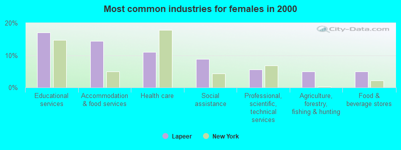
- Educational services (17.1%)
- Accommodation & food services (14.4%)
- Health care (11.0%)
- Social assistance (8.8%)
- Professional, scientific, technical services (5.5%)
- Agriculture, forestry, fishing & hunting (5.0%)
- Food & beverage stores (5.0%)
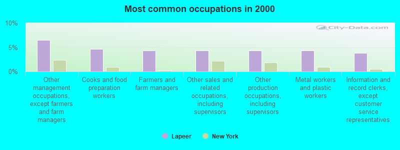
- Other management occupations, except farmers and farm managers (6.5%)
- Cooks and food preparation workers (4.6%)
- Farmers and farm managers (4.3%)
- Other sales and related occupations, including supervisors (4.3%)
- Other production occupations, including supervisors (4.3%)
- Metal workers and plastic workers (4.3%)
- Information and record clerks, except customer service representatives (3.8%)
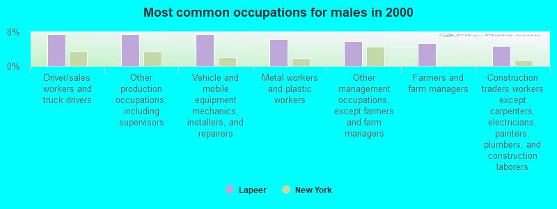
- Driver/sales workers and truck drivers (7.5%)
- Other production occupations, including supervisors (7.5%)
- Vehicle and mobile equipment mechanics, installers, and repairers (7.5%)
- Metal workers and plastic workers (6.4%)
- Other management occupations, except farmers and farm managers (5.9%)
- Farmers and farm managers (5.3%)
- Construction traders workers except carpenters, electricians, painters, plumbers, and construction laborers (4.8%)

- Other management occupations, except farmers and farm managers (7.2%)
- Other teachers, instructors, education, training, and library occupations (6.6%)
- Other office and administrative support workers, including supervisors (6.6%)
- Information and record clerks, except customer service representatives (6.1%)
- Cooks and food preparation workers (6.1%)
- Other sales and related occupations, including supervisors (6.1%)
- Food and beverage serving workers, except waiters and waitresses (5.0%)
Average climate in Lapeer, New York
Based on data reported by over 4,000 weather stations


Tornado activity:
Lapeer-area historical tornado activity is slightly below New York state average. It is 67% smaller than the overall U.S. average.
On 5/31/1998, a category F3 (max. wind speeds 158-206 mph) tornado 25.9 miles away from the Lapeer town center injured 12 people and caused $3 million in damages.
On 5/2/1983, a category F3 tornado 30.6 miles away from the town center injured 6 people and caused between $500,000 and $5,000,000 in damages.
Earthquake activity:
Lapeer-area historical earthquake activity is significantly above New York state average. It is 67% smaller than the overall U.S. average.On 10/7/1983 at 10:18:46, a magnitude 5.3 (5.1 MB, 5.3 LG, 5.1 ML, Class: Moderate, Intensity: VI - VII) earthquake occurred 137.2 miles away from the city center
On 4/20/2002 at 10:50:47, a magnitude 5.3 (5.3 ML, Depth: 3.0 mi) earthquake occurred 187.3 miles away from the city center
On 4/20/2002 at 10:50:47, a magnitude 5.2 (5.2 MB, 4.2 MS, 5.2 MW, 5.0 MW) earthquake occurred 185.3 miles away from Lapeer center
On 8/23/2011 at 17:51:04, a magnitude 5.8 (5.8 MW, Depth: 3.7 mi) earthquake occurred 328.1 miles away from Lapeer center
On 9/25/1998 at 19:52:52, a magnitude 5.2 (4.8 MB, 4.3 MS, 5.2 LG, 4.5 MW, Depth: 3.1 mi) earthquake occurred 230.2 miles away from the city center
On 1/16/1994 at 01:49:16, a magnitude 4.6 (4.6 MB, 4.6 LG, Depth: 3.1 mi, Class: Light, Intensity: IV - V) earthquake occurred 146.2 miles away from the city center
Magnitude types: regional Lg-wave magnitude (LG), body-wave magnitude (MB), local magnitude (ML), surface-wave magnitude (MS), moment magnitude (MW)
Natural disasters:
The number of natural disasters in Cortland County (14) is near the US average (15).Major Disasters (Presidential) Declared: 7
Emergencies Declared: 5
Causes of natural disasters: Floods: 7, Storms: 7, Hurricanes: 2, Blizzard: 1, Heavy Rain: 1, Landslide: 1, Power Outage: 1, Snowstorm: 1, Wind: 1, Winter Storm: 1, Other: 2 (Note: some incidents may be assigned to more than one category).
Hospitals and medical centers near Lapeer:
- CROWN CENTER FOR NURSING AND REHABILITATION (Nursing Home, about 11 miles away; CORTLAND, NY)
- CORTLAND COUNTY HEALTH DEPARTMENT (Home Health Center, about 12 miles away; CORTLAND, NY)
- ST. JOSEPH'S - CORTLAND (Dialysis Facility, about 12 miles away; CORTLAND, NY)
- CORTLAND PARK REHABILITATION AND NURSING CENTER (Nursing Home, about 13 miles away; CORTLAND, NY)
- CARING COMMUNITY HOSPICE OF CORTLAND (Hospital, about 13 miles away; CORTLAND, NY)
- CORTLAND REGIONAL MEDICAL CENTER, INC Acute Care Hospitals (about 13 miles away; CORTLAND, NY)
Colleges/universities with over 2000 students nearest to Lapeer:
- Tompkins Cortland Community College (about 11 miles; Dryden, NY; Full-time enrollment: 3,884)
- SUNY College at Cortland (about 12 miles; Cortland, NY; FT enrollment: 6,838)
- Cornell University (about 20 miles; Ithaca, NY; FT enrollment: 20,360)
- Ithaca College (about 20 miles; Ithaca, NY; FT enrollment: 6,781)
- SUNY Broome Community College (about 24 miles; Binghamton, NY; FT enrollment: 4,969)
- SUNY at Binghamton (about 26 miles; Vestal, NY; FT enrollment: 15,096)
- Colgate University (about 39 miles; Hamilton, NY; FT enrollment: 3,094)
Points of interest:
Notable location: Country Hills Campground (A). Display/hide its location on the map
Church in Lapeer: Lapeer Church (A). Display/hide its location on the map
Cemeteries: Hunts Corners Cemetery (1), Quail Hill Cemetery (2), Parker Street Cemetery (3). Display/hide their locations on the map
Reservoir: Beaver Pond (A). Display/hide its location on the map
| This town: | 2.8 people |
| New York: | 2.6 people |
| This town: | 77.7% |
| Whole state: | 63.5% |
| This town: | 8.8% |
| Whole state: | 6.8% |
Likely homosexual households (counted as self-reported same-sex unmarried-partner households)
- Lesbian couples: 0.4% of all households
- Gay men: 0.0% of all households
| This town: | 10.7% |
| Whole state: | 14.6% |
| This town: | 4.8% |
| Whole state: | 7.4% |
For population 15 years and over in Lapeer:
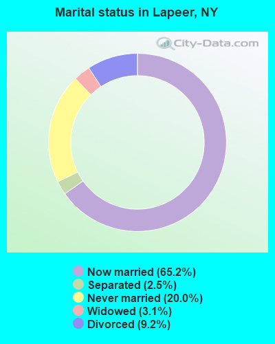
- Never married: 20.0%
- Now married: 65.2%
- Separated: 2.5%
- Widowed: 3.1%
- Divorced: 9.2%
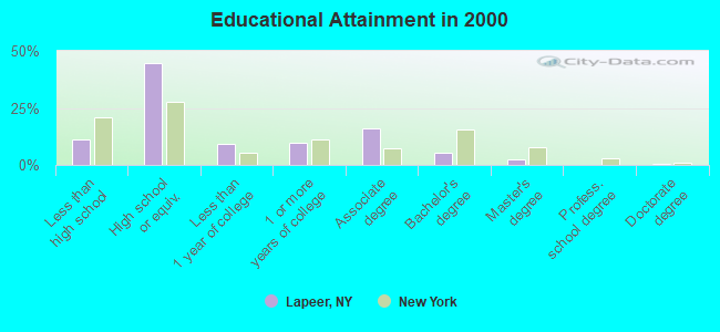
For population 25 years and over in Lapeer:
- High school or higher: 89.0%
- Bachelor's degree or higher: 8.7%
- Graduate or professional degree: 3.3%
- Unemployed: 5.4%
- Mean travel time to work (commute): 26.0 minutes
| Here: | 9.0 |
| New York average: | 14.2 |
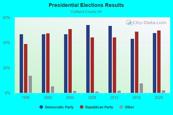
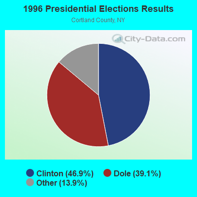
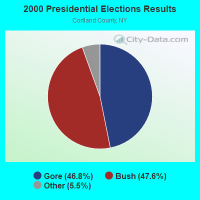
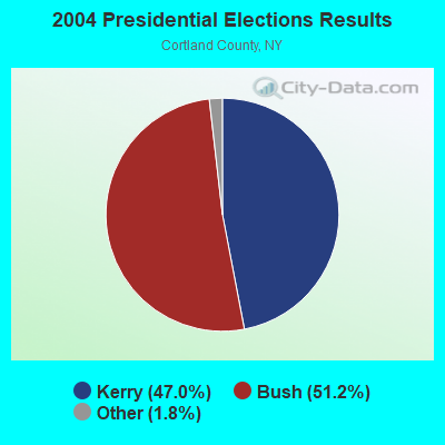
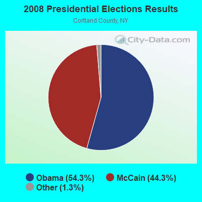

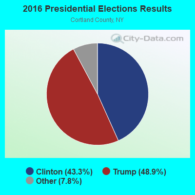

Graphs represent county-level data. Detailed 2008 Election Results
Religion statistics for Lapeer, NY (based on Cortland County data)
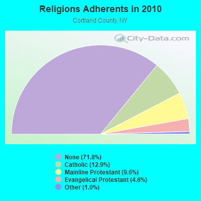
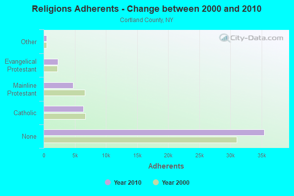
| Religion | Adherents | Congregations |
|---|---|---|
| Catholic | 6,378 | 5 |
| Mainline Protestant | 4,756 | 25 |
| Evangelical Protestant | 2,291 | 29 |
| Other | 483 | 6 |
| None | 35,428 | - |
Food Environment Statistics:
| This county: | 2.48 / 10,000 pop. |
| New York: | 4.13 / 10,000 pop. |
| Cortland County: | 0.41 / 10,000 pop. |
| State: | 0.92 / 10,000 pop. |
| This county: | 3.92 / 10,000 pop. |
| New York: | 1.68 / 10,000 pop. |
| Cortland County: | 9.29 / 10,000 pop. |
| State: | 8.82 / 10,000 pop. |
| Cortland County: | 7.4% |
| State: | 8.2% |
| Here: | 24.5% |
| New York: | 23.8% |
| Cortland County: | 11.7% |
| New York: | 15.6% |
Strongest AM radio stations in Lapeer:
- WHCU (870 AM; 5 kW; ITHACA, NY; Owner: EAGLE BROADCASTING COMPANY, INC.)
- WKRT (920 AM; 1 kW; CORTLAND, NY; Owner: CITADEL BROADCASTING COMPANY)
- WINR (680 AM; 5 kW; BINGHAMTON, NY; Owner: CLEVELAND RADIO LICENSES, LLC)
- WNBF (1290 AM; 9 kW; BINGHAMTON, NY; Owner: CITADEL BROADCASTING COMPANY)
- WTKO (1470 AM; 5 kW; ITHACA, NY; Owner: EAGLE II BROADCASTING CORPORATION)
- WEBO (1330 AM; 5 kW; OWEGO, NY; Owner: TIOGA MEDIA, INC.)
- WSYR (570 AM; 5 kW; SYRACUSE, NY; Owner: CLEAR CHANNEL BROADCASTING LICENSES, INC.)
- WENE (1430 AM; 5 kW; ENDICOTT, NY; Owner: CLEAR CHANNEL BROADCASTING LICENSES, INC.)
- WGY (810 AM; 50 kW; SCHENECTADY, NY; Owner: CLEAR CHANNEL BROADCASTING LICENSES, INC.)
- WHAM (1180 AM; 50 kW; ROCHESTER, NY; Owner: CITICASTERS LICENSES, L.P.)
- WYOS (1360 AM; 5 kW; BINGHAMTON, NY; Owner: CITADEL BROADCASTING COMPANY)
- WPIE (1160 AM; 5 kW; TRUMANSBURG, NY; Owner: PEMBROOK PINES ITHACA LTD. N.A.)
- WATS (960 AM; 5 kW; SAYRE, PA; Owner: WATS BROADCASTING, INC.)
Strongest FM radio stations in Lapeer:
- WIII (99.9 FM; CORTLAND, NY; Owner: CITADEL BROADCASTING COMPANY)
- WYXL (97.3 FM; ITHACA, NY; Owner: EAGLE BROADCASTING COMPANY)
- WHWK (98.1 FM; BINGHAMTON, NY; Owner: CITADEL BROADCASTING COMPANY)
- WAAL (99.1 FM; BINGHAMTON, NY; Owner: CITADEL BROADCASTING COMPANY)
- WSQX-FM (91.5 FM; BINGHAMTON, NY; Owner: WSKG PUBLIC TELECOMMUNICATIONS CNCL.)
- WSKG-FM (89.3 FM; BINGHAMTON, NY; Owner: WSKG PUB.TELECOMMUNICATIONS COUNCIL)
- WMXW (103.3 FM; VESTAL, NY; Owner: CLEAR CHANNEL BROADCASTING LICENSES, INC.)
- WXHC (101.5 FM; HOMER, NY; Owner: EVES BROADCASTING, INC.)
- WLTB (101.7 FM; JOHNSON CITY, NY; Owner: GM BROADCASTING, INC.)
- WWYL (104.1 FM; CHENANGO BRIDGE, NY; Owner: CITADEL BROADCASTING COMPANY)
- WQNY (103.7 FM; ITHACA, NY; Owner: EAGLE II BROADCASTING CORPORATION)
- WPHR (106.9 FM; AUBURN, NY; Owner: CLEAR CHANNEL BROADCASTING LICENSES, INC.)
- WMRV-FM (105.7 FM; ENDICOTT, NY; Owner: CLEAR CHANNEL BROADCASTING LICENSES, INC.)
- WKGB-FM (92.5 FM; CONKLIN, NY; Owner: CLEAR CHANNEL BROADCASTING LICENSES, INC.)
- WBBI (107.5 FM; ENDWELL, NY; Owner: CLEAR CHANNEL BROADCASTING LICENSES, INC.)
- WBKT (95.3 FM; NORWICH, NY; Owner: BANJO COMMUNICATIONS GROUP, INC)
- W273AB (102.5 FM; OWEGO, NY; Owner: WEBO RADIO, INC.)
- WKXZ (93.9 FM; NORWICH, NY; Owner: BANJO COMMUNICATIONS GROUP, INC)
- WCNY-FM (91.3 FM; SYRACUSE, NY; Owner: THE PUB. B/C COUNC. OF CEN. NY, INC.)
- WMHR (102.9 FM; SYRACUSE, NY; Owner: MARS HILL BROADCASTING CO., INC.)
TV broadcast stations around Lapeer:
- WSKG-TV (Channel 46; BINGHAMTON, NY; Owner: WSKG PUBLIC TELECOMMUNICATIONS COUNCIL)
- WICZ-TV (Channel 40; BINGHAMTON, NY; Owner: STAINLESS BROADCASTING, L.P.)
- WIXT-TV (Channel 9; SYRACUSE, NY; Owner: CENTRAL NY NEWS, INC.)
- WCNY-TV (Channel 24; SYRACUSE, NY; Owner: PUBLIC BROADCASTING COUNCIL OF CENTRAL NEW YORK)
- WSYT (Channel 68; SYRACUSE, NY; Owner: WSYT LICENSEE L.P.)
- WSTM-TV (Channel 3; SYRACUSE, NY; Owner: WSTM LICENSE SUBSIDIARY, INC.)
- WBNG-TV (Channel 12; BINGHAMTON, NY; Owner: TELEVISION STATION GROUP LICENSE SUBSIDIARY, LLC)
- WNYS-TV (Channel 43; SYRACUSE, NY; Owner: RKM MEDIA, INC.)
- W26BS (Channel 14; BINGHAMTON, NY; Owner: TRINITY BROADCASTING NETWORK)
- WIVT (Channel 34; BINGHAMTON, NY; Owner: CENTRAL NY NEWS, INC.)
- WBPN-LP (Channel 10; BINGHAMTON, NY; Owner: STAINLESS BROADCASTING, L.P.)
- W16AX (Channel 16; ITHACA, NY; Owner: WSYT LICENSEE L.P.)
- WBGH-CA (Channel 20; BINGHAMTON, NY; Owner: CENTRAL NY NEWS, INC.)
- National Bridge Inventory (NBI) Statistics
- 5Number of bridges
- 23ft / 6.8mTotal length
- $3,543,000Total costs
- 2,650Total average daily traffic
- 289Total average daily truck traffic
- 3,705Total future (year 2039) average daily traffic
FCC Registered Antenna Towers:
4- David L Tanner, 1767 Fritts Hill Rd (Lat: 42.459361 Lon: -76.157361), Type: 92.7, Structure height: 36023 m, Overall height: 91.4 m, Registrant: Cortland County, Dtanner@cortland-Co.Org, , Cortl-and, Phone: (607) 753-3311
- David L Tanner, 1767 Fritts Hill Rd (Lat: 42.459361 Lon: -76.157361), Type: 92.7, Structure height: 36023 m, Overall height: 91.4 m, Registrant: Cortland County, Dtanner@cortland-Co.Org, , Cortl-and, Phone: (607) 753-3311
- David L Tanner, 1767 Fritts Hill Rd (Lat: 42.459361 Lon: -76.157361), Type: 92.7, Structure height: 36023 m, Overall height: 91.4 m, Registrant: Cortland County, Dtanner@cortland-Co.Org, , Cortl-and, Phone: (607) 753-3311
- Scott Roman, 1767 Fritts Hill Rd (Lat: 42.459361 Lon: -76.157361), Type: 92.7, Structure height: 36023 m, Overall height: 91.4 m, Licensee ID: G, Registrant: Cortland County, Sroman@cortland-Co.Org, , Cortl-and, Phone: (607) 753-5064
FCC Registered Microwave Towers:
3- FRITTS, 1767 Fritts Hill Rd (Lat: 42.459389 Lon: -76.157472), Type: Ltower, Structure height: 91.4 m, Overall height: 92.7 m, Call Sign: WQRJ254,
Assigned Frequencies: 6197.24 MHz, 6345.49 MHz, Grant Date: 02/24/2023, Expiration Date: 05/24/2033, Certifier: David Tanner, Registrant: Cortland County 911, 54 Greenbush Street; Suite 201, Cortland, NY 13045, Phone: (607) 753-5064, Fax: (607) 756-8457, Email:
- LAPEER, 1767 Fritts Hill Rd (Lat: 42.459361 Lon: -76.157361), Type: Ltower, Structure height: 91.4 m, Overall height: 92.7 m, Call Sign: WQXA550,
Assigned Frequencies: 6375.14 MHz, Grant Date: 01/13/2016, Expiration Date: 01/13/2026, Certifier: Lee Shurtleff, Registrant: Blue Wing Services, Inc, 329 Laurel Dr, Trappe, PA 19426, Phone: (610) 624-1801, Email:
- LAPEER, 1767 Fritts Hill Rd (Lat: 42.459361 Lon: -76.157361), Type: Ltower, Structure height: 91.4 m, Overall height: 92.7 m, Call Sign: WRDY287,
Assigned Frequencies: 6271.36 MHz, 6271.36 MHz, 6271.36 MHz, 6271.36 MHz, 6271.36 MHz, 6271.36 MHz, 6271.36 MHz, 6271.36 MHz, Grant Date: 08/19/2019, Expiration Date: 08/19/2029, Certifier: Tom Vroman, Registrant: County Of Broome, 153 Lt. Vanwinkle Drive, Binghamton, NY 13905, Phone: (607) 778-8214, Email:
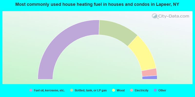
- 51.0%Fuel oil, kerosene, etc.
- 22.5%Bottled, tank, or LP gas
- 20.5%Wood
- 4.0%Electricity
- 1.0%Utility gas
- 1.0%Coal or coke
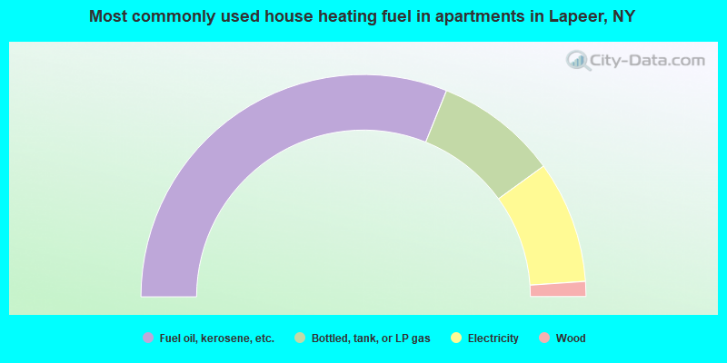
- 62.2%Fuel oil, kerosene, etc.
- 17.8%Bottled, tank, or LP gas
- 17.8%Electricity
- 2.2%Wood
Lapeer compared to New York state average:
- Median house value significantly below state average.
- Unemployed percentage below state average.
- Black race population percentage significantly below state average.
- Hispanic race population percentage significantly below state average.
- Foreign-born population percentage significantly below state average.
- Renting percentage significantly below state average.
- Length of stay since moving in significantly above state average.
- Number of rooms per house significantly below state average.
- House age significantly below state average.
- Percentage of population with a bachelor's degree or higher significantly below state average.