Latonia Lakes, Kentucky
Submit your own pictures of this city and show them to the world
- OSM Map
- General Map
- Google Map
- MSN Map
| Males: 176 | |
| Females: 160 |
| Median resident age: | 35.6 years |
| Kentucky median age: | 35.9 years |
Zip codes: 41015.
| Latonia Lakes: | $40,973 |
| KY: | $59,341 |
Estimated per capita income in 2022: $24,329 (it was $12,876 in 2000)
Latonia Lakes city income, earnings, and wages data
Estimated median house or condo value in 2022: $91,061 (it was $42,000 in 2000)
| Latonia Lakes: | $91,061 |
| KY: | $196,300 |
Mean prices in 2022: all housing units: $242,255; detached houses: $245,043; townhouses or other attached units: $258,669; in 2-unit structures: $263,395; in 3-to-4-unit structures: $160,357; in 5-or-more-unit structures: $260,726; mobile homes: $48,114
Detailed information about poverty and poor residents in Latonia Lakes, KY


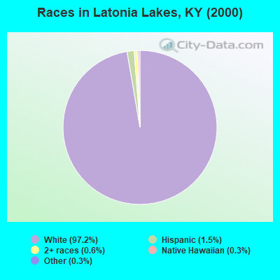
- 31697.2%White alone
- 51.5%Hispanic
- 20.6%Two or more races
- 10.3%Native Hawaiian and Other
Pacific Islander alone - 10.3%Other race alone
Races in Latonia Lakes detailed stats: ancestries, foreign born residents, place of birth
 Recent articles from our blog. Our writers, many of them Ph.D. graduates or candidates, create easy-to-read articles on a wide variety of topics.

Latest news from Latonia Lakes, KY collected exclusively by city-data.com from local newspapers, TV, and radio stations
Ancestries: United States (30.5%), German (9.5%), Irish (5.2%), Dutch (1.8%), French (1.8%), Scotch-Irish (1.2%).
Current Local Time: EST time zone
Incorporated on 07/13/1953
Land area: 0.30 square miles.
Population density: 1,131 people per square mile (low).
| Latonia Lakes city: | 0.6% ($269) |
| Kentucky: | 0.8% ($610) |
Nearest city with pop. 50,000+: Cincinnati, OH  (11.6 miles , pop. 331,285).
Nearest city with pop. 1,000,000+: Chicago, IL (259.8 miles , pop. 2,896,016).
Nearest cities:
), ), ), )Latitude: 38.97 N, Longitude: 84.50 W
Area code commonly used in this area: 859
| Here: | 3.4% |
| Kentucky: | 3.8% |
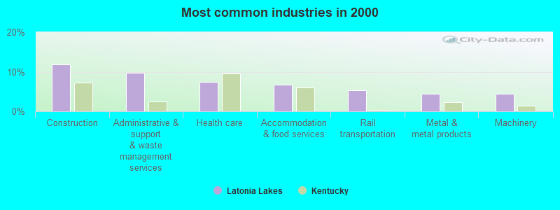
- Construction (11.9%)
- Administrative & support & waste management services (9.7%)
- Health care (7.5%)
- Accommodation & food services (6.7%)
- Rail transportation (5.2%)
- Metal & metal products (4.5%)
- Machinery (4.5%)
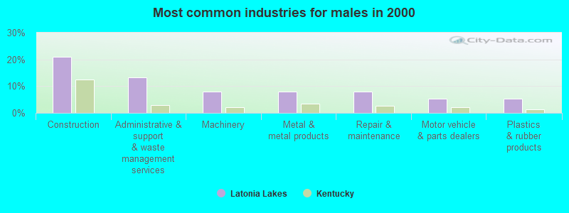
- Construction (21.1%)
- Administrative & support & waste management services (13.2%)
- Machinery (7.9%)
- Metal & metal products (7.9%)
- Repair & maintenance (7.9%)
- Motor vehicle & parts dealers (5.3%)
- Plastics & rubber products (5.3%)
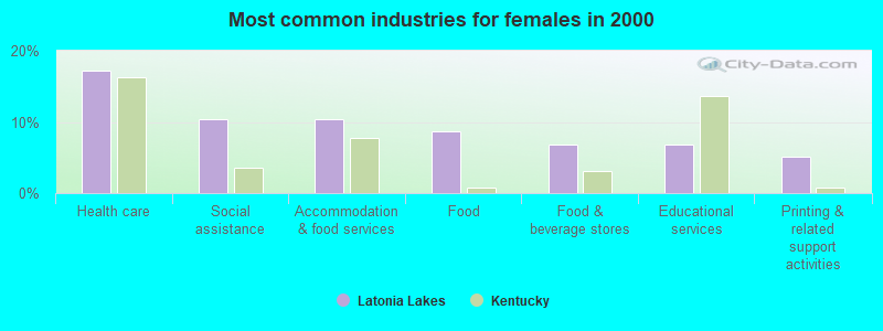
- Health care (17.2%)
- Social assistance (10.3%)
- Accommodation & food services (10.3%)
- Food (8.6%)
- Food & beverage stores (6.9%)
- Educational services (6.9%)
- Printing & related support activities (5.2%)
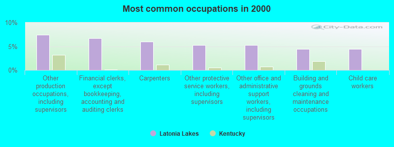
- Other production occupations, including supervisors (7.5%)
- Financial clerks, except bookkeeping, accounting and auditing clerks (6.7%)
- Carpenters (6.0%)
- Other protective service workers, including supervisors (5.2%)
- Other office and administrative support workers, including supervisors (5.2%)
- Building and grounds cleaning and maintenance occupations (4.5%)
- Child care workers (4.5%)
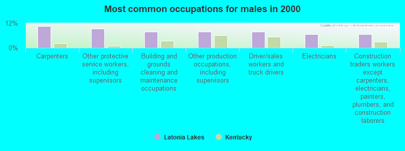
- Carpenters (10.5%)
- Other protective service workers, including supervisors (9.2%)
- Building and grounds cleaning and maintenance occupations (7.9%)
- Other production occupations, including supervisors (7.9%)
- Driver/sales workers and truck drivers (7.9%)
- Electricians (6.6%)
- Construction traders workers except carpenters, electricians, painters, plumbers, and construction laborers (6.6%)
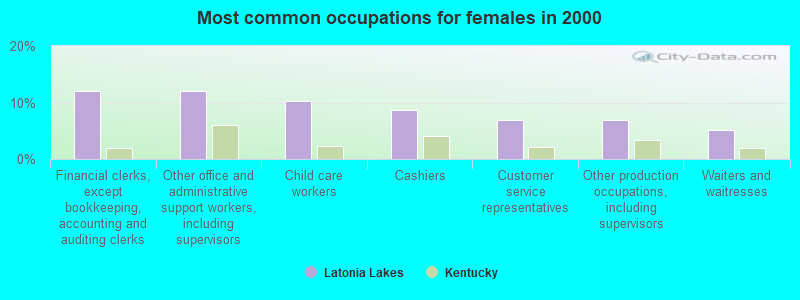
- Financial clerks, except bookkeeping, accounting and auditing clerks (12.1%)
- Other office and administrative support workers, including supervisors (12.1%)
- Child care workers (10.3%)
- Cashiers (8.6%)
- Customer service representatives (6.9%)
- Other production occupations, including supervisors (6.9%)
- Waiters and waitresses (5.2%)
Average climate in Latonia Lakes, Kentucky
Based on data reported by over 4,000 weather stations


(lower is better)
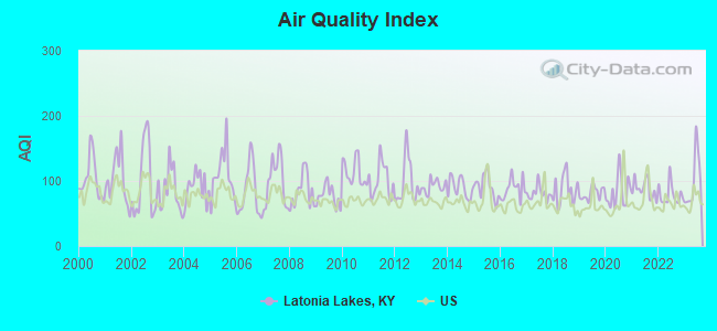
Air Quality Index (AQI) level in 2023 was 100. This is worse than average.
| City: | 100 |
| U.S.: | 73 |
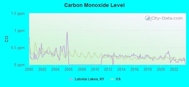
Carbon Monoxide (CO) [ppm] level in 2023 was 0.138. This is significantly better than average. Closest monitor was 6.4 miles away from the city center.
| City: | 0.138 |
| U.S.: | 0.251 |
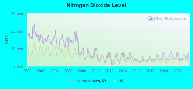
Nitrogen Dioxide (NO2) [ppb] level in 2023 was 5.53. This is about average. Closest monitor was 3.9 miles away from the city center.
| City: | 5.53 |
| U.S.: | 5.11 |
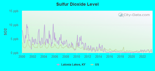
Sulfur Dioxide (SO2) [ppb] level in 2023 was 0.748. This is significantly better than average. Closest monitor was 3.9 miles away from the city center.
| City: | 0.748 |
| U.S.: | 1.515 |
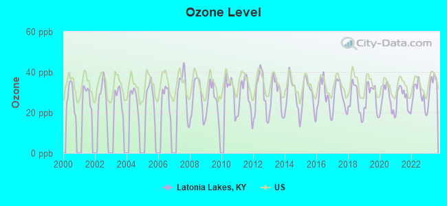
Ozone [ppb] level in 2023 was 33.1. This is about average. Closest monitor was 3.9 miles away from the city center.
| City: | 33.1 |
| U.S.: | 33.3 |
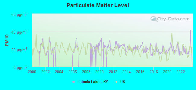
Particulate Matter (PM10) [µg/m3] level in 2023 was 21.0. This is about average. Closest monitor was 7.0 miles away from the city center.
| City: | 21.0 |
| U.S.: | 19.2 |
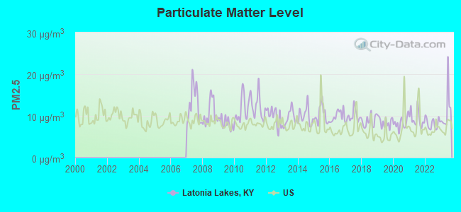
Particulate Matter (PM2.5) [µg/m3] level in 2023 was 11.2. This is worse than average. Closest monitor was 3.9 miles away from the city center.
| City: | 11.2 |
| U.S.: | 8.1 |
Tornado activity:
Latonia Lakes-area historical tornado activity is slightly above Kentucky state average. It is 60% greater than the overall U.S. average.
On 4/3/1974, a category F5 (max. wind speeds 261-318 mph) tornado 18.8 miles away from the Latonia Lakes city center killed 3 people and injured 210 people.
On 4/3/1974, a category F4 (max. wind speeds 207-260 mph) tornado 14.7 miles away from the city center killed 2 people and injured 39 people and caused between $50,000 and $500,000 in damages.
Earthquake activity:
Latonia Lakes-area historical earthquake activity is significantly above Kentucky state average. It is 52% greater than the overall U.S. average.On 7/27/1980 at 18:52:21, a magnitude 5.2 (5.1 MB, 4.7 MS, 5.0 UK, 5.2 UK, Class: Moderate, Intensity: VI - VII) earthquake occurred 60.7 miles away from the city center
On 4/18/2008 at 09:36:59, a magnitude 5.4 (5.1 MB, 4.8 MS, 5.4 MW, 5.2 MW) earthquake occurred 186.3 miles away from the city center
On 4/18/2008 at 09:36:59, a magnitude 5.2 (5.2 MW, Depth: 8.9 mi) earthquake occurred 186.3 miles away from the city center
On 9/7/1988 at 02:28:09, a magnitude 4.6 (4.5 MB, 4.6 LG, Class: Light, Intensity: IV - V) earthquake occurred 66.2 miles away from the city center
On 6/10/1987 at 23:48:54, a magnitude 5.1 (4.9 MB, 4.4 MS, 4.6 MS, 5.1 LG) earthquake occurred 182.6 miles away from the city center
On 6/18/2002 at 17:37:15, a magnitude 5.0 (4.3 MB, 4.6 MW, 5.0 LG) earthquake occurred 190.2 miles away from Latonia Lakes center
Magnitude types: regional Lg-wave magnitude (LG), body-wave magnitude (MB), surface-wave magnitude (MS), moment magnitude (MW)
Natural disasters:
The number of natural disasters in Kenton County (10) is smaller than the US average (15).Major Disasters (Presidential) Declared: 6
Emergencies Declared: 2
Causes of natural disasters: Floods: 5, Storms: 5, Tornadoes: 3, Winds: 2, Winter Storms: 2, Blizzard: 1, Hurricane: 1, Landslide: 1, Mudslide: 1, Tropical Depression: 1, Other: 1 (Note: some incidents may be assigned to more than one category).
Hospitals and medical centers near Latonia Lakes:
- HEALTHSOUTH NORTHERN KENTUCKY REHABILITATION (Hospital, about 5 miles away; EDGEWOOD, KY)
- LAKESIDE HEIGHTS NURSING CENTER (Nursing Home, about 5 miles away; HIGHLAND HEIGHTS, KY)
- LAKESIDE PLACE (Nursing Home, about 5 miles away; HIGHLAND HEIGHTS, KY)
- AMEDISYS HOME HEALTH OF KENTUCKY (Home Health Center, about 6 miles away; CRESTVIEW HILLS, KY)
- ROSEDALE MANOR (Nursing Home, about 6 miles away; COVINGTON, KY)
- WOODCREST MANOR CARE CENTER (Nursing Home, about 6 miles away; ELSMERE, KY)
- CARETENDERS OF NORTHERN KY (Home Health Center, about 6 miles away; EDGEWOOD, KY)
Colleges/universities with over 2000 students nearest to Latonia Lakes:
- Northern Kentucky University (about 5 miles; Highland Heights, KY; Full-time enrollment: 12,059)
- Gateway Community and Technical College (about 8 miles; Florence, KY; FT enrollment: 2,422)
- University of Cincinnati-Main Campus (about 12 miles; Cincinnati, OH; FT enrollment: 28,747)
- College of Mount St Joseph (about 12 miles; Cincinnati, OH; FT enrollment: 2,073)
- Xavier University (about 13 miles; Cincinnati, OH; FT enrollment: 6,143)
- Cincinnati State Technical and Community College (about 13 miles; Cincinnati, OH; FT enrollment: 8,757)
- University of Cincinnati-Clermont College (about 19 miles; Batavia, OH; FT enrollment: 2,739)
Points of interest:
| This city: | 2.9 people |
| Kentucky: | 2.5 people |
| This city: | 77.9% |
| Whole state: | 69.8% |
| This city: | 8.0% |
| Whole state: | 4.5% |
Likely homosexual households (counted as self-reported same-sex unmarried-partner households)
- Lesbian couples: 0.0% of all households
- Gay men: 0.9% of all households
| This city: | 24.4% |
| Whole state: | 15.8% |
| This city: | 6.3% |
| Whole state: | 6.6% |
For population 15 years and over in Latonia Lakes:
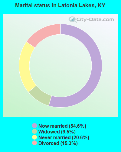
- Never married: 20.6%
- Now married: 54.6%
- Separated: 0.0%
- Widowed: 9.5%
- Divorced: 15.3%
For population 25 years and over in Latonia Lakes:
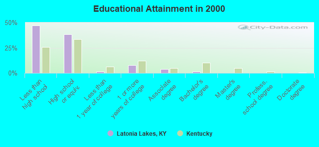
- High school or higher: 52.8%
- Bachelor's degree or higher: 1.4%
- Graduate or professional degree: 0.0%
- Unemployed: 9.5%
- Mean travel time to work (commute): 28.9 minutes
| Here: | 17.5 |
| Kentucky average: | 13.8 |
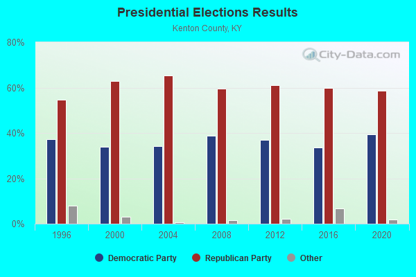
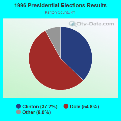
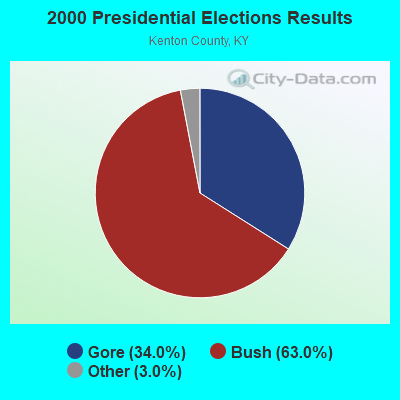
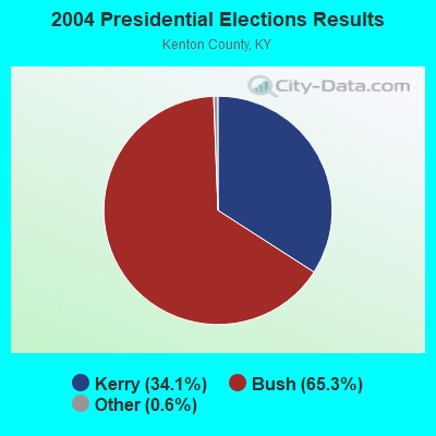

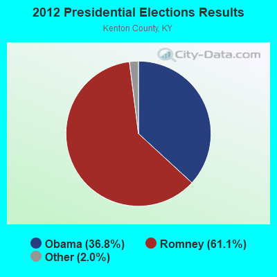
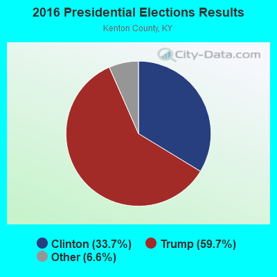
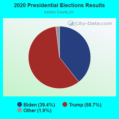
Graphs represent county-level data. Detailed 2008 Election Results
Religion statistics for Latonia Lakes, KY (based on Kenton County data)
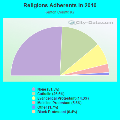
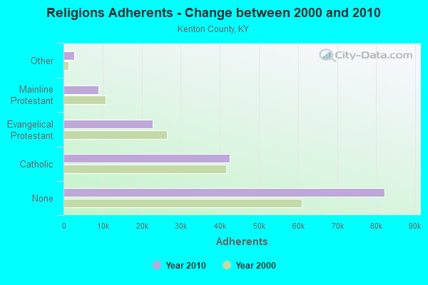
| Religion | Adherents | Congregations |
|---|---|---|
| Catholic | 42,500 | 20 |
| Evangelical Protestant | 22,877 | 85 |
| Mainline Protestant | 8,904 | 30 |
| Other | 2,658 | 8 |
| Black Protestant | 597 | 5 |
| None | 82,184 | - |
Food Environment Statistics:
| This county: | 1.72 / 10,000 pop. |
| State: | 2.19 / 10,000 pop. |
| Here: | 0.96 / 10,000 pop. |
| Kentucky: | 0.74 / 10,000 pop. |
| This county: | 3.32 / 10,000 pop. |
| Kentucky: | 4.36 / 10,000 pop. |
| Kenton County: | 6.90 / 10,000 pop. |
| Kentucky: | 5.74 / 10,000 pop. |
| Here: | 9.4% |
| Kentucky: | 11.0% |
| Kenton County: | 26.9% |
| Kentucky: | 30.0% |
| Kenton County: | 18.3% |
| State: | 15.9% |
| Local government employment and payroll (March 2002) | |||||
| Function | Full-time employees | Monthly full-time payroll | Average yearly full-time wage | Part-time employees | Monthly part-time payroll |
|---|---|---|---|---|---|
| Judicial and Legal | 0 | $0 | 1 | $50 | |
| Other Government Administration | 0 | $0 | 5 | $10 | |
| Financial Administration | 0 | $0 | 1 | $100 | |
| Totals for Government | 0 | $0 | 7 | $160 | |
Strongest AM radio stations in Latonia Lakes:
- WKRC (550 AM; 5 kW; CINCINNATI, OH; Owner: JACOR BROADCASTING CORPORATION)
- WSAI (1530 AM; 50 kW; CINCINNATI, OH; Owner: JACOR BROADCASTING CORPORATION)
- WLW (700 AM; 50 kW; CINCINNATI, OH; Owner: JACOR BROADCASTING CORPORATION)
- WBOB (1160 AM; 5 kW; FLORENCE, KY; Owner: CARON BROADCASTING, INC.)
- WTSJ (1050 AM; 1 kW; CINCINNATI, OH; Owner: CARON BROADCASTING, INC.)
- WNOP (740 AM; 1 kW; NEWPORT, KY; Owner: SACRED HEART RADIO, INC.)
- WCVG (1320 AM; 0 kW; COVINGTON, KY; Owner: RICHARD L. PLESSINGER SR.)
- WCIN (1480 AM; 5 kW; CINCINNATI, OH)
- WHAS (840 AM; 50 kW; LOUISVILLE, KY; Owner: CLEAR CHANNEL BROADCASTING LICENSES, INC.)
- WCKY (1360 AM; 5 kW; CINCINNATI, OH; Owner: JACOR BROADCASTING CORPORATION)
- WTVN (610 AM; 50 kW; COLUMBUS, OH; Owner: CITICASTERS LICENSES, L.P.)
- WDBZ (1230 AM; 1 kW; CINCINNATI, OH; Owner: BLUE CHIP COMMUNICATIONS, INC.)
- WCNW (1560 AM; daytime; 5 kW; FAIRFIELD, OH)
Strongest FM radio stations in Latonia Lakes:
- WVMX (94.1 FM; CINCINNATI, OH; Owner: CITICASTERS LICENSES, L.P.)
- WEBN (102.7 FM; CINCINNATI, OH; Owner: JACOR BROADCASTING CORPORATION)
- WKRQ (101.9 FM; CINCINNATI, OH; Owner: INFINITY RADIO OPERATIONS INC.)
- WKFS (107.1 FM; MILFORD, OH; Owner: JACOR BROADCASTING CORPORATION)
- WUBE-FM (105.1 FM; CINCINNATI, OH; Owner: INFINITY RADIO OPERATIONS INC.)
- WGUC (90.9 FM; CINCINNATI, OH; Owner: CINCINNATI CLASSICAL PUBLIC RADIO, INC.)
- WOFX-FM (92.5 FM; CINCINNATI, OH; Owner: JACOR BROADCASTING CORPORATION)
- WNKU (89.7 FM; HIGHLAND HEIGHTS, KY; Owner: BD. OF REGENTS ON N. KY UNIV.)
- WVXU (91.7 FM; CINCINNATI, OH; Owner: XAVIER UNIVERSITY)
- WGRR (103.5 FM; HAMILTON, OH; Owner: INFINITY RADIO OPERATIONS INC.)
- WIZF (100.9 FM; ERLANGER, KY; Owner: BLUE CHIP BROADCASTING LICENSES II, LTD.)
- WRRM (98.5 FM; CINCINNATI, OH; Owner: WRRM LICO, INC)
- WAIF (88.3 FM; CINCINNATI, OH; Owner: STEPCHILD RADIO OF CINCINNATI, INC.)
- WMOJ (94.9 FM; FAIRFIELD, OH; Owner: WVAE LICO, INC.)
- WAKW (93.3 FM; CINCINNATI, OH; Owner: PILLAR OF FIRE)
- WYGY (96.5 FM; LEBANON, OH; Owner: WVAE LICO, INC.)
- WIOK (107.5 FM; FALMOUTH, KY; Owner: HAMMOND BROADCASTING, INC.)
- WNKR (106.5 FM; WILLIAMSTOWN, KY; Owner: GRANT COUNTY BROADCASTERS, INC)
- WSCH (99.3 FM; AURORA, IN; Owner: COLUMBUS RADIO, INC.)
- WOBO (88.7 FM; BATAVIA, OH; Owner: WCNE EDUCATIONAL COMMUNITY RADIO,INC)
TV broadcast stations around Latonia Lakes:
- WLWT (Channel 5; CINCINNATI, OH; Owner: OHIO/OKLAHOMA HEARST-ARGYLE TV, INC)
- WCPO-TV (Channel 9; CINCINNATI, OH; Owner: SCRIPPS HOWARD BROADCASTING COMPANY)
- WKRC-TV (Channel 12; CINCINNATI, OH; Owner: CITICASTERS CO.)
- WCVN-TV (Channel 54; COVINGTON, KY; Owner: KENTUCKY AUTHORITY FOR EDUCATIONAL TV)
- WXIX-TV (Channel 19; NEWPORT, KY; Owner: RAYCOM NATIONAL, INC.)
- WSTR-TV (Channel 64; CINCINNATI, OH; Owner: WSTR LICENSEE, INC.)
- WCET (Channel 48; CINCINNATI, OH; Owner: THE GREATER CINCINNATI TV EDUC'L. FOUNDATION)
- WOTH-LP (Channel 35; CINCINNATI, OH; Owner: ELLIOTT B. BLOCK)
- WBQC-CA (Channel 25; CINCINNATI, OH; Owner: ELLIOTT B. BLOCK)
- WPTO (Channel 14; OXFORD, OH; Owner: GREATER DAYTON PUBLIC TELEVISION, INC.)
- WKOI (Channel 43; RICHMOND, IN; Owner: TRINITY BROADCASTING OF INDIANA, INC.)
Latonia Lakes fatal accident list:
FCC Registered Broadcast Land Mobile Towers:
4- 1.2 Mi N Of Sr 177 Decoursey Pike & White Rd Int (Lat: 38.978111 Lon: -84.467167), Type: Pole, Structure height: 14 m, Call Sign: KNNQ404, Licensee ID: L00258361,
Assigned Frequencies: 896.887 MHz, 896.937 MHz, 896.987 MHz, 897.887 MHz, 897.937 MHz, 897.987 MHz, Grant Date: 02/11/1998, Expiration Date: 02/11/2003, Cancellation Date: 05/18/2003, Registrant: Association Of American Railroads, 55500 Dot Rd, Pueblo, CO 81001, Phone: (202) 639-2217
- Whites Rd 1000 Ft E Of Sr 177 (Lat: 38.958944 Lon: -84.459389), Type: Pole, Structure height: 20 m, Overall height: 25 m, Call Sign: WNKY563,
Assigned Frequencies: 935.887 MHz, 935.937 MHz, 935.987 MHz, 936.887 MHz, 936.937 MHz, 936.987 MHz, Grant Date: 02/11/1998, Expiration Date: 02/11/2003, Cancellation Date: 04/12/2001, Certifier: Robert Vandeberg, Registrant: Transportation Technology Center Inc, 55500 Dot Road, Pueblo`, CO 81001, Phone: (719) 584-0578, Fax: (719) 584-7145, Email:
- 1.2 Mi N Of Sr 177 Decoursey Pike & White Rd Int (Lat: 38.978111 Lon: -84.467167), Type: Pole, Structure height: 14 m, Overall height: 17 m, Call Sign: KNNR939,
Assigned Frequencies: 160.350 MHz, 160.395 MHz, 160.590 MHz, 160.785 MHz, 161.265 MHz, 161.370 MHz, 161.430 MHz, Grant Date: 01/24/2001, Expiration Date: 04/15/2011, Cancellation Date: 06/18/2011, Certifier: Larry W Allen, Registrant: Business Radio Licensing, 22421 Gilberto Ste D, Rancho Santa Margari, CA 92688, Fax: (714) 459-9153
- .2 Mi E Of Int Of Whites Rd & State Hwy 177 (Lat: 38.958944 Lon: -84.459389), Type: Tower, Structure height: 98 m, Overall height: 99 m, Call Sign: KNNR949,
Assigned Frequencies: 160.350 MHz, 160.395 MHz, 160.590 MHz, 160.785 MHz, 161.265 MHz, 161.370 MHz, 161.430 MHz, Grant Date: 04/16/1996, Expiration Date: 04/16/2001, Cancellation Date: 06/17/2001, Certifier: Larry W Allen, Registrant: Business Radio Licensing, 22421 Gilberto Ste D, Rancho Santa Margari, CA 92688, Fax: (714) 459-9153
FCC Registered Microwave Towers:
2- STATION, 0.2 Mi E Of Int Of Whites Rd And State Hwy 177 (Lat: 38.958944 Lon: -84.459361), Overall height: 98.5 m, Call Sign: WNEH283,
Assigned Frequencies: 2147.60 MHz, 6595.00 MHz, Grant Date: 11/29/1994, Expiration Date: 11/29/1999, Cancellation Date: 03/04/2000, Phone: (904) 359-1329
- STATION, Adj To Whites Rd 2/10 Mi E Int Of Whites Rd & St Hwy 177 (Lat: 38.958944 Lon: -84.459361), Overall height: 98.5 m, Call Sign: WNEI285,
Assigned Frequencies: 6655.00 MHz, 6695.00 MHz, Grant Date: 03/28/1995, Expiration Date: 03/28/2000, Cancellation Date: 07/02/2000, Phone: (904) 359-1329
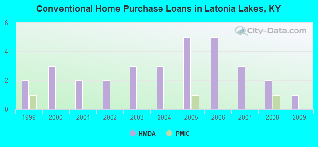
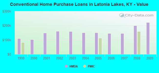
| Home Mortgage Disclosure Act Aggregated Statistics For Year 2009 (Based on 1 partial tract) | ||||||
| A) FHA, FSA/RHS & VA Home Purchase Loans | B) Conventional Home Purchase Loans | C) Refinancings | ||||
|---|---|---|---|---|---|---|
| Number | Average Value | Number | Average Value | Number | Average Value | |
| LOANS ORIGINATED | 1 | $107,660 | 1 | $222,500 | 9 | $152,919 |
| APPLICATIONS APPROVED, NOT ACCEPTED | 0 | $0 | 0 | $0 | 1 | $77,140 |
| APPLICATIONS DENIED | 0 | $0 | 0 | $0 | 3 | $156,840 |
| APPLICATIONS WITHDRAWN | 0 | $0 | 0 | $0 | 1 | $146,090 |
| FILES CLOSED FOR INCOMPLETENESS | 0 | $0 | 0 | $0 | 0 | $0 |
Detailed HMDA statistics for the following Tracts: 0658.00
| Private Mortgage Insurance Companies Aggregated Statistics For Year 2008 (Based on 1 partial tract) | ||
| A) Conventional Home Purchase Loans | ||
|---|---|---|
| Number | Average Value | |
| LOANS ORIGINATED | 1 | $158,700 |
| APPLICATIONS APPROVED, NOT ACCEPTED | 0 | $0 |
| APPLICATIONS DENIED | 0 | $0 |
| APPLICATIONS WITHDRAWN | 0 | $0 |
| FILES CLOSED FOR INCOMPLETENESS | 0 | $0 |
Detailed PMIC statistics for the following Tracts: 0658.00
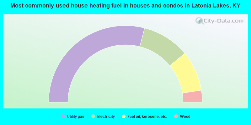
- 58.0%Utility gas
- 20.0%Electricity
- 17.0%Fuel oil, kerosene, etc.
- 5.0%Wood
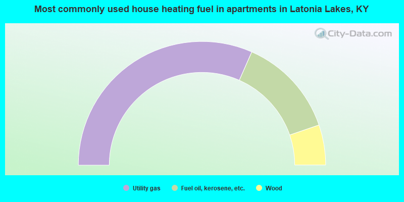
- 63.2%Utility gas
- 26.3%Fuel oil, kerosene, etc.
- 10.5%Wood
Latonia Lakes compared to Kentucky state average:
- Median house value below state average.
- Black race population percentage significantly below state average.
- Hispanic race population percentage below state average.
- Median age below state average.
- Foreign-born population percentage significantly below state average.
- Renting percentage significantly below state average.
- Length of stay since moving in significantly above state average.
- Number of rooms per house significantly below state average.
- House age significantly below state average.
- Percentage of population with a bachelor's degree or higher significantly below state average.