Leoma, Tennessee
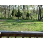
Submit your own pictures of this place and show them to the world
- OSM Map
- General Map
- Google Map
- MSN Map

| Males: 1,767 | |
| Females: 1,741 |
| Median resident age: | 35.4 years |
| Tennessee median age: | 35.9 years |
Zip code: 38468
| Leoma: | $56,329 |
| TN: | $65,254 |
Estimated per capita income in 2022: $25,761 (it was $14,922 in 2000)
Leoma CCD income, earnings, and wages data
Estimated median house or condo value in 2022: $204,960 (it was $77,700 in 2000)
| Leoma: | $204,960 |
| TN: | $284,800 |
Detailed information about poverty and poor residents in Leoma, TN


- 3,35797.9%White alone
- 250.7%Two or more races
- 160.5%American Indian alone
- 170.5%Hispanic
- 120.3%Black alone
- 20.06%Other race alone
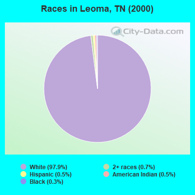
Races in Leoma detailed stats: ancestries, foreign born residents, place of birth
According to our research of Tennessee and other state lists, there were 20 registered sex offenders living in Leoma, Tennessee as of April 23, 2024.
The ratio of all residents to sex offenders in Leoma is 175 to 1.
 Recent articles from our blog. Our writers, many of them Ph.D. graduates or candidates, create easy-to-read articles on a wide variety of topics.
Current Local Time: CST time zone
Elevation: 840 feet
Land area: 60.7 square miles.
Population density: 58 people per square mile (very low).

| Leoma CCD: | 0.6% ($442) |
| Tennessee: | 0.8% ($715) |
Nearest city with pop. 50,000+: Decatur, AL  (43.1 miles , pop. 53,929).
Nearest city with pop. 200,000+: Nashville-Davidson, TN (76.0 miles , pop. 545,524).
Nearest city with pop. 1,000,000+: Chicago, IL (463.4 miles , pop. 2,896,016).
Nearest cities:
), Latitude: 35.15 N, Longitude: 87.30 W
Area code: 931

| Here: | 3.1% |
| Tennessee: | 3.0% |
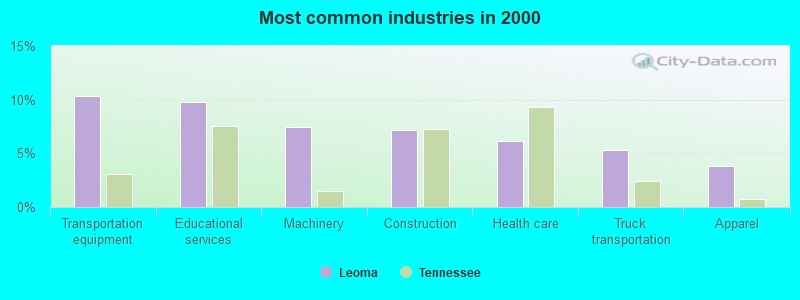
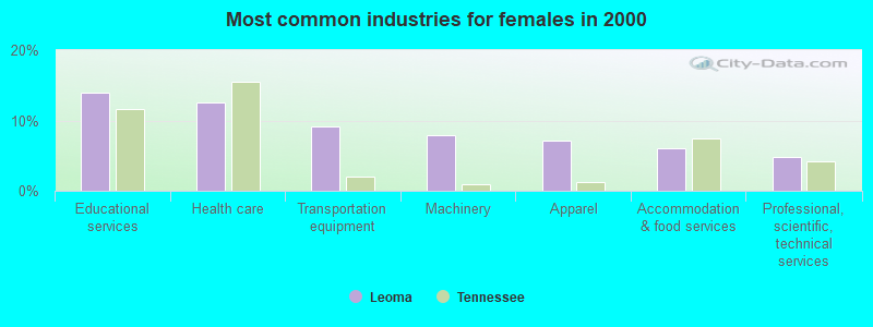
- Transportation equipment (10.4%)
- Educational services (9.8%)
- Machinery (7.4%)
- Construction (7.2%)
- Health care (6.1%)
- Truck transportation (5.3%)
- Apparel (3.8%)
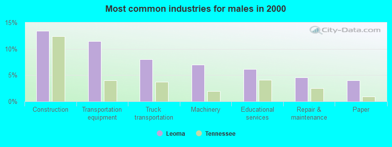
- Construction (13.4%)
- Transportation equipment (11.5%)
- Truck transportation (8.0%)
- Machinery (7.0%)
- Educational services (6.1%)
- Repair & maintenance (4.6%)
- Paper (4.0%)
- Educational services (14.0%)
- Health care (12.6%)
- Transportation equipment (9.1%)
- Machinery (7.9%)
- Apparel (7.1%)
- Accommodation & food services (6.1%)
- Professional, scientific, technical services (4.8%)

- Other production occupations, including supervisors (9.4%)
- Assemblers and fabricators (6.8%)
- Driver/sales workers and truck drivers (5.9%)
- Building and grounds cleaning and maintenance occupations (4.4%)
- Preschool, kindergarten, elementary, and middle school teachers (4.3%)
- Material recording, scheduling, dispatching, and distributing workers (4.1%)
- Metal workers and plastic workers (3.7%)
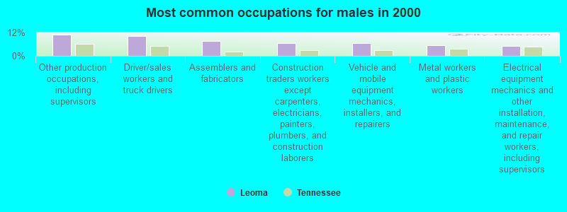
- Other production occupations, including supervisors (10.8%)
- Driver/sales workers and truck drivers (10.0%)
- Assemblers and fabricators (7.5%)
- Construction traders workers except carpenters, electricians, painters, plumbers, and construction laborers (6.6%)
- Vehicle and mobile equipment mechanics, installers, and repairers (6.5%)
- Metal workers and plastic workers (5.5%)
- Electrical equipment mechanics and other installation, maintenance, and repair workers, including supervisors (5.1%)
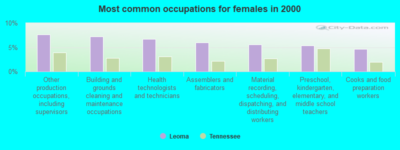
- Other production occupations, including supervisors (7.7%)
- Building and grounds cleaning and maintenance occupations (7.3%)
- Health technologists and technicians (6.7%)
- Assemblers and fabricators (6.0%)
- Material recording, scheduling, dispatching, and distributing workers (5.6%)
- Preschool, kindergarten, elementary, and middle school teachers (5.3%)
- Cooks and food preparation workers (4.7%)
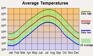
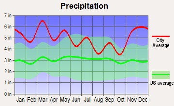
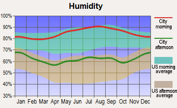
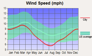
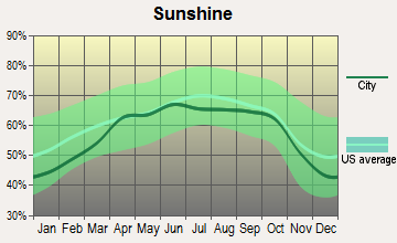
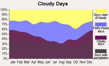
Average climate in Leoma, Tennessee
Based on data reported by over 4,000 weather stations

(lower is better)
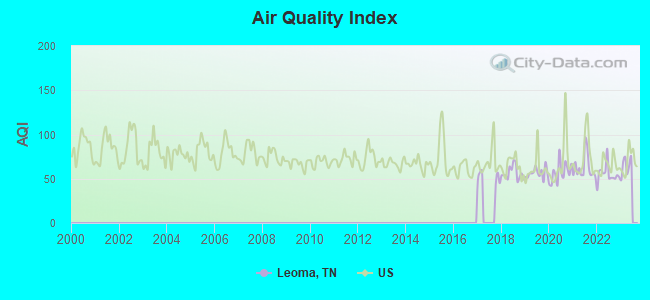
Air Quality Index (AQI) level in 2022 was 55.1. This is better than average.
| City: | 55.1 |
| U.S.: | 72.6 |
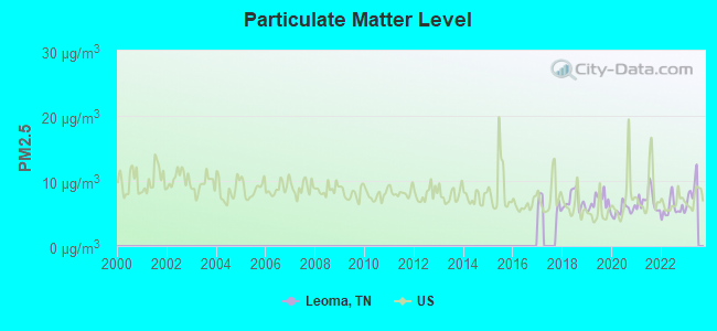
Particulate Matter (PM2.5) [µg/m3] level in 2022 was 5.72. This is significantly better than average. Closest monitor was 7.0 miles away from the city center.
| City: | 5.72 |
| U.S.: | 8.11 |
Tornado activity:
Leoma-area historical tornado activity is above Tennessee state average. It is 109% greater than the overall U.S. average.
On 5/18/1995, a category F4 (max. wind speeds 207-260 mph) tornado 14.4 miles away from the Leoma place center killed 3 people and injured 32 people and caused between $500,000 and $5,000,000 in damages.
On 4/3/1974, a category F5 (max. wind speeds 261-318 mph) tornado 34.0 miles away from the place center killed 16 people and injured 190 people.
Earthquake activity:
Leoma-area historical earthquake activity is significantly above Tennessee state average. It is 210% greater than the overall U.S. average.On 4/29/2003 at 08:59:39, a magnitude 4.9 (4.4 MB, 4.6 MW, 4.9 LG, Class: Light, Intensity: IV - V) earthquake occurred 105.1 miles away from Leoma center
On 4/18/2008 at 09:36:59, a magnitude 5.4 (5.1 MB, 4.8 MS, 5.4 MW, 5.2 MW, Class: Moderate, Intensity: VI - VII) earthquake occurred 230.9 miles away from Leoma center
On 1/18/1999 at 07:00:53, a magnitude 4.8 (4.8 MB, 4.0 LG, Depth: 0.6 mi) earthquake occurred 120.5 miles away from the city center
On 5/4/1991 at 01:18:54, a magnitude 5.0 (4.4 MB, 4.6 LG, 5.0 LG, Depth: 3.1 mi) earthquake occurred 172.0 miles away from Leoma center
On 3/25/1976 at 00:41:20, a magnitude 5.0 (4.9 MB, 5.0 LG) earthquake occurred 173.9 miles away from Leoma center
On 4/29/2003 at 08:59:39, a magnitude 4.6 (4.6 MW, Depth: 12.3 mi) earthquake occurred 105.1 miles away from the city center
Magnitude types: regional Lg-wave magnitude (LG), body-wave magnitude (MB), surface-wave magnitude (MS), moment magnitude (MW)
Natural disasters:
The number of natural disasters in Lawrence County (20) is greater than the US average (15).Major Disasters (Presidential) Declared: 16
Emergencies Declared: 2
Causes of natural disasters: Floods: 13, Storms: 11, Tornadoes: 8, Winds: 5, Winter Storms: 4, Heavy Rains: 2, Flash Flood: 1, Hurricane: 1, Ice Storm: 1, Landslide: 1, Mudslide: 1, Snowfall: 1, Other: 1 (Note: some incidents may be assigned to more than one category).
Hospitals and medical centers near Leoma:
- FMC LAWRENCEBURG (Dialysis Facility, about 6 miles away; LAWRENCEBURG, TN)
- NHC HEALTHCARE, LAWRENCEBURG (Nursing Home, about 8 miles away; LAWRENCEBURG, TN)
- NHC HEALTHCARE, SCOTT (Nursing Home, about 10 miles away; LAWRENCEBURG, TN)
- COUNTRYSIDE HEALTHCARE AND REHABILITATION (Nursing Home, about 11 miles away; LAWRENCEBURG, TN)
Colleges/universities with over 2000 students nearest to Leoma:
- Athens State University (about 31 miles; Athens, AL; Full-time enrollment: 2,771)
- University of North Alabama (about 32 miles; Florence, AL; FT enrollment: 5,886)
- Columbia State Community College (about 35 miles; Columbia, TN; FT enrollment: 3,383)
- Northwest-Shoals Community College (about 36 miles; Muscle Shoals, AL; FT enrollment: 2,702)
- John C Calhoun State Community College (about 40 miles; Tanner, AL; FT enrollment: 7,911)
- University of Alabama in Huntsville (about 48 miles; Huntsville, AL; FT enrollment: 6,006)
- Alabama A & M University (about 49 miles; Normal, AL; FT enrollment: 4,524)
Public elementary/middle school in Leoma:
- LEOMA ELEMENTARY (Students: 479, Location: 2612 HWY 43 SOUTH, Grades: PK-8)
Points of interest:
Notable locations in Leoma: Rabbit Trail Poultry Farm (A), Sherrell Poultry Farms (B), Williams Store (C), Center Point Volunteer Fire Department (D), Leoma Fire and Rescue (E). Display/hide their locations on the map
Churches in Leoma include: Eva Chapel (A), Lindsey Grove Church (B), Fullers Chapel (C), Antioch Church (D), Leoma Baptist Church (E), Center Point Missionary Baptist Church (F), Center Point Methodist Church (G), Bethel Church (H), Cedar Hill Church (I). Display/hide their locations on the map
Cemeteries: Center Point Cemetery (1), Lindsey Grove Cemetery (2), Oak Hill Cemetery (3), Leoma Cemetery (4), Fuller Chapel Cemetery (5), Fall River Cemetery (6), Center Point Cemetery (7). Display/hide their locations on the map
Reservoir: Brown Lake (A). Display/hide its location on the map
Streams, rivers, and creeks: Mabry Branch (A), Love Branch (B), Long Branch (C), Bailey Hollow Branch (D), Goodman Branch (E), Giles Branch (F), Fourmile Branch (G), Ferguson Branch (H), Turkey Creek (I). Display/hide their locations on the map
Drinking water stations with addresses in Leoma and their reported violations in the past:
LEOMA UTILITY DISTRICT (Population served: 3,092, Groundwater):Past monitoring violations:FALL RIVER RD UTILITY DISTRICT (Population served: 2,652, Groundwater under infl of surface water):
- One minor monitoring violation
Past monitoring violations:
- Monitoring and Reporting (DBP) - Between OCT-2013 and DEC-2013, Contaminant: Total Haloacetic Acids (HAA5). Follow-up actions: St Public Notif requested (FEB-19-2014), St Violation/Reminder Notice (FEB-19-2014), St Public Notif received (MAR-26-2014), St Compliance achieved (MAR-31-2014)
- Monitoring and Reporting (DBP) - Between OCT-2013 and DEC-2013, Contaminant: TTHM. Follow-up actions: St Public Notif requested (FEB-19-2014), St Violation/Reminder Notice (FEB-19-2014), St Public Notif received (MAR-26-2014), St Compliance achieved (MAR-31-2014)
- Monitoring and Reporting (DBP) - Between OCT-2012 and DEC-2012, Contaminant: Chlorine. Follow-up actions: St Public Notif requested (DEC-07-2012), St Violation/Reminder Notice (DEC-07-2012), St Compliance achieved (JUN-15-2013), St Public Notif received (JUN-15-2013)
- Monitoring, Routine (IDSE) - Between JAN-2009 and MAR-2009, Contaminant: TTHM. Follow-up actions: St Compliance achieved (MAR-31-2009), St Public Notif requested (APR-28-2009), St Violation/Reminder Notice (APR-28-2009), St AO (w/penalty) issued (NOV-08-2010)
- Monitoring, Routine (IDSE) - Between JAN-2009 and MAR-2009, Contaminant: Total Haloacetic Acids (HAA5). Follow-up actions: St Compliance achieved (MAR-31-2009), St Public Notif requested (APR-28-2009), St Violation/Reminder Notice (APR-28-2009), St AO (w/penalty) issued (NOV-08-2010)
- One minor monitoring violation
- One other older monitoring violation
| This place: | 2.7 people |
| Tennessee: | 2.5 people |
| This place: | 67.5% |
| Whole state: | 69.8% |
| This place: | 3.1% |
| Whole state: | 4.2% |
Likely homosexual households (counted as self-reported same-sex unmarried-partner households)
- Lesbian couples: 0.2% of all households
- Gay men: 0.2% of all households
| This place: | 11.0% |
| Whole state: | 13.5% |
| This place: | 3.1% |
| Whole state: | 5.8% |
For population 15 years and over in Leoma:
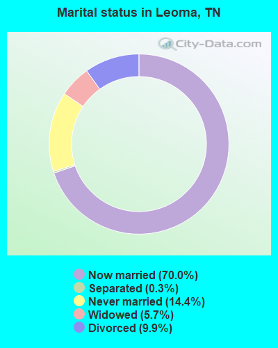
- Never married: 14.4%
- Now married: 70.0%
- Separated: 0.3%
- Widowed: 5.7%
- Divorced: 9.9%
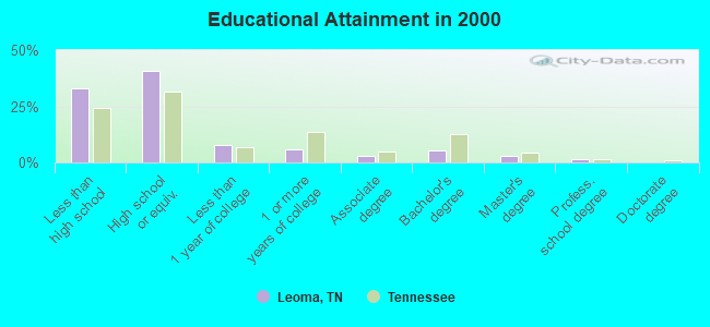
For population 25 years and over in Leoma:
- High school or higher: 66.8%
- Bachelor's degree or higher: 9.6%
- Graduate or professional degree: 4.0%
- Unemployed: 5.2%
- Mean travel time to work (commute): 25.7 minutes
| Here: | 12.8 |
| Tennessee average: | 13.3 |
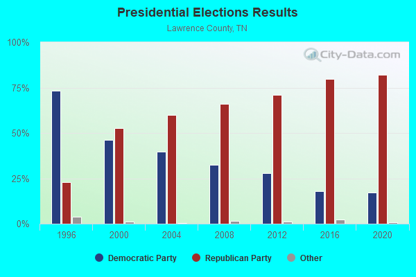
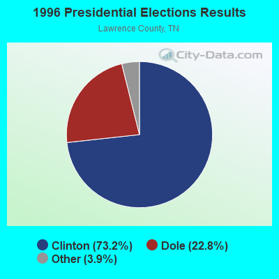
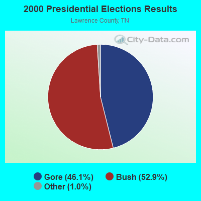

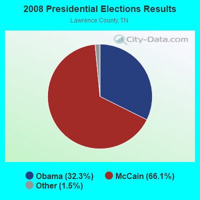
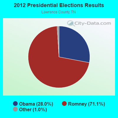
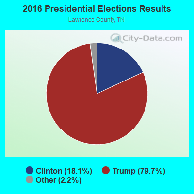
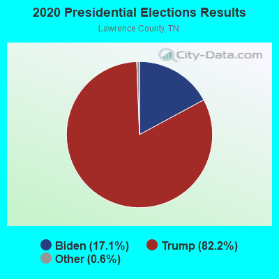
Graphs represent county-level data. Detailed 2008 Election Results
Religion statistics for Leoma, TN (based on Lawrence County data)
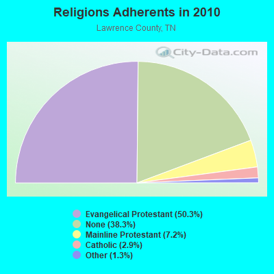
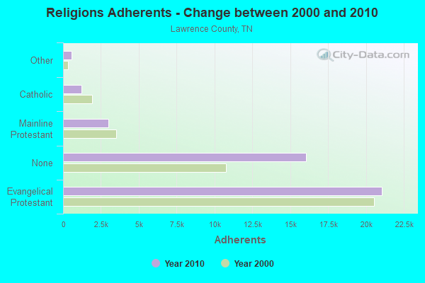
| Religion | Adherents | Congregations |
|---|---|---|
| Evangelical Protestant | 21,055 | 106 |
| Mainline Protestant | 3,005 | 21 |
| Catholic | 1,200 | 3 |
| Other | 563 | 2 |
| None | 16,046 | - |
Food Environment Statistics:
| Lawrence County: | 2.20 / 10,000 pop. |
| Tennessee: | 1.99 / 10,000 pop. |
| Here: | 0.24 / 10,000 pop. |
| State: | 0.17 / 10,000 pop. |
| Here: | 1.71 / 10,000 pop. |
| Tennessee: | 0.65 / 10,000 pop. |
| Here: | 7.58 / 10,000 pop. |
| Tennessee: | 5.16 / 10,000 pop. |
| This county: | 4.65 / 10,000 pop. |
| State: | 6.56 / 10,000 pop. |
| Lawrence County: | 13.0% |
| State: | 11.4% |
| Here: | 30.3% |
| Tennessee: | 30.2% |
| Here: | 11.9% |
| Tennessee: | 13.5% |
Businesses in Leoma, TN
- Kincaid: 1
- Lane Furniture: 1
- U-Haul: 1
Strongest AM radio stations in Leoma:
- WWLX (590 AM; 1 kW; LAWRENCEBURG, TN; Owner: PROSPECT COMMUNICATIONS)
- WZNN (620 AM; 5 kW; LEXINGTON, AL; Owner: MANUEL HUERTA)
- WSM (650 AM; 50 kW; NASHVILLE, TN; Owner: GAYLORD ENTERTAINMENT COMPANY)
- WLOR (1550 AM; 50 kW; HUNTSVILLE, AL; Owner: BCA RADIO, LLC)
- WVNN (770 AM; 10 kW; ATHENS, AL; Owner: ATHENS BROADCASTING COMPANY, INC.)
- WDXE (1370 AM; 1 kW; LAWRENCEBURG, TN; Owner: LAKEWOOD COMMUNICATIONS LLC)
- WBXR (1140 AM; daytime; 15 kW; HAZEL GREEN, AL; Owner: LOW COUNTRY CORPORATION, INC.)
- WAMB (1160 AM; 50 kW; DONELSON, TN; Owner: GREAT SOUTHERN BROADCASTING COMPANY, INC.)
- WKDA (1200 AM; 50 kW; NASHVILLE, TN; Owner: RADIO NASHVILLE, INC.)
- WWAM (820 AM; daytime; 50 kW; JASPER, TN; Owner: SHELTON BROADCASTING SYSTEM)
- WNQM (1300 AM; 50 kW; NASHVILLE, TN; Owner: WNQM. INC.)
- WKAC (1080 AM; daytime; 5 kW; ATHENS, AL; Owner: LIMESTONE BROADCASTING COMPANY, INC.)
- WDJL (1000 AM; daytime; 10 kW; HUNTSVILLE, AL; Owner: JAMES K. SHARP DBA 5TH AVE BROADCASTING)
Strongest FM radio stations in Leoma:
- WEUZ (92.1 FM; MINOR HILL, TN; Owner: BROADCAST ONE, INC.)
- WLLX (97.5 FM; LAWRENCEBURG, TN; Owner: ROGER WRIGHT DBA PROSPECT COMMUNICATIONS)
- W287AA (105.3 FM; LAWRENCEBURG, TN; Owner: WAY-FM MEDIA GROUP, INC.)
- WDXE-FM (106.7 FM; LAWRENCEBURG, TN; Owner: LAKEWOOD COMMUNICATIONS LLC)
- WKSR-FM (98.3 FM; PULASKI, TN; Owner: PULASKI BROADCASTING, INC.)
- WJOR-FM (101.5 FM; ST. JOSEPH, TN; Owner: CLEAR CHANNEL BROADCASTING LICENSES, INC.)
- W226AF (93.1 FM; LORETTO, TN; Owner: PROSPECT COMMUNICATIONS)
- WAHR (99.1 FM; HUNTSVILLE, AL; Owner: BCA RADIO, LLC)
- WYTK (93.9 FM; ROGERSVILLE, AL; Owner: SHOALS BROADCASTING CORPORATION)
- WLAY-FM (100.3 FM; TUSCUMBIA, AL; Owner: CLEAR CHANNEL BROADCASTING LICENSES, INC.)
- WAWI (89.7 FM; LAWRENCEBURG, TN; Owner: AMERICAN FAMILY ASSOCIATION)
- WZYP (104.3 FM; ATHENS, AL; Owner: ATHENS BROADCASTING COMPANY, INC.)
- W278AA (103.5 FM; MADISON, AL; Owner: TENNESSEE VALLEY RADIO, INC.)
- WDRM (102.1 FM; DECATUR, AL; Owner: CAPSTAR TX LIMITED PARTNERSHIP)
- W254AA (98.7 FM; COLBERT HEIGHTS, AL; Owner: WILLIAM P. ROGERS)
- WQLT-FM (107.3 FM; FLORENCE, AL; Owner: BIG RIVER BROADCASTING CORPORATION)
- W263AR (100.5 FM; LAWRENCEBURG, TN; Owner: PROSPECT COMMUNICATIONS)
- WMSR-FM (94.9 FM; COLLINWOOD, TN; Owner: OHIO BROADCAST ASSOCIATES)
- WFIX (91.3 FM; FLORENCE, AL; Owner: TRI-STATE INSPIRATIONAL B/C CORP.)
- W265AQ (100.9 FM; PULASKI, TN; Owner: WILLIAM S. GEORGE)
TV broadcast stations around Leoma:
- WHDF (Channel 15; FLORENCE, AL; Owner: VALLEY TELEVISION, LLC)
- WTZT-LP (Channel 11; ATHENS, AL; Owner: WTZT-LP TELEVISION STATION, L.L.C.)
- W10BV (Channel 10; LAWRENCEBURG, TN; Owner: ETC COMMUNICATIONS INC.)
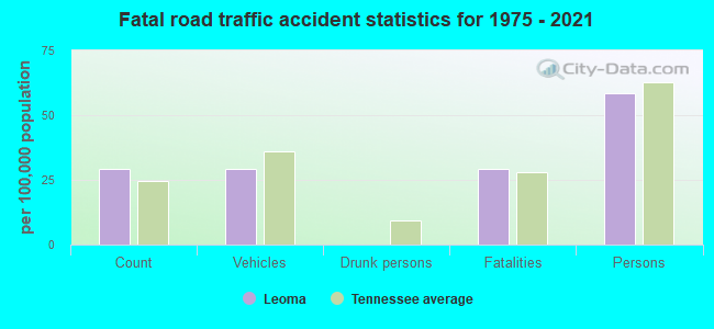
Leoma fatal accident list:
FCC Registered Cell Phone Towers:
1 (See the full list of FCC Registered Cell Phone Towers in Leoma)FCC Registered Antenna Towers:
22 (See the full list of FCC Registered Antenna Towers)FCC Registered Broadcast Land Mobile Towers:
1- Lat: 35.203333 Lon: -87.327500, Call Sign: WRKS412,
Assigned Frequencies: 159.735 MHz, 173.300 MHz, Grant Date: 02/05/2021, Expiration Date: 02/05/2031, Certifier: Roger Wright, Registrant: Prospect Communications, 156, Lawrenceville, TN 38464, Phone: (931) 629-7713, Email:
FCC Registered Microwave Towers:
11 (See the full list of FCC Registered Microwave Towers in this town)FCC Registered Amateur Radio Licenses:
36 (See the full list of FCC Registered Amateur Radio Licenses in Leoma)FAA Registered Aircraft:
4- Aircraft: CESSNA U206G (Category: Land, Seats: 6, Weight: Up to 12,499 Pounds, Speed: 132 mph), Engine: Reciprocating
N-Number: 206GB, N206GB, N-206GB, Serial Number: U206-05738, Certificate Issue Date: 05/01/2001
Registrant (Individual): Michael A Boyd, Po Box 40, Leoma, TN 38468
Deregistered: Cancel Date: 12/05/1980 - Aircraft: THERRIEN ROGER N JR VORTEX (Category: Land, Weight: Up to 12,499 Pounds), Engine: BOMBARDIER ROTAX (ALL) (Reciprocating)
N-Number: 42923, N42923, N-42923, Serial Number: 066, Year manufactured: 2005, Airworthiness Date: 06/10/2005, Certificate Issue Date: 05/26/2005
Registrant (Individual): Roger N Jr Therrien, 84 Horseshoe Bend Rd, Leoma, TN 38468 - Aircraft: BRITISH AEROSPACE BAE JETSTREAM 3201 (Category: Land, Engines: 2, Seats: 19, Weight: 12,500 - 19,999 Pounds), Engine: AIRESEARCH TPE331 SERIES (904 HP) (Turbo-prop)
N-Number: 872AE, N872AE, N-872AE, Serial Number: 872, Year manufactured: 1989, Airworthiness Date: 02/07/1990, Certificate Issue Date: 09/01/2006
Registrant (Corporation): Aircraft Leasing Corp, 2409 Highway 43 S, Leoma, TN 38468
Deregistered: Cancel Date: 07/12/2017 - Aircraft: BRITISH AEROSPACE BAE JETSTREAM 3201 (Category: Land, Engines: 2, Seats: 19, Weight: 12,500 - 19,999 Pounds), Engine: AIRESEARCH TPE331 SERIES (904 HP) (Turbo-prop)
N-Number: 880TE, N880TE, N-880TE, Serial Number: 880, Year manufactured: 1989, Airworthiness Date: 03/23/1990, Certificate Issue Date: 09/11/2006
Registrant (Corporation): Aircraft Leasing Corp, 2409 Highway 43 S, Leoma, TN 38468
Deregistered: Cancel Date: 07/07/2017
2002 - 2018 National Fire Incident Reporting System (NFIRS) incidents
- Fire incident types reported to NFIRS in Leoma, TN
- 43644.5%Outside Fires
- 40441.3%Structure Fires
- 929.4%Mobile Property/Vehicle Fires
- 474.8%Other
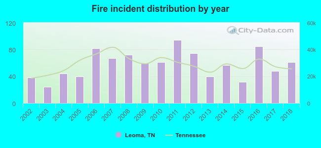 According to the data from the years 2002 - 2018 the average number of fire incidents per year is 58. The highest number of reported fires - 94 took place in 2011, and the least - 24 in 2003. The data has an increasing trend.
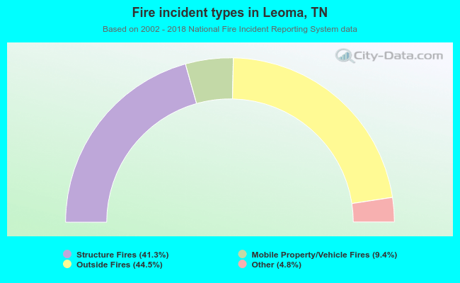 When looking into fire subcategories, the most reports belonged to: Outside Fires (44.5%), and Structure Fires (41.3%).
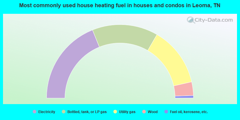
- 37.8%Electricity
- 29.0%Bottled, tank, or LP gas
- 26.1%Utility gas
- 6.0%Wood
- 1.1%Fuel oil, kerosene, etc.
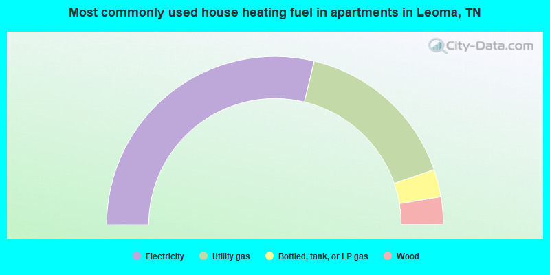
- 57.5%Electricity
- 31.9%Utility gas
- 5.3%Bottled, tank, or LP gas
- 5.3%Wood
Leoma compared to Tennessee state average:
- Unemployed percentage below state average.
- Black race population percentage significantly below state average.
- Hispanic race population percentage significantly below state average.
- Foreign-born population percentage significantly below state average.
- Renting percentage significantly below state average.
- Length of stay since moving in significantly above state average.
- Number of rooms per house significantly below state average.
- House age significantly below state average.
- Number of college students below state average.
- Percentage of population with a bachelor's degree or higher below state average.

|
Total of 5 patent applications in 2008-2024.