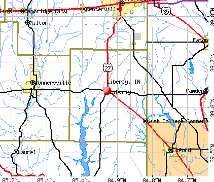
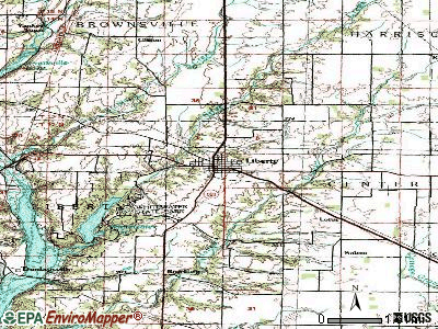
Liberty, Indiana

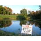
Liberty: W Retherford Road, Liberty, IN

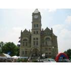
Liberty: Union County Courthouse, Liberty, IN
Liberty: Liberty Country Club
Liberty: Liberty Parade
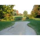
Liberty: Liberty Country Club
- add
your
Submit your own pictures of this town and show them to the world
- OSM Map
- General Map
- Google Map
- MSN Map
Population change since 2000: -2.8%
 |
| Males: 980 | |
| Females: 1,023 |
| Median resident age: | 46.2 years |
| Indiana median age: | 38.2 years |
Zip codes: 47353.
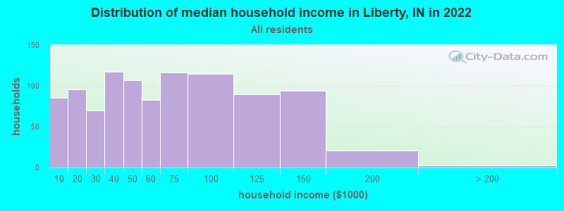
| Liberty: | $57,420 |
| IN: | $66,785 |
Estimated per capita income in 2022: $30,377 (it was $15,440 in 2000)
Liberty town income, earnings, and wages data
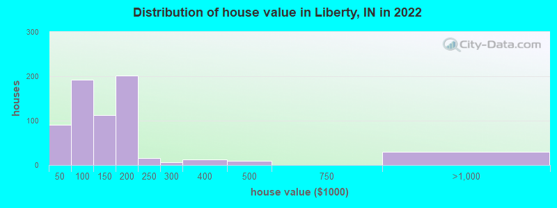
Estimated median house or condo value in 2022: $137,883 (it was $67,800 in 2000)
| Liberty: | $137,883 |
| IN: | $208,700 |
Mean prices in 2022: all housing units: $160,374; detached houses: $152,992; mobile homes: $226,546
Median gross rent in 2022: $744.
Detailed information about poverty and poor residents in Liberty, IN
Compare current foreclosures near Liberty, IN:
| Photo | Address | Area | Beds / Baths | Price | Details |
|---|---|---|---|---|---|

|
#1
Quail Run Ct
Liberty, IN 47353
|
2,212 sq. feet
|
2 baths 3 beds |
show details | |

|
#2
W Union St
Liberty, IN 47353
|
1,920 sq. feet
|
1 baths 2 beds |
show details | |

|
#3
W Fosdick Rd
Liberty, IN 47353
|
1,599 sq. feet
|
1 baths 3 beds |
show details | |

|
#4
N Brownsville Rd
Liberty, IN 47353
|
2,240 sq. feet
|
1 baths 4 beds |
show details | |

|
#5
N Market St
Liberty, IN 47353
|
- sq. feet
|
2 baths 3 beds |
show details | |

|
#6
S Main St
Liberty, IN 47353
|
- sq. feet
|
- baths - beds |
show details | |

|
#7
W Dunlapsville Rd
Liberty, IN 47353
|
- sq. feet
|
- baths - beds |
show details | |

|
#8
S A St
Richmond, IN 47374
|
976 sq. feet
|
1 baths 3 beds |
$119,900
|
show details |

|
#9
W 11th St
Connersville, IN 47331
|
1,560 sq. feet
|
1 baths 3 beds |
$26,500
|
show details |

|
#10
S Us Highway 27
Liberty, IN 47353
|
- sq. feet
|
- baths - beds |
show details |
| Photo | Address | Area | Beds / Baths | Price | Details |
|---|---|---|---|---|---|

|
#11
S State Road 101
Liberty, IN 47353
|
- sq. feet
|
- baths - beds |
show details | |

|
#12
S Treaty Line Rd
Liberty, IN 47353
|
- sq. feet
|
- baths - beds |
show details | |

|
#13
S 10th St
Richmond, IN 47374
|
1,154 sq. feet
|
1 baths 3 beds |
$24,900
|
show details |

|
#14
N 20th St
Richmond, IN 47374
|
1,372 sq. feet
|
1 baths 3 beds |
show details | |

|
#15
Vermont Ave
Connersville, IN 47331
|
812 sq. feet
|
1 baths 2 beds |
show details | |

|
#16
Pearl St
Richmond, IN 47374
|
1,352 sq. feet
|
1 baths 2 beds |
show details | |

|
#17
Oxford Germantown Rd
Camden, OH 45311
|
798 sq. feet
|
1 baths 3 beds |
show details | |

|
#18
Canyon Pkwy
Connersville, IN 47331
|
977 sq. feet
|
1 baths 2 beds |
show details | |

|
#19
S Spring St
New Paris, OH 45347
|
1,807 sq. feet
|
1 baths 3 beds |
show details | |

|
#20
S Main St
Somerville, OH 45064
|
2,120 sq. feet
|
1 baths 4 beds |
show details |
| Photo | Address | Area | Beds / Baths | Price | Details |
|---|---|---|---|---|---|

|
#21
Dana Dr
Oxford, OH 45056
|
1,765 sq. feet
|
1 baths 3 beds |
show details | |

|
#22
College Corner Rd
Richmond, IN 47374
|
1,472 sq. feet
|
1 baths 3 beds |
show details | |

|
#23
S 10th St
Richmond, IN 47374
|
2,108 sq. feet
|
1 baths 2 beds |
show details | |

|
#24
Cartwright Dr
Richmond, IN 47374
|
1,500 sq. feet
|
1 baths 3 beds |
show details | |

|
#25
E South St
Centerville, IN 47330
|
1,400 sq. feet
|
2 baths 3 beds |
show details | |

|
#26
Kinsey St
Richmond, IN 47374
|
2,088 sq. feet
|
2 baths 4 beds |
show details | |

|
#27
S 7th St
Richmond, IN 47374
|
1,974 sq. feet
|
1 baths 3 beds |
show details | |

|
#28
S 20th St
Richmond, IN 47374
|
1,432 sq. feet
|
1 baths 3 beds |
show details | |

|
#29
NW 18th St
Richmond, IN 47374
|
781 sq. feet
|
1 baths 2 beds |
show details | |

|
#30
W Main St
Richmond, IN 47374
|
930 sq. feet
|
1 baths 2 beds |
show details |
| Photo | Address | Area | Beds / Baths | Price | Details |
|---|---|---|---|---|---|

|
#31
S 12th St
Richmond, IN 47374
|
2,080 sq. feet
|
2 baths 3 beds |
show details | |

|
#32
SW 4th St
Richmond, IN 47374
|
792 sq. feet
|
1 baths 2 beds |
show details | |

|
#33
E Plum St
Centerville, IN 47330
|
1,654 sq. feet
|
2 baths 3 beds |
show details | |

|
#34
Longman Rd
Eaton, OH 45320
|
1,325 sq. feet
|
1 baths 3 beds |
show details | |

|
#35
SW 1st St
Richmond, IN 47374
|
2,416 sq. feet
|
1 baths 2 beds |
show details | |

|
#36
S 19th St
Richmond, IN 47374
|
2,056 sq. feet
|
2 baths 5 beds |
show details | |

|
#37
Southeast Pkwy
Richmond, IN 47374
|
2,238 sq. feet
|
2 baths 4 beds |
show details | |

|
#38
NW 6th St
Richmond, IN 47374
|
924 sq. feet
|
2 baths 3 beds |
show details | |

|
#39
Pinehurst Dr
Richmond, IN 47374
|
1,552 sq. feet
|
2 baths 3 beds |
show details | |

|
#40
W Us Highway 40
Cambridge City, IN 47327
|
1,584 sq. feet
|
1 baths 2 beds |
show details |
| Photo | Address | Area | Beds / Baths | Price | Details |
|---|---|---|---|---|---|

|
#41
Somerville Rd
Somerville, OH 45064
|
1,686 sq. feet
|
2 baths 3 beds |
show details | |

|
#42
Camden Rd
Eaton, OH 45320
|
1,520 sq. feet
|
1 baths 3 beds |
show details | |

|
#43
Crawfordsville Campbellst Rd
Eaton, OH 45320
|
1,647 sq. feet
|
1 baths 3 beds |
show details | |

|
#44
Flatley Rd
Richmond, IN 47374
|
1,200 sq. feet
|
1 baths 2 beds |
show details | |

|
#45
N County Road 400 W
Connersville, IN 47331
|
1,285 sq. feet
|
1 baths 3 beds |
show details | |

|
#46
N Centerville Rd
Centerville, IN 47330
|
1,248 sq. feet
|
1 baths 3 beds |
show details | |

|
#47
S Main St
Camden, OH 45311
|
1,648 sq. feet
|
2 baths 3 beds |
show details | |

|
#48
S County Road 350 W
Connersville, IN 47331
|
1,008 sq. feet
|
1 baths 3 beds |
show details | |

|
#49
W Galaxy Dr
Connersville, IN 47331
|
1,008 sq. feet
|
1 baths 3 beds |
show details | |

|
Check over 1 million property listings on Foreclosure.com!
|
browse all offers | |||


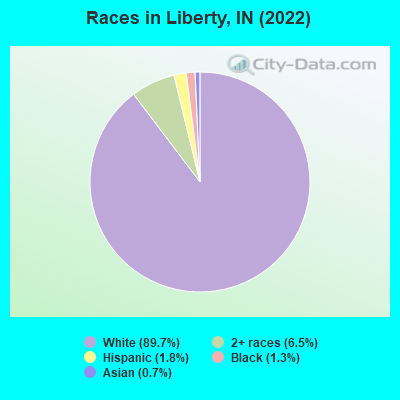
- 1,88289.7%White alone
- 1376.5%Two or more races
- 371.8%Hispanic
- 281.3%Black alone
- 140.7%Asian alone
Races in Liberty detailed stats: ancestries, foreign born residents, place of birth
According to our research of Indiana and other state lists, there was 1 registered sex offender living in Liberty, Indiana as of April 25, 2024.
The ratio of all residents to sex offenders in Liberty is 1,909 to 1.
The ratio of registered sex offenders to all residents in this city is much lower than the state average.
 Recent articles from our blog. Our writers, many of them Ph.D. graduates or candidates, create easy-to-read articles on a wide variety of topics.

 | Commuting from Louisville to Indy (227 replies) |
| Neighborhoods on the north side with trail access (3 replies) |
| Guitar Players (1 reply) |
| Questions about Liberty Creek (4 replies) |
| Gone but not forgotten in Indianapolis (277 replies) |
| Roads (85 replies) |
Latest news from Liberty, IN collected exclusively by city-data.com from local newspapers, TV, and radio stations
Ancestries: American (30.6%), German (26.0%), English (7.6%), Italian (4.5%), European (2.5%), Irish (2.5%).
Current Local Time: EST time zone
Elevation: 992 feet
Land area: 0.87 square miles.
Population density: 2,300 people per square mile (low).
54 residents are foreign born (1.7% Latin America, 0.7% Asia).
| This town: | 2.6% |
| Indiana: | 5.6% |
Median real estate property taxes paid for housing units with mortgages in 2022: $903 (0.6%)
Median real estate property taxes paid for housing units with no mortgage in 2022: $674 (0.6%)
Nearest city with pop. 50,000+: Hamilton, OH  (25.6 miles , pop. 60,690).
Nearest city with pop. 200,000+: Cincinnati, OH (41.4 miles , pop. 331,285).
Nearest city with pop. 1,000,000+: Chicago, IL (209.8 miles , pop. 2,896,016).
Nearest cities:
), ), ), ), Latitude: 39.64 N, Longitude: 84.93 W
Area code: 765
| Here: | 2.4% |
| Indiana: | 2.8% |
- Accommodation & food services (7.6%)
- Educational services (7.1%)
- Health care (5.3%)
- Finance & insurance (5.3%)
- Construction (4.9%)
- Public administration (4.8%)
- Social assistance (4.5%)
- Construction (9.8%)
- Public administration (6.7%)
- Truck transportation (6.3%)
- Furniture & related product manufacturing (6.1%)
- Transportation equipment (6.1%)
- Accommodation & food services (5.0%)
- Repair & maintenance (4.8%)

- Health care (10.6%)
- Educational services (10.1%)
- Accommodation & food services (10.1%)
- Finance & insurance (8.8%)
- Social assistance (8.2%)
- Food & beverage stores (6.2%)
- Religious, grantmaking, civic, professional, similar organizations (5.4%)
- Preschool, kindergarten, elementary, and middle school teachers (4.5%)
- Material recording, scheduling, dispatching, and distributing workers (4.4%)
- Other production occupations, including supervisors (4.4%)
- Electrical equipment mechanics and other installation, maintenance, and repair workers, including supervisors (4.2%)
- Driver/sales workers and truck drivers (3.7%)
- Building and grounds cleaning and maintenance occupations (3.6%)
- Retail sales workers, except cashiers (3.6%)
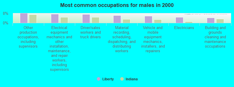
- Other production occupations, including supervisors (8.0%)
- Electrical equipment mechanics and other installation, maintenance, and repair workers, including supervisors (7.6%)
- Driver/sales workers and truck drivers (7.4%)
- Material recording, scheduling, dispatching, and distributing workers (6.3%)
- Vehicle and mobile equipment mechanics, installers, and repairers (5.9%)
- Electricians (4.8%)
- Building and grounds cleaning and maintenance occupations (4.3%)
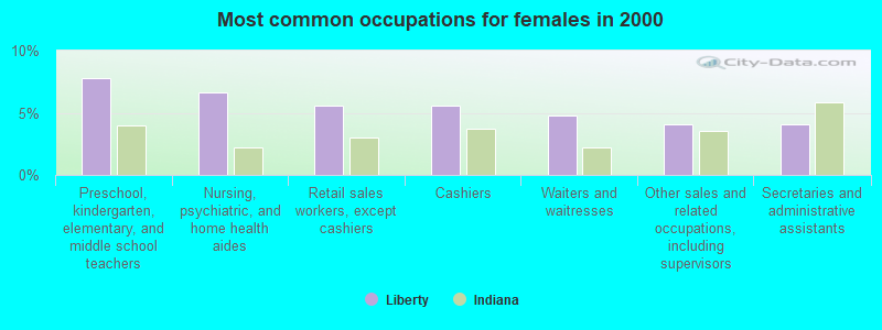
- Preschool, kindergarten, elementary, and middle school teachers (7.8%)
- Nursing, psychiatric, and home health aides (6.7%)
- Retail sales workers, except cashiers (5.6%)
- Cashiers (5.6%)
- Waiters and waitresses (4.7%)
- Other sales and related occupations, including supervisors (4.1%)
- Secretaries and administrative assistants (4.1%)
Average climate in Liberty, Indiana
Based on data reported by over 4,000 weather stations


|
|


(lower is better)
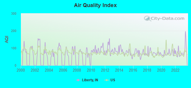
Air Quality Index (AQI) level in 2023 was 96.5. This is worse than average.
| City: | 96.5 |
| U.S.: | 72.6 |
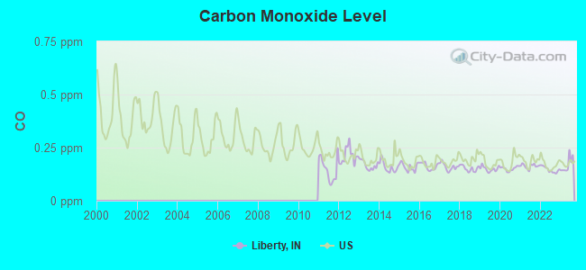
Carbon Monoxide (CO) [ppm] level in 2023 was 0.169. This is significantly better than average. Closest monitor was 17.7 miles away from the city center.
| City: | 0.169 |
| U.S.: | 0.251 |
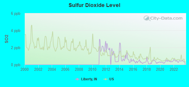
Sulfur Dioxide (SO2) [ppb] level in 2023 was 0.405. This is significantly better than average. Closest monitor was 12.5 miles away from the city center.
| City: | 0.405 |
| U.S.: | 1.515 |
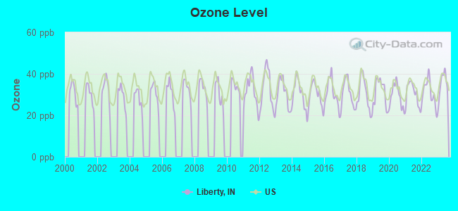
Ozone [ppb] level in 2023 was 34.6. This is about average. Closest monitor was 12.8 miles away from the city center.
| City: | 34.6 |
| U.S.: | 33.3 |
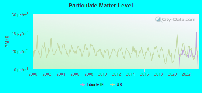
Particulate Matter (PM10) [µg/m3] level in 2023 was 19.2. This is about average. Closest monitor was 13.5 miles away from the city center.
| City: | 19.2 |
| U.S.: | 19.2 |
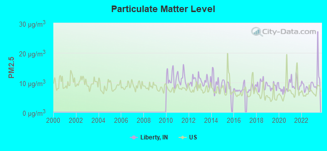
Particulate Matter (PM2.5) [µg/m3] level in 2023 was 11.7. This is significantly worse than average. Closest monitor was 17.7 miles away from the city center.
| City: | 11.7 |
| U.S.: | 8.1 |
Tornado activity:
Liberty-area historical tornado activity is near Indiana state average. It is 99% greater than the overall U.S. average.
On 4/3/1974, a category F5 (max. wind speeds 261-318 mph) tornado 32.9 miles away from the Liberty town center killed 3 people and injured 210 people.
On 4/3/1974, a category F4 (max. wind speeds 207-260 mph) tornado 17.6 miles away from the town center killed 4 people and injured 17 people and caused between $5,000,000 and $50,000,000 in damages.
Earthquake activity:
Liberty-area historical earthquake activity is significantly above Indiana state average. It is 48% greater than the overall U.S. average.On 7/27/1980 at 18:52:21, a magnitude 5.2 (5.1 MB, 4.7 MS, 5.0 UK, 5.2 UK, Class: Moderate, Intensity: VI - VII) earthquake occurred 112.3 miles away from the city center
On 4/18/2008 at 09:36:59, a magnitude 5.4 (5.1 MB, 4.8 MS, 5.4 MW, 5.2 MW) earthquake occurred 178.7 miles away from Liberty center
On 4/18/2008 at 09:36:59, a magnitude 5.2 (5.2 MW, Depth: 8.9 mi) earthquake occurred 178.7 miles away from the city center
On 6/10/1987 at 23:48:54, a magnitude 5.1 (4.9 MB, 4.4 MS, 4.6 MS, 5.1 LG) earthquake occurred 168.1 miles away from the city center
On 7/12/1986 at 08:19:37, a magnitude 4.5 (4.5 MB, Class: Light, Intensity: IV - V) earthquake occurred 69.0 miles away from Liberty center
On 6/18/2002 at 17:37:15, a magnitude 5.0 (4.3 MB, 4.6 MW, 5.0 LG) earthquake occurred 191.3 miles away from Liberty center
Magnitude types: regional Lg-wave magnitude (LG), body-wave magnitude (MB), surface-wave magnitude (MS), moment magnitude (MW)
Natural disasters:
The number of natural disasters in Union County (13) is near the US average (15).Major Disasters (Presidential) Declared: 10
Emergencies Declared: 2
Causes of natural disasters: Floods: 8, Storms: 7, Tornadoes: 4, Blizzard: 1, Hurricane: 1, Ice Storm: 1, Snow: 1, Winter Storm: 1, Other: 1 (Note: some incidents may be assigned to more than one category).
Hospitals and medical centers in Liberty:
Airports located in Liberty:
- Norris Field Airport (8II2) (Runways: 1)
Colleges/universities with over 2000 students nearest to Liberty:
- Miami University-Oxford (about 14 miles; Oxford, OH; Full-time enrollment: 17,670)
- Indiana University-East (about 17 miles; Richmond, IN; FT enrollment: 2,867)
- Miami University-Hamilton (about 27 miles; Hamilton, OH; FT enrollment: 2,906)
- Cincinnati State Technical and Community College (about 40 miles; Cincinnati, OH; FT enrollment: 8,757)
- Sinclair Community College (about 40 miles; Dayton, OH; FT enrollment: 13,779)
- University of Cincinnati-Blue Ash College (about 40 miles; Blue Ash, OH; FT enrollment: 3,711)
- College of Mount St Joseph (about 41 miles; Cincinnati, OH; FT enrollment: 2,073)
Public high school in Liberty:
- UNION COUNTY HIGH SCHOOL (Students: 502, Location: 410 E PATRIOT BLVD, Grades: 9-12)
Public elementary/middle schools in Liberty:
- UNION COUNTY MIDDLE SCHOOL (Students: 392, Location: 488 SR 44 E, Grades: 6-8)
- LIBERTY ELEMENTARY SCHOOL (Location: 501 EATON ST, Grades: KG-5)
Points of interest:
Notable location: Liberty Volunteer Fire Department (A). Display/hide its location on the map
Cemetery: Drook Cemetery (1). Display/hide its location on the map
Hotel: Liberty Motel (303 North Main).
Court: Indiana State - License Branch-Auto- Liberty (1 East High Street).
Birthplace of: Ambrose Burnside - Union Army general.
Drinking water stations with addresses in Liberty that have no violations reported:
- LIBERTY WATER WORKS (Population served: 2,061, Primary Water Source Type: Groundwater)
| This town: | 2.5 people |
| Indiana: | 2.5 people |
| This town: | 67.1% |
| Whole state: | 66.9% |
| This town: | 7.2% |
| Whole state: | 6.9% |
Likely homosexual households (counted as self-reported same-sex unmarried-partner households)
- Lesbian couples: 0.2% of all households
- Gay men: 0.1% of all households
18 people in local jails and other municipal confinement facilities in 2010
53 people in nursing homes in 2000
13 people in local jails and other confinement facilities (including police lockups) in 2000
Banks with branches in Liberty (2011 data):
- MainSource Bank: Liberty Branch at 310 North Main Street, branch established on 1895/07/01. Info updated 2009/12/09: Bank assets: $2,729.1 mil, Deposits: $2,167.0 mil, headquarters in Greensburg, IN, positive income, 86 total offices, Holding Company: Mainsource Financial Group, Inc.
- West End Bank, S.B.: Liberty Branch at 207 North Main Street, branch established on 1893/01/01. Info updated 2008/01/08: Bank assets: $240.5 mil, Deposits: $194.7 mil, headquarters in Richmond, IN, positive income, 5 total offices
- First Merchants Bank National Association: Liberty Union County Branch at 107 W Union St, branch established on 1872/06/20. Info updated 2012/02/13: Bank assets: $4,154.9 mil, Deposits: $3,154.7 mil, headquarters in Muncie, IN, positive income, Commercial Lending Specialization, 89 total offices, Holding Company: First Merchants Corporation
For population 15 years and over in Liberty:
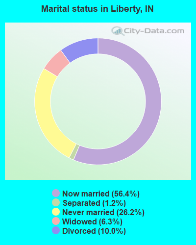
- Never married: 26.2%
- Now married: 56.4%
- Separated: 1.2%
- Widowed: 6.3%
- Divorced: 10.0%
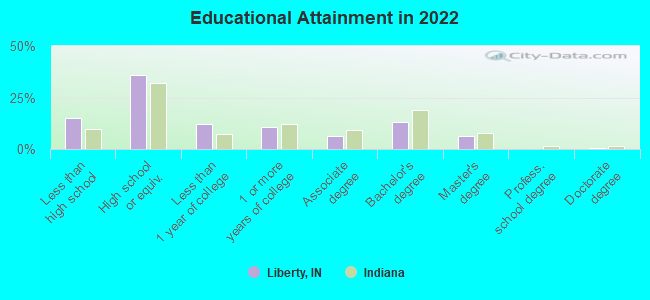
For population 25 years and over in Liberty:
- High school or higher: 84.3%
- Bachelor's degree or higher: 18.9%
- Graduate or professional degree: 6.6%
- Unemployed: 5.4%
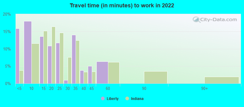
- Mean travel time to work (commute): 17.4 minutes
| Here: | 10.3 |
| Indiana average: | 11.3 |
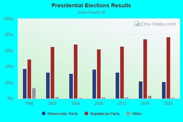
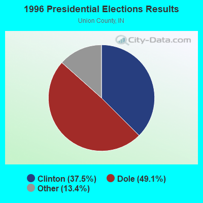

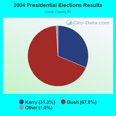
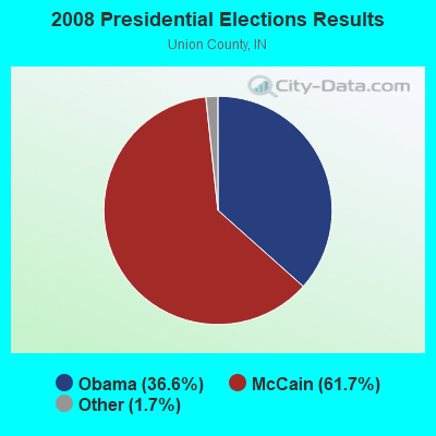
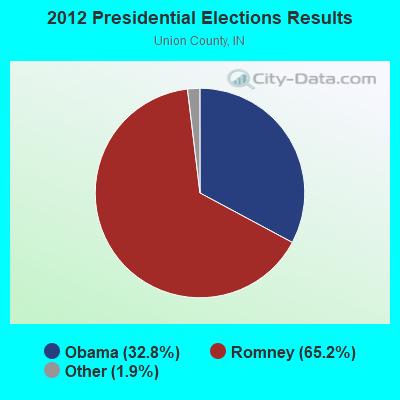
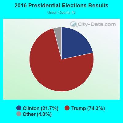
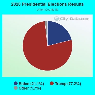
Graphs represent county-level data. Detailed 2008 Election Results
Religion statistics for Liberty, IN (based on Union County data)
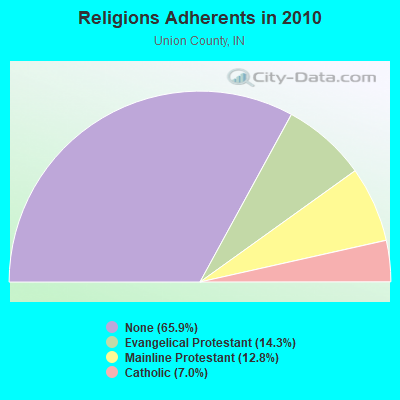
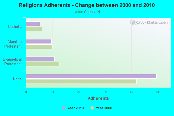
| Religion | Adherents | Congregations |
|---|---|---|
| Evangelical Protestant | 1,074 | 10 |
| Mainline Protestant | 964 | 6 |
| Catholic | 525 | 1 |
| Other | 1 | - |
| None | 4,952 | - |
Food Environment Statistics:
| Union County: | 1.39 / 10,000 pop. |
| Indiana: | 1.73 / 10,000 pop. |
| Union County: | 4.18 / 10,000 pop. |
| Indiana: | 0.50 / 10,000 pop. |
| This county: | 2.79 / 10,000 pop. |
| Indiana: | 3.57 / 10,000 pop. |
| Union County: | 1.39 / 10,000 pop. |
| State: | 6.78 / 10,000 pop. |
| Union County: | 9.3% |
| State: | 9.2% |
| Union County: | 29.0% |
| Indiana: | 29.0% |
| Union County: | 12.6% |
| State: | 14.3% |
Health and Nutrition:
| Liberty: | 61.3% |
| State: | 49.3% |
| Liberty: | 63.7% |
| Indiana: | 46.2% |
| Liberty: | 27.0 |
| Indiana: | 28.7 |
| Here: | 16.0% |
| State: | 21.3% |
| This city: | 5.9% |
| Indiana: | 10.6% |
| This city: | 7.1 |
| State: | 6.8 |
| This city: | 31.7% |
| State: | 33.9% |
| This city: | 67.5% |
| Indiana: | 56.1% |
| This city: | 82.2% |
| Indiana: | 78.7% |
More about Health and Nutrition of Liberty, IN Residents
| Local government employment and payroll (March 2022) | |||||
| Function | Full-time employees | Monthly full-time payroll | Average yearly full-time wage | Part-time employees | Monthly part-time payroll |
|---|---|---|---|---|---|
| Sewerage | 4 | $5,885 | $17,655 | 0 | $0 |
| Police Protection - Officers | 4 | $13,064 | $39,192 | 0 | $0 |
| Streets and Highways | 4 | $4,172 | $12,516 | 0 | $0 |
| Water Supply | 4 | $9,770 | $29,310 | 0 | $0 |
| Financial Administration | 2 | $4,065 | $24,390 | 0 | $0 |
| Other Government Administration | 1 | $2,872 | $34,464 | 5 | $2,010 |
| Police - Other | 0 | $0 | 3 | $1,935 | |
| Totals for Government | 19 | $39,828 | $25,155 | 8 | $3,945 |
Liberty government finances - Expenditure in 2021 (per resident):
- Current Operations - Sewerage: $322,000 ($160.76)
Police Protection: $201,000 ($100.35)
Financial Administration: $181,000 ($90.36)
Water Utilities: $86,000 ($42.94)
Regular Highways: $76,000 ($37.94)
Central Staff Services: $43,000 ($21.47)
Local Fire Protection: $36,000 ($17.97)
- Other Capital Outlay - Water Utilities: $38,000 ($18.97)
Sewerage: $27,000 ($13.48)
Local Fire Protection: $19,000 ($9.49)
Regular Highways: $7,000 ($3.49)
Police Protection: $2,000 ($1.00)
- Total Salaries and Wages: $470,000 ($234.65)
- Water Utilities - Interest on Debt: $122,000 ($60.91)
Liberty government finances - Revenue in 2021 (per resident):
- Charges - Sewerage: $800,000 ($399.40)
Solid Waste Management: $134,000 ($66.90)
- Local Intergovernmental - Highways: $107,000 ($53.42)
- Miscellaneous - General Revenue - Other: $70,000 ($34.95)
Interest Earnings: $21,000 ($10.48)
Rents: $1,000 ($0.50)
- Revenue - Water Utilities: $306,000 ($152.77)
- State Intergovernmental - Highways: $174,000 ($86.87)
General Local Government Support: $72,000 ($35.95)
- Tax - Property: $473,000 ($236.15)
Individual Income: $345,000 ($172.24)
Motor Vehicle License: $25,000 ($12.48)
Liberty government finances - Debt in 2021 (per resident):
- Long Term Debt - Beginning Outstanding - Unspecified Public Purpose: $3,060,000 ($1527.71)
Outstanding Unspecified Public Purpose: $2,692,000 ($1343.98)
Retired Unspecified Public Purpose: $368,000 ($183.72)
Liberty government finances - Cash and Securities in 2021 (per resident):
- Other Funds - Cash and Securities: $6,346,000 ($3168.25)
- Sinking Funds - Cash and Securities: $493,000 ($246.13)
| Businesses in Liberty, IN | ||||
| Name | Count | Name | Count | |
|---|---|---|---|---|
| Curves | 1 | Subway | 1 | |
| FedEx | 1 | U-Haul | 1 | |
Strongest AM radio stations in Liberty:
- WLW (700 AM; 50 kW; CINCINNATI, OH; Owner: JACOR BROADCASTING CORPORATION)
- WSAI (1530 AM; 50 kW; CINCINNATI, OH; Owner: JACOR BROADCASTING CORPORATION)
- WIBC (1070 AM; 50 kW; INDIANAPOLIS, IN; Owner: EMMIS RADIO LICENSE CORPORATION)
- WTVN (610 AM; 50 kW; COLUMBUS, OH; Owner: CITICASTERS LICENSES, L.P.)
- WHAS (840 AM; 50 kW; LOUISVILLE, KY; Owner: CLEAR CHANNEL BROADCASTING LICENSES, INC.)
- WOWO (1190 AM; 50 kW; FORT WAYNE, IN; Owner: PATHFINDER COMMUNICATIONS CORPORATION)
- WKBV (1490 AM; 1 kW; RICHMOND, IN; Owner: RODGERS BROADCASTING CORP.)
- WCNW (1560 AM; daytime; 5 kW; FAIRFIELD, OH)
- WKRC (550 AM; 5 kW; CINCINNATI, OH; Owner: JACOR BROADCASTING CORPORATION)
- WCKY (1360 AM; 5 kW; CINCINNATI, OH; Owner: JACOR BROADCASTING CORPORATION)
- WONE (980 AM; 5 kW; DAYTON, OH; Owner: CITICASTERS LICENSES, L.P.)
- WCIN (1480 AM; 5 kW; CINCINNATI, OH)
- WRFD (880 AM; daytime; 23 kW; COLUMBUS-WORTHINGTON, OH; Owner: SALEM MEDIA OF OHIO, INC.)
Strongest FM radio stations in Liberty:
- WMUB (88.5 FM; OXFORD, OH; Owner: THE PRES.& TRUSTEES OF MIAMI UNIV.)
- WFMG (101.3 FM; RICHMOND, IN; Owner: RODGERS BROADCASTING CORP.)
- WIFE (100.3 FM; CONNERSVILLE, IN; Owner: RODGERS BROADCASTING CORPORATION)
- WQLK (96.1 FM; RICHMOND, IN; Owner: BREWER BROADCASTING CORP.)
- WMOJ (94.9 FM; FAIRFIELD, OH; Owner: WVAE LICO, INC.)
- WOXY (97.7 FM; OXFORD, OH; Owner: BALOGH BROADCASTING COMPANY, INC.)
- WHKO (99.1 FM; DAYTON, OH; Owner: CXR HOLDINGS, INC.)
- WGRR (103.5 FM; HAMILTON, OH; Owner: INFINITY RADIO OPERATIONS INC.)
- WRRM (98.5 FM; CINCINNATI, OH; Owner: WRRM LICO, INC)
- WYGY (96.5 FM; LEBANON, OH; Owner: WVAE LICO, INC.)
- WUBE-FM (105.1 FM; CINCINNATI, OH; Owner: INFINITY RADIO OPERATIONS INC.)
- WOFX-FM (92.5 FM; CINCINNATI, OH; Owner: JACOR BROADCASTING CORPORATION)
- WGUC (90.9 FM; CINCINNATI, OH; Owner: CINCINNATI CLASSICAL PUBLIC RADIO, INC.)
- WKWH-FM (94.3 FM; RUSHVILLE, IN; Owner: RSE BROADCASTING, LLC)
- WPFB-FM (105.9 FM; MIDDLETOWN, OH; Owner: RADIO STATIONS WPAY/WPFB, INC.)
- WGTZ (92.9 FM; EATON, OH; Owner: BLUE CHIP BROADCASTING LICENSES, LTD)
- WNLT (104.3 FM; HARRISON, OH; Owner: VERNON R. BALDWIN, INC.)
- WHSS (89.5 FM; HAMILTON, OH; Owner: HAMILTON SCHOOL DISTRICT)
- WECI (91.5 FM; RICHMOND, IN; Owner: EARLHAM COLLEGE)
- WVXR (89.3 FM; RICHMOND, IN; Owner: XAVIER UNIVERSITY)
TV broadcast stations around Liberty:
- WPTO (Channel 14; OXFORD, OH; Owner: GREATER DAYTON PUBLIC TELEVISION, INC.)
- WKOI (Channel 43; RICHMOND, IN; Owner: TRINITY BROADCASTING OF INDIANA, INC.)
- WHIO-TV (Channel 7; DAYTON, OH; Owner: WHIO-TV HOLDINGS, INC.)
- WDTN (Channel 2; DAYTON, OH; Owner: WDTN BROADCASTING, LLC)
- WKEF (Channel 22; DAYTON, OH; Owner: WKEF LICENSEE L.P.)
- WRGT-TV (Channel 45; DAYTON, OH; Owner: WRGT LICENSEE, LLC)
- WPTD (Channel 16; DAYTON, OH; Owner: GREATER DAYTON PUBLIC TV, INC.)
- WLWT (Channel 5; CINCINNATI, OH; Owner: OHIO/OKLAHOMA HEARST-ARGYLE TV, INC)
- WXIX-TV (Channel 19; NEWPORT, KY; Owner: RAYCOM NATIONAL, INC.)
- WSTR-TV (Channel 64; CINCINNATI, OH; Owner: WSTR LICENSEE, INC.)
- WCET (Channel 48; CINCINNATI, OH; Owner: THE GREATER CINCINNATI TV EDUC'L. FOUNDATION)
- W61DE (Channel 61; CINCINNATI, OH; Owner: TRINITY BROADCASTING NETWORK)
- WKRC-TV (Channel 12; CINCINNATI, OH; Owner: CITICASTERS CO.)
- National Bridge Inventory (NBI) Statistics
- 17Number of bridges
- 194ft / 58.6mTotal length
- $500,000Total costs
- 23,995Total average daily traffic
- 2,000Total average daily truck traffic
- 33,365Total future (year 2030) average daily traffic
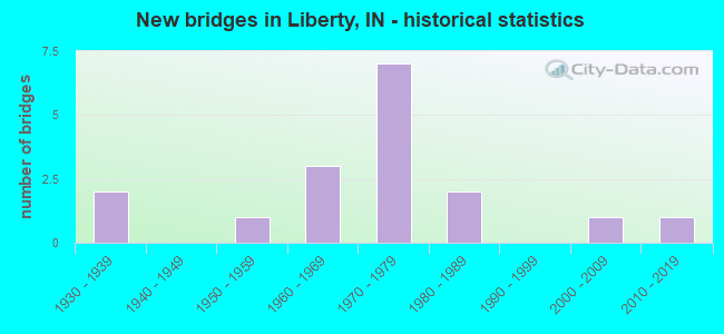
- New bridges - historical statistics
- 21930-1939
- 11950-1959
- 31960-1969
- 71970-1979
- 21980-1989
- 12000-2009
- 12010-2019
FCC Registered Cell Phone Towers:
1 (See the full list of FCC Registered Cell Phone Towers in Liberty)FCC Registered Antenna Towers:
43 (See the full list of FCC Registered Antenna Towers)FCC Registered Broadcast Land Mobile Towers:
8 (See the full list of FCC Registered Broadcast Land Mobile Towers in Liberty, IN)FCC Registered Microwave Towers:
5- LIBERTY, Off Old Sr 27 (Lat: 39.643972 Lon: -84.927000), Type: Tower, Structure height: 86.9 m, Overall height: 89.9 m, Call Sign: WQIG411,
Assigned Frequencies: 10835.0 MHz, 10995.0 MHz, 10995.0 MHz, 10995.0 MHz, 10995.0 MHz, 10995.0 MHz, 10995.0 MHz, 10995.0 MHz, 10995.0 MHz, Grant Date: 01/31/2018, Expiration Date: 01/31/2028, Certifier: James F Connor, Registrant: Intelpath, Hinsdale, IL 60522, Phone: (312) 841-9188, Email:
- MW07225A, 4724 Cartersburg Rd (Lat: 39.707028 Lon: -86.477333), Type: Mtower, Structure height: 57.9 m, Call Sign: WQVV991,
Assigned Frequencies: 19525.0 MHz, 19525.0 MHz, 19525.0 MHz, 19525.0 MHz, 19525.0 MHz, 19525.0 MHz, 19525.0 MHz, 19525.0 MHz, Grant Date: 05/26/2015, Expiration Date: 05/26/2025, Cancellation Date: 04/28/2023, Certifier: David Werblow, Registrant: T-Mobile Usa, Inc., 12920 Se 38th Street, Bellevue, WA 98006, Phone: (425) 383-8401, Fax: (425) 383-4040, Email:
- MW12464B, 674 U.S. 27 South (Liberty South, In # 304500) (Lat: 39.623444 Lon: -84.907056), Type: Ltower, Structure height: 85.3 m, Overall height: 88.7 m, Call Sign: WQWZ769,
Assigned Frequencies: 10775.0 MHz, 10775.0 MHz, 10775.0 MHz, 10775.0 MHz, 10775.0 MHz, 10775.0 MHz, 10775.0 MHz, 10775.0 MHz, Grant Date: 01/08/2016, Expiration Date: 01/08/2026, Certifier: David Werblow, Registrant: T-Mobile Usa, Inc., 12920 Se 38th Street, Bellevue, WA 98006, Phone: (425) 383-8401, Fax: (425) 383-4040, Email:
- LIBERTY, 3871 Us 27 South (Lat: 39.573667 Lon: -84.826139), Type: Ltower, Structure height: 87.8 m, Overall height: 90.8 m, Call Sign: WRQK214,
Assigned Frequencies: 11265.0 MHz, 11305.0 MHz, 11345.0 MHz, 11385.0 MHz, Grant Date: 04/29/2022, Expiration Date: 04/29/2032, Certifier: Cecil J Mathew, Registrant: At&t Services, Inc., 208 S Akard St, 20f, Dallas, TX 75202, Phone: (855) 699-7073, Email:
- CUS - LIBERTY, 1764 N Market Street (Lat: 39.643972 Lon: -84.927000), Type: Ltower, Structure height: 86.9 m, Overall height: 90.5 m, Call Sign: WRQK215,
Assigned Frequencies: 10775.0 MHz, 10815.0 MHz, 10855.0 MHz, 10895.0 MHz, Grant Date: 04/29/2022, Expiration Date: 04/29/2032, Certifier: Cecil J Mathew, Registrant: At&t Services, Inc., 208 S Akard St, 20f, Dallas, TX 75202, Phone: (855) 699-7073, Email:
FCC Registered Amateur Radio Licenses:
29 (See the full list of FCC Registered Amateur Radio Licenses in Liberty)FAA Registered Aircraft:
2- Aircraft: PIPER PA-22-150 (Category: Land, Seats: 4, Weight: Up to 12,499 Pounds, Speed: 94 mph), Engine: LYCOMING 0-320 SERIES (180 HP) (Reciprocating)
N-Number: 3524Z, N3524Z, N-3524Z, Serial Number: 22-7427, Year manufactured: 1960, Airworthiness Date: 06/10/1960, Certificate Issue Date: 05/08/2012
Registrant (Co-Owned): Robert S Rehmel, 1560 W Curry Rd, Liberty, IN 47353, Other Owners: Robert L Rehmel - Aircraft: NORRIS WAYNE C M2 (Category: Land, Seats: 2, Weight: Up to 12,499 Pounds), Engine: AMA/EXPR UNKNOWN ENG (Reciprocating)
N-Number: 51NF, N51NF, N-51NF, Serial Number: 2394, Year manufactured: 2011, Airworthiness Date: 07/06/2011, Certificate Issue Date: 06/06/2011
Registrant (Co-Owned): Wayne C Norris, 1382 N County Road 350 E, Liberty, IN 47353, Other Owners: Kathleen A Norris
2003 - 2018 National Fire Incident Reporting System (NFIRS) incidents
- Fire incident types reported to NFIRS in Liberty, IN
- 7644.7%Structure Fires
- 5029.4%Outside Fires
- 4023.5%Mobile Property/Vehicle Fires
- 42.4%Other
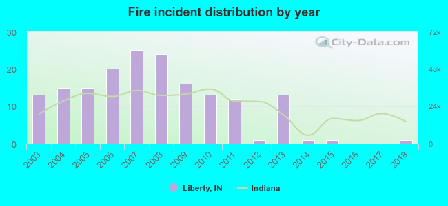 According to the data from the years 2003 - 2018 the average number of fire incidents per year is 11. The highest number of reported fire incidents - 25 took place in 2007, and the least - 0 in 2016. The data has a dropping trend.
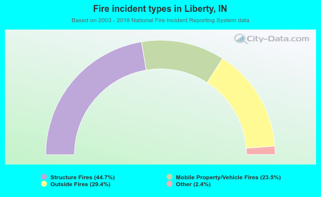 When looking into fire subcategories, the most incidents belonged to: Structure Fires (44.7%), and Outside Fires (29.4%).
| Most common first names in Liberty, IN among deceased individuals | ||
| Name | Count | Lived (average) |
|---|---|---|
| Mary | 57 | 80.9 years |
| James | 45 | 71.9 years |
| William | 36 | 72.6 years |
| Robert | 36 | 72.9 years |
| John | 34 | 74.2 years |
| Charles | 34 | 76.3 years |
| Joseph | 20 | 74.9 years |
| Ruth | 20 | 81.1 years |
| Dorothy | 20 | 81.1 years |
| George | 19 | 77.0 years |
| Most common last names in Liberty, IN among deceased individuals | ||
| Last name | Count | Lived (average) |
|---|---|---|
| Davis | 20 | 75.0 years |
| Stevens | 15 | 79.9 years |
| Fields | 15 | 80.2 years |
| Jones | 15 | 80.4 years |
| Miller | 14 | 74.5 years |
| Smith | 13 | 77.4 years |
| Hensley | 12 | 77.4 years |
| Johnson | 12 | 85.3 years |
| Brown | 11 | 75.2 years |
| Moore | 11 | 71.8 years |
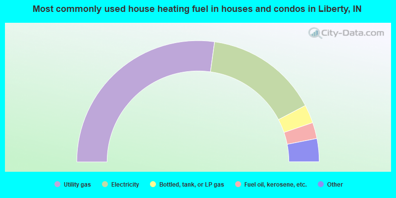
- 54.5%Utility gas
- 30.3%Electricity
- 4.9%Bottled, tank, or LP gas
- 4.3%Fuel oil, kerosene, etc.
- 3.4%Wood
- 2.5%Other fuel
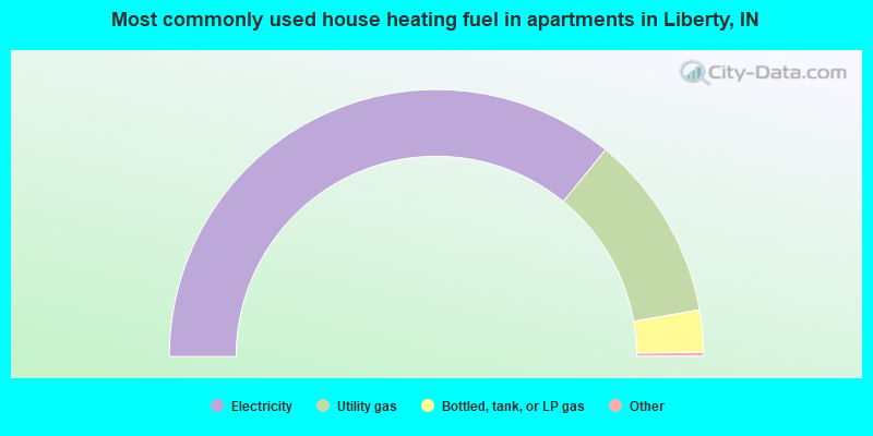
- 72.2%Electricity
- 22.7%Utility gas
- 5.1%Bottled, tank, or LP gas
Liberty compared to Indiana state average:
- Median house value below state average.
- Unemployed percentage below state average.
- Black race population percentage significantly below state average.
- Hispanic race population percentage significantly below state average.
- Median age below state average.
- Foreign-born population percentage below state average.
- Length of stay since moving in significantly above state average.
- Number of college students below state average.

|
Total of 5 patent applications in 2008-2024.