Merrimac, Massachusetts

Merrimac: clobers brook
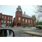
Merrimac
Merrimac: the food exit sign. all we had is a Dunkin Donuts which was added in 2003
- add
your
Submit your own pictures of this town and show them to the world
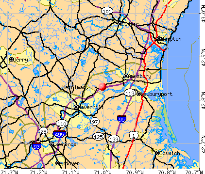
- OSM Map
- General Map
- Google Map
- MSN Map
Population change since 2000: +3.3%
 |
| Males: 3,057 | |
| Females: 3,281 |
| Median resident age: | 43.7 years |
| Massachusetts median age: | 39.2 years |
Zip codes: 01860.
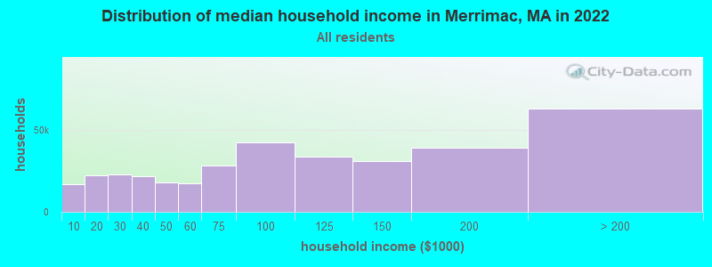
| Merrimac: | $105,163 |
| MA: | $94,488 |
Estimated per capita income in 2022: $48,351 (it was $24,869 in 2000)
Merrimac town income, earnings, and wages data
Estimated median house or condo value in 2022: $564,511 (it was $201,000 in 2000)
| Merrimac: | $564,511 |
| MA: | $534,700 |
Mean prices in 2022: all housing units: $645,471; detached houses: $712,185; townhouses or other attached units: $551,275; in 2-unit structures: $503,219; in 3-to-4-unit structures: $450,535; in 5-or-more-unit structures: $352,534; mobile homes: $123,118; occupied boats, rvs, vans, etc.: $131,058
Detailed information about poverty and poor residents in Merrimac, MA


Compare current foreclosures near Merrimac, MA:
| Photo | Address | Area | Beds / Baths | Price | Details |
|---|---|---|---|---|---|

|
#1
Bear Hill Rd
Merrimac, MA 01860
|
1,304 sq. feet
|
1 baths 3 beds |
show details | |

|
#2
W Main St Apt 214
Merrimac, MA 01860
|
- sq. feet
|
- baths - beds |
show details | |

|
#3
Cedar St # A
Haverhill, MA 01830
|
1,134 sq. feet
|
2 baths 2 beds |
$209,300
|
show details |

|
#4
Brentwood Rd
Exeter, NH 03833
|
2,756 sq. feet
|
2 baths 3 beds |
$419,900
|
show details |

|
#5
Shore Dr
Hampstead, NH 03841
|
787 sq. feet
|
1 baths 2 beds |
$529,900
|
show details |

|
#6
Frances Street Aka 57 Francis Street
Haverhill, MA 01830
|
1,280 sq. feet
|
2 baths 3 beds |
show details | |

|
#7
Windbrook Dr
Epping, NH 03042
|
1,680 sq. feet
|
1 baths 3 beds |
show details | |

|
#8
Hemlock Cir
Sandown, NH 03873
|
1,912 sq. feet
|
2 baths 4 beds |
show details | |

|
#9
Salem St
North Andover, MA 01845
|
1,572 sq. feet
|
1 baths 2 beds |
show details | |

|
#10
Beede Hill Rd
Fremont, NH 03044
|
1,135 sq. feet
|
1 baths 3 beds |
show details |
| Photo | Address | Area | Beds / Baths | Price | Details |
|---|---|---|---|---|---|

|
#11
Pine Ridge Rd
Windham, NH 03087
|
1,746 sq. feet
|
2 baths 4 beds |
show details | |

|
#12
Oak Ridge Rd
Plaistow, NH 03865
|
3,089 sq. feet
|
3 baths 5 beds |
show details | |

|
#13
S Broadway
Lawrence, MA 01843
|
5,706 sq. feet
|
2 baths 6 beds |
show details | |

|
#14
Brook St
Derry, NH 03038
|
1,476 sq. feet
|
2 baths 4 beds |
show details | |

|
#15
Phillips Cmn
North Andover, MA 01845
|
1,897 sq. feet
|
2 baths 3 beds |
show details | |

|
#16
Broadway, Apt 1
Methuen, MA 01844
|
2,328 sq. feet
|
4 baths 6 beds |
show details | |

|
#17
Mile Ln
Ipswich, MA 01938
|
2,240 sq. feet
|
2 baths 3 beds |
show details | |

|
#18
Parkview Ave
Salem, NH 03079
|
1,812 sq. feet
|
1 baths 3 beds |
show details | |

|
#19
Alexander Ave
Salem, NH 03079
|
1,149 sq. feet
|
1 baths 3 beds |
show details | |

|
#20
Lawrence St
Lawrence, MA 01841
|
4,206 sq. feet
|
3 baths 9 beds |
show details |
| Photo | Address | Area | Beds / Baths | Price | Details |
|---|---|---|---|---|---|

|
#21
Lawrence St
Lawrence, MA 01841
|
4,206 sq. feet
|
3 baths 9 beds |
show details | |

|
#22
Gage St
Methuen, MA 01844
|
3,197 sq. feet
|
2 baths 3 beds |
show details | |

|
#23
Marengo St # 4
North Andover, MA 01845
|
1,765 sq. feet
|
3 baths 2 beds |
show details | |

|
#24
Samoset Dr
Salem, NH 03079
|
4,816 sq. feet
|
3 baths 3 beds |
show details | |

|
#25
Dearborn Ave
Hampton, NH 03842
|
1,708 sq. feet
|
1 baths 3 beds |
show details | |

|
#26
Cluff Crossing Rd
Salem, NH 03079
|
1,120 sq. feet
|
2 baths 2 beds |
show details | |

|
#27
Chestnut St
North Andover, MA 01845
|
2,516 sq. feet
|
3 baths 4 beds |
show details | |

|
#28
Maclarnon Rd
Salem, NH 03079
|
2,020 sq. feet
|
1 baths 3 beds |
show details | |

|
#29
Webster St
Salem, NH 03079
|
1,912 sq. feet
|
2 baths 3 beds |
show details | |

|
#30
Atkinson St
Lawrence, MA 01843
|
825 sq. feet
|
2 baths 3 beds |
show details |
| Photo | Address | Area | Beds / Baths | Price | Details |
|---|---|---|---|---|---|

|
#31
Muse Ter
Salem, NH 03079
|
1,024 sq. feet
|
1 baths 3 beds |
show details | |

|
#32
Chester St # 1
Lawrence, MA 01843
|
4,935 sq. feet
|
3 baths 9 beds |
show details | |

|
#33
Brookfield St
Lawrence, MA 01843
|
2,878 sq. feet
|
2 baths 6 beds |
show details | |

|
#34
Hallenan Ave
Lawrence, MA 01841
|
1,564 sq. feet
|
1 baths 3 beds |
show details | |

|
#35
Kenwood St
Lawrence, MA 01841
|
2,526 sq. feet
|
3 baths 8 beds |
show details | |

|
#36
Beedle Ter
Methuen, MA 01844
|
1,507 sq. feet
|
2 baths 4 beds |
show details | |

|
#37
Scenic Dr
Derry, NH 03038
|
1,692 sq. feet
|
1 baths 2 beds |
show details | |

|
#38
Linebrook Rd
Ipswich, MA 01938
|
901 sq. feet
|
1 baths 1 beds |
show details | |

|
#39
Brentwood Rd
Exeter, NH 03833
|
3,683 sq. feet
|
3 baths 4 beds |
show details | |

|
#40
Golf Ave
Methuen, MA 01844
|
2,208 sq. feet
|
1 baths 3 beds |
show details |
| Photo | Address | Area | Beds / Baths | Price | Details |
|---|---|---|---|---|---|

|
#41
64th St
Newburyport, MA 01950
|
1,517 sq. feet
|
2 baths 2 beds |
show details | |

|
#42
Northern Blvd
Newburyport, MA 01950
|
805 sq. feet
|
1 baths 2 beds |
show details | |

|
#43
Lawrence Rd Un 22
Rowley, MA 01969
|
720 sq. feet
|
1 baths 1 beds |
show details | |

|
#44
Ernest Ave Apt 4
Exeter, NH 03833
|
555 sq. feet
|
1 baths 1 beds |
show details | |

|
#45
Riverview Blvd Apt 8-108
Methuen, MA 01844
|
1,303 sq. feet
|
2 baths 2 beds |
show details | |

|
#46
Hamilton Ln
Salem, NH 03079
|
2,818 sq. feet
|
2 baths 4 beds |
show details | |

|
#47
Greendale St
Methuen, MA 01844
|
1,777 sq. feet
|
1 baths 3 beds |
show details | |

|
#48
Harvard St
Exeter, NH 03833
|
1,509 sq. feet
|
1 baths 3 beds |
show details | |

|
#49
Marshall St
Methuen, MA 01844
|
840 sq. feet
|
1 baths 2 beds |
show details | |

|
Check over 1 million property listings on Foreclosure.com!
|
browse all offers | |||

- 6,06795.7%White alone
- 1151.8%Hispanic
- 681.1%Two or more races
- 360.6%Black alone
- 410.6%Asian alone
- 80.1%American Indian alone
- 30.05%Other race alone
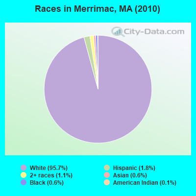
Races in Merrimac detailed stats: ancestries, foreign born residents, place of birth
According to our research of Massachusetts and other state lists, there were 5 registered sex offenders living in Merrimac, Massachusetts as of April 24, 2024.
The ratio of all residents to sex offenders in Merrimac is 1,268 to 1.
The ratio of registered sex offenders to all residents in this city is near the state average.
Type |
2009 |
2010 |
2011 |
2012 |
2013 |
2014 |
2015 |
2016 |
2017 |
2018 |
2019 |
2020 |
2021 |
2022 |
|---|---|---|---|---|---|---|---|---|---|---|---|---|---|---|
| Murders (per 100,000) | 0 (0.0) | 0 (0.0) | 0 (0.0) | 0 (0.0) | 0 (0.0) | 0 (0.0) | 0 (0.0) | 0 (0.0) | 0 (0.0) | 0 (0.0) | 0 (0.0) | 0 (0.0) | 0 (0.0) | 0 (0.0) |
| Rapes (per 100,000) | 2 (30.6) | 0 (0.0) | 1 (15.7) | 1 (15.5) | 0 (0.0) | 1 (14.9) | 1 (14.7) | 1 (14.6) | 2 (28.8) | 2 (28.6) | 0 (0.0) | 0 (0.0) | 3 (42.3) | 2 (29.7) |
| Robberies (per 100,000) | 1 (15.3) | 0 (0.0) | 0 (0.0) | 0 (0.0) | 1 (15.2) | 2 (29.9) | 0 (0.0) | 1 (14.6) | 0 (0.0) | 1 (14.3) | 0 (0.0) | 0 (0.0) | 0 (0.0) | 0 (0.0) |
| Assaults (per 100,000) | 8 (122.4) | 0 (0.0) | 7 (109.8) | 6 (93.1) | 10 (151.7) | 3 (44.8) | 2 (29.3) | 5 (72.9) | 0 (0.0) | 1 (14.3) | 2 (28.6) | 2 (28.6) | 3 (42.3) | 8 (118.9) |
| Burglaries (per 100,000) | 3 (45.9) | 12 (189.3) | 28 (439.1) | 19 (294.8) | 24 (364.2) | 12 (179.2) | 12 (176.0) | 11 (160.4) | 8 (115.1) | 10 (143.0) | 5 (71.4) | 1 (14.3) | 2 (28.2) | 3 (44.6) |
| Thefts (per 100,000) | 23 (351.8) | 19 (299.8) | 19 (297.9) | 37 (574.0) | 29 (440.1) | 30 (448.0) | 35 (513.3) | 26 (379.1) | 16 (230.3) | 15 (214.5) | 9 (128.6) | 11 (157.3) | 9 (126.9) | 16 (237.9) |
| Auto thefts (per 100,000) | 4 (61.2) | 7 (110.4) | 0 (0.0) | 2 (31.0) | 3 (45.5) | 1 (14.9) | 3 (44.0) | 0 (0.0) | 2 (28.8) | 2 (28.6) | 1 (14.3) | 1 (14.3) | 0 (0.0) | 1 (14.9) |
| Arson (per 100,000) | 1 (15.3) | 0 (0.0) | 0 (0.0) | 0 (0.0) | 0 (0.0) | 0 (0.0) | 0 (0.0) | 1 (14.6) | 0 (0.0) | 0 (0.0) | 0 (0.0) | 0 (0.0) | 0 (0.0) | 0 (0.0) |
| City-Data.com crime index | 75.7 | 34.1 | 77.2 | 77.1 | 81.6 | 61.5 | 54.0 | 57.0 | 42.6 | 50.9 | 17.0 | 14.2 | 49.3 | 61.4 |
The City-Data.com crime index weighs serious crimes and violent crimes more heavily. Higher means more crime, U.S. average is 246.1. It adjusts for the number of visitors and daily workers commuting into cities.
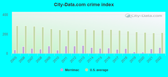
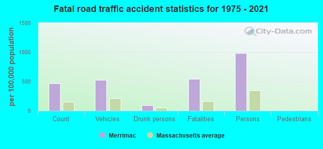
Crime rate in Merrimac detailed stats: murders, rapes, robberies, assaults, burglaries, thefts, arson
Full-time law enforcement employees in 2016, including police officers: 11 (7 officers - 7 male; 0 female).
| Officers per 1,000 residents here: | 1.02 |
| Massachusetts average: | 2.63 |
 Recent articles from our blog. Our writers, many of them Ph.D. graduates or candidates, create easy-to-read articles on a wide variety of topics.


Latest news from Merrimac, MA collected exclusively by city-data.com from local newspapers, TV, and radio stations
Ancestries: Irish (26.5%), English (20.5%), French (17.0%), Italian (12.5%), French Canadian (6.8%), Polish (6.4%).
Current Local Time: EST time zone
Incorporated in 1876
Elevation: 107 feet
Land area: 8.53 square miles.
Population density: 743 people per square mile (low).
110 residents are foreign born
| This town: | 1.8% |
| Massachusetts: | 12.2% |
| Merrimac town: | 1.2% ($2,464) |
| Massachusetts: | 1.3% ($2,336) |
Nearest city with pop. 50,000+: Haverhill, MA  (5.7 miles , pop. 58,969).
Nearest city with pop. 200,000+: Boston, MA (35.7 miles , pop. 589,141).
Nearest city with pop. 1,000,000+: Bronx, NY (201.9 miles , pop. 1,332,650).
Nearest cities:
), ), )Latitude: 42.83 N, Longitude: 71.00 W
Area code: 978

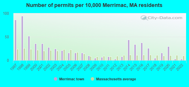
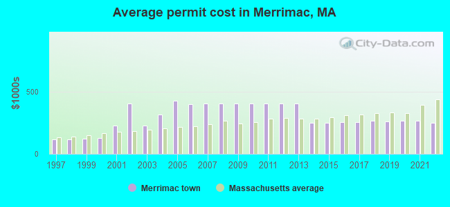
Single-family new house construction building permits:
- 2022: 2 buildings, average cost: $250,000
- 2021: 2 buildings, average cost: $263,900
- 2020: 18 buildings, average cost: $263,100
- 2019: 10 buildings, average cost: $262,400
- 2018: 3 buildings, average cost: $266,000
- 2017: 16 buildings, average cost: $256,900
- 2016: 23 buildings, average cost: $254,300
- 2015: 21 buildings, average cost: $250,000
- 2014: 27 buildings, average cost: $250,000
- 2013: 5 buildings, average cost: $402,100
- 2012: 2 buildings, average cost: $403,500
- 2011: 5 buildings, average cost: $403,500
- 2010: 4 buildings, average cost: $403,500
- 2009: 3 buildings, average cost: $403,500
- 2008: 6 buildings, average cost: $403,500
- 2007: 10 buildings, average cost: $406,200
- 2006: 10 buildings, average cost: $398,100
- 2005: 10 buildings, average cost: $425,000
- 2004: 13 buildings, average cost: $315,400
- 2003: 15 buildings, average cost: $223,500
- 2002: 17 buildings, average cost: $401,500
- 2001: 22 buildings, average cost: $223,500
- 2000: 22 buildings, average cost: $126,800
- 1999: 32 buildings, average cost: $122,900
- 1998: 58 buildings, average cost: $114,900
- 1997: 53 buildings, average cost: $114,700
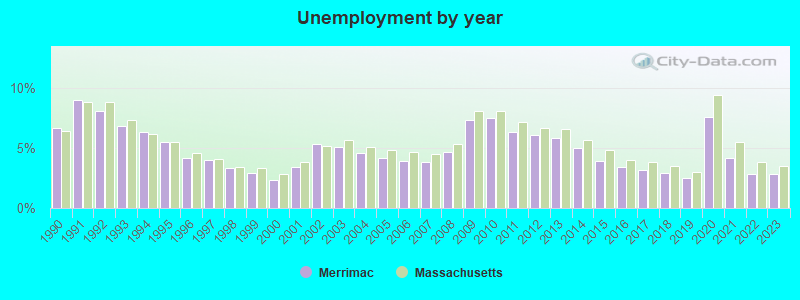
| Here: | 2.8% |
| Massachusetts: | 3.5% |
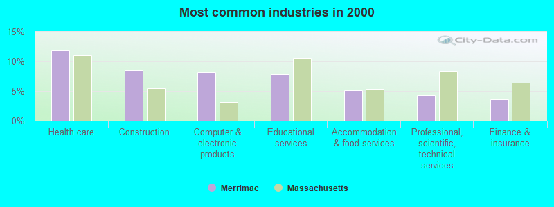
- Health care (11.9%)
- Construction (8.5%)
- Computer & electronic products (8.2%)
- Educational services (7.9%)
- Accommodation & food services (5.1%)
- Professional, scientific, technical services (4.4%)
- Finance & insurance (3.6%)
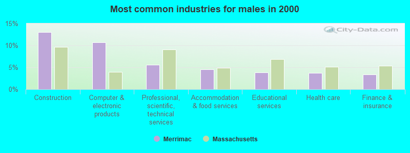
- Construction (13.0%)
- Computer & electronic products (10.7%)
- Professional, scientific, technical services (5.6%)
- Accommodation & food services (4.6%)
- Educational services (3.8%)
- Health care (3.7%)
- Finance & insurance (3.4%)
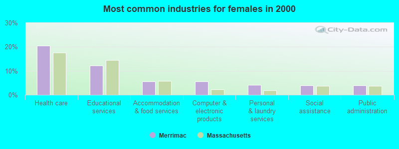
- Health care (20.5%)
- Educational services (12.3%)
- Accommodation & food services (5.6%)
- Computer & electronic products (5.5%)
- Personal & laundry services (4.0%)
- Social assistance (4.0%)
- Public administration (3.9%)
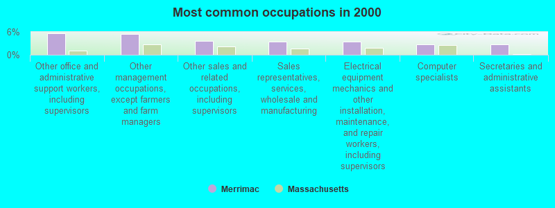
- Other office and administrative support workers, including supervisors (5.6%)
- Other management occupations, except farmers and farm managers (5.5%)
- Other sales and related occupations, including supervisors (3.6%)
- Sales representatives, services, wholesale and manufacturing (3.5%)
- Electrical equipment mechanics and other installation, maintenance, and repair workers, including supervisors (3.5%)
- Computer specialists (2.8%)
- Secretaries and administrative assistants (2.8%)
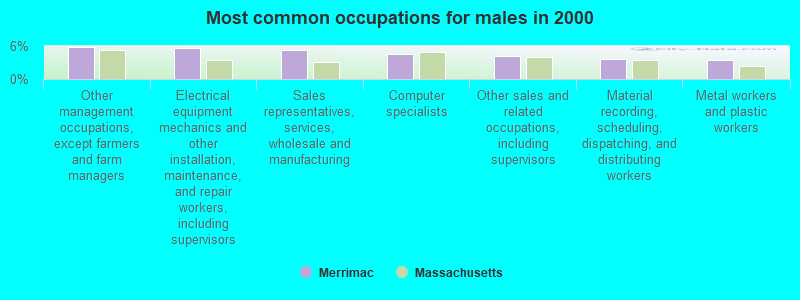
- Other management occupations, except farmers and farm managers (5.8%)
- Electrical equipment mechanics and other installation, maintenance, and repair workers, including supervisors (5.6%)
- Sales representatives, services, wholesale and manufacturing (5.2%)
- Computer specialists (4.5%)
- Other sales and related occupations, including supervisors (4.2%)
- Material recording, scheduling, dispatching, and distributing workers (3.7%)
- Metal workers and plastic workers (3.4%)
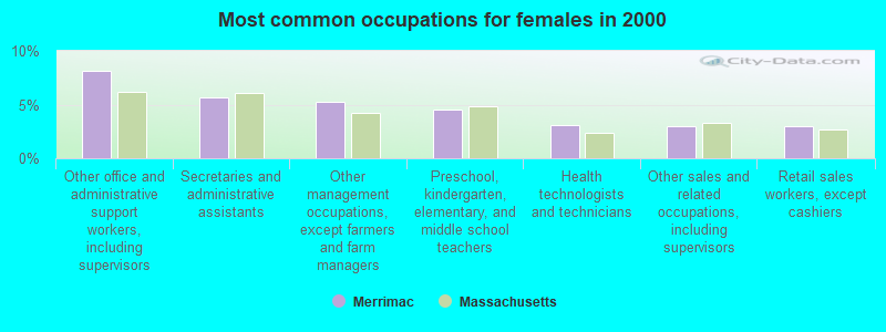
- Other office and administrative support workers, including supervisors (8.2%)
- Secretaries and administrative assistants (5.7%)
- Other management occupations, except farmers and farm managers (5.2%)
- Preschool, kindergarten, elementary, and middle school teachers (4.5%)
- Health technologists and technicians (3.1%)
- Other sales and related occupations, including supervisors (2.9%)
- Retail sales workers, except cashiers (2.9%)
Average climate in Merrimac, Massachusetts
Based on data reported by over 4,000 weather stations


(lower is better)
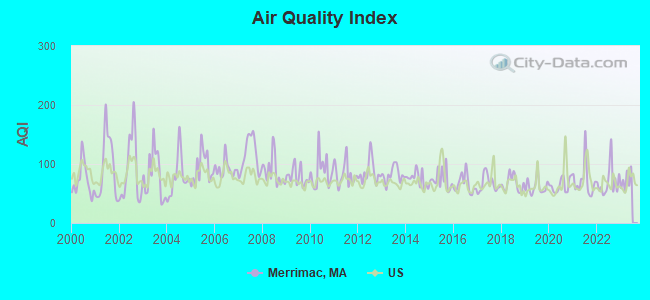
Air Quality Index (AQI) level in 2022 was 70.0. This is about average.
| City: | 70.0 |
| U.S.: | 72.6 |
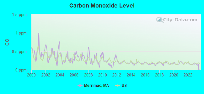
Carbon Monoxide (CO) [ppm] level in 2022 was 0.157. This is significantly better than average. Closest monitor was 19.2 miles away from the city center.
| City: | 0.157 |
| U.S.: | 0.251 |
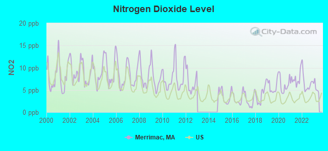
Nitrogen Dioxide (NO2) [ppb] level in 2022 was 6.56. This is worse than average. Closest monitor was 5.4 miles away from the city center.
| City: | 6.56 |
| U.S.: | 5.11 |
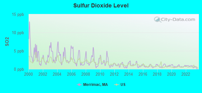
Sulfur Dioxide (SO2) [ppb] level in 2022 was 0.873. This is significantly better than average. Closest monitor was 5.2 miles away from the city center.
| City: | 0.873 |
| U.S.: | 1.515 |
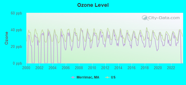
Ozone [ppb] level in 2022 was 28.8. This is about average. Closest monitor was 3.7 miles away from the city center.
| City: | 28.8 |
| U.S.: | 33.3 |
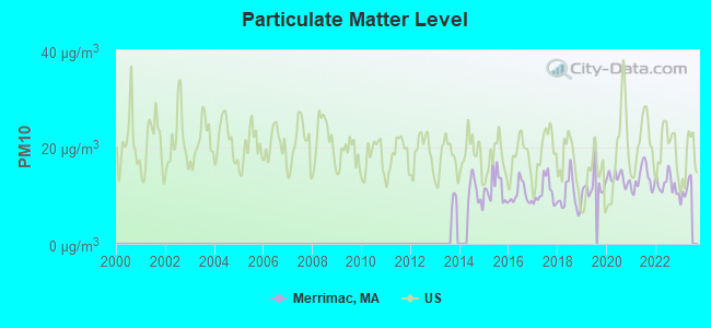
Particulate Matter (PM10) [µg/m3] level in 2022 was 12.3. This is significantly better than average. Closest monitor was 11.3 miles away from the city center.
| City: | 12.3 |
| U.S.: | 19.2 |
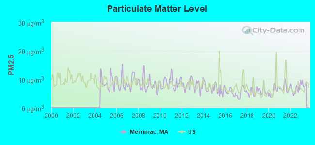
Particulate Matter (PM2.5) [µg/m3] level in 2022 was 6.65. This is better than average. Closest monitor was 6.7 miles away from the city center.
| City: | 6.65 |
| U.S.: | 8.11 |
Tornado activity:
Merrimac-area historical tornado activity is slightly below Massachusetts state average. It is 46% smaller than the overall U.S. average.
On 6/9/1953, a category F3 (max. wind speeds 158-206 mph) tornado 9.5 miles away from the Merrimac town center injured 5 people and caused between $5000 and $50,000 in damages.
On 9/29/1974, a category F3 tornado 17.9 miles away from the town center injured one person and caused between $50,000 and $500,000 in damages.
Earthquake activity:
Merrimac-area historical earthquake activity is significantly above Massachusetts state average. It is 73% smaller than the overall U.S. average.On 4/20/2002 at 10:50:47, a magnitude 5.3 (5.3 ML, Depth: 3.0 mi, Class: Moderate, Intensity: VI - VII) earthquake occurred 177.9 miles away from the city center
On 1/19/1982 at 00:14:42, a magnitude 4.7 (4.5 MB, 4.7 MD, 4.5 LG, Class: Light, Intensity: IV - V) earthquake occurred 55.0 miles away from the city center
On 10/16/2012 at 23:12:25, a magnitude 4.7 (4.7 ML, Depth: 10.0 mi) earthquake occurred 55.6 miles away from Merrimac center
On 10/7/1983 at 10:18:46, a magnitude 5.3 (5.1 MB, 5.3 LG, 5.1 ML) earthquake occurred 184.8 miles away from the city center
On 4/20/2002 at 10:50:47, a magnitude 5.2 (5.2 MB, 4.2 MS, 5.2 MW, 5.0 MW) earthquake occurred 177.6 miles away from Merrimac center
On 8/22/1992 at 12:20:32, a magnitude 4.8 (4.8 MB, 3.8 MS, 4.7 LG, Depth: 6.2 mi) earthquake occurred 260.3 miles away from Merrimac center
Magnitude types: regional Lg-wave magnitude (LG), body-wave magnitude (MB), duration magnitude (MD), local magnitude (ML), surface-wave magnitude (MS), moment magnitude (MW)
Natural disasters:
The number of natural disasters in Essex County (33) is a lot greater than the US average (15).Major Disasters (Presidential) Declared: 20
Emergencies Declared: 13
Causes of natural disasters: Floods: 14, Storms: 11, Hurricanes: 6, Snowstorms: 5, Winter Storms: 5, Snows: 3, Blizzards: 2, Fire: 1, Heavy Rain: 1, Snowfall: 1, Water Main Break: 1, Wind: 1 (Note: some incidents may be assigned to more than one category).

Hospitals and medical centers near Merrimac:
- EXCELLA HOMECARE INC (Home Health Center, about 3 miles away; AMESBURY, MA)
- AMESBURY VILLAGE (Nursing Home, about 4 miles away; AMESBURY, MA)
- MERRIMACK VALLEY NSG AND REH CTR (Nursing Home, about 4 miles away; AMESBURY, MA)
- LAKEVIEW HOUSE NH (Nursing Home, about 4 miles away; HAVERHILL, MA)
- LAKEVIEW HOUSE SKLD NRSG AND RESIDENTIAL CARE FAC (Nursing Home, about 4 miles away; HAVERHILL, MA)
- DSI AMESBURY RENAL CENTER (Dialysis Facility, about 4 miles away; AMESBURY, MA)
- AMESBURY HOSPITAL (Hospital, about 4 miles away; AMESBURY, MA)
Operable nuclear power plant near Merrimac:
- 9 miles: Seabrook in Seabrook, NH.
Colleges/universities with over 2000 students nearest to Merrimac:
- Northern Essex Community College (about 4 miles; Haverhill, MA; Full-time enrollment: 4,737)
- Merrimack College (about 14 miles; North Andover, MA; FT enrollment: 2,734)
- North Shore Community College (about 17 miles; Danvers, MA; FT enrollment: 5,195)
- University of Massachusetts-Lowell (about 21 miles; Lowell, MA; FT enrollment: 12,341)
- University of New Hampshire-Main Campus (about 22 miles; Durham, NH; FT enrollment: 15,243)
- Endicott College (about 22 miles; Beverly, MA; FT enrollment: 4,064)
- Salem State University (about 24 miles; Salem, MA; FT enrollment: 8,027)
Public elementary/middle schools in Merrimac:
- HELEN R DONAGHUE SCHOOL (Students: 401, Location: 24 UNION STREET EXT., Grades: 3-6)
- DR FREDERICK N SWEETSIR (Students: 331, Location: 104 CHURCH STREET, Grades: PK-2)
Points of interest:
Notable locations in Merrimac: Merrimac Fire Department (A), Thomas Hoyt Memorial Library (B). Display/hide their locations on the map
Cemeteries: Locust Grove Cemetery (1), Church Street Cemetery (2), Lower Corner Cemetery (3). Display/hide their locations on the map
Lakes and swamps: Sargent Millpond (A), Neal Pond (B). Display/hide their locations on the map
Streams, rivers, and creeks: Cobbler Brook (A). Display/hide its location on the map
Birthplace of: William Wheelwright - Americna businessman, Dennis Berran - Major League Baseball outfielder, George W. Weymouth - Politician.
Drinking water stations with addresses in Merrimac and their reported violations in the past:
MERRIMAC WATER DEPARTMENT (Population served: 6,338, Groundwater):Past monitoring violations:
- Monitoring and Reporting (DBP) - Between JUL-2007 and SEP-2007, Contaminant: Total Haloacetic Acids (HAA5). Follow-up actions: St AO (w/o penalty) issued (OCT-23-2007)
- Monitoring and Reporting (DBP) - Between JUL-2007 and SEP-2007, Contaminant: TTHM. Follow-up actions: St AO (w/o penalty) issued (OCT-23-2007)
- Follow-up Or Routine LCR Tap M/R - In OCT-01-2005, Contaminant: Lead and Copper Rule. Follow-up actions: St AO (w/o penalty) issued (JAN-30-2006), St Compliance achieved (JUL-12-2006)
- One routine major monitoring violation
- 125 regular monitoring violations
Drinking water stations with addresses in Merrimac that have no violations reported:
- BRYANT BROOK (Serves NH, Population served: 55, Primary Water Source Type: Groundwater)
| This town: | 2.6 people |
| Massachusetts: | 2.5 people |
| This town: | 72.0% |
| Whole state: | 63.0% |
| This town: | 6.3% |
| Whole state: | 7.0% |
Likely homosexual households (counted as self-reported same-sex unmarried-partner households)
- Lesbian couples: 0.7% of all households
- Gay men: 0.5% of all households
| This town: | 2.7% |
| Whole state: | 9.3% |
| This town: | 1.1% |
| Whole state: | 4.4% |
People in group quarters in Merrimac in 2010:
- 12 people in group homes for juveniles (non-correctional)
- 6 people in group homes intended for adults
- 5 people in residential schools for people with disabilities
People in group quarters in Merrimac in 2000:
- 14 people in homes for abused, dependent, and neglected children
- 9 people in homes for the mentally retarded
- 7 people in residential treatment centers for emotionally disturbed children
- 4 people in other noninstitutional group quarters
Banks with branches in Merrimac (2011 data):
- Haverhill Bank: West Main Street Branch at 6 Main Street, branch established on 1889/01/01. Info updated 2012/01/20: Bank assets: $260.7 mil, Deposits: $219.7 mil, headquarters in Haverhill, MA, positive income, Mortgage Lending Specialization, 7 total offices
- Merrimac Savings Bank: at 1 West Main Street, branch established on 1871/04/19. Info updated 2006/10/23: Bank assets: $63.4 mil, Deposits: $56.2 mil, local headquarters, positive income, Mortgage Lending Specialization, 2 total offices
For population 15 years and over in Merrimac:
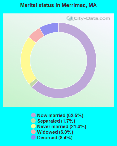
- Never married: 21.4%
- Now married: 62.5%
- Separated: 1.7%
- Widowed: 6.0%
- Divorced: 8.4%
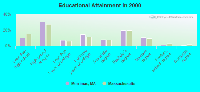
For population 25 years and over in Merrimac:
- High school or higher: 90.2%
- Bachelor's degree or higher: 30.8%
- Graduate or professional degree: 11.3%
- Unemployed: 2.4%
- Mean travel time to work (commute): 28.2 minutes
| Here: | 10.3 |
| Massachusetts average: | 13.1 |


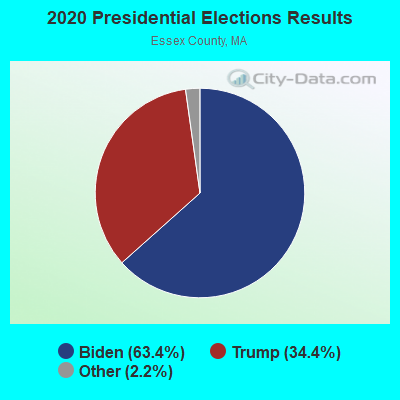
Graphs represent county-level data. Detailed 2008 Election Results
Religion statistics for Merrimac, MA (based on Essex County data)


| Religion | Adherents | Congregations |
|---|---|---|
| Catholic | 341,970 | 55 |
| Mainline Protestant | 33,710 | 140 |
| Evangelical Protestant | 20,925 | 160 |
| Other | 15,882 | 63 |
| Orthodox | 11,590 | 13 |
| Black Protestant | 376 | 3 |
| None | 318,706 | - |
Food Environment Statistics:
| Here: | 1.98 / 10,000 pop. |
| Massachusetts: | 1.98 / 10,000 pop. |
| Essex County: | 0.04 / 10,000 pop. |
| State: | 0.05 / 10,000 pop. |
| This county: | 1.97 / 10,000 pop. |
| Massachusetts: | 2.22 / 10,000 pop. |
| Essex County: | 1.30 / 10,000 pop. |
| State: | 1.77 / 10,000 pop. |
| Essex County: | 7.60 / 10,000 pop. |
| Massachusetts: | 8.76 / 10,000 pop. |
| Essex County: | 8.4% |
| Massachusetts: | 8.1% |
| Essex County: | 23.7% |
| Massachusetts: | 22.5% |
| Essex County: | 20.7% |
| Massachusetts: | 16.5% |
5.09% of this county's 2021 resident taxpayers lived in other counties in 2020 ($96,821 average adjusted gross income)
| Here: | 5.09% |
| Massachusetts average: | 6.35% |
0.01% of residents moved from foreign countries ($21 average AGI)
Essex County: 0.01% Massachusetts average: 0.01%
Top counties from which taxpayers relocated into this county between 2020 and 2021:
| from Middlesex County, MA | |
| from Suffolk County, MA | |
| from Rockingham County, NH |
5.47% of this county's 2020 resident taxpayers moved to other counties in 2021 ($95,440 average adjusted gross income)
| Here: | 5.47% |
| Massachusetts average: | 7.18% |
0.01% of residents moved to foreign countries ($53 average AGI)
Essex County: 0.01% Massachusetts average: 0.02%
Top counties to which taxpayers relocated from this county between 2020 and 2021:
| to Middlesex County, MA | |
| to Rockingham County, NH | |
| to Suffolk County, MA |
| Businesses in Merrimac, MA | ||||
| Name | Count | Name | Count | |
|---|---|---|---|---|
| Decora Cabinetry | 2 | FedEx | 1 | |
| Dunkin Donuts | 1 | MasterBrand Cabinets | 2 | |
Strongest AM radio stations in Merrimac:
- WRKO (680 AM; 50 kW; BOSTON, MA; Owner: ENTERCOM BOSTON LICENSE, LLC)
- WDER (1320 AM; 10 kW; DERRY, NH; Owner: BLOUNT COMMUNICATIONS, INC. OF NH)
- WEEI (850 AM; 50 kW; BOSTON, MA; Owner: ENTERCOM BOSTON LICENSE, LLC)
- WWZN (1510 AM; 50 kW; BOSTON, MA; Owner: ROSE CITY RADIO CORPORATION)
- WBZ (1030 AM; 50 kW; BOSTON, MA; Owner: INFINITY BROADCASTING OPERATIONS, INC.)
- WGIP (1540 AM; 5 kW; EXETER, NH; Owner: CAPSTAR TX LIMITED PARTNERSHIP)
- WKOX (1200 AM; 50 kW; FRAMINGHAM, MA; Owner: CAPSTAR TX LIMITED PARTNERSHIP)
- WCEC (1110 AM; daytime; 5 kW; SALEM, NH; Owner: COSTA-EAGLE RADIO VENTURES LTD PARTNERSHIP)
- WBIX (1060 AM; 40 kW; NATICK, MA; Owner: LANGER BROADCASTING CORPORATION)
- WCCM (1490 AM; 1 kW; HAVERHILL, MA; Owner: COSTA-EAGLE RADIO VENTURES LTD P/SHI)
- WCRN (830 AM; 50 kW; WORCESTER, MA; Owner: CARTER BROADCASTING CORPORATION)
- WRCA (1330 AM; 25 kW; WALTHAM, MA; Owner: WRCA LICENSE, LLC)
- WNBP (1450 AM; 1 kW; NEWBURYPORT, MA; Owner: RADIO NEWBURYPORT, LLC)
Strongest FM radio stations in Merrimac:
- WXRV (92.5 FM; HAVERHILL, MA; Owner: BEANPOT BROADCASTING CORP.)
- WNEF (91.7 FM; NEWBURYPORT, MA; Owner: UNIVERSITY OF MASSACHUSETTS)
- WSAK (102.1 FM; HAMPTON, NH; Owner: CITADEL BROADCASTING COMPANY)
- WKLB-FM (99.5 FM; LOWELL, MA; Owner: GREATER BOSTON RADIO, INC.)
- W227AM (93.3 FM; ANDOVER, MA; Owner: GREATER BOSTON RADIO, INC.)
- WQSX (93.7 FM; LAWRENCE, MA; Owner: ENTERCOM BOSTON LICENSE, LLC)
- WXKS-FM (107.9 FM; MEDFORD, MA; Owner: AMFM RADIO LICENSES, L.L.C.)
- WMJX (106.7 FM; BOSTON, MA; Owner: GREATER BOSTON RADIO, INC.)
- WGIR-FM (101.1 FM; MANCHESTER, NH; Owner: CAPSTAR TX LIMITED PARTNERSHIP)
- WQLL (96.5 FM; BEDFORD, NH; Owner: SAGA COMMUNICATIONS OF NEW ENGLAND, LLC)
- WERZ (107.1 FM; EXETER, NH; Owner: CAPSTAR TX LIMITED PARTNERSHIP)
- WLMW (90.7 FM; MANCHESTER, NH; Owner: KNOWLEDGE FOR LIFE)
- WHOB (106.3 FM; NASHUA, NH; Owner: TELE-MEDIA COMPANY OF NEW HAMPSHIRE, L.L.C.)
- WZID (95.7 FM; MANCHESTER, NH; Owner: SAGA COMMUNICATIONS OF NEW ENGLAND, LLC)
- WBMX (98.5 FM; BOSTON, MA; Owner: INFINITY RADIO OPERATIONS INC.)
- WJMN (94.5 FM; BOSTON, MA; Owner: AMFM RADIO LICENSES, L.L.C.)
- WHEB (100.3 FM; PORTSMOUTH, NH; Owner: CAPSTAR TX LIMITED PARTNERSHIP)
- WCRB (102.5 FM; WALTHAM, MA; Owner: CHARLES RIVER BROADCASTING WCRB LICE)
- WTKK (96.9 FM; BOSTON, MA; Owner: GREATER BOSTON RADIO, INC.)
- WROR-FM (105.7 FM; FRAMINGHAM, MA; Owner: GREATER BOSTON RADIO, INC.)
TV broadcast stations around Merrimac:
- WHDN-LP (Channel 26; BOSTON, MA; Owner: GUENTER MARKSTEINER)
- WFXZ-CA (Channel 24; BOSTON, MA; Owner: BOSTON BROADCASTING CORP.)
- WCVB-TV (Channel 5; BOSTON, MA; Owner: WCVB HEARST-ARGYLE TV, INC.)
- WGBH-TV (Channel 2; BOSTON, MA; Owner: WGBH EDUCATIONAL FOUNDATION)
- WMEA-TV (Channel 26; BIDDEFORD, ME; Owner: MAINE PUBLIC BROADCASTING CORP.)
- WHDH-TV (Channel 7; BOSTON, MA; Owner: WHDH-TV)
- WMFP (Channel 62; LAWRENCE, MA; Owner: WSAH LICENSE, INC.)
- WSBK-TV (Channel 38; BOSTON, MA; Owner: VIACOM INC.)
- WBZ-TV (Channel 4; BOSTON, MA; Owner: VIACOM INC.)
- WGBX-TV (Channel 44; BOSTON, MA; Owner: WGBH EDUCATIONAL FOUNDATION)
- WLVI-TV (Channel 56; CAMBRIDGE, MA; Owner: WLVI, INC.)
- WBPX (Channel 68; BOSTON, MA; Owner: PAXSON BOSTON-68 LICENSE, INC.)
- WFXT (Channel 25; BOSTON, MA; Owner: FOX TELEVISION STATIONS INC.)
- WUTF (Channel 66; MARLBOROUGH, MA; Owner: TELEFUTURA BOSTON LLC)
- WNDS (Channel 50; DERRY, NH; Owner: CTV OF DERRY, INC)
- WTMU-LP (Channel 32; BOSTON, MA; Owner: ZGS BOSTON, INC.)
- WCEA-LP (Channel 58; BOSTON, MA; Owner: CHANNEL 19 TV CORPORATION)
- WENH-TV (Channel 11; DURHAM, NH; Owner: UNIVERSITY OF NEW HAMPSHIRE)
- WUNI (Channel 27; WORCESTER, MA; Owner: ENTRAVISION HOLDINGS, LLC)
- W40BO (Channel 40; BOSTON, MA; Owner: PAXSON COMMUNICATIONS LPTV, INC.)
- National Bridge Inventory (NBI) Statistics
- 9Number of bridges
- 98ft / 30.5mTotal length
- $23,234,000Total costs
- 128,150Total average daily traffic
- 587Total average daily truck traffic
FCC Registered Antenna Towers:
6- Lottie L Thompson, W Main St (Lat: 42.825833 Lon: -71.013611), Type: 45.1, Overall height: 45.1 m, Registrant: Spectrasite Communications, Inc. Through American Tower, Inc., Atcfaa-Fccnortheast@americantower.Com, , Wobur-n, Phone: (617) 585-7614
- Tim McDougall, W Main St (Lat: 42.825833 Lon: -71.013611), Type: 45.1, Overall height: 45.1 m, Registrant: Spectrasite Communications, Inc. Through American Tower, Inc., Atcfaa-Fccnortheast@americantower.Com, , Wobur-n, Phone: (617) 585-7614
- TERRY L ARMANT, W Main St (Lat: 42.825833 Lon: -71.013611), Type: 45.1, Overall height: 45.1 m, Registrant: Spectrasite Communications, Inc., Maria.Gabriel@spectrasite.Com, , Cary, Phone: (919) 468-0112
- Tim McDougall, W Main St (Lat: 42.825833 Lon: -71.013611), Type: 45.1, Overall height: 45.1 m, Registrant: Spectrasite Communications, Inc. Through American Tower, Inc., Atcfaa-Fccnortheast@americantower.Com, , Bosto-n, Phone: (617) 585-7600
- CARISSA L BICK, W Main St (Lat: 42.825833 Lon: -71.013611), Type: 45.1, Overall height: 45.1 m, Registrant: Spectrasite Communications, Inc. Through American Tower, Inc., Atcfaa-Fccnortheast@americantower.Com, , Wobur-n, Phone: (617) 585-7614
- W Main St (Lat: 42.825833 Lon: -71.013611), Type: 45.1, Overall height: 45.1 m, Registrant: Dispatch Communications Of New England Inc Dba , Shari.Pogach@nextel.Com, , Mclea-n, Phone: (703) 394-3526
FCC Registered Private Land Mobile Towers:
1- 84 Main St. (Lat: 42.825083 Lon: -71.011722), Type: Tower, Structure height: 46 m, Call Sign: WPLA750,
Assigned Frequencies: 862.037 MHz, 862.062 MHz, 862.087 MHz, 862.112 MHz, 862.137 MHz, 862.162 MHz, 862.187 MHz, 862.212 MHz, 862.237 MHz, 862.262 MHz... (+148 more), Grant Date: 02/28/2012, Expiration Date: 02/06/2022, Cancellation Date: 09/12/2019, Registrant: Sprint Corporation, 12502 Sunrise Valley Drive, M/S: Varesa-0209, Reston, VA 20196, Phone: (800) 572-8256, Fax: (703) 433-4483, Email:
FCC Registered Broadcast Land Mobile Towers:
5- 16 E Main St (Lat: 42.834528 Lon: -71.000611), Call Sign: KBX936,
Assigned Frequencies: 154.010 MHz, 154.070 MHz, 154.145 MHz, 154.190 MHz, Grant Date: 05/14/2002, Expiration Date: 07/09/2012, Cancellation Date: 09/08/2012, Registrant: Tcs Communications Corp, 85 Lafayette Road, Salisbury, MA 01952, Phone: (978) 465-7932, Fax: (978) 462-8980, Email:
- 2 School St (Lat: 42.832583 Lon: -71.001722), Call Sign: KNES952, Licensee ID: L00044648,
Assigned Frequencies: 173.362 MHz, Grant Date: 06/25/2013, Expiration Date: 01/13/2023, Cancellation Date: 03/18/2023, Registrant: Merrimac Municipal Light Co, 10 W Main St, Merrimac, MA 01860, Phone: (978) 346-8311
- 2 School St (Lat: 42.832583 Lon: -71.001722), Call Sign: KXM568, Licensee ID: L00044648,
Assigned Frequencies: 47.7200 MHz, Grant Date: 07/17/2014, Expiration Date: 08/21/2024, Registrant: Merrimac, Town Of, 10 W Main St, Merrimac, MA 01860, Phone: (978) 346-8311
- SARGENT PIT PS, Sargent Pit Pumping Station (Lat: 42.862222 Lon: -71.011667), Type: Mast, Structure height: 7 m, Overall height: 9 m, Call Sign: WQPC684,
Assigned Frequencies: 217.750 MHz, Grant Date: 03/09/2022, Expiration Date: 04/06/2032, Certifier: Carol Traynor, Registrant: Business Radio Licensing, 30251 Golden Lantern Suite E # 501, Laguna Niguel, CA 92677, Phone: (949) 348-8510, Fax: (949) 348-8514, Email:
- 16 East Main Street (Lat: 42.834528 Lon: -71.000611), Type: Gtower, Structure height: 37 m, Call Sign: WQSB556,
Assigned Frequencies: 460.187 MHz, Grant Date: 06/27/2023, Expiration Date: 08/27/2033, Certifier: Mike Lemieux, Registrant: Cyber Communications, Inc., 250 Cape Highway, Route 44, East Taunton, MA 02718, Phone: (508) 880-3294, Fax: (508) 880-6745, Email:
FCC Registered Microwave Towers:
1- MERRIMAC, Tucker Hill (Lat: 42.825917 Lon: -71.013667), Overall height: 40.2 m, Call Sign: WMW967,
Assigned Frequencies: 10618.7 MHz, Grant Date: 03/02/2010, Expiration Date: 04/01/2020, Cancellation Date: 12/23/2015, Certifier: Carol L Tacker, Registrant: At&t Mobility LLC, 1120 20th Street, Nw - Suite 1000, Washington, DC 20036, Phone: (202) 457-2055, Fax: (202) 457-3073, Email:
FCC Registered Amateur Radio Licenses:
19 (See the full list of FCC Registered Amateur Radio Licenses in Merrimac)FAA Registered Aircraft:
2- Aircraft: PIPER PA-32R-301 (Category: Land, Seats: 7, Weight: Up to 12,499 Pounds), Engine: LYCOMING IO-540 SER (300 HP) (Reciprocating)
N-Number: 4360C, N4360C, N-4360C, Serial Number: 32R-8413016, Year manufactured: 1984, Airworthiness Date: 05/22/1984, Certificate Issue Date: 05/27/2004
Registrant (Individual): John M Trustee Cryan, 102 River Rd, Merrimac, MA 01860 - Aircraft: TAYLORCRAFT BL-65 (Category: Land, Seats: 2, Weight: Up to 12,499 Pounds, Speed: 78 mph), Engine: LYCOMING 0-145B SERIES (65 HP) (Reciprocating)
N-Number: 20450, N20450, N-20450, Serial Number: 1137, Year manufactured: 1939, Airworthiness Date: 11/12/1958, Certificate Issue Date: 11/07/1961
Registrant (Individual): F Wesley Bishop, 52 Church St, Merrimac, MA 01860
Deregistered: Cancel Date: 02/12/2018
2002 - 2018 National Fire Incident Reporting System (NFIRS) incidents
- Fire incident types reported to NFIRS in Merrimac, MA
- 38746.9%Structure Fires
- 28935.0%Outside Fires
- 10412.6%Mobile Property/Vehicle Fires
- 455.5%Other
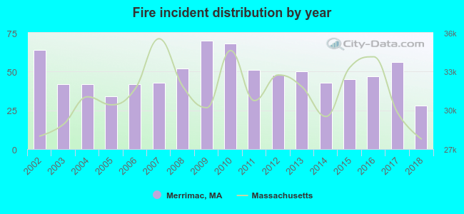 According to the data from the years 2002 - 2018 the average number of fire incidents per year is 49. The highest number of reported fire incidents - 70 took place in 2009, and the least - 28 in 2018. The data has a dropping trend.
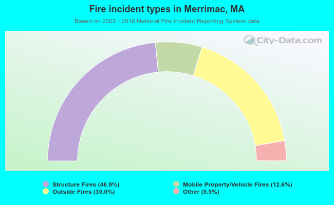 When looking into fire subcategories, the most reports belonged to: Structure Fires (46.9%), and Outside Fires (35.0%).
- 55.7%Utility gas
- 33.4%Fuel oil, kerosene, etc.
- 4.4%Bottled, tank, or LP gas
- 3.4%Wood
- 3.1%Electricity
- 46.2%Utility gas
- 29.2%Fuel oil, kerosene, etc.
- 17.5%Electricity
- 5.0%Bottled, tank, or LP gas
- 2.1%Other fuel
Merrimac compared to Massachusetts state average:
- Unemployed percentage significantly below state average.
- Black race population percentage significantly below state average.
- Hispanic race population percentage significantly below state average.
- Median age above state average.
- Foreign-born population percentage significantly below state average.
- Renting percentage below state average.
- Length of stay since moving in significantly above state average.
- Number of rooms per house significantly below state average.
- House age significantly below state average.
- Number of college students below state average.
Merrimac on our top lists:
- #4 on the list of "Top 101 cities with largest percentage of males in occupations: social scientists and related workers (population 5,000+)"
- #11 on the list of "Top 101 cities with largest percentage of males in occupations: entertainers and performers, sports, and related workers (population 5,000+)"
- #16 on the list of "Top 101 cities with largest percentage of males in occupations: drafters, engineering, and mapping technicians (population 5,000+)"
- #18 on the list of "Top 101 cities with largest percentage of males in industries: leather and allied products (population 5,000+)"
- #25 on the list of "Top 101 cities with largest percentage of females in occupations: librarians, curators, and archivists (population 5,000+)"
- #29 on the list of "Top 101 cities with largest percentage of females in occupations: drafters, engineering, and mapping technicians (population 5,000+)"
- #35 on the list of "Top 101 cities with largest percentage of males in industries: computer and electronic products (population 5,000+)"
- #38 on the list of "Top 101 cities with largest percentage of females in occupations: architects, surveyors, and cartographers (population 5,000+)"
- #39 on the list of "Top 101 cities with largest percentage of males in industries: miscellaneous nondurable goods merchant wholesalers (population 5,000+)"
- #41 on the list of "Top 101 cities with largest percentage of females in industries: computer and electronic products (population 5,000+)"
- #43 on the list of "Top 101 cities with largest percentage of females in industries: electronic shopping and mail-order houses (population 5,000+)"
- #44 on the list of "Top 101 cities with largest percentage of females in industries: radio, tv, and computer stores (population 5,000+)"
- #49 on the list of "Top 101 cities with largest percentage of males in industries: drugs, sundries, and chemical and allied products merchant wholesalers (population 5,000+)"
- #54 on the list of "Top 101 cities with largest percentage of females in industries: broadcasting and telecommunications (population 5,000+)"
- #55 on the list of "Top 101 cities with largest percentage of females in industries: personal and laundry services (population 5,000+)"
- #56 on the list of "Top 101 cities with largest percentage of females in industries: petroleum and petroleum products merchant wholesalers (population 5,000+)"
- #59 on the list of "Top 101 cities with largest percentage of females in industries: office supplies and stationery stores (population 5,000+)"
- #61 on the list of "Top 101 cities with largest percentage of males in industries: sporting goods, camera, and hobby and toy stores (population 5,000+)"
- #64 on the list of "Top 101 cities with largest percentage of females in industries: electrical equipment, appliances, and components (population 5,000+)"
- #65 on the list of "Top 101 cities with largest percentage of females in industries: sewing, needlework, and piece goods stores (population 5,000+)"
- #21 on the list of "Top 101 counties with the lowest percentage of residents that keep firearms around their homes"
- #21 on the list of "Top 101 counties with the most Orthodox adherents"
- #23 on the list of "Top 101 counties with the highest carbon monoxide air pollution readings in 2012 (ppm)"
- #30 on the list of "Top 101 counties with the most Catholic adherents"
- #36 on the list of "Top 101 counties with the most Orthodox congregations (pop. 50,000+)"

|
|
Total of 90 patent applications in 2008-2024.