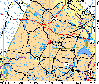
Nottingham, New Hampshire
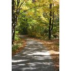
Nottingham: Entrance to Southside Cemetery in Nottingham N.H.
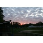
Nottingham: Sunset after a baseball game in Nottingham N.H.
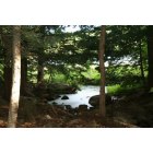
Nottingham: Pawtuckaway State Park in Nottingham N.H.
- add
your
Submit your own pictures of this town and show them to the world
- OSM Map
- General Map
- Google Map
- MSN Map
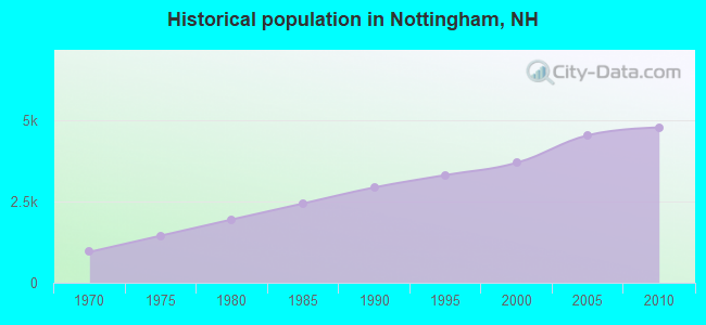
Population change since 2000: +29.3%
| Males: 2,422 | |
| Females: 2,363 |
| Median resident age: | 40.5 years |
| New Hampshire median age: | 43.9 years |
Zip codes: 03290.
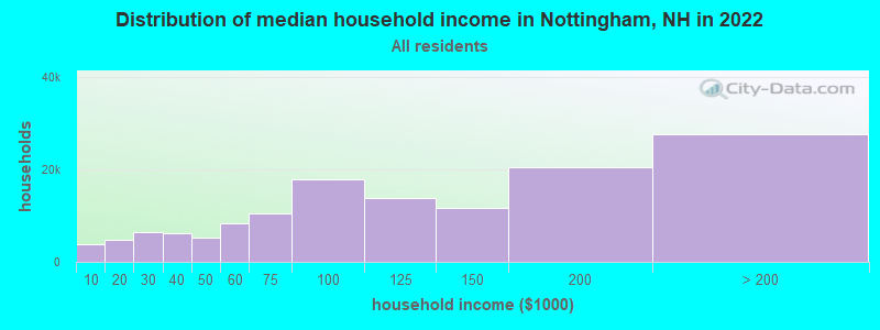
| Nottingham: | $115,337 |
| NH: | $89,992 |
Estimated per capita income in 2022: $54,612 (it was $24,879 in 2000)
Nottingham town income, earnings, and wages data
Estimated median house or condo value in 2022: $430,533 (it was $140,900 in 2000)
| Nottingham: | $430,533 |
| NH: | $384,700 |
Mean prices in 2022: all housing units: $614,227; detached houses: $665,470; townhouses or other attached units: $408,866; in 2-unit structures: $730,084; in 3-to-4-unit structures: over $1,000,000; in 5-or-more-unit structures: $329,099; mobile homes: $126,160
Detailed information about poverty and poor residents in Nottingham, NH


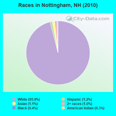
- 4,59195.9%White alone
- 561.2%Hispanic
- 511.1%Asian alone
- 501.0%Two or more races
- 200.4%Black alone
- 150.3%American Indian alone
- 20.04%Other race alone
Races in Nottingham detailed stats: ancestries, foreign born residents, place of birth
According to our research of New Hampshire and other state lists, there were 8 registered sex offenders living in Nottingham, New Hampshire as of April 25, 2024.
The ratio of all residents to sex offenders in Nottingham is 598 to 1.
The ratio of registered sex offenders to all residents in this city is near the state average.
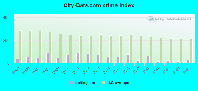
Type |
2009 |
2010 |
2011 |
2012 |
2013 |
2014 |
2015 |
2016 |
2017 |
2018 |
2019 |
2020 |
2021 |
2022 |
|---|---|---|---|---|---|---|---|---|---|---|---|---|---|---|
| Murders (per 100,000) | 0 (0.0) | 0 (0.0) | 0 (0.0) | 0 (0.0) | 0 (0.0) | 0 (0.0) | 0 (0.0) | 0 (0.0) | 0 (0.0) | 0 (0.0) | 0 (0.0) | 0 (0.0) | 0 (0.0) | 0 (0.0) |
| Rapes (per 100,000) | 0 (0.0) | 1 (20.9) | 0 (0.0) | 1 (20.8) | 0 (0.0) | 1 (20.4) | 0 (0.0) | 3 (60.3) | 0 (0.0) | 3 (58.5) | 0 (0.0) | 0 (0.0) | 0 (0.0) | 1 (18.7) |
| Robberies (per 100,000) | 0 (0.0) | 0 (0.0) | 0 (0.0) | 0 (0.0) | 0 (0.0) | 0 (0.0) | 1 (20.2) | 0 (0.0) | 0 (0.0) | 0 (0.0) | 0 (0.0) | 0 (0.0) | 0 (0.0) | 0 (0.0) |
| Assaults (per 100,000) | 1 (21.6) | 1 (20.9) | 2 (41.7) | 3 (62.4) | 4 (81.7) | 2 (40.7) | 2 (40.4) | 1 (20.1) | 0 (0.0) | 2 (39.0) | 3 (58.3) | 0 (0.0) | 0 (0.0) | 0 (0.0) |
| Burglaries (per 100,000) | 7 (151.3) | 9 (188.1) | 14 (292.2) | 11 (228.6) | 23 (469.9) | 8 (163.0) | 9 (182.0) | 6 (120.6) | 7 (138.7) | 1 (19.5) | 0 (0.0) | 4 (77.2) | 0 (0.0) | 0 (0.0) |
| Thefts (per 100,000) | 34 (734.7) | 45 (940.4) | 64 (1,336) | 34 (706.7) | 26 (531.2) | 20 (407.4) | 34 (687.6) | 20 (401.8) | 17 (336.9) | 8 (155.9) | 7 (135.9) | 23 (443.8) | 17 (321.9) | 12 (224.0) |
| Auto thefts (per 100,000) | 2 (43.2) | 2 (41.8) | 5 (104.4) | 4 (83.1) | 3 (61.3) | 0 (0.0) | 1 (20.2) | 1 (20.1) | 1 (19.8) | 1 (19.5) | 0 (0.0) | 1 (19.3) | 3 (56.8) | 3 (56.0) |
| Arson (per 100,000) | 0 (0.0) | 0 (0.0) | 0 (0.0) | 0 (0.0) | 0 (0.0) | 0 (0.0) | 0 (0.0) | 1 (20.1) | 0 (0.0) | 0 (0.0) | 0 (0.0) | 0 (0.0) | 0 (0.0) | 0 (0.0) |
| City-Data.com crime index | 47.8 | 75.0 | 90.6 | 80.0 | 75.4 | 52.1 | 56.0 | 78.4 | 24.8 | 63.7 | 17.1 | 24.7 | 17.4 | 28.4 |
The City-Data.com crime index weighs serious crimes and violent crimes more heavily. Higher means more crime, U.S. average is 246.1. It adjusts for the number of visitors and daily workers commuting into cities.
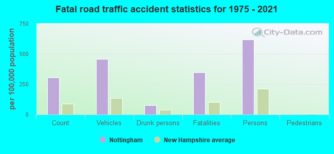
Crime rate in Nottingham detailed stats: murders, rapes, robberies, assaults, burglaries, thefts, arson
Full-time law enforcement employees in 2021, including police officers: 9 (8 officers - 7 male; 1 female).
| Officers per 1,000 residents here: | 1.51 |
| New Hampshire average: | 2.14 |
 Recent articles from our blog. Our writers, many of them Ph.D. graduates or candidates, create easy-to-read articles on a wide variety of topics.

 | New Hampshire is on my short list of locations to move to from Montana (42 replies) |
| Best safe towns for commute to Portsmouth NH (34 replies) |
| Fidium (8 replies) |
| What are the chances NH implements an income or sales tax in the next decade? (120 replies) |
| Nottinghammers looking for a good car repair place (9 replies) |
| Lake rentals other than Winnipesaukee (16 replies) |
Latest news from Nottingham, NH collected exclusively by city-data.com from local newspapers, TV, and radio stations
Ancestries: English (24.6%), Irish (19.7%), French (15.8%), German (8.2%), French Canadian (7.9%), Italian (6.8%).
Current Local Time: EST time zone
Incorporated in 1722
Elevation: 260 feet
Land area: 46.5 square miles.
Population density: 103 people per square mile (very low).
87 residents are foreign born (1.3% Europe, 0.9% Asia).
| This town: | 2.4% |
| New Hampshire: | 4.4% |
| Nottingham town: | 2.2% ($3,070) |
| New Hampshire: | 2.3% ($2,946) |
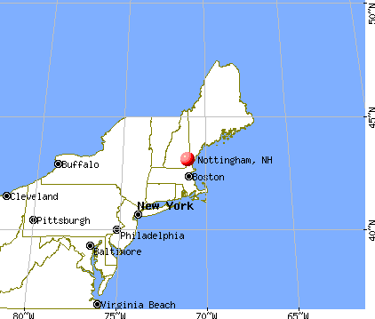
Nearest city with pop. 50,000+: Manchester, NH  (19.6 miles , pop. 107,006).
Nearest city with pop. 200,000+: Boston, MA (55.5 miles , pop. 589,141).
Nearest city with pop. 1,000,000+: Bronx, NY (212.0 miles , pop. 1,332,650).
Nearest cities:
), ), ), ), ), ), Latitude: 43.12 N, Longitude: 71.11 W
Area code commonly used in this area: 603

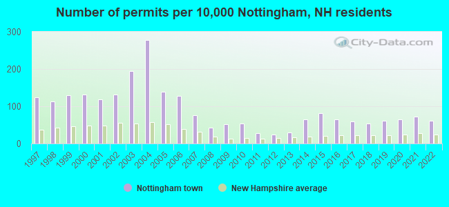
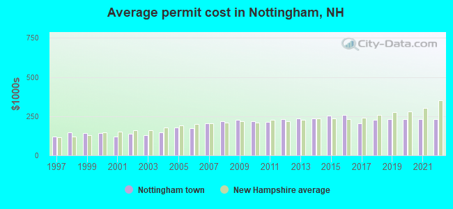
Single-family new house construction building permits:
- 2022: 23 buildings, average cost: $231,800
- 2021: 27 buildings, average cost: $231,900
- 2020: 24 buildings, average cost: $231,600
- 2019: 23 buildings, average cost: $232,700
- 2018: 20 buildings, average cost: $227,700
- 2017: 22 buildings, average cost: $202,600
- 2016: 24 buildings, average cost: $260,200
- 2015: 30 buildings, average cost: $254,600
- 2014: 24 buildings, average cost: $238,300
- 2013: 11 buildings, average cost: $233,900
- 2012: 9 buildings, average cost: $233,000
- 2011: 10 buildings, average cost: $215,300
- 2010: 20 buildings, average cost: $220,000
- 2009: 19 buildings, average cost: $225,000
- 2008: 16 buildings, average cost: $216,100
- 2007: 28 buildings, average cost: $203,800
- 2006: 47 buildings, average cost: $172,600
- 2005: 51 buildings, average cost: $177,500
- 2004: 103 buildings, average cost: $145,100
- 2003: 72 buildings, average cost: $127,800
- 2002: 49 buildings, average cost: $137,200
- 2001: 44 buildings, average cost: $121,400
- 2000: 49 buildings, average cost: $142,800
- 1999: 48 buildings, average cost: $142,200
- 1998: 42 buildings, average cost: $146,500
- 1997: 46 buildings, average cost: $120,900
| Here: | 2.0% |
| New Hampshire: | 2.5% |
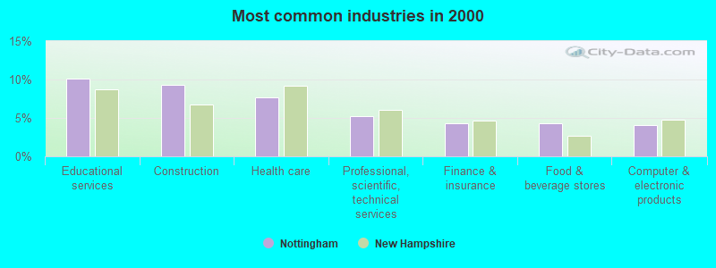
- Educational services (10.1%)
- Construction (9.3%)
- Health care (7.7%)
- Professional, scientific, technical services (5.3%)
- Finance & insurance (4.3%)
- Food & beverage stores (4.3%)
- Computer & electronic products (4.0%)
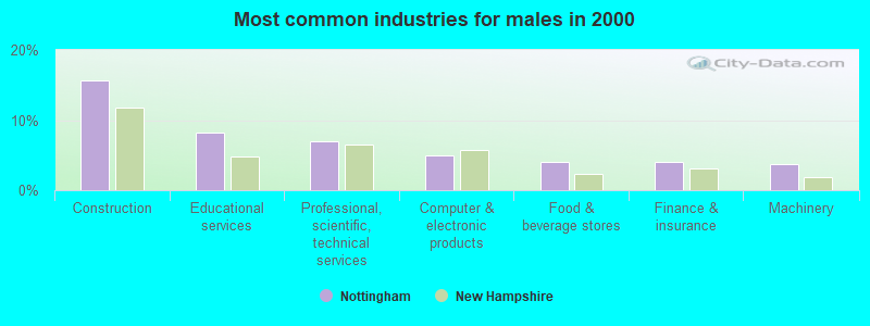
- Construction (15.7%)
- Educational services (8.3%)
- Professional, scientific, technical services (6.9%)
- Computer & electronic products (4.9%)
- Food & beverage stores (4.0%)
- Finance & insurance (4.0%)
- Machinery (3.7%)
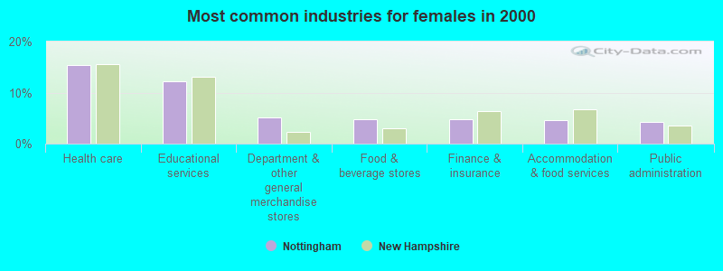
- Health care (15.4%)
- Educational services (12.2%)
- Department & other general merchandise stores (5.2%)
- Food & beverage stores (4.8%)
- Finance & insurance (4.8%)
- Accommodation & food services (4.6%)
- Public administration (4.2%)
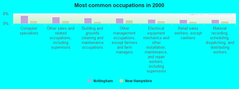
- Computer specialists (6.5%)
- Other sales and related occupations, including supervisors (5.3%)
- Building and grounds cleaning and maintenance occupations (4.6%)
- Other management occupations, except farmers and farm managers (4.3%)
- Electrical equipment mechanics and other installation, maintenance, and repair workers, including supervisors (3.4%)
- Retail sales workers, except cashiers (3.2%)
- Material recording, scheduling, dispatching, and distributing workers (3.1%)
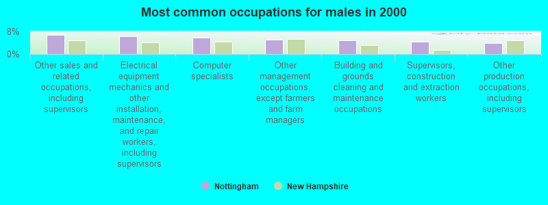
- Other sales and related occupations, including supervisors (6.9%)
- Electrical equipment mechanics and other installation, maintenance, and repair workers, including supervisors (6.3%)
- Computer specialists (5.9%)
- Other management occupations, except farmers and farm managers (5.2%)
- Building and grounds cleaning and maintenance occupations (4.7%)
- Supervisors, construction and extraction workers (4.3%)
- Other production occupations, including supervisors (3.9%)
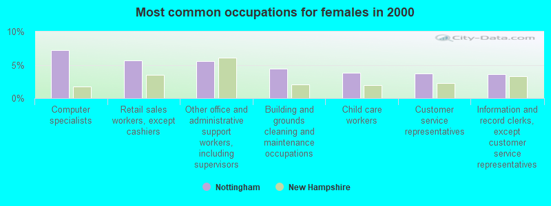
- Computer specialists (7.2%)
- Retail sales workers, except cashiers (5.7%)
- Other office and administrative support workers, including supervisors (5.6%)
- Building and grounds cleaning and maintenance occupations (4.5%)
- Child care workers (3.8%)
- Customer service representatives (3.7%)
- Information and record clerks, except customer service representatives (3.6%)
Average climate in Nottingham, New Hampshire
Based on data reported by over 4,000 weather stations


(lower is better)
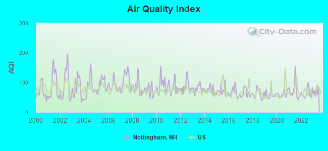
Air Quality Index (AQI) level in 2022 was 65.5. This is about average.
| City: | 65.5 |
| U.S.: | 72.6 |
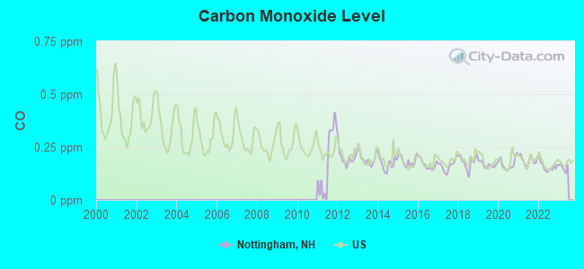
Carbon Monoxide (CO) [ppm] level in 2022 was 0.157. This is significantly better than average. Closest monitor was 18.1 miles away from the city center.
| City: | 0.157 |
| U.S.: | 0.251 |
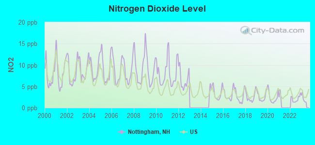
Nitrogen Dioxide (NO2) [ppb] level in 2022 was 2.05. This is significantly better than average. Closest monitor was 9.6 miles away from the city center.
| City: | 2.05 |
| U.S.: | 5.11 |
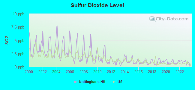
Sulfur Dioxide (SO2) [ppb] level in 2022 was 1.03. This is significantly better than average. Closest monitor was 12.9 miles away from the city center.
| City: | 1.03 |
| U.S.: | 1.51 |
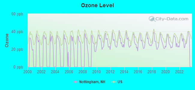
Ozone [ppb] level in 2022 was 29.5. This is about average. Closest monitor was 6.3 miles away from the city center.
| City: | 29.5 |
| U.S.: | 33.3 |
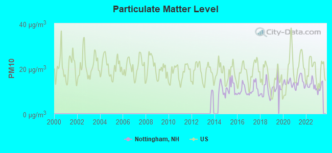
Particulate Matter (PM10) [µg/m3] level in 2022 was 12.8. This is significantly better than average. Closest monitor was 12.9 miles away from the city center.
| City: | 12.8 |
| U.S.: | 19.2 |
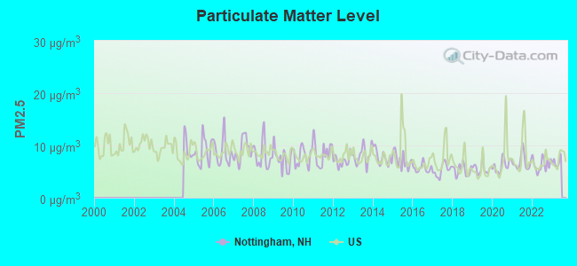
Particulate Matter (PM2.5) [µg/m3] level in 2022 was 6.32. This is better than average. Closest monitor was 18.0 miles away from the city center.
| City: | 6.32 |
| U.S.: | 8.11 |
Tornado activity:
Nottingham-area historical tornado activity is near New Hampshire state average. It is 50% smaller than the overall U.S. average.
On 6/9/1953, a category F3 (max. wind speeds 158-206 mph) tornado 12.9 miles away from the Nottingham town center injured 5 people and caused between $5000 and $50,000 in damages.
On 9/29/1974, a category F3 tornado 35.1 miles away from the town center injured one person and caused between $50,000 and $500,000 in damages.
Earthquake activity:
Nottingham-area historical earthquake activity is significantly above New Hampshire state average. It is 72% smaller than the overall U.S. average.On 4/20/2002 at 10:50:47, a magnitude 5.3 (5.3 ML, Depth: 3.0 mi, Class: Moderate, Intensity: VI - VII) earthquake occurred 160.8 miles away from Nottingham center
On 1/19/1982 at 00:14:42, a magnitude 4.7 (4.5 MB, 4.7 MD, 4.5 LG, Class: Light, Intensity: IV - V) earthquake occurred 35.8 miles away from Nottingham center
On 10/16/2012 at 23:12:25, a magnitude 4.7 (4.7 ML, Depth: 10.0 mi) earthquake occurred 40.0 miles away from Nottingham center
On 10/7/1983 at 10:18:46, a magnitude 5.3 (5.1 MB, 5.3 LG, 5.1 ML) earthquake occurred 171.8 miles away from the city center
On 4/20/2002 at 10:50:47, a magnitude 5.2 (5.2 MB, 4.2 MS, 5.2 MW, 5.0 MW) earthquake occurred 160.6 miles away from the city center
On 8/21/1996 at 07:54:14, a magnitude 3.8 (3.8 LG, 3.6 LG, Depth: 6.2 mi, Class: Light, Intensity: II - III) earthquake occurred 74.3 miles away from the city center
Magnitude types: regional Lg-wave magnitude (LG), body-wave magnitude (MB), duration magnitude (MD), local magnitude (ML), surface-wave magnitude (MS), moment magnitude (MW)
Natural disasters:
The number of natural disasters in Rockingham County (26) is a lot greater than the US average (15).Major Disasters (Presidential) Declared: 17
Emergencies Declared: 9
Causes of natural disasters: Storms: 12, Floods: 9, Winter Storms: 5, Hurricanes: 4, Snowstorms: 4, Snows: 2, Winds: 2, Blizzard: 1, Snowfall: 1, Tornado: 1 (Note: some incidents may be assigned to more than one category).

Hospitals and medical centers near Nottingham:
- ROCKINGHAM COUNTY NURSING HOME (Nursing Home, about 9 miles away; BRENTWOOD, NH)
- COLONIAL POPLIN NURSING HOME (Nursing Home, about 10 miles away; FREMONT, NH)
- RIVERSIDE REST HOME (Nursing Home, about 12 miles away; DOVER, NH)
- ROCKINGHAM VNA AND HOSPICE (Home Health Center, about 13 miles away; EXETER, NH)
- RIVERWOODS AT EXETER (Nursing Home, about 13 miles away; EXETER, NH)
- KINDRED TRANSITIONAL CARE AND REHABILITATION-DOVER (Nursing Home, about 13 miles away; DOVER, NH)
- WENTWORTH HOME CARE AND HOSPICE, AN AMEDISYS PARTNER (Home Health Center, about 14 miles away; DOVER, NH)
Airports located in Nottingham:
- Murphy-Sherwood Park Airport (NH43) (Runways: 1)
Colleges/universities with over 2000 students nearest to Nottingham:
- University of New Hampshire-Main Campus (about 10 miles; Durham, NH; Full-time enrollment: 15,243)
- Southern New Hampshire University (about 19 miles; Manchester, NH; FT enrollment: 16,552)
- Mount Washington College (about 21 miles; Manchester, NH; FT enrollment: 2,187)
- Saint Anselm College (about 23 miles; Manchester, NH; FT enrollment: 2,059)
- NHTI-Concord's Community College (about 23 miles; Concord, NH; FT enrollment: 2,865)
- Northern Essex Community College (about 23 miles; Haverhill, MA; FT enrollment: 4,737)
- Merrimack College (about 32 miles; North Andover, MA; FT enrollment: 2,734)
Public elementary/middle school in Nottingham:
- NOTTINGHAM ELEMENTARY SCHOOL (Students: 515, Location: 245 STAGE RD., Grades: KG-8)
Points of interest:
Notable location: Nottingham Fire Department (A). Display/hide its location on the map
Church in Nottingham: Nottingham Community Church (A). Display/hide its location on the map
Cemeteries: Gove Cemetery (1), South Side Cemetery (2). Display/hide their locations on the map
Lakes, reservoirs, and swamps: Cedar Waters (A), Cyrus Pond (B), Davis Pond (C), Demeritt Pond (D), Kenison Pond (E), Langley Pond (F), Mountain Pond (G), Mulligan Ponds (H). Display/hide their locations on the map
Streams, rivers, and creeks: Mountain Brook (A), Mile Brook (B), Back Creek (C), Bean River (D). Display/hide their locations on the map
Park in Nottingham: Pawtuckaway State Reservation (1). Display/hide its location on the map
Tourist attraction: Abaco Paradise (P.O. Box 278 23 Stevens Hill Rd.) (1). Display/hide its approximate location on the map
Birthplace of: Jonathan Cilley - Politician, Joseph Cilley (senator) - Politician, Bradbury Cilley - Politician, Jason LeHoullier - Boxer.
| This town: | 2.8 people |
| New Hampshire: | 2.5 people |
| This town: | 79.0% |
| Whole state: | 66.3% |
| This town: | 7.7% |
| Whole state: | 8.3% |
Likely homosexual households (counted as self-reported same-sex unmarried-partner households)
- Lesbian couples: 0.9% of all households
- Gay men: 0.5% of all households
| This town: | 2.5% |
| Whole state: | 6.5% |
| This town: | 1.4% |
| Whole state: | 2.8% |
For population 15 years and over in Nottingham:
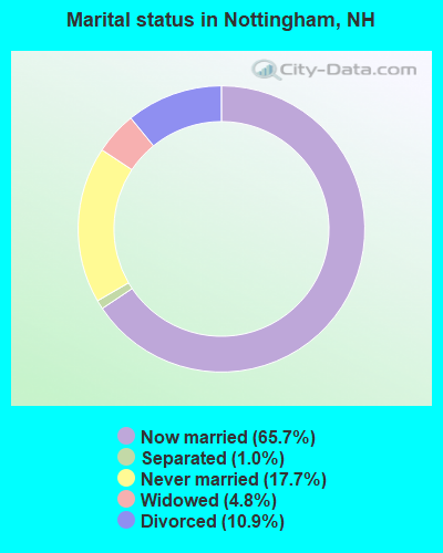
- Never married: 17.7%
- Now married: 65.7%
- Separated: 1.0%
- Widowed: 4.8%
- Divorced: 10.9%
For population 25 years and over in Nottingham:
- High school or higher: 86.3%
- Bachelor's degree or higher: 25.3%
- Graduate or professional degree: 8.5%
- Unemployed: 1.7%
- Mean travel time to work (commute): 33.8 minutes
| Here: | 10.2 |
| New Hampshire average: | 10.9 |


Graphs represent county-level data. Detailed 2008 Election Results
Religion statistics for Nottingham, NH (based on Rockingham County data)


| Religion | Adherents | Congregations |
|---|---|---|
| Catholic | 84,697 | 24 |
| Mainline Protestant | 19,072 | 78 |
| Evangelical Protestant | 7,456 | 61 |
| Other | 3,490 | 20 |
| Orthodox | 200 | 1 |
| None | 180,308 | - |
Food Environment Statistics:
| This county: | 1.59 / 10,000 pop. |
| New Hampshire: | 2.14 / 10,000 pop. |
| This county: | 0.17 / 10,000 pop. |
| State: | 0.15 / 10,000 pop. |
| Rockingham County: | 1.86 / 10,000 pop. |
| New Hampshire: | 1.78 / 10,000 pop. |
| Rockingham County: | 3.31 / 10,000 pop. |
| New Hampshire: | 4.02 / 10,000 pop. |
| Rockingham County: | 9.56 / 10,000 pop. |
| New Hampshire: | 9.70 / 10,000 pop. |
| Rockingham County: | 7.6% |
| New Hampshire: | 7.6% |
| Here: | 23.3% |
| State: | 24.4% |
| Rockingham County: | 16.8% |
| New Hampshire: | 15.9% |
7.69% of this county's 2021 resident taxpayers lived in other counties in 2020 ($114,534 average adjusted gross income)
| Here: | 7.69% |
| New Hampshire average: | 7.66% |
0.01% of residents moved from foreign countries ($203 average AGI)
Rockingham County: 0.01% New Hampshire average: 0.01%
Top counties from which taxpayers relocated into this county between 2020 and 2021:
| from Essex County, MA | |
| from Hillsborough County, NH | |
| from Middlesex County, MA |
6.82% of this county's 2020 resident taxpayers moved to other counties in 2021 ($88,778 average adjusted gross income)
| Here: | 6.82% |
| New Hampshire average: | 6.80% |
0.01% of residents moved to foreign countries ($126 average AGI)
Rockingham County: 0.01% New Hampshire average: 0.01%
Top counties to which taxpayers relocated from this county between 2020 and 2021:
| to Hillsborough County, NH | |
| to Strafford County, NH | |
| to Essex County, MA |
Strongest AM radio stations in Nottingham:
- WGIN (930 AM; 10 kW; ROCHESTER, NH; Owner: CAPSTAR TX LIMITED PARTNERSHIP)
- WRKO (680 AM; 50 kW; BOSTON, MA; Owner: ENTERCOM BOSTON LICENSE, LLC)
- WTSN (1270 AM; 5 kW; DOVER, NH; Owner: GARRISON CITY BROADCASTING, INC.)
- WGIP (1540 AM; 5 kW; EXETER, NH; Owner: CAPSTAR TX LIMITED PARTNERSHIP)
- WDER (1320 AM; 10 kW; DERRY, NH; Owner: BLOUNT COMMUNICATIONS, INC. OF NH)
- WGIR (610 AM; 5 kW; MANCHESTER, NH; Owner: CAPSTAR TX LIMITED PARTNERSHIP)
- WEEI (850 AM; 50 kW; BOSTON, MA; Owner: ENTERCOM BOSTON LICENSE, LLC)
- WBZ (1030 AM; 50 kW; BOSTON, MA; Owner: INFINITY BROADCASTING OPERATIONS, INC.)
- WWZN (1510 AM; 50 kW; BOSTON, MA; Owner: ROSE CITY RADIO CORPORATION)
- WKOX (1200 AM; 50 kW; FRAMINGHAM, MA; Owner: CAPSTAR TX LIMITED PARTNERSHIP)
- WCRN (830 AM; 50 kW; WORCESTER, MA; Owner: CARTER BROADCASTING CORPORATION)
- WBIX (1060 AM; 40 kW; NATICK, MA; Owner: LANGER BROADCASTING CORPORATION)
- WKBR (1250 AM; 5 kW; MANCHESTER, NH; Owner: DEVON BROADCASTING COMPANY, INC.)
Strongest FM radio stations in Nottingham:
- WOKQ (97.5 FM; DOVER, NH; Owner: CITADEL BROADCASTING COMPANY)
- WMEX (106.5 FM; FARMINGTON, NH; Owner: WIMMEX, LLC)
- WUNH (91.3 FM; DURHAM, NH; Owner: UNIVERSITY OF NEW HAMPSHIRE)
- WGIR-FM (101.1 FM; MANCHESTER, NH; Owner: CAPSTAR TX LIMITED PARTNERSHIP)
- WSCY (106.9 FM; MOULTONBOROUGH, NH; Owner: NORTHEAST COMMUNICATIONS CORPORATION)
- WQLL (96.5 FM; BEDFORD, NH; Owner: SAGA COMMUNICATIONS OF NEW ENGLAND, LLC)
- WLMW (90.7 FM; MANCHESTER, NH; Owner: KNOWLEDGE FOR LIFE)
- WZID (95.7 FM; MANCHESTER, NH; Owner: SAGA COMMUNICATIONS OF NEW ENGLAND, LLC)
- W282AF (104.3 FM; CONCORD, NH; Owner: CONCORD BIBLE FELLOWSHIP)
- WNHI (93.3 FM; BELMONT, NH; Owner: CONCORD BROADCASTING, L.L.C.)
- WPKQ (103.7 FM; NORTH CONWAY, NH; Owner: CITADEL BROADCASTING COMPANY)
- WHOM (94.9 FM; MT. WASHINGTON, NH; Owner: CITADEL BROADCASTING COMPANY)
- WERZ (107.1 FM; EXETER, NH; Owner: CAPSTAR TX LIMITED PARTNERSHIP)
- WUBB (95.3 FM; YORK CENTER, ME; Owner: CAPSTAR TX LIMITED PARTNERSHIP)
- WLKZ (104.9 FM; WOLFEBORO, NH; Owner: TELE-MEDIA COMPANY OF NEW HAMPSHIRE, L.L.C.)
- WXRV (92.5 FM; HAVERHILL, MA; Owner: BEANPOT BROADCASTING CORP.)
- WBYY (98.7 FM; SOMERSWORTH, NH; Owner: GARRISON CITY BROADCASTING, INC.)
- WHEB (100.3 FM; PORTSMOUTH, NH; Owner: CAPSTAR TX LIMITED PARTNERSHIP)
- WQSO (96.7 FM; ROCHESTER, NH; Owner: CAPSTAR TX LIMITED PARTNERSHIP)
- WFEX (92.1 FM; PETERBOROUGH, NH; Owner: FNX BROADCASTING OF NEW HAMPSHIRE LLC)
TV broadcast stations around Nottingham:
- WENH-TV (Channel 11; DURHAM, NH; Owner: UNIVERSITY OF NEW HAMPSHIRE)
- WMEA-TV (Channel 26; BIDDEFORD, ME; Owner: MAINE PUBLIC BROADCASTING CORP.)
- WHDN-LP (Channel 26; BOSTON, MA; Owner: GUENTER MARKSTEINER)
- WPXG (Channel 21; CONCORD, NH; Owner: PAXSON BOSTON-68 LICENSE, INC.)
- WFXZ-CA (Channel 24; BOSTON, MA; Owner: BOSTON BROADCASTING CORP.)
- WMTW-TV (Channel 8; POLAND SPRING, ME; Owner: WMTW BROADCAST GROUP, LLC)
- WNDS (Channel 50; DERRY, NH; Owner: CTV OF DERRY, INC)
- National Bridge Inventory (NBI) Statistics
- 7Number of bridges
- 16ft / 5.1mTotal length
- $21,994,000Total costs
- 13,983Total average daily traffic
- 793Total average daily truck traffic
- 20,692Total future (year 2042) average daily traffic
FCC Registered Cell Phone Towers:
1 (See the full list of FCC Registered Cell Phone Towers in Nottingham)FCC Registered Antenna Towers:
7 (See the full list of FCC Registered Antenna Towers)FCC Registered Broadcast Land Mobile Towers:
3- Pawtuckaway Lookout Sta (Lat: 43.102306 Lon: -71.180889), Type: Bant, Structure height: 11 m, Call Sign: KEX288,
Assigned Frequencies: 31.9000 MHz, Grant Date: 08/23/2022, Expiration Date: 11/18/2032, Registrant: Nh Dncr, 172 Pembroke Road, Concord, NH 03301, Phone: (603) 271-2654, Fax: (603) 271-6488, Email:
- Police Dept Rt 152 (Lat: 43.174250 Lon: -71.141167), Call Sign: KVJ622,
Assigned Frequencies: 155.475 MHz, 156.090 MHz, Grant Date: 04/27/2022, Expiration Date: 07/09/2032, Registrant: Nh Dept. Of Safety/Emergency Services And Communications, 33 Hazen Dr (Mailing), Concord, NH 03305, Phone: (603) 528-7541, Fax: (603) 271-6629, Email:
- Lat: 43.147222 Lon: -71.110556, Call Sign: WQKW674,
Assigned Frequencies: 464.225 MHz, 463.425 MHz, 463.775 MHz, Grant Date: 07/23/2019, Expiration Date: 10/08/2029, Certifier: Michelle L Carvallio, Registrant: Federal License Management, 175 Pine St, Suite 104, Williamsport, PA 17701-6549, Phone: (866) 908-2220, Fax: (570) 323-4002, Email:
FCC Registered Amateur Radio Licenses:
31 (See the full list of FCC Registered Amateur Radio Licenses in Nottingham)FAA Registered Aircraft:
4- Aircraft: CESSNA 172F (Category: Land, Seats: 4, Weight: Up to 12,499 Pounds, Speed: 105 mph), Engine: CONT MOTOR 0-300 SER (145 HP) (Reciprocating)
N-Number: 5305R, N5305R, N-5305R, Serial Number: 17252827, Year manufactured: 1965, Airworthiness Date: 04/02/1965, Certificate Issue Date: 02/25/2004
Registrant (Individual): Larry Woodman, 22 Gebig Rd, Nottingham, NH 03290 - Aircraft: PIPER PA-28-140 (Category: Land, Seats: 4, Weight: Up to 12,499 Pounds, Speed: 107 mph), Engine: LYCOMING 0-320 SERIES (180 HP) (Reciprocating)
N-Number: 5605U, N5605U, N-5605U, Serial Number: 28-26534, Year manufactured: 1969, Airworthiness Date: 10/23/1969, Certificate Issue Date: 07/02/2014
Registrant (LLC): N5605u LLC, 10 Sofia Way, Nottingham, NH 03290 - Aircraft: PIPER PA-28-140 (Category: Land, Seats: 4, Weight: Up to 12,499 Pounds, Speed: 107 mph), Engine: LYCOMING 0-320 SERIES (180 HP) (Reciprocating)
N-Number: 6681W, N6681W, N-6681W, Serial Number: 28-20789, Year manufactured: 1965, Airworthiness Date: 04/14/1965, Certificate Issue Date: 11/18/2019
Registrant (Individual): Hope I Batchelder-Roach, 324 Stage Rd, Nottingham, NH 03290 - Aircraft: CIRRUS DESIGN CORP SR20 (Category: Land, Seats: 4, Weight: Up to 12,499 Pounds), Engine: CONT MOTOR IO-360-ES (210 HP) (Reciprocating)
N-Number: 7789T, N7789T, N-7789T, Serial Number: 1989, Year manufactured: 2008, Airworthiness Date: 05/14/2008, Certificate Issue Date: 12/29/2017
Registrant (Individual): Terry L Bonser, 24 Smoke St, Nottingham, NH 03290
2002 - 2018 National Fire Incident Reporting System (NFIRS) incidents
- Fire incident types reported to NFIRS in Nottingham, NH
- 18858.8%Structure Fires
- 7724.1%Outside Fires
- 3410.6%Mobile Property/Vehicle Fires
- 216.6%Other
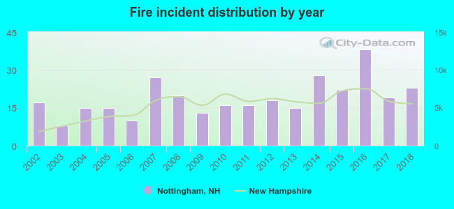 Based on the data from the years 2002 - 2018 the average number of fire incidents per year is 19. The highest number of fires - 38 took place in 2016, and the least - 8 in 2003. The data has an increasing trend.
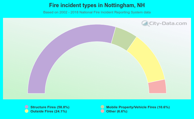 When looking into fire subcategories, the most reports belonged to: Structure Fires (58.8%), and Outside Fires (24.1%).
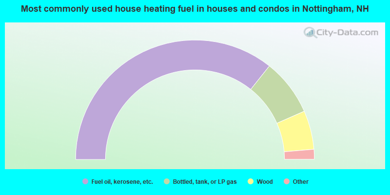
- 71.4%Fuel oil, kerosene, etc.
- 15.4%Bottled, tank, or LP gas
- 10.5%Wood
- 1.6%Electricity
- 1.2%Utility gas
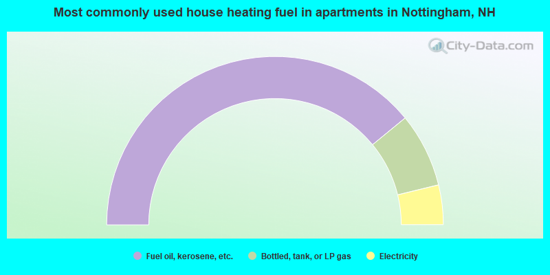
- 78.2%Fuel oil, kerosene, etc.
- 14.3%Bottled, tank, or LP gas
- 7.6%Electricity
Nottingham compared to New Hampshire state average:
- Unemployed percentage significantly below state average.
- Black race population percentage below state average.
- Hispanic race population percentage significantly below state average.
- Foreign-born population percentage significantly below state average.
- Renting percentage significantly below state average.
- Length of stay since moving in significantly above state average.
- Number of rooms per house significantly below state average.
- House age significantly below state average.

|
|
Total of 115 patent applications in 2008-2024.