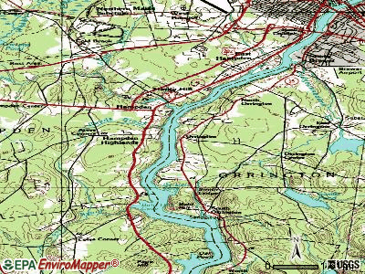
Orrington, Maine
Submit your own pictures of this town and show them to the world
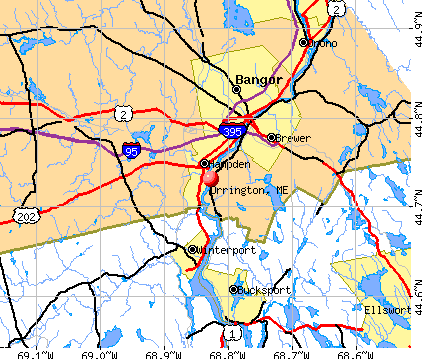
- OSM Map
- General Map
- Google Map
- MSN Map
Population change since 2000: +5.9%
 |
| Males: 1,851 | |
| Females: 1,882 |
| Median resident age: | 43.5 years |
| Maine median age: | 43.0 years |
Zip codes: 04474.
| Orrington: | $79,065 |
| ME: | $69,543 |
Estimated per capita income in 2022: $38,778 (it was $19,290 in 2000)
Orrington town income, earnings, and wages data
Estimated median house or condo value in 2022: $244,594 (it was $94,000 in 2000)
| Orrington: | $244,594 |
| ME: | $290,600 |
Mean prices in 2022: all housing units: $235,563; detached houses: $252,705; townhouses or other attached units: $267,749; in 2-unit structures: $255,332; in 3-to-4-unit structures: $815,300; in 5-or-more-unit structures: $185,873; mobile homes: $93,017; occupied boats, rvs, vans, etc.: $21,333
Detailed information about poverty and poor residents in Orrington, ME
Compare current foreclosures near Orrington, ME:
| Photo | Address | Area | Beds / Baths | Price | Details |
|---|---|---|---|---|---|

|
#1
Pleasant Hill Ln
Orrington, ME 04474
|
- sq. feet
|
- baths - beds |
show details | |

|
#2
Mount Ephraim Rd
Searsport, ME 04974
|
1,972 sq. feet
|
2 baths 4 beds |
$154,900
|
show details |

|
#3
Union St
Bangor, ME 04401
|
1,512 sq. feet
|
2 baths 6 beds |
$54,900
|
show details |

|
#4
Surry Rd
Orland, ME 04472
|
- sq. feet
|
4 baths 5 beds |
$174,900
|
show details |

|
#5
Maxwell Ln
Bangor, ME 04401
|
1,750 sq. feet
|
2 baths 3 beds |
show details | |

|
#6
Western Ave
Hampden, ME 04444
|
1,976 sq. feet
|
2 baths 4 beds |
show details | |

|
#7
Highland Ave
Bangor, ME 04401
|
3,348 sq. feet
|
1 baths 5 beds |
show details | |

|
#8
Kenduskeag Levant Rd
Kenduskeag, ME 04450
|
- sq. feet
|
2 baths 3 beds |
show details | |

|
#9
Ichabod Ln
Hampden, ME 04444
|
960 sq. feet
|
1 baths 3 beds |
show details | |

|
#10
Rd
Brewer, ME 04412
|
2,428 sq. feet
|
1 baths 4 beds |
show details |
| Photo | Address | Area | Beds / Baths | Price | Details |
|---|---|---|---|---|---|

|
#11
Western Ave
Hampden, ME 04444
|
1,825 sq. feet
|
1 baths 3 beds |
show details | |

|
#12
Grove St
Bangor, ME 04401
|
910 sq. feet
|
1 baths 3 beds |
show details | |

|
#13
Lancaster Ave
Bangor, ME 04401
|
324 sq. feet
|
1 baths 1 beds |
show details | |

|
#14
Allen St
Bangor, ME 04401
|
1,200 sq. feet
|
1 baths 3 beds |
show details | |

|
#15
Bennoch Rd
Old Town, ME 04468
|
- sq. feet
|
- baths - beds |
show details | |

|
#16
Loop Rd
Searsport, ME 04974
|
- sq. feet
|
- baths - beds |
show details | |

|
#17
Summer St
Old Town, ME 04468
|
- sq. feet
|
- baths - beds |
show details | |

|
#18
Muskrat Farm Rd
Stockton Springs, ME 04981
|
- sq. feet
|
- baths - beds |
show details | |

|
#19
Broadway
Kenduskeag, ME 04450
|
- sq. feet
|
- baths - beds |
show details | |

|
#20
Front Ridge Rd
Penobscot, ME 04476
|
- sq. feet
|
- baths - beds |
show details |
| Photo | Address | Area | Beds / Baths | Price | Details |
|---|---|---|---|---|---|

|
#21
Harris Rd Apt 31
Orono, ME 04473
|
- sq. feet
|
- baths - beds |
show details | |

|
#22
Mechanic St
Bucksport, ME 04416
|
- sq. feet
|
- baths - beds |
show details | |

|
#23
Hampden Rd
Carmel, ME 04419
|
- sq. feet
|
- baths - beds |
show details | |

|
#24
Indian Hill Ln
Frankfort, ME 04438
|
- sq. feet
|
- baths - beds |
show details | |

|
#25
Baker Blvd Ste 205
Brewer, ME 04412
|
- sq. feet
|
- baths - beds |
show details | |

|
#26
Smokey Ln
Bangor, ME 04401
|
- sq. feet
|
- baths - beds |
show details | |

|
#27
Pine St # B
Bangor, ME 04401
|
- sq. feet
|
- baths - beds |
show details | |

|
#28
Cedar St Apt 4
Bangor, ME 04401
|
- sq. feet
|
- baths - beds |
show details | |

|
#29
Aa Landing Rd
Bangor, ME 04401
|
- sq. feet
|
- baths - beds |
show details | |

|
#30
Gott Brook Hts
Orland, ME 04472
|
- sq. feet
|
- baths - beds |
show details |
| Photo | Address | Area | Beds / Baths | Price | Details |
|---|---|---|---|---|---|

|
#31
Merrill Rd
Eddington, ME 04428
|
- sq. feet
|
- baths - beds |
show details | |
|
|
#32
York Rd
Bangor, ME 04401
|
- sq. feet
|
- baths - beds |
show details | |

|
#33
Central St
Bucksport, ME 04416
|
- sq. feet
|
- baths - beds |
show details | |

|
#34
Kenduskeag Ave # 24
Bangor, ME 04401
|
- sq. feet
|
- baths - beds |
show details | |

|
#35
South Rd
Brewer, ME 04412
|
- sq. feet
|
- baths - beds |
show details | |

|
#36
Cedar Breeze N
Bangor, ME 04401
|
- sq. feet
|
- baths - beds |
show details | |

|
Check over 1 million property listings on Foreclosure.com!
|
browse all offers | |||

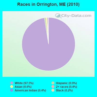
- 3,63997.5%White alone
- 350.9%Hispanic
- 210.6%Asian alone
- 140.4%American Indian alone
- 160.4%Two or more races
- 70.2%Black alone
- 10.03%Native Hawaiian and Other
Pacific Islander alone
Races in Orrington detailed stats: ancestries, foreign born residents, place of birth
According to our research of Maine and other state lists, there were 9 registered sex offenders living in Orrington, Maine as of April 23, 2024.
The ratio of all residents to sex offenders in Orrington is 415 to 1.
The ratio of registered sex offenders to all residents in this city is near the state average.
 Recent articles from our blog. Our writers, many of them Ph.D. graduates or candidates, create easy-to-read articles on a wide variety of topics.

 | Orrington v Veazie (maybe Brewer) Elementary schools and more! (0 replies) |
| Looking to move outside Bangor with kids (6 replies) |
| Potential Move to Bangor (14 replies) |
| Where to live? (21 replies) |
| Orrington, Maine (14 replies) |
| Re - Locating back to Maine (13 replies) |
Latest news from Orrington, ME collected exclusively by city-data.com from local newspapers, TV, and radio stations
Ancestries: English (18.1%), French (14.6%), Irish (12.8%), United States (9.5%), German (8.3%), French Canadian (6.9%).
Current Local Time: EST time zone
Incorporated on 03/21/1788
Elevation: 140 feet
Land area: 25.4 square miles.
Population density: 147 people per square mile (very low).
81 residents are foreign born (1.4% North America, 0.8% Europe).
| This town: | 2.3% |
| Maine: | 2.9% |
| Orrington town: | 1.3% ($1,198) |
| Maine: | 1.5% ($1,417) |
Nearest city with pop. 50,000+: Portland, ME  (103.6 miles , pop. 64,249).
Nearest city with pop. 200,000+: Boston, MA (202.1 miles , pop. 589,141).
Nearest city with pop. 1,000,000+: Bronx, NY (371.9 miles , pop. 1,332,650).
Nearest cities:
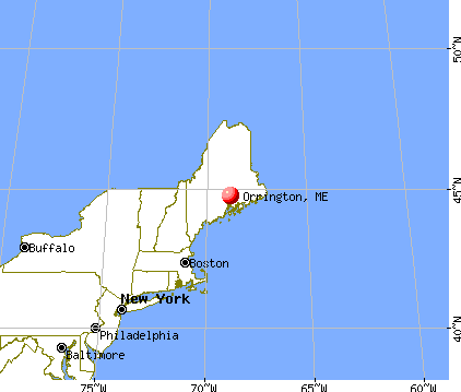
), ), ), )Latitude: 44.72 N, Longitude: 68.79 W
Area code: 207

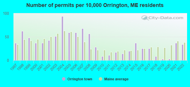
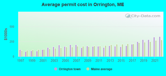
Single-family new house construction building permits:
- 2022: 12 buildings, average cost: $332,300
- 2021: 13 buildings, average cost: $325,000
- 2020: 1 building, cost: $282,200
- 2019: 1 building, cost: $282,200
- 2018: 3 buildings, average cost: $249,800
- 2017: 9 buildings, average cost: $207,000
- 2016: 9 buildings, average cost: $182,800
- 2015: 13 buildings, average cost: $164,900
- 2014: 7 buildings, average cost: $173,400
- 2013: 5 buildings, average cost: $182,000
- 2012: 6 buildings, average cost: $151,900
- 2011: 4 buildings, average cost: $174,200
- 2010: 3 buildings, average cost: $169,200
- 2009: 10 buildings, average cost: $179,100
- 2008: 20 buildings, average cost: $148,300
- 2007: 24 buildings, average cost: $200,000
- 2006: 21 buildings, average cost: $200,000
- 2005: 21 buildings, average cost: $166,700
- 2004: 33 buildings, average cost: $193,400
- 2003: 18 buildings, average cost: $163,100
- 2002: 15 buildings, average cost: $150,000
- 2001: 13 buildings, average cost: $120,000
- 2000: 13 buildings, average cost: $92,000
- 1999: 17 buildings, average cost: $96,100
- 1998: 22 buildings, average cost: $83,900
- 1997: 13 buildings, average cost: $119,300
| Here: | 2.3% |
| Maine: | 3.4% |
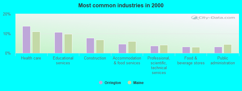
- Health care (13.7%)
- Educational services (10.6%)
- Construction (7.7%)
- Accommodation & food services (4.6%)
- Professional, scientific, technical services (3.8%)
- Food & beverage stores (3.3%)
- Public administration (3.2%)
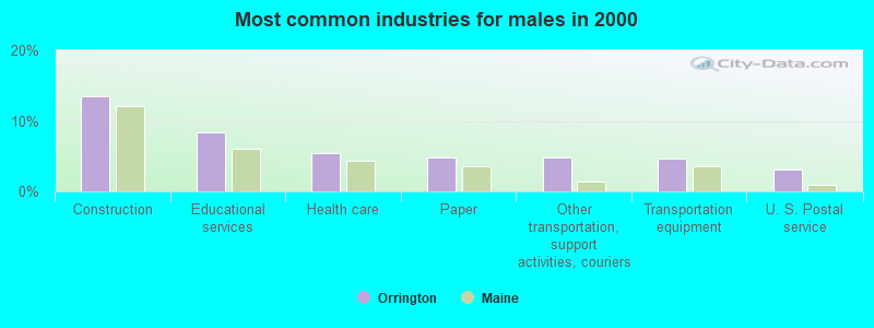
- Construction (13.5%)
- Educational services (8.3%)
- Health care (5.4%)
- Paper (4.9%)
- Other transportation, support activities, couriers (4.9%)
- Transportation equipment (4.6%)
- U. S. Postal service (3.1%)
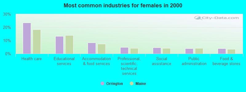
- Health care (23.5%)
- Educational services (13.3%)
- Accommodation & food services (8.3%)
- Professional, scientific, technical services (4.8%)
- Social assistance (4.6%)
- Public administration (4.0%)
- Food & beverage stores (3.9%)
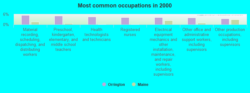
- Material recording, scheduling, dispatching, and distributing workers (5.4%)
- Preschool, kindergarten, elementary, and middle school teachers (5.2%)
- Health technologists and technicians (4.6%)
- Registered nurses (4.3%)
- Electrical equipment mechanics and other installation, maintenance, and repair workers, including supervisors (4.2%)
- Other office and administrative support workers, including supervisors (4.1%)
- Other production occupations, including supervisors (3.5%)
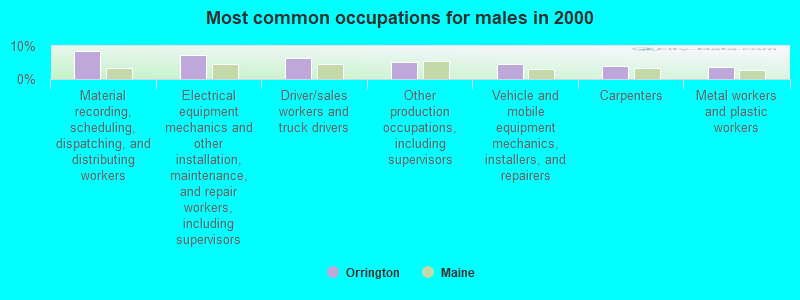
- Material recording, scheduling, dispatching, and distributing workers (8.5%)
- Electrical equipment mechanics and other installation, maintenance, and repair workers, including supervisors (7.3%)
- Driver/sales workers and truck drivers (6.4%)
- Other production occupations, including supervisors (5.1%)
- Vehicle and mobile equipment mechanics, installers, and repairers (4.7%)
- Carpenters (3.8%)
- Metal workers and plastic workers (3.6%)

- Health technologists and technicians (8.6%)
- Registered nurses (8.0%)
- Preschool, kindergarten, elementary, and middle school teachers (7.9%)
- Other office and administrative support workers, including supervisors (7.6%)
- Other sales and related occupations, including supervisors (4.4%)
- Secretaries and administrative assistants (4.4%)
- Retail sales workers, except cashiers (4.3%)
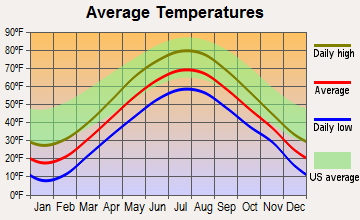
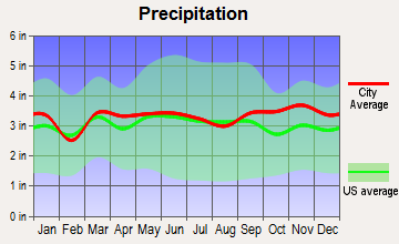
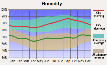
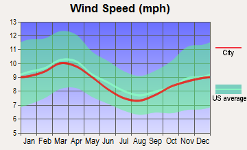
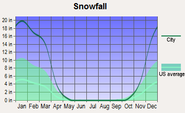
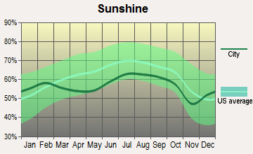
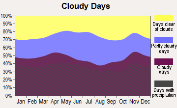
Average climate in Orrington, Maine
Based on data reported by over 4,000 weather stations
(lower is better)
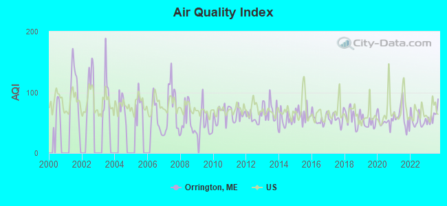
Air Quality Index (AQI) level in 2023 was 61.1. This is about average.
| City: | 61.1 |
| U.S.: | 72.6 |
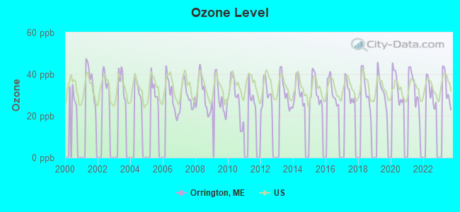
Ozone [ppb] level in 2023 was 33.6. This is about average. Closest monitor was 1.2 miles away from the city center.
| City: | 33.6 |
| U.S.: | 33.3 |
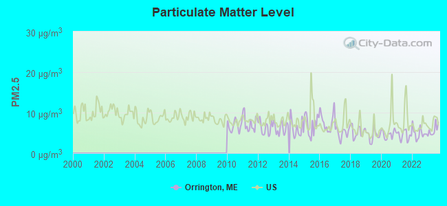
Particulate Matter (PM2.5) [µg/m3] level in 2023 was 5.62. This is significantly better than average. Closest monitor was 5.4 miles away from the city center.
| City: | 5.62 |
| U.S.: | 8.11 |
Earthquake activity:
Orrington-area historical earthquake activity is significantly above Maine state average. It is 81% smaller than the overall U.S. average.On 10/16/2012 at 23:12:25, a magnitude 4.7 (4.7 ML, Depth: 10.0 mi, Class: Light, Intensity: IV - V) earthquake occurred 120.9 miles away from Orrington center
On 4/20/2002 at 10:50:47, a magnitude 5.3 (5.3 ML, Depth: 3.0 mi, Class: Moderate, Intensity: VI - VII) earthquake occurred 242.1 miles away from Orrington center
On 4/20/2002 at 10:50:47, a magnitude 5.2 (5.2 MB, 4.2 MS, 5.2 MW, 5.0 MW) earthquake occurred 243.2 miles away from Orrington center
On 1/19/1982 at 00:14:42, a magnitude 4.7 (4.5 MB, 4.7 MD, 4.5 LG) earthquake occurred 163.2 miles away from Orrington center
On 10/7/1983 at 10:18:46, a magnitude 5.3 (5.1 MB, 5.3 LG, 5.1 ML) earthquake occurred 279.7 miles away from Orrington center
On 2/26/1999 at 03:38:43, a magnitude 3.8 (3.8 LG, Depth: 2.0 mi, Class: Light, Intensity: II - III) earthquake occurred 39.7 miles away from the city center
Magnitude types: regional Lg-wave magnitude (LG), body-wave magnitude (MB), duration magnitude (MD), local magnitude (ML), surface-wave magnitude (MS), moment magnitude (MW)
Natural disasters:
The number of natural disasters in Penobscot County (19) is greater than the US average (15).Major Disasters (Presidential) Declared: 11
Emergencies Declared: 7
Causes of natural disasters: Floods: 9, Storms: 8, Snows: 5, Heavy Rains: 2, Blizzard: 1, Hurricane: 1, Ice Storm: 1, Snowfall: 1, Wind: 1, Winter Storm: 1, Other: 2 (Note: some incidents may be assigned to more than one category).
Hospitals and medical centers near Orrington:
- KINDRED TRANSITIONAL CARE AND REHAB-BREWER (Nursing Home, about 5 miles away; BREWER, ME)
- ST JOSEPH HOSPICE (Hospital, about 6 miles away; BANGOR, ME)
- ST JOSEPH HOSPITAL Acute Care Hospitals (about 6 miles away; BANGOR, ME)
- AMEDISYS HOME HEALTH OF BANGOR (Home Health Center, about 6 miles away; BANGOR, ME)
- GENTIVA HEALTH SERVICES (Home Health Center, about 6 miles away; BANGOR, ME)
- CHANDLER BAY HOME HEALTH AGENCY INC (Home Health Center, about 6 miles away; BANGOR, ME)
- BANGOR NURSING AND REHABILITATION (Nursing Home, about 6 miles away; BANGOR, ME)
Colleges/universities with over 2000 students nearest to Orrington:
- Husson University (about 8 miles; Bangor, ME; Full-time enrollment: 2,421)
- University of Maine (about 14 miles; Orono, ME; FT enrollment: 8,931)
- University of Maine at Augusta (about 57 miles; Augusta, ME; FT enrollment: 3,204)
- University of Maine at Farmington (about 67 miles; Farmington, ME; FT enrollment: 2,036)
- Southern Maine Community College (about 104 miles; South Portland, ME; FT enrollment: 4,666)
- University of Southern Maine (about 104 miles; Portland, ME; FT enrollment: 6,647)
- Saint Joseph's College of Maine (about 105 miles; Standish, ME; FT enrollment: 2,010)
Private high school in Orrington:
Public elementary/middle schools in Orrington:
- CENTER DRIVE SCHOOL (Students: 388, Location: 19 SCHOOL STREET, Grades: PK-8)
- DEDHAM SCHOOL (Students: 161, Location: 19 SCHOOL STREET, Grades: PK-8)
Points of interest:
Notable locations in Orrington: Fields Pond Settlement (A), Orrington Fire and Rescue (B). Display/hide their locations on the map
Church in Orrington: East Orrington Congregational Church (A). Display/hide its location on the map
Cemeteries: North Orrington Cemetery (1), Pine Hill Cemetery (2), Village Cemetery (3). Display/hide their locations on the map
Lakes and reservoirs: Trout Pond (A), Fields Pond (B), Swetts Pond (C), Brewer Lake (D). Display/hide their locations on the map
Creek: Mill Creek (A). Display/hide its location on the map
Birthplace of: Benjamin Franklin Mudge - Geologist.
Drinking water stations with addresses in Orrington and their reported violations in the past:
CENTER DRIVE SCHOOL (Population served: 400, Groundwater):Past health violations:DEDHAM ELEMENTARY SCHOOL (Population served: 212, Groundwater):Past monitoring violations:
- MCL, Monthly (TCR) - In SEP-2013, Contaminant: Coliform. Follow-up actions: St Public Notif requested (SEP-20-2013), St Formal NOV issued (SEP-20-2013), St Public Notif received (OCT-03-2013)
- MCL, Monthly (TCR) - In JUL-2009, Contaminant: Coliform. Follow-up actions: St Public Notif requested (AUG-05-2009), St Formal NOV issued (AUG-05-2009), St Public Notif received (AUG-24-2009), St Compliance achieved (SEP-06-2011), St Intentional no-action (SEP-09-2011)
- Follow-up Or Routine LCR Tap M/R - In JUL-10-2003, Contaminant: Lead and Copper Rule. Follow-up actions: St Public Notif requested (DEC-19-2005), St Violation/Reminder Notice (DEC-19-2005), St Compliance achieved (DEC-21-2005), St Public Notif received (DEC-21-2005)
- 3 routine major monitoring violations
Past health violations:ROCKY KNOLL SERVICES (Population served: 144, Groundwater):Past monitoring violations:
- OCCT/SOWT Study/Recommendation - In FEB-11-2006, Contaminant: Lead and Copper Rule. Follow-up actions: St Violation/Reminder Notice (JUL-13-2006), St Compliance achieved (AUG-15-2006)
- 3 routine major monitoring violations
- 49 regular monitoring violations
Past health violations:TRENTON HEALTH CENTER (Population served: 77, Groundwater):Past monitoring violations:
- MCL, Monthly (TCR) - In NOV-2010, Contaminant: Coliform. Follow-up actions: St Public Notif requested (NOV-22-2010), St Formal NOV issued (NOV-22-2010), St Compliance achieved (DEC-28-2010), St Public Notif received (JAN-04-2011)
- 4 routine major monitoring violations
Past health violations:CLOSE TO HOME CHILDCARE (Population served: 25, Groundwater):
- MCL, Monthly (TCR) - In SEP-2011, Contaminant: Coliform. Follow-up actions: St Public Notif requested (SEP-30-2011), St Formal NOV issued (SEP-30-2011), St Public Notif received (OCT-07-2011), St Compliance achieved (NOV-09-2011)
Past health violations:Past monitoring violations:
- MCL, Monthly (TCR) - In JAN-2014, Contaminant: Coliform. Follow-up actions: St Formal NOV issued (JAN-27-2014), St Public Notif requested (JAN-27-2014), St Compliance achieved (FEB-20-2014), St Public Notif received (APR-01-2014)
- 2 routine major monitoring violations
| This town: | 2.5 people |
| Maine: | 2.3 people |
| This town: | 72.3% |
| Whole state: | 62.9% |
| This town: | 8.1% |
| Whole state: | 9.4% |
Likely homosexual households (counted as self-reported same-sex unmarried-partner households)
- Lesbian couples: 0.7% of all households
- Gay men: 0.3% of all households
| This town: | 4.3% |
| Whole state: | 10.9% |
| This town: | 2.2% |
| Whole state: | 4.1% |
Banks with branches in Orrington (2011 data):
- People's United Bank: Orrington Branch at Route 15, branch established on 1999/11/08. Info updated 2012/02/16: Bank assets: $27,319.3 mil, Deposits: $20,835.4 mil, headquarters in Bridgeport, CT, positive income, Commercial Lending Specialization, 374 total offices
For population 15 years and over in Orrington:
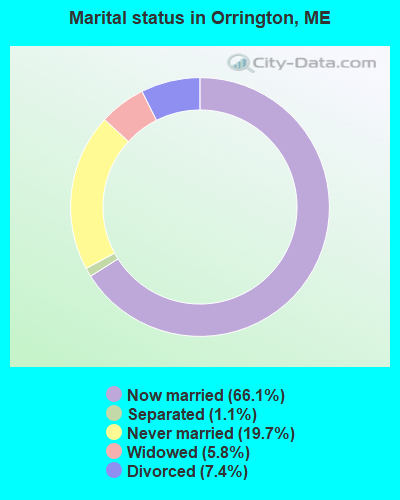
- Never married: 19.7%
- Now married: 66.1%
- Separated: 1.1%
- Widowed: 5.8%
- Divorced: 7.4%
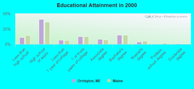
For population 25 years and over in Orrington:
- High school or higher: 89.0%
- Bachelor's degree or higher: 20.5%
- Graduate or professional degree: 5.3%
- Unemployed: 3.3%
- Mean travel time to work (commute): 19.4 minutes
| Here: | 9.9 |
| Maine average: | 11.2 |


Graphs represent county-level data. Detailed 2008 Election Results
Religion statistics for Orrington, ME (based on Penobscot County data)


| Religion | Adherents | Congregations |
|---|---|---|
| Catholic | 16,581 | 15 |
| Mainline Protestant | 9,715 | 59 |
| Evangelical Protestant | 7,523 | 80 |
| Other | 2,936 | 22 |
| Orthodox | 300 | 1 |
| None | 116,868 | - |
Food Environment Statistics:
| Penobscot County: | 2.29 / 10,000 pop. |
| Maine: | 2.80 / 10,000 pop. |
| This county: | 0.13 / 10,000 pop. |
| Maine: | 0.14 / 10,000 pop. |
| This county: | 2.56 / 10,000 pop. |
| Maine: | 2.20 / 10,000 pop. |
| Penobscot County: | 5.72 / 10,000 pop. |
| Maine: | 5.75 / 10,000 pop. |
| This county: | 7.41 / 10,000 pop. |
| State: | 11.02 / 10,000 pop. |
| Penobscot County: | 9.0% |
| Maine: | 8.2% |
| Penobscot County: | 28.0% |
| Maine: | 25.0% |
Businesses in Orrington, ME
- Circle K: 1
- Dunkin Donuts: 1
Strongest AM radio stations in Orrington:
- WABI (910 AM; 5 kW; BANGOR, ME; Owner: CLEAR CHANNEL BROADCASTING LICENSES, INC.)
- WZON (620 AM; 5 kW; BANGOR, ME; Owner: THE ZONE CORPORATION)
- WNZS (1340 AM; 1 kW; VEAZIE, ME; Owner: WATERFRONT COMMUNICATIONS INC.)
- WDEA (1370 AM; 5 kW; ELLSWORTH, ME; Owner: CUMULUS LICENSING CORP.)
- WSKW (1160 AM; 10 kW; SKOWHEGAN, ME; Owner: MOUNTAIN WIRELESS, INCORPORATED)
- WRKO (680 AM; 50 kW; BOSTON, MA; Owner: ENTERCOM BOSTON LICENSE, LLC)
- WTME (780 AM; 10 kW; RUMFORD, ME; Owner: MOUNTAIN VALLEY BROADCASTING, INC.)
- WEEI (850 AM; 50 kW; BOSTON, MA; Owner: ENTERCOM BOSTON LICENSE, LLC)
- WBZ (1030 AM; 50 kW; BOSTON, MA; Owner: INFINITY BROADCASTING OPERATIONS, INC.)
- WFAU (1280 AM; 5 kW; GARDINER, ME; Owner: CAPSTAR TX LIMITED PARTNERSHIP)
- WCRN (830 AM; 50 kW; WORCESTER, MA; Owner: CARTER BROADCASTING CORPORATION)
- WNNZ (640 AM; 50 kW; WESTFIELD, MA; Owner: CLEAR CHANNEL BROADCASTING LICENSES, INC.)
- WKOX (1200 AM; 50 kW; FRAMINGHAM, MA; Owner: CAPSTAR TX LIMITED PARTNERSHIP)
Strongest FM radio stations in Orrington:
- WKIT-FM (100.3 FM; BREWER, ME; Owner: THE ZONE CORPORATION)
- WWMJ (95.7 FM; ELLSWORTH, ME; Owner: CUMULUS LICENSING CORP.)
- WBFB (104.7 FM; BELFAST, ME; Owner: CLEAR CHANNEL BROADCASTING LICENSES, INC.)
- WWBX (97.1 FM; BANGOR, ME; Owner: CLEAR CHANNEL BROADCASTING LICENSES, INC.)
- WMEH (90.9 FM; BANGOR, ME; Owner: MAINE PUBLIC BROADCASTING CORPORATION)
- WEZQ (92.9 FM; BANGOR, ME; Owner: CUMULUS LICENSING CORP.)
- WFZX (101.7 FM; SEARSPORT, ME; Owner: CLEAR CHANNEL BROADCASTING LICENSES, INC.)
- WERU-FM (89.9 FM; BLUE HILL, ME; Owner: SALT POND COMMUNITY B/C COMPANY)
- WVOM (103.9 FM; HOWLAND, ME; Owner: CLEAR CHANNEL BROADCASTING LICENSES, INC.)
- WHCF (88.5 FM; BANGOR, ME; Owner: BANGOR BAPTIST CHURCH)
- WQCB (106.5 FM; BREWER, ME; Owner: CUMULUS LICENSING CORP.)
- WBZN (107.3 FM; OLD TOWN, ME; Owner: CUMULUS LICENSING CORP.)
- WMEP (90.5 FM; CAMDEN, ME; Owner: MAINE PUBLIC BROADCASTING CORP.)
- WQSS (102.5 FM; CAMDEN, ME; Owner: CLEAR CHANNEL BROADCASTING LICENSES, INC.)
- WNSX (97.7 FM; WINTER HARBOR, ME; Owner: CLEAR CHANNEL BROADCASTING LICENSES, INC.)
- W275AE (102.9 FM; BANGOR, ME; Owner: SALT POND COMMUNITY BROADCASTING, INC.)
- WGUY (102.1 FM; DEXTER, ME; Owner: CONCORD MEDIA GROUP, INC.)
- WLKE (99.1 FM; BAR HARBOR, ME; Owner: CLEAR CHANNEL BROADCASTING LICENSES, INC.)
- WHSN (89.3 FM; BANGOR, ME; Owner: HUSSON COLLEGE)
- WMEB-FM (91.9 FM; ORONO, ME; Owner: UNIVERSITY OF MAINE SYSTEM)
TV broadcast stations around Orrington:
- WCKD-LP (Channel 30; BANGOR/DEDHAM, ME; Owner: J. MCLEOD, ME FAMILY B/CING., INC.)
- WBGR-LP (Channel 33; BANGOR/DEDHAM, ME; Owner: MAINE FAMILY BROADCASTING, INC.)
- WLBZ (Channel 2; BANGOR, ME; Owner: PACIFIC AND SOUTHERN COMPANY, INC.)
- WABI-TV (Channel 5; BANGOR, ME; Owner: COMMUNITY BROADCASTING SERVICE)
- WMEB-TV (Channel 12; ORONO, ME; Owner: MAINE PUBLIC BROADCASTING CORPORATION)
- W36CK (Channel 36; BANGOR, ME; Owner: TRINITY BROADCASTING NETWORK)
- W66CL (Channel 66; BANGOR, ME; Owner: MS COMMUNICATIONS, LLC)
- WBAN-LP (Channel 9; BANGOR, ME; Owner: BANGOR MEDIA GROUP, LLC)
- WVII-TV (Channel 7; BANGOR, ME; Owner: BANGOR COMMUNICATIONS, INC.)
- WFVX-LP (Channel 22; BANGOR, ME; Owner: ROCKFLEET BROADCASTING III, LLC)
- W39CC (Channel 39; BANGOR, ME; Owner: MS COMMUNICATIONS, LLC)
- W42BZ (Channel 42; BANGOR, ME; Owner: MS COMMUNICATIONS, LLC)
- W50BX (Channel 50; BANGOR, ME; Owner: MS COMMUNICATIONS, LLC)
- W54CG (Channel 54; BANGOR, ME; Owner: MS COMMUNICATIONS, LLC)
- National Bridge Inventory (NBI) Statistics
- 3Number of bridges
- 10ft / 3.1mTotal length
- 7,345Total average daily traffic
- 365Total average daily truck traffic
- 10,490Total future (year 2036) average daily traffic
FCC Registered Antenna Towers:
10 (See the full list of FCC Registered Antenna Towers in Orrington)FCC Registered Broadcast Land Mobile Towers:
1- Lat: 44.400806 Lon: -68.761389, Call Sign: WQGP712,
Assigned Frequencies: 465.912 MHz, Grant Date: 01/13/2017, Expiration Date: 03/19/2027, Certifier: David R Tonini, Registrant: Federal License Management, 1784 E. 3rd Street Suite 269, Williamsport, PA 17701-3862, Phone: (866) 908-2220, Fax: (570) 323-4002, Email:
FCC Registered Microwave Towers:
5- ORRINGTON, 132 Fields Pond Road (Lat: 44.739778 Lon: -68.755028), Type: Mast, Structure height: 24.4 m, Call Sign: WQFU608,
Assigned Frequencies: 6775.00 MHz, 6835.00 MHz, Grant Date: 09/13/2016, Expiration Date: 10/06/2026, Certifier: John Doyon, Registrant: Versant Power, 970 Illinois Avenue, Bangor, ME 04402-0932, Phone: (207) 973-2546, Email:
- KINGS MTN, 1307 Center Drive (Lat: 44.680722 Lon: -68.755889), Type: Ltower, Structure height: 80.4 m, Overall height: 84.1 m, Call Sign: WQFU610,
Assigned Frequencies: 6561.25 MHz, 6565.00 MHz, Grant Date: 09/13/2016, Expiration Date: 10/06/2026, Certifier: John Doyon, Registrant: Versant Power, 970 Illinois Avenue, Bangor, ME 04402-0932, Phone: (207) 973-2546, Email:
- KINGS MTN, 1307 Center Drive (Lat: 44.680722 Lon: -68.755889), Type: Ltower, Structure height: 80.4 m, Overall height: 84.1 m, Call Sign: WQKN853,
Assigned Frequencies: 6655.00 MHz, 6595.00 MHz, 6675.00 MHz, Grant Date: 08/03/2019, Expiration Date: 07/28/2029, Certifier: John Doyon, Registrant: Versant Power, 970 Illinois Avenue, Bangor, ME 04402-0932, Phone: (207) 973-2546, Email:
- KINGS MTN, Kings Mtn Rd South Brewer (Lat: 44.680611 Lon: -68.755583), Overall height: 82 m, Call Sign: KCC85,
Assigned Frequencies: 3970.00 MHz, 4030.00 MHz, 3730.00 MHz, 3730.00 MHz, 3890.00 MHz, 3810.00 MHz, 3810.00 MHz, 3970.00 MHz, 3890.00 MHz, 4050.00 MHz, 4050.00 MHz, 4130.00 MHz, Grant Date: 02/19/1998, Expiration Date: 02/01/2000, Cancellation Date: 05/07/2000, Phone: (404) 810-4021
- STATION, Orrington Substation In East Orrington (Lat: 44.739778 Lon: -68.755028), Overall height: 30.5 m, Call Sign: WDI81,
Assigned Frequencies: 6815.00 MHz, Grant Date: 03/27/2010, Expiration Date: 05/16/2020, Cancellation Date: 04/14/2015, Registrant: Utc Spectrum Services, 200 N. Glebe Road, Suite 1000, Arlington, VA 22203, Phone: (703) 558-2204, Fax: (703) 276-1169, Email:
FCC Registered Amateur Radio Licenses:
32 (See the full list of FCC Registered Amateur Radio Licenses in Orrington)FAA Registered Aircraft:
9 (See the full list of FAA Registered Aircraft in Orrington)2003 - 2018 National Fire Incident Reporting System (NFIRS) incidents
- Fire incident types reported to NFIRS in Orrington, ME
- 21648.1%Structure Fires
- 10824.1%Outside Fires
- 8518.9%Other
- 408.9%Mobile Property/Vehicle Fires
 Based on the data from the years 2003 - 2018 the average number of fire incidents per year is 28. The highest number of reported fires - 51 took place in 2006, and the least - 5 in 2004. The data has a rising trend.
 When looking into fire subcategories, the most reports belonged to: Structure Fires (48.1%), and Outside Fires (24.1%).
- 91.9%Fuel oil, kerosene, etc.
- 5.1%Wood
- 1.8%Bottled, tank, or LP gas
- 1.2%Electricity
- 82.7%Fuel oil, kerosene, etc.
- 13.6%Electricity
- 3.7%Wood
Orrington compared to Maine state average:
- Unemployed percentage significantly below state average.
- Black race population percentage significantly below state average.
- Hispanic race population percentage below state average.
- Foreign-born population percentage below state average.
- Renting percentage below state average.
- Length of stay since moving in significantly above state average.
- Number of rooms per house significantly below state average.
- House age significantly below state average.

|
|
Total of 7 patent applications in 2008-2024.