Pittston, Maine
Submit your own pictures of this town and show them to the world
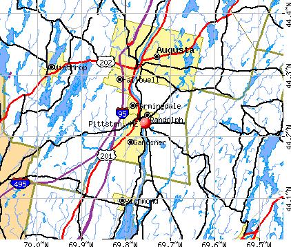
- OSM Map
- General Map
- Google Map
- MSN Map
Population change since 2000: +4.6%
 |
| Males: 1,345 | |
| Females: 1,321 |
| Median resident age: | 44.8 years |
| Maine median age: | 43.0 years |
Zip codes: 04345.
| Pittston: | $68,308 |
| ME: | $69,543 |
Estimated per capita income in 2022: $38,267 (it was $19,059 in 2000)
Pittston town income, earnings, and wages data
Estimated median house or condo value in 2022: $224,279 (it was $82,500 in 2000)
| Pittston: | $224,279 |
| ME: | $290,600 |
Mean prices in 2022: all housing units: $236,573; detached houses: $257,878; townhouses or other attached units: $279,624; in 2-unit structures: $165,218; in 3-to-4-unit structures: $152,679; in 5-or-more-unit structures: $182,239; mobile homes: $91,490
Detailed information about poverty and poor residents in Pittston, ME


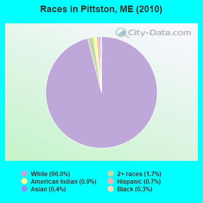
- 2,55996.0%White alone
- 441.7%Two or more races
- 240.9%American Indian alone
- 190.7%Hispanic
- 110.4%Asian alone
- 90.3%Black alone
Races in Pittston detailed stats: ancestries, foreign born residents, place of birth
According to our research of Maine and other state lists, there were 7 registered sex offenders living in Pittston, Maine as of April 19, 2024.
The ratio of all residents to sex offenders in Pittston is 381 to 1.
 Recent articles from our blog. Our writers, many of them Ph.D. graduates or candidates, create easy-to-read articles on a wide variety of topics.

 | Maine weather thread (3207 replies) |
| Maine areas with less ticks and other insects (16 replies) |
| Greenville Vacation in October-Suggestions? (11 replies) |
| The Moody Mansion-Pittston Maine (21 replies) |
| Side X Sides and the Maine trails including summer snow mobile trails (3 replies) |
| Relocating to Maine this spring...looking for suggestions (15 replies) |
Latest news from Pittston, ME collected exclusively by city-data.com from local newspapers, TV, and radio stations
Ancestries: English (25.7%), Irish (16.1%), French (15.5%), United States (8.9%), French Canadian (7.3%), German (6.4%).
Current Local Time: EST time zone
Incorporated on 02/04/1779
Elevation: 73 feet
Land area: 32.2 square miles.
Population density: 83 people per square mile (very low).
43 residents are foreign born
| This town: | 1.7% |
| Maine: | 2.9% |
| Pittston town: | 1.4% ($1,150) |
| Maine: | 1.5% ($1,417) |
Nearest city with pop. 50,000+: Portland, ME  (45.7 miles , pop. 64,249).
Nearest city with pop. 200,000+: Boston, MA (146.6 miles , pop. 589,141).
Nearest city with pop. 1,000,000+: Bronx, NY (313.7 miles , pop. 1,332,650).
Nearest cities:
), ), ), ), ), Latitude: 44.19 N, Longitude: 69.71 W
Area code commonly used in this area: 207

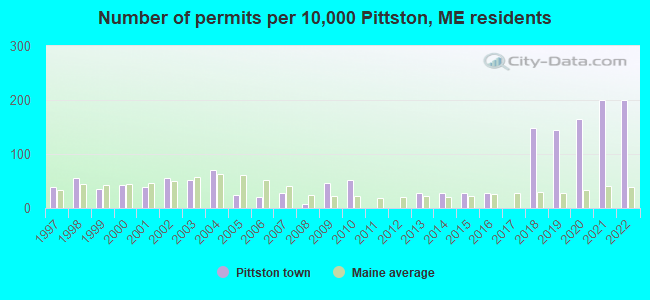
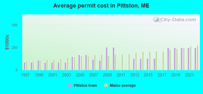
Single-family new house construction building permits:
- 2022: 51 buildings, average cost: $249,800
- 2021: 51 buildings, average cost: $249,800
- 2020: 42 buildings, average cost: $249,800
- 2019: 37 buildings, average cost: $249,800
- 2018: 38 buildings, average cost: $249,800
- 2016: 7 buildings, average cost: $128,600
- 2015: 7 buildings, average cost: $128,600
- 2014: 7 buildings, average cost: $128,600
- 2013: 7 buildings, average cost: $128,600
- 2010: 13 buildings, average cost: $255,000
- 2009: 12 buildings, average cost: $255,000
- 2008: 2 buildings, average cost: $110,000
- 2007: 7 buildings, average cost: $121,400
- 2006: 5 buildings, average cost: $170,800
- 2005: 6 buildings, average cost: $170,800
- 2004: 18 buildings, average cost: $150,000
- 2003: 13 buildings, average cost: $87,000
- 2002: 14 buildings, average cost: $87,000
- 2001: 10 buildings, average cost: $87,300
- 2000: 11 buildings, average cost: $84,900
- 1999: 9 buildings, average cost: $109,200
- 1998: 14 buildings, average cost: $85,700
- 1997: 10 buildings, average cost: $85,500
| Here: | 2.4% |
| Maine: | 3.4% |
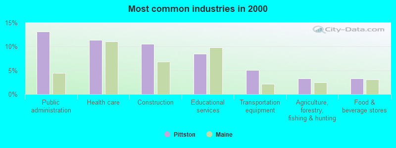
- Public administration (13.1%)
- Health care (11.4%)
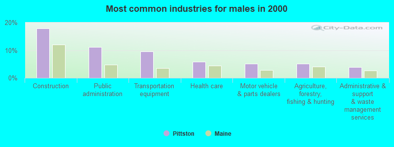
- Construction (10.5%)
- Educational services (8.5%)
- Transportation equipment (5.0%)
- Agriculture, forestry, fishing & hunting (3.3%)
- Food & beverage stores (3.3%)
- Construction (17.9%)
- Public administration (11.1%)
- Transportation equipment (9.6%)
- Health care (5.9%)
- Motor vehicle & parts dealers (5.2%)
- Agriculture, forestry, fishing & hunting (5.1%)
- Administrative & support & waste management services (3.8%)
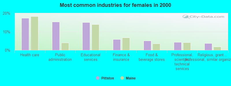
- Health care (17.4%)
- Public administration (15.4%)
- Educational services (15.0%)
- Finance & insurance (6.0%)
- Food & beverage stores (5.2%)
- Professional, scientific, technical services (4.4%)
- Religious, grantmaking, civic, professional, similar organizations (3.8%)

- Other office and administrative support workers, including supervisors (5.1%)
- Other production occupations, including supervisors (5.0%)
- Secretaries and administrative assistants (4.3%)
- Driver/sales workers and truck drivers (3.8%)
- Material recording, scheduling, dispatching, and distributing workers (3.6%)
- Building and grounds cleaning and maintenance occupations (3.6%)
- Other sales and related occupations, including supervisors (3.4%)
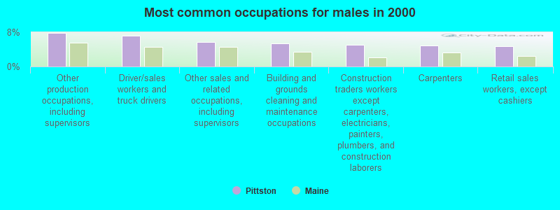
- Other production occupations, including supervisors (7.8%)
- Driver/sales workers and truck drivers (7.2%)
- Other sales and related occupations, including supervisors (5.8%)
- Building and grounds cleaning and maintenance occupations (5.4%)
- Construction traders workers except carpenters, electricians, painters, plumbers, and construction laborers (5.1%)
- Carpenters (4.9%)
- Retail sales workers, except cashiers (4.8%)
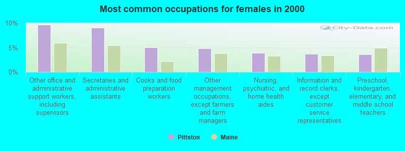
- Other office and administrative support workers, including supervisors (9.7%)
- Secretaries and administrative assistants (9.1%)
- Cooks and food preparation workers (5.0%)
- Other management occupations, except farmers and farm managers (4.9%)
- Nursing, psychiatric, and home health aides (3.9%)
- Information and record clerks, except customer service representatives (3.8%)
- Preschool, kindergarten, elementary, and middle school teachers (3.6%)
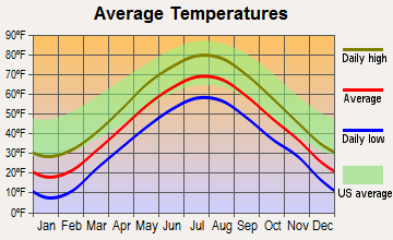
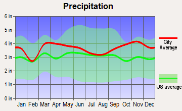
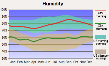
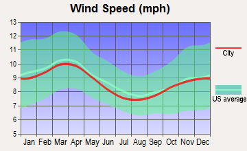
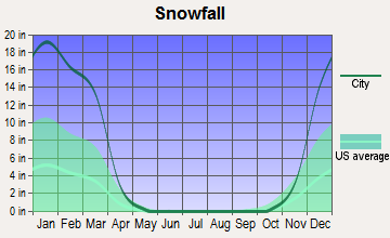
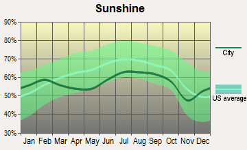
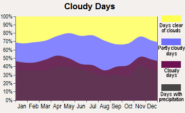
Average climate in Pittston, Maine
Based on data reported by over 4,000 weather stations
(lower is better)
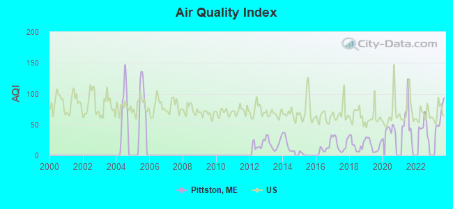
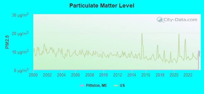
Air Quality Index (AQI) level in 2023 was 62.3. This is about average.
| City: | 62.3 |
| U.S.: | 72.6 |
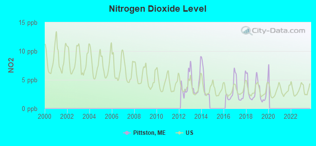
Nitrogen Dioxide (NO2) [ppb] level in 2019 was 2.80. This is significantly better than average. Closest monitor was 4.6 miles away from the city center.
| City: | 2.80 |
| U.S.: | 5.11 |
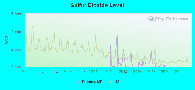
Sulfur Dioxide (SO2) [ppb] level in 2019 was 0.185. This is significantly better than average. Closest monitor was 4.6 miles away from the city center.
| City: | 0.185 |
| U.S.: | 1.515 |
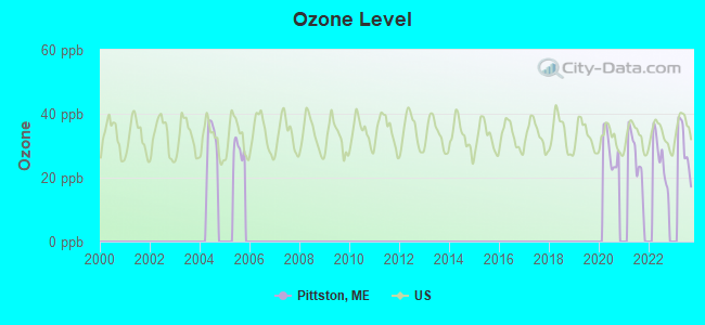
Ozone [ppb] level in 2023 was 29.5. This is about average. Closest monitor was 4.6 miles away from the city center.
| City: | 29.5 |
| U.S.: | 33.3 |
Earthquake activity:
Pittston-area historical earthquake activity is significantly above Maine state average. It is 77% smaller than the overall U.S. average.On 10/16/2012 at 23:12:25, a magnitude 4.7 (4.7 ML, Depth: 10.0 mi, Class: Light, Intensity: IV - V) earthquake occurred 62.4 miles away from the city center
On 4/20/2002 at 10:50:47, a magnitude 5.3 (5.3 ML, Depth: 3.0 mi, Class: Moderate, Intensity: VI - VII) earthquake occurred 198.4 miles away from Pittston center
On 4/20/2002 at 10:50:47, a magnitude 5.2 (5.2 MB, 4.2 MS, 5.2 MW, 5.0 MW) earthquake occurred 199.2 miles away from Pittston center
On 1/19/1982 at 00:14:42, a magnitude 4.7 (4.5 MB, 4.7 MD, 4.5 LG) earthquake occurred 105.6 miles away from the city center
On 10/7/1983 at 10:18:46, a magnitude 5.3 (5.1 MB, 5.3 LG, 5.1 ML) earthquake occurred 230.6 miles away from the city center
On 2/26/1999 at 03:38:43, a magnitude 3.8 (3.8 LG, Depth: 2.0 mi, Class: Light, Intensity: II - III) earthquake occurred 22.2 miles away from Pittston center
Magnitude types: regional Lg-wave magnitude (LG), body-wave magnitude (MB), duration magnitude (MD), local magnitude (ML), surface-wave magnitude (MS), moment magnitude (MW)
Natural disasters:
The number of natural disasters in Kennebec County (21) is greater than the US average (15).Major Disasters (Presidential) Declared: 16
Emergencies Declared: 4
Causes of natural disasters: Floods: 13, Storms: 11, Snows: 5, Hurricanes: 3, Heavy Rains: 2, Blizzard: 1, Ice Storm: 1, Snowfall: 1, Wind: 1, Other: 2 (Note: some incidents may be assigned to more than one category).
Hospitals and medical centers near Pittston:
- MAINEGENERAL MEDICAL CENTER -GARDINER (Nursing Home, about 4 miles away; GARDINER, ME)
- MERRILL MEMORIAL MANOR (Nursing Home, about 4 miles away; GARDINER, ME)
- ROBINSON HLTH CARE FAC (Nursing Home, about 4 miles away; GARDINER, ME)
- SUPPORTIVE LIVING SYSTEMS INC (Home Health Center, about 8 miles away; AUGUSTA, ME)
- MAINE VETERANS HOME - AUGUSTA (Nursing Home, about 8 miles away; AUGUSTA, ME)
- MAINE GENERAL REHAB AND NURSING AT GLENRIDGE (Nursing Home, about 9 miles away; AUGUSTA, ME)
- KINDRED TRANSITIONAL CARE AND REHAB-AUGUSTA (Nursing Home, about 9 miles away; AUGUSTA, ME)
Colleges/universities with over 2000 students nearest to Pittston:
- University of Maine at Augusta (about 12 miles; Augusta, ME; Full-time enrollment: 3,204)
- University of Maine at Farmington (about 40 miles; Farmington, ME; FT enrollment: 2,036)
- Southern Maine Community College (about 46 miles; South Portland, ME; FT enrollment: 4,666)
- Saint Joseph's College of Maine (about 46 miles; Standish, ME; FT enrollment: 2,010)
- University of Southern Maine (about 47 miles; Portland, ME; FT enrollment: 6,647)
- University of New England (about 61 miles; Biddeford, ME; FT enrollment: 4,539)
- Husson University (about 64 miles; Bangor, ME; FT enrollment: 2,421)
Public elementary/middle school in Pittston:
- PITTSTON CONSOLIDATED SCHOOL (Location: 1023 SCHOOL STREET, Grades: KG-5)
Points of interest:
Notable locations in Pittston: Pittston Fire Department Substation (A), Pittston Fire Department Central Station (B). Display/hide their locations on the map
Cemeteries: Putnam Cemetery (1), Maple Grove Cemetery (2), Goodspeed Cemetery (3), Riverside Cemetery (4), Coss Hill Cemetery (5). Display/hide their locations on the map
Lakes: Joys Pond (A), Jays Pond (B), Nehumkeag Pond (C). Display/hide their locations on the map
Streams, rivers, and creeks: Stony Meadow Brook (A), West Branch Eastern River (B), Palmer Brook (C), Kimball Brook (D), East Branch Eastern River (E), Morton Brook (F). Display/hide their locations on the map
Birthplace of: Daniel T. Jewett - Politician.
Drinking water stations with addresses in Pittston and their reported violations in the past:
CAMP PHOENIX (Population served: 52, Groundwater):Past health violations:
- MCL, Monthly (TCR) - In MAY-2009, Contaminant: Coliform. Follow-up actions: St Public Notif requested (JUN-05-2009), St Formal NOV issued (JUN-05-2009), St Public Notif received (JUN-23-2009), St Compliance achieved (SEP-07-2011), St Intentional no-action (SEP-09-2011)
Drinking water stations with addresses in Pittston that have no violations reported:
- EAST PITTSTON WATER DISTRICT (Population served: 53, Primary Water Source Type: Groundwater)
- KENNEBEC VIEW PARK (Population served: 50, Primary Water Source Type: Groundwater)
- LAKEWOOD COMM WATER ASSOC (Population served: 42, Primary Water Source Type: Groundwater)
| This town: | 2.4 people |
| Maine: | 2.3 people |
| This town: | 68.7% |
| Whole state: | 62.9% |
| This town: | 10.5% |
| Whole state: | 9.4% |
Likely homosexual households (counted as self-reported same-sex unmarried-partner households)
- Lesbian couples: 0.3% of all households
- Gay men: 0.1% of all households
| This town: | 7.3% |
| Whole state: | 10.9% |
| This town: | 2.0% |
| Whole state: | 4.1% |
For population 15 years and over in Pittston:
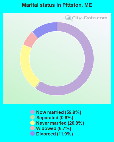
- Never married: 20.8%
- Now married: 59.9%
- Separated: 0.6%
- Widowed: 6.7%
- Divorced: 11.9%
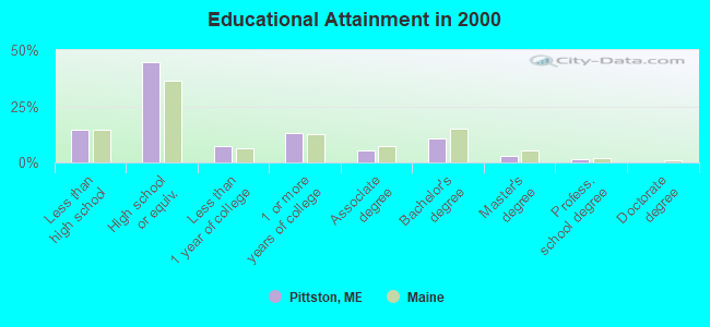
For population 25 years and over in Pittston:
- High school or higher: 85.5%
- Bachelor's degree or higher: 14.9%
- Graduate or professional degree: 4.4%
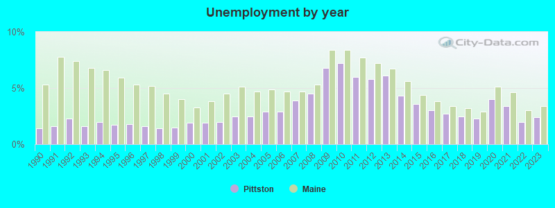
- Unemployed: 3.9%
- Mean travel time to work (commute): 25.6 minutes
| Here: | 9.6 |
| Maine average: | 11.2 |
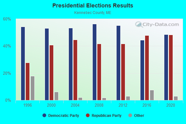
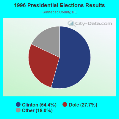
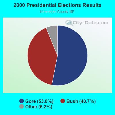
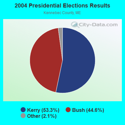
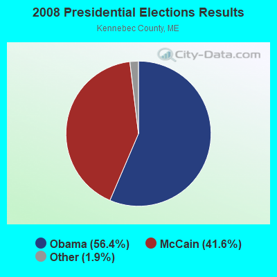
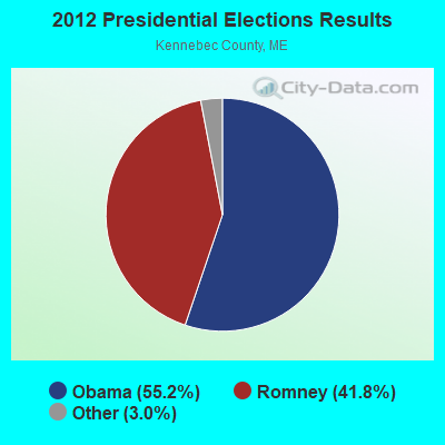

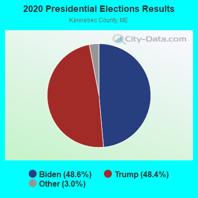
Graphs represent county-level data. Detailed 2008 Election Results
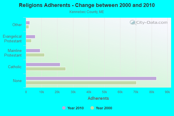
Religion statistics for Pittston, ME (based on Kennebec County data)
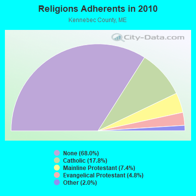
| Religion | Adherents | Congregations |
|---|---|---|
| Catholic | 21,758 | 11 |
| Mainline Protestant | 8,999 | 60 |
| Evangelical Protestant | 5,829 | 56 |
| Other | 2,466 | 17 |
| None | 83,099 | - |
Food Environment Statistics:
| Kennebec County: | 1.99 / 10,000 pop. |
| Maine: | 2.80 / 10,000 pop. |
| Kennebec County: | 0.17 / 10,000 pop. |
| State: | 0.14 / 10,000 pop. |
| Kennebec County: | 1.41 / 10,000 pop. |
| Maine: | 2.20 / 10,000 pop. |
| Kennebec County: | 6.38 / 10,000 pop. |
| State: | 5.75 / 10,000 pop. |
| Kennebec County: | 8.70 / 10,000 pop. |
| State: | 11.02 / 10,000 pop. |
| Here: | 8.6% |
| State: | 8.2% |
| Kennebec County: | 28.2% |
| State: | 25.0% |
Strongest AM radio stations in Pittston:
- WFAU (1280 AM; 5 kW; GARDINER, ME; Owner: CAPSTAR TX LIMITED PARTNERSHIP)
- WEZW (1400 AM; 1 kW; AUGUSTA, ME; Owner: CITADEL BROADCASTING COMPANY)
- WMDR (1340 AM; 1 kW; AUGUSTA, ME; Owner: LIGHT OF LIFE MINISTRIES, INC.)
- WTME (780 AM; 10 kW; RUMFORD, ME; Owner: MOUNTAIN VALLEY BROADCASTING, INC.)
- WSKW (1160 AM; 10 kW; SKOWHEGAN, ME; Owner: MOUNTAIN WIRELESS, INCORPORATED)
- WLAM (1470 AM; 5 kW; LEWISTON, ME; Owner: RADIO PARTNERS OF MAINE, L.P.)
- WMTW (870 AM; 10 kW; GORHAM, ME; Owner: RADIO PARTNERS OF MAINE, L.P.)
- WGAN (560 AM; 5 kW; PORTLAND, ME; Owner: SAGA COMMUNICATIONS OF NEW ENGLAND, LLC)
- WRKO (680 AM; 50 kW; BOSTON, MA; Owner: ENTERCOM BOSTON LICENSE, LLC)
- WJTO (730 AM; 1 kW; BATH, ME; Owner: BLUE JEY BROADCASTING COMPANY)
- WEEI (850 AM; 50 kW; BOSTON, MA; Owner: ENTERCOM BOSTON LICENSE, LLC)
- WBZ (1030 AM; 50 kW; BOSTON, MA; Owner: INFINITY BROADCASTING OPERATIONS, INC.)
- WJJB (900 AM; 1 kW; BRUNSWICK, ME; Owner: ATLANTIC COAST RADIO, LLC)
Strongest FM radio stations in Pittston:
- WMME-FM (92.3 FM; AUGUSTA, ME; Owner: CITADEL BROADCASTING COMPANY)
- WABK-FM (104.3 FM; GARDINER, ME; Owner: CAPSTAR TX LIMITED PARTNERSHIP)
- WCYI (93.9 FM; LEWISTON, ME; Owner: CITADEL BROADCASTING COMPANY)
- WBCI (105.9 FM; BATH, ME; Owner: BLOUNT COMMUNICATIONS, INC.)
- WMEP (90.5 FM; CAMDEN, ME; Owner: MAINE PUBLIC BROADCASTING CORP.)
- WQSS (102.5 FM; CAMDEN, ME; Owner: CLEAR CHANNEL BROADCASTING LICENSES, INC.)
- WKCG (101.3 FM; AUGUSTA, ME; Owner: CAPSTAR TX LIMITED PARTNERSHIP)
- WCME (96.7 FM; BOOTHBAY HARBOR, ME; Owner: CAPSTAR TX LIMITED PARTNERSHIP)
- WWWA (95.3 FM; WINSLOW, ME; Owner: LIGHT OF LIFE MINISTRIES, INC.)
- WPKQ (103.7 FM; NORTH CONWAY, NH; Owner: CITADEL BROADCASTING COMPANY)
- WHOM (94.9 FM; MT. WASHINGTON, NH; Owner: CITADEL BROADCASTING COMPANY)
- WBLM (102.9 FM; PORTLAND, ME; Owner: CITADEL BROADCASTING COMPANY)
- WTOS-FM (105.1 FM; SKOWHEGAN, ME; Owner: CAPSTAR TX LIMITED PARTNERSHIP)
- WMEA (90.1 FM; PORTLAND, ME; Owner: MAINE PUBLIC BROADCASTING CORPORATION)
- WMCM (103.3 FM; ROCKLAND, ME; Owner: CLEAR CHANNEL BROADCASTING LICENSES, INC.)
- WTHT (107.5 FM; LEWISTON, ME; Owner: RADIO PARTNERS OF MAINE, L.P.)
- WCLZ (98.9 FM; BRUNSWICK, ME; Owner: CITADEL BROADCASTING COMPANY)
- WLOB-FM (96.3 FM; RUMFORD, ME; Owner: ATLANTIC COAST RADIO, LLC)
- WBQX (106.9 FM; THOMASTON, ME; Owner: MARINER BROADCASTING LIMITED PARTNER)
- WWBX (97.1 FM; BANGOR, ME; Owner: CLEAR CHANNEL BROADCASTING LICENSES, INC.)
TV broadcast stations around Pittston:
- WPFO (Channel 23; WATERVILLE, ME; Owner: CMCG PORTLAND LICENSE LLC)
- WCBB (Channel 10; AUGUSTA, ME; Owner: MAINE PUBLIC BROADCASTING CORP.)
- WGME-TV (Channel 13; PORTLAND, ME; Owner: WGME LICENSEE, LLC)
- WFYW-LP (Channel 69; FAIRFIELD/WATERVILLE, ME; Owner: THREE ANGELS BROADCASTING NETWORK, INC.)
- National Bridge Inventory (NBI) Statistics
- 3Number of bridges
- 7ft / 2.4mTotal length
- 12,461Total average daily traffic
- 621Total average daily truck traffic
- 17,647Total future (year 2036) average daily traffic
FCC Registered Cell Phone Towers:
1- Located At Mckee Construction (Lat: 44.222250 Lon: -69.753694), Type: Tower, Structure height: 30.5 m, Overall height: 36 m, Call Sign: KNKN667
Assigned Frequencies: 869.040 MHz, 824.040 MHz, 890.010 MHz, 845.010 MHzGrant Date: 09/09/2020, Expiration Date: 10/01/2030Registrant: Wilkinson Barker Knauer, LLP, 1800 M Street Nw, Suite 800n, Washington, DC 20036, Phone: (202) 383-3420, Fax: (202) 783-5851, Email:
FCC Registered Broadcast Land Mobile Towers:
3- 3/4 Mi N Dresden Line On Rt 27 (Lat: 44.145917 Lon: -69.745889), Call Sign: WNPE420, Licensee ID: L00051933,
Assigned Frequencies: 151.835 MHz, Grant Date: 03/26/2004, Expiration Date: 04/24/2014, Cancellation Date: 06/28/2014, Registrant: Sam Snow Construction Inc, Rfd 4 Box 7547, Gardiner, ME 04345, Phone: (207) 582-2135
- FIRE STATION, Pittston Fire Station Rt 126 (Lat: 44.224000 Lon: -69.692500), Type: Bant, Structure height: 4 m, Overall height: 6 m, Call Sign: WQCE886,
Assigned Frequencies: 158.872 MHz, 458.762 MHz, Grant Date: 02/16/2005, Expiration Date: 02/16/2015, Cancellation Date: 04/18/2015, Certifier: Jason A Farris, Registrant: Radio Communications Management, 5 Memorial Circle, Augusta, ME 04330, Phone: (207) 622-2758, Fax: (207) 622-5871, Email:
- Lat: 44.166667 Lon: -69.750000, Call Sign: WQJB344,
Assigned Frequencies: 461.537 MHz, 464.637 MHz, Grant Date: 07/14/2008, Expiration Date: 07/14/2018, Cancellation Date: 09/15/2018, Certifier: Shelly A Simpson, Registrant: Radio Communications Management, Inc., 236 Hallowell Road, Chelsea, ME 04330, Phone: (207) 622-2758, Fax: (207) 622-5871, Email:
FCC Registered Amateur Radio Licenses:
15 (See the full list of FCC Registered Amateur Radio Licenses in Pittston)FAA Registered Aircraft:
4- Aircraft: FIREFLY BALLOONS INC FIREFLY 7B (Category: Land, Weight: Up to 12,499 Pounds), Engine: None
N-Number: 2080C, N2080C, N-2080C, Serial Number: F7B-2013, Year manufactured: 2006, Airworthiness Date: 01/23/2006, Certificate Issue Date: 05/05/2007
Registrant (Individual): Joseph A Caputo, 320 Jewett Rd, Pittston, ME 04345 - Aircraft: BALLOON WORKS FIREFLY 7-B (Category: Land, Weight: Up to 12,499 Pounds), Engine: None
N-Number: 37048, N37048, N-37048, Serial Number: F7B-119, Airworthiness Date: 06/17/1985, Certificate Issue Date: 08/03/1985
Registrant (Individual): Joseph A Caputo, 320 Jewett Rd, Pittston, ME 04345 - Aircraft: SKYRANGER/BEST OFF SKYRANGER II (Category: Land, Seats: 2, Weight: Up to 12,499 Pounds), Engine: ROTAX 912S (100 HP) (4 Cycle)
N-Number: 6139D, N6139D, N-6139D, Serial Number: SKR0112156, Year manufactured: 2000, Airworthiness Date: 11/14/2007, Certificate Issue Date: 04/21/2011
Registrant (Individual): Timothy F Hall, 184 E Pittston Rd, Pittston, ME 04345 - Aircraft: LARSON SHELDON J T BIRD II (Category: Land, Seats: 2, Weight: Up to 12,499 Pounds), Engine: ROTAX 912 (80 HP) (Reciprocating)
N-Number: 817SL, N817SL, N-817SL, Serial Number: LARSON 54, Year manufactured: 2002, Airworthiness Date: 09/04/2009, Certificate Issue Date: 09/10/2009
Registrant (Individual): Timothy Hall, 184 E Pittston Rd, Pittston, ME 04345
2003 - 2018 National Fire Incident Reporting System (NFIRS) incidents
- Fire incident types reported to NFIRS in Pittston, ME
- 15578.3%Structure Fires
- 3216.2%Outside Fires
- 105.1%Mobile Property/Vehicle Fires
- 10.5%Other
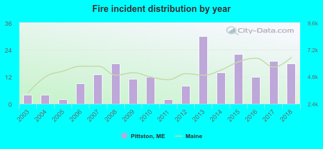 Based on the data from the years 2003 - 2018 the average number of fires per year is 12. The highest number of reported fires - 30 took place in 2013, and the least - 2 in 2005. The data has an increasing trend.
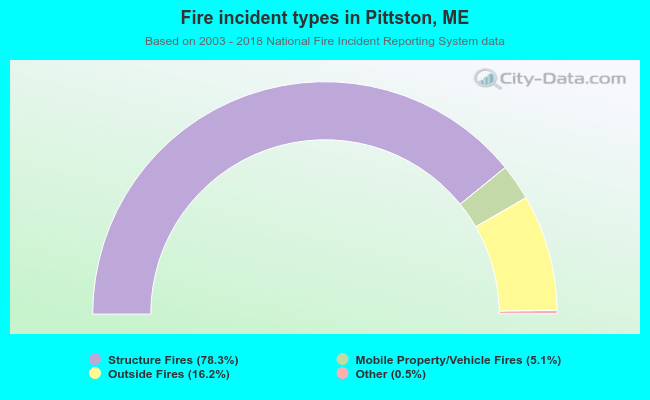 When looking into fire subcategories, the most reports belonged to: Structure Fires (78.3%), and Outside Fires (16.2%).
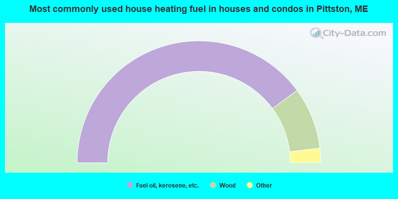
- 79.8%Fuel oil, kerosene, etc.
- 16.4%Wood
- 3.3%Electricity
- 0.5%Bottled, tank, or LP gas
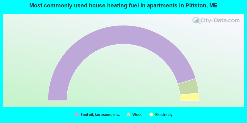
- 90.5%Fuel oil, kerosene, etc.
- 6.3%Wood
- 3.2%Electricity
Pittston compared to Maine state average:
- Unemployed percentage significantly below state average.
- Black race population percentage significantly below state average.
- Hispanic race population percentage below state average.
- Foreign-born population percentage below state average.
- Renting percentage below state average.
- Length of stay since moving in significantly above state average.
- Number of rooms per house significantly below state average.
- House age significantly below state average.
- Number of college students below state average.
- Percentage of population with a bachelor's degree or higher below state average.