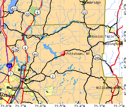
Pittstown, New York
Submit your own pictures of this town and show them to the world
- OSM Map
- General Map
- Google Map
- MSN Map
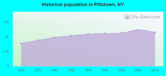
Population change since 2000: +1.6%
 |
| Males: 2,860 | |
| Females: 2,875 |
| Median resident age: | 41.7 years |
| New York median age: | 40.7 years |
Zip codes: 12094.
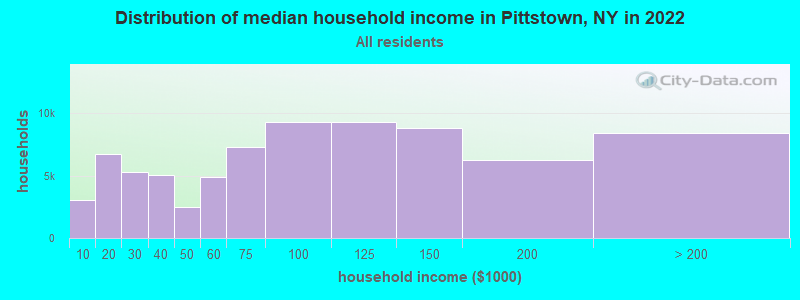
| Pittstown: | $96,790 |
| NY: | $79,557 |
Estimated per capita income in 2022: $41,139 (it was $18,578 in 2000)
Pittstown town income, earnings, and wages data
Estimated median house or condo value in 2022: $243,465 (it was $97,700 in 2000)
| Pittstown: | $243,465 |
| NY: | $400,400 |
Mean prices in 2022: all housing units: $261,820; detached houses: $276,434; townhouses or other attached units: $265,307; in 2-unit structures: $183,863; in 3-to-4-unit structures: $134,506; in 5-or-more-unit structures: $370,413; mobile homes: $66,260
Detailed information about poverty and poor residents in Pittstown, NY


- 5,54296.6%White alone
- 581.0%Hispanic
- 530.9%Two or more races
- 260.5%American Indian alone
- 260.5%Asian alone
- 250.4%Black alone
- 50.09%Other race alone
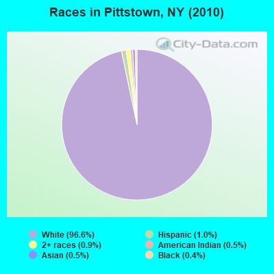
Races in Pittstown detailed stats: ancestries, foreign born residents, place of birth
 Recent articles from our blog. Our writers, many of them Ph.D. graduates or candidates, create easy-to-read articles on a wide variety of topics.

 | Is Troy Safe? (10 replies) |
| What's wrong with Troy, NY? (179 replies) |
| hossick falls questions (2 replies) |
Latest news from Pittstown, NY collected exclusively by city-data.com from local newspapers, TV, and radio stations
Ancestries: Irish (29.0%), German (17.3%), English (11.1%), French (11.0%), Italian (9.9%), United States (6.5%).
Current Local Time: EST time zone
Elevation: 578 feet
Land area: 61.7 square miles.
Population density: 93 people per square mile (very low).
81 residents are foreign born
| This town: | 1.4% |
| New York: | 20.4% |
| Pittstown town: | 2.9% ($2,828) |
| New York: | 1.9% ($2,847) |
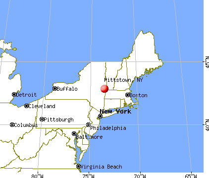
Nearest city with pop. 50,000+: Albany, NY  (20.4 miles , pop. 95,658).
Nearest city with pop. 200,000+: Boston, MA (129.0 miles , pop. 589,141).
Nearest city with pop. 1,000,000+: Bronx, NY (141.6 miles , pop. 1,332,650).
Nearest cities:
), ), Latitude: 42.88 N, Longitude: 73.51 W
Area code: 518

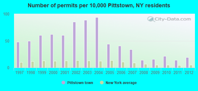
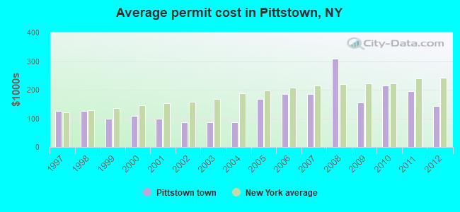
Single-family new house construction building permits:
- 2012: 11 buildings, average cost: $142,900
- 2011: 8 buildings, average cost: $193,800
- 2010: 12 buildings, average cost: $215,000
- 2009: 9 buildings, average cost: $155,600
- 2008: 8 buildings, average cost: $308,000
- 2007: 19 buildings, average cost: $185,200
- 2006: 23 buildings, average cost: $185,200
- 2005: 25 buildings, average cost: $168,400
- 2004: 53 buildings, average cost: $86,900
- 2003: 50 buildings, average cost: $86,900
- 2002: 48 buildings, average cost: $86,900
- 2001: 34 buildings, average cost: $100,000
- 2000: 35 buildings, average cost: $108,600
- 1999: 34 buildings, average cost: $100,000
- 1998: 28 buildings, average cost: $125,000
- 1997: 27 buildings, average cost: $125,000
| Here: | 3.7% |
| New York: | 4.4% |
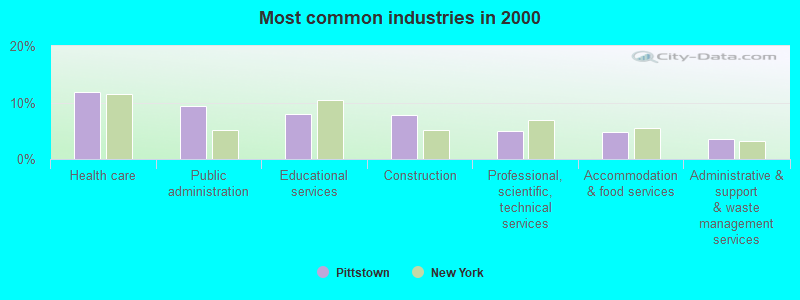
- Health care (11.8%)
- Public administration (9.4%)
- Educational services (8.0%)
- Construction (7.8%)
- Professional, scientific, technical services (5.0%)
- Accommodation & food services (4.8%)
- Administrative & support & waste management services (3.6%)
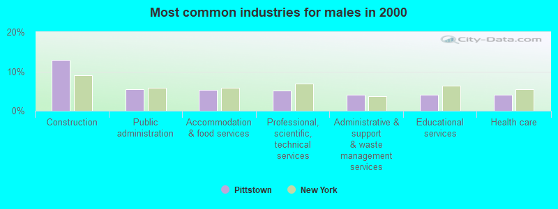
- Construction (12.9%)
- Public administration (5.5%)
- Accommodation & food services (5.3%)
- Professional, scientific, technical services (5.1%)
- Administrative & support & waste management services (4.1%)
- Educational services (4.1%)
- Health care (4.1%)
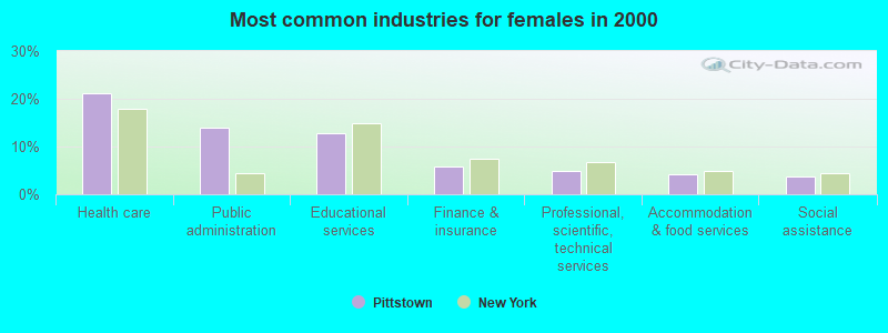
- Health care (21.2%)
- Public administration (14.1%)
- Educational services (12.8%)
- Finance & insurance (5.8%)
- Professional, scientific, technical services (4.9%)
- Accommodation & food services (4.1%)
- Social assistance (3.8%)
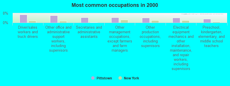
- Driver/sales workers and truck drivers (6.7%)
- Other office and administrative support workers, including supervisors (6.0%)
- Secretaries and administrative assistants (4.4%)
- Other management occupations, except farmers and farm managers (4.3%)
- Other production occupations, including supervisors (4.1%)
- Electrical equipment mechanics and other installation, maintenance, and repair workers, including supervisors (4.0%)
- Preschool, kindergarten, elementary, and middle school teachers (3.1%)
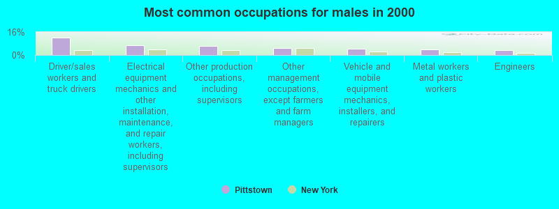
- Driver/sales workers and truck drivers (12.2%)
- Electrical equipment mechanics and other installation, maintenance, and repair workers, including supervisors (6.7%)
- Other production occupations, including supervisors (6.4%)
- Other management occupations, except farmers and farm managers (5.0%)
- Vehicle and mobile equipment mechanics, installers, and repairers (4.2%)
- Metal workers and plastic workers (4.0%)
- Engineers (3.5%)

- Other office and administrative support workers, including supervisors (10.5%)
- Secretaries and administrative assistants (9.3%)
- Preschool, kindergarten, elementary, and middle school teachers (5.0%)
- Customer service representatives (4.5%)
- Registered nurses (4.2%)
- Cashiers (4.1%)
- Other management occupations, except farmers and farm managers (3.4%)
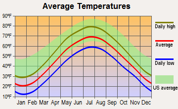
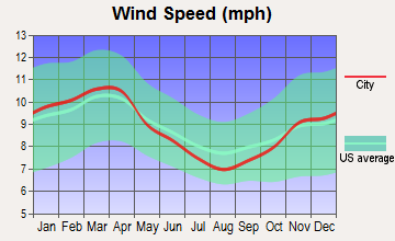
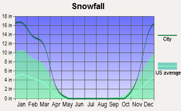
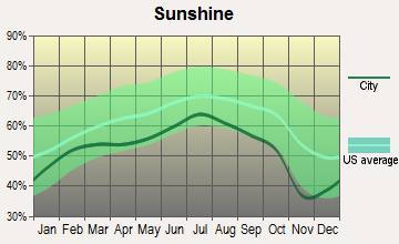
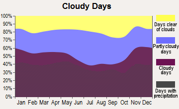
Average climate in Pittstown, New York
Based on data reported by over 4,000 weather stations
(lower is better)
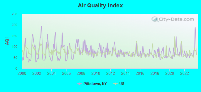
Air Quality Index (AQI) level in 2023 was 89.3. This is worse than average.
| City: | 89.3 |
| U.S.: | 72.6 |
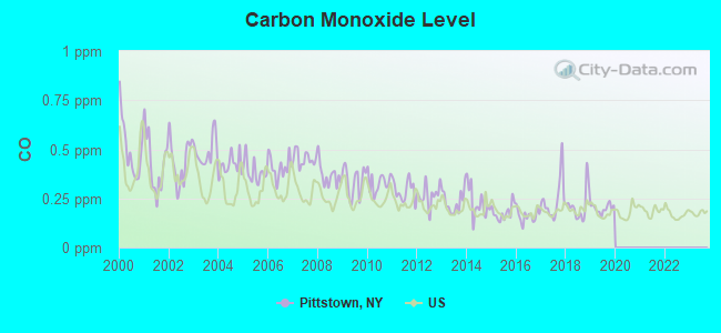
Carbon Monoxide (CO) [ppm] level in 2019 was 0.199. This is better than average. Closest monitor was 18.5 miles away from the city center.
| City: | 0.199 |
| U.S.: | 0.251 |
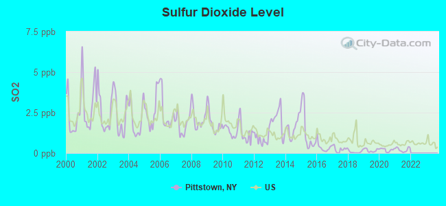
Sulfur Dioxide (SO2) [ppb] level in 2021 was 0.213. This is significantly better than average. Closest monitor was 6.9 miles away from the city center.
| City: | 0.213 |
| U.S.: | 1.515 |
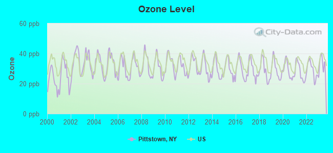
Ozone [ppb] level in 2023 was 32.4. This is about average. Closest monitor was 6.9 miles away from the city center.
| City: | 32.4 |
| U.S.: | 33.3 |
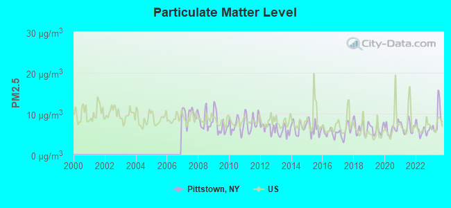
Particulate Matter (PM2.5) [µg/m3] level in 2023 was 8.60. This is about average. Closest monitor was 13.1 miles away from the city center.
| City: | 8.60 |
| U.S.: | 8.11 |
Tornado activity:
Pittstown-area historical tornado activity is above New York state average. It is 44% smaller than the overall U.S. average.
On 8/28/1973, a category F4 (max. wind speeds 207-260 mph) tornado 31.9 miles away from the Pittstown town center killed 4 people and injured 36 people and caused between $5,000,000 and $50,000,000 in damages.
On 6/24/1960, a category F3 (max. wind speeds 158-206 mph) tornado 11.7 miles away from the town center injured 9 people and caused between $5,000,000 and $50,000,000 in damages.
Earthquake activity:
Pittstown-area historical earthquake activity is significantly above New York state average. It is 68% smaller than the overall U.S. average.On 10/7/1983 at 10:18:46, a magnitude 5.3 (5.1 MB, 5.3 LG, 5.1 ML, Class: Moderate, Intensity: VI - VII) earthquake occurred 85.5 miles away from the city center
On 4/20/2002 at 10:50:47, a magnitude 5.3 (5.3 ML, Depth: 3.0 mi) earthquake occurred 113.6 miles away from Pittstown center
On 4/20/2002 at 10:50:47, a magnitude 5.2 (5.2 MB, 4.2 MS, 5.2 MW, 5.0 MW) earthquake occurred 111.9 miles away from the city center
On 1/19/1982 at 00:14:42, a magnitude 4.7 (4.5 MB, 4.7 MD, 4.5 LG, Class: Light, Intensity: IV - V) earthquake occurred 105.4 miles away from the city center
On 10/16/2012 at 23:12:25, a magnitude 4.7 (4.7 ML, Depth: 10.0 mi) earthquake occurred 152.1 miles away from the city center
On 6/17/1991 at 08:53:16, a magnitude 4.1 (4.0 MB, 4.0 LG, Depth: 3.1 mi) earthquake occurred 61.8 miles away from Pittstown center
Magnitude types: regional Lg-wave magnitude (LG), body-wave magnitude (MB), duration magnitude (MD), local magnitude (ML), surface-wave magnitude (MS), moment magnitude (MW)
Natural disasters:
The number of natural disasters in Rensselaer County (24) is greater than the US average (15).Major Disasters (Presidential) Declared: 14
Emergencies Declared: 9
Causes of natural disasters: Storms: 7, Floods: 5, Hurricanes: 5, Winter Storms: 4, Blizzards: 2, Snowstorms: 2, Tornadoes: 2, Chemical Waste: 1, Power Outage: 1, Tropical Storm: 1, Other: 2 (Note: some incidents may be assigned to more than one category).
Hospitals and medical centers near Pittstown:
- THE CENTER FOR NURSING AND REHAB AT HOOSICK FALLS (Nursing Home, about 9 miles away; HOOSICK FALLS, NY)
- DIAMOND HILL NURSING AND REHABILITATION CENTER (Nursing Home, about 10 miles away; TROY, NY)
- LEONARD HOSPITAL (Hospital, about 10 miles away; TROY, NY)
- MARY MCCLELLAN HOSPITAL (Hospital, about 12 miles away; CAMBRIDGE, NY)
- ST MARY'S HOSPITAL ( TROY ) Acute Care Hospitals (about 13 miles away; TROY, NY)
- EDDY HERITAGE HOUSE NURSING CTR (Nursing Home, about 13 miles away; TROY, NY)
- JAMES A EDDY MEMORIAL GERIATRIC CENTER (Nursing Home, about 13 miles away; TROY, NY)
Colleges/universities with over 2000 students nearest to Pittstown:
- Rensselaer Polytechnic Institute (about 14 miles; Troy, NY; Full-time enrollment: 6,940)
- The Sage Colleges (about 14 miles; Troy, NY; FT enrollment: 2,499)
- Hudson Valley Community College (about 16 miles; Troy, NY; FT enrollment: 9,346)
- Siena College (about 17 miles; Loudonville, NY; FT enrollment: 3,153)
- Williams College (about 20 miles; Williamstown, MA; FT enrollment: 2,141)
- SUNY Empire State College (about 20 miles; Saratoga Springs, NY; FT enrollment: 9,473)
- The College of Saint Rose (about 21 miles; Albany, NY; FT enrollment: 4,085)
Points of interest:
Notable locations in Pittstown: Bornt Family Farms (A), Passing Fancy Farm (B), Valley Falls Village Wastewater Treatment Facility (C), Valley Falls Free Library (D), Valley Falls Volunteer Fire Department (E), Johnsonville Fire Department (F), Pittstown Volunteer Fire Department (G), Raymertown Fire District (H). Display/hide their locations on the map
Churches in Pittstown include: Saint Georges Church (A), Pittstown United Methodist Church (B), Christ Church (C). Display/hide their locations on the map
Cemeteries: Warren Cemetery (1), Maplewood Cemetery (2). Display/hide their locations on the map
Lakes and reservoirs: Lake Lorraine (A), Newcomb Pond (B), Wing Pond (C), Echo Lake (D). Display/hide their locations on the map
Streams, rivers, and creeks: Otter Creek (A), Sunkauissia Creek (B), Nipmoose Brook (C). Display/hide their locations on the map
Birthplace of: Isaac Singer - (1811-1875), inventor of the sewing machine.
| This town: | 2.7 people |
| New York: | 2.6 people |
| This town: | 75.9% |
| Whole state: | 63.5% |
| This town: | 8.9% |
| Whole state: | 6.8% |
Likely homosexual households (counted as self-reported same-sex unmarried-partner households)
- Lesbian couples: 0.4% of all households
- Gay men: 0.3% of all households
| This town: | 6.0% |
| Whole state: | 14.6% |
| This town: | 2.4% |
| Whole state: | 7.4% |
For population 15 years and over in Pittstown:
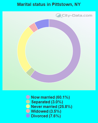
- Never married: 25.8%
- Now married: 60.1%
- Separated: 3.0%
- Widowed: 3.5%
- Divorced: 7.6%
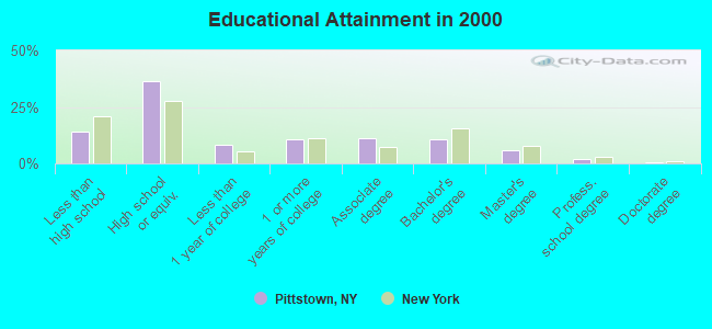
For population 25 years and over in Pittstown:
- High school or higher: 85.7%
- Bachelor's degree or higher: 18.5%
- Graduate or professional degree: 8.1%
- Unemployed: 4.7%
- Mean travel time to work (commute): 33.6 minutes
| Here: | 10.2 |
| New York average: | 14.2 |
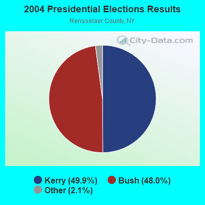
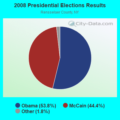
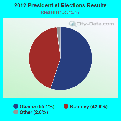
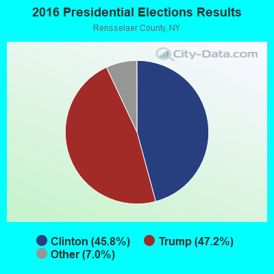
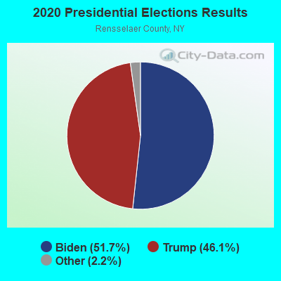
Graphs represent county-level data. Detailed 2008 Election Results
Religion statistics for Pittstown, NY (based on Rensselaer County data)
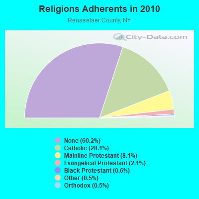
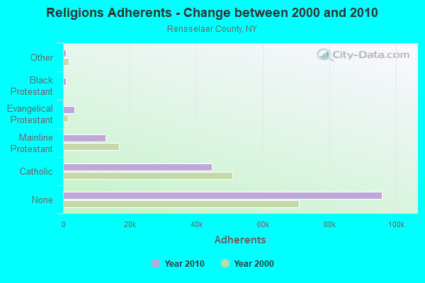
| Religion | Adherents | Congregations |
|---|---|---|
| Catholic | 44,756 | 21 |
| Mainline Protestant | 12,867 | 70 |
| Evangelical Protestant | 3,424 | 37 |
| Black Protestant | 882 | 3 |
| Other | 847 | 12 |
| Orthodox | 740 | 3 |
| None | 95,913 | - |
Food Environment Statistics:
| Rensselaer County: | 2.07 / 10,000 pop. |
| New York: | 4.13 / 10,000 pop. |
| This county: | 0.84 / 10,000 pop. |
| State: | 0.92 / 10,000 pop. |
| Rensselaer County: | 3.55 / 10,000 pop. |
| State: | 1.68 / 10,000 pop. |
| This county: | 6.07 / 10,000 pop. |
| New York: | 8.82 / 10,000 pop. |
| This county: | 7.4% |
| New York: | 8.2% |
| Here: | 26.7% |
| State: | 23.8% |
| This county: | 15.4% |
| New York: | 15.6% |
Strongest AM radio stations in Pittstown:
- WGY (810 AM; 50 kW; SCHENECTADY, NY; Owner: CLEAR CHANNEL BROADCASTING LICENSES, INC.)
- WPTR (1540 AM; 50 kW; ALBANY, NY; Owner: KIMTRON, INC.)
- WABY (1160 AM; 5 kW; MECHANICVILLE, NY; Owner: ANASTOS MEDIA GROUP, INC.)
- WNNZ (640 AM; 50 kW; WESTFIELD, MA; Owner: CLEAR CHANNEL BROADCASTING LICENSES, INC.)
- WOFX (980 AM; 5 kW; TROY, NY)
- WROW (590 AM; 5 kW; ALBANY, NY; Owner: 6 JOHNSON ROAD LICENSES, INC.)
- WTMM (1300 AM; 5 kW; RENSSELAER, NY; Owner: REGENT LICENSEE OF MANSFIELD, INC.)
- WCRN (830 AM; 50 kW; WORCESTER, MA; Owner: CARTER BROADCASTING CORPORATION)
- WDDY (1460 AM; 5 kW; ALBANY, NY)
- WTIC (1080 AM; 50 kW; HARTFORD, CT; Owner: INFINITY RADIO OPERATIONS INC.)
- WHAZ (1330 AM; 1 kW; TROY, NY; Owner: CAPITAL MEDIA CORPORATION)
- WRKO (680 AM; 50 kW; BOSTON, MA; Owner: ENTERCOM BOSTON LICENSE, LLC)
- WVNE (760 AM; daytime; 25 kW; LEICESTER, MA; Owner: BLOUNT MASSCOM, INC.)
Strongest FM radio stations in Pittstown:
- WZEC (97.5 FM; HOOSICK FALLS, NY; Owner: GREAT NORTHERN RADIO, LLC)
- WEQX (102.7 FM; MANCHESTER, VT; Owner: NORTHSHIRE COMMUNICATIONS, INC.)
- WAMC-FM (90.3 FM; ALBANY, NY; Owner: WAMC)
- WJAN (95.1 FM; SUNDERLAND, VT; Owner: 6 JOHNSON ROAD LICENSES, INC.)
- WNGN (91.9 FM; ARGYLE, NY; Owner: NORTHEAST GOSPEL BROADCASTING INC)
- WVAY (100.7 FM; WILMINGTON, VT; Owner: GREAT NORTHERN RADIO, L.L.C.)
- WQAR (101.3 FM; STILLWATER, NY; Owner: ANASTOS MEDIA GROUP, INC.)
- WAJZ (96.3 FM; VOORHEESVILLE, NY; Owner: 6 JOHNSON ROAD LICENSES, INC.)
- WABT (104.5 FM; MECHANICVILLE, NY; Owner: REGENT LICENSEE OF MANSFIELD, INC.)
- WYJB (95.5 FM; ALBANY, NY; Owner: 6 JOHNSON ROAD LICENSES, INC.)
- WJJR (98.1 FM; RUTLAND, VT; Owner: 6 JOHNSON ROAD LICENSES, INC.)
- WZRT (97.1 FM; RUTLAND, VT; Owner: CAPSTAR TX LIMITED PARTNERSHIP)
- WZMR (104.9 FM; ALTAMONT, NY; Owner: 6 JOHNSON ROAD LICENSES, INC.)
- WGNA-FM (107.7 FM; ALBANY, NY; Owner: REGENT LICENSEE OF MANSFIELD, INC.)
- WEBK (105.3 FM; KILLINGTON, VT; Owner: 6 JOHNSON ROAD LICENSES, INC.)
- WRVE (99.5 FM; SCHENECTADY, NY; Owner: CLEAR CHANNEL BROADCASTING LICENSES, INC.)
- WMHT-FM (89.1 FM; SCHENECTADY, NY; Owner: WMHT EDUCATIONAL TELECOMMUNICATIONS)
- WKBE (100.3 FM; WARRENSBURG, NY; Owner: 6 JOHNSON ROAD LICENSES, INC.)
- WPYX (106.5 FM; ALBANY, NY; Owner: CAPSTAR TX LIMITED PARTNERSHIP)
- WFFG-FM (107.1 FM; CORINTH, NY; Owner: VOX NEW YORK, L.L.C.)
TV broadcast stations around Pittstown:
- WNGN-LP (Channel 26; TROY, NY; Owner: BRIAN A. LARSON)
- WNYA-CA (Channel 39; EASTON, ETC., NY; Owner: VENTURE TECHNOLOGIES GROUP, LLC)
- WYPX (Channel 55; AMSTERDAM, NY; Owner: PAXSON ALBANY LICENSE, INC.)
- WRGB (Channel 6; SCHENECTADY, NY; Owner: FREEDOM BROADCASTING OF NEW YORK, INC)
- WNYT (Channel 13; ALBANY, NY; Owner: WNYT-TV, LLC)
- WTEN (Channel 10; ALBANY, NY; Owner: YOUNG BROADCASTING OF ALBANY, INC.)
- WMHT (Channel 17; SCHENECTADY, NY; Owner: WMHT EDUCATIONAL TELECOMMUNICATIONS)
- National Bridge Inventory (NBI) Statistics
- 21Number of bridges
- 92ft / 27.5mTotal length
- $11,755,000Total costs
- 36,758Total average daily traffic
- 2,098Total average daily truck traffic
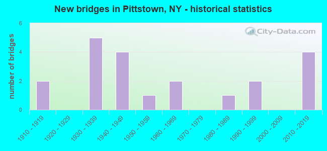
- New bridges - historical statistics
- 21910-1919
- 51930-1939
- 41940-1949
- 11950-1959
- 21960-1969
- 11980-1989
- 21990-1999
- 42010-2019
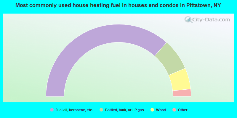
- 73.1%Fuel oil, kerosene, etc.
- 14.1%Bottled, tank, or LP gas
- 9.5%Wood
- 2.4%Electricity
- 0.5%Utility gas
- 0.5%Other fuel
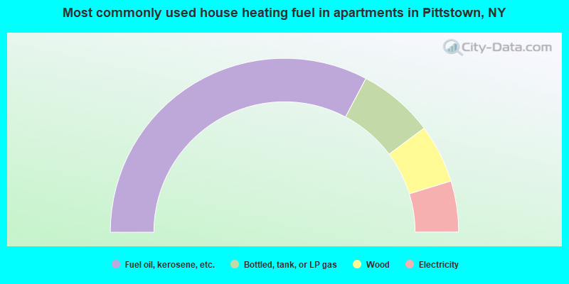
- 65.5%Fuel oil, kerosene, etc.
- 14.1%Bottled, tank, or LP gas
- 10.9%Wood
- 9.5%Electricity
Pittstown compared to New York state average:
- Median house value below state average.
- Unemployed percentage significantly below state average.
- Black race population percentage significantly below state average.
- Hispanic race population percentage significantly below state average.
- Foreign-born population percentage significantly below state average.
- Renting percentage significantly below state average.
- Length of stay since moving in significantly above state average.
- Number of rooms per house significantly below state average.
- House age significantly below state average.
- Percentage of population with a bachelor's degree or higher below state average.
Pittstown on our top lists:
- #1 on the list of "Top 101 cities with largest percentage of males in industries: retail florists (population 5,000+)"
- #5 on the list of "Top 101 cities with largest percentage of males in occupations: social scientists and related workers (population 5,000+)"
- #11 on the list of "Top 101 cities with largest percentage of males in occupations: driver/sales workers and truck drivers (population 5,000+)"
- #22 on the list of "Top 101 cities with largest percentage of males in industries: vending machine operators (population 5,000+)"
- #27 on the list of "Top 101 cities with largest percentage of females in industries: recyclable material merchant wholesalers (population 5,000+)"
- #31 on the list of "Top 101 cities with largest percentage of females in occupations: other office and administrative support workers including supervisors (population 5,000+)"
- #32 on the list of "Top 101 cities with largest percentage of males in industries: publishing, and motion picture and sound recording industries (population 5,000+)"
- #35 on the list of "Top 101 cities with largest percentage of females in occupations: communications equipment operators (population 5,000+)"
- #42 on the list of "Top 101 cities with largest percentage of females in occupations: woodworkers (population 5,000+)"
- #43 on the list of "Top 101 cities with largest percentage of males in industries: miscellaneous durable goods merchant wholesalers (population 5,000+)"
- #45 on the list of "Top 101 cities with largest percentage of females in occupations: supervisors of transportation and material moving workers (population 5,000+)"
- #51 on the list of "Top 101 cities with largest percentage of females in industries: other direct selling establishments (population 5,000+)"
- #60 on the list of "Top 101 cities with largest percentage of males in industries: water transportation (population 5,000+)"
- #70 on the list of "Top 101 cities with largest percentage of females in industries: pharmacies and drug stores (population 5,000+)"
- #74 on the list of "Top 101 cities with largest percentage of females in industries: nonmetallic mineral products (population 5,000+)"
- #79 on the list of "Top 101 cities with largest percentage of males in industries: other direct selling establishments (population 5,000+)"
- #76 on the list of "Top 101 counties with the lowest Sulfur Oxides Annual air pollution readings in 2012 (µg/m3)"
- #95 on the list of "Top 101 counties with the lowest percentage of residents relocating from foreign countries between 2010 and 2011"

|
Total of 1 patent application in 2008-2024.