Pleasant Dale, Nebraska
Submit your own pictures of this village and show them to the world
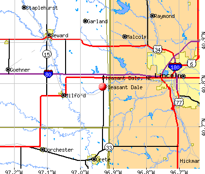
- OSM Map
- General Map
- Google Map
- MSN Map
Population change since 2000: -13.5%
 |
| Males: 116 | |
| Females: 96 |
| Median resident age: | 35.4 years |
| Nebraska median age: | 37.4 years |
Zip codes: 68423.
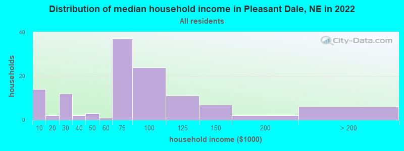
| Pleasant Dale: | $60,562 |
| NE: | $69,597 |
Estimated per capita income in 2022: $35,193 (it was $20,190 in 2000)
Pleasant Dale village income, earnings, and wages data
Estimated median house or condo value in 2022: $191,594 (it was $84,200 in 2000)
| Pleasant Dale: | $191,594 |
| NE: | $232,400 |
Mean prices in 2022: all housing units: $203,564; detached houses: $203,111
Median gross rent in 2022: $771.
(10.2% for White Non-Hispanic residents, 100.0% for American Indian residents)
Compare current foreclosures near Pleasant Dale, NE:
| Photo | Address | Area | Beds / Baths | Price | Details |
|---|---|---|---|---|---|

|
#1
154th
Pleasant Dale, NE 68423
|
2,220 sq. feet
|
1 baths 4 beds |
show details | |

|
#2
S 18th St
Lincoln, NE 68508
|
1,072 sq. feet
|
2 baths 3 beds |
show details | |

|
#3
Garden Valley Rd
Lincoln, NE 68521
|
2,019 sq. feet
|
2 baths 3 beds |
show details | |

|
#4
La Brea Ave
Lincoln, NE 68504
|
1,032 sq. feet
|
2 baths 3 beds |
show details | |

|
#5
N 10th St
Lincoln, NE 68521
|
1,395 sq. feet
|
1 baths 2 beds |
show details | |

|
#6
Pawnee St
Lincoln, NE 68506
|
1,036 sq. feet
|
2 baths 3 beds |
show details | |

|
#7
W Washington St
Lincoln, NE 68522
|
- sq. feet
|
2 baths 2 beds |
show details | |

|
#8
S 26th St
Lincoln, NE 68510
|
1,404 sq. feet
|
1 baths 2 beds |
show details | |

|
#9
S 56th St
Lincoln, NE 68516
|
2,082 sq. feet
|
3 baths 3 beds |
show details | |

|
#10
Elk Ridge Rd
Lincoln, NE 68516
|
3,718 sq. feet
|
2 baths 2 beds |
show details |
| Photo | Address | Area | Beds / Baths | Price | Details |
|---|---|---|---|---|---|

|
#11
Belridge Dr
Lincoln, NE 68521
|
1,486 sq. feet
|
1 baths 3 beds |
show details | |

|
#12
Ryons St
Lincoln, NE 68502
|
1,200 sq. feet
|
1 baths 3 beds |
show details | |

|
#13
Martin St
Lincoln, NE 68504
|
1,290 sq. feet
|
1 baths 2 beds |
show details | |

|
#14
S 54th St
Lincoln, NE 68516
|
780 sq. feet
|
1 baths 1 beds |
show details | |

|
#15
Southwood Pl
Lincoln, NE 68512
|
1,152 sq. feet
|
1 baths 3 beds |
show details | |

|
#16
Orchard St
Lincoln, NE 68504
|
1,440 sq. feet
|
1 baths 1 beds |
show details | |

|
#17
Y St
Lincoln, NE 68503
|
1,497 sq. feet
|
1 baths 4 beds |
show details | |

|
#18
Meredeth St
Lincoln, NE 68506
|
2,148 sq. feet
|
3 baths 4 beds |
show details | |

|
#19
S 25th St
Lincoln, NE 68512
|
2,492 sq. feet
|
3 baths 3 beds |
show details | |

|
#20
Prescott Ave
Lincoln, NE 68506
|
1,656 sq. feet
|
2 baths 2 beds |
show details |
| Photo | Address | Area | Beds / Baths | Price | Details |
|---|---|---|---|---|---|

|
#21
Garden Valley Rd
Lincoln, NE 68521
|
1,620 sq. feet
|
2 baths 3 beds |
show details | |

|
#22
Orchard St
Lincoln, NE 68503
|
720 sq. feet
|
1 baths 2 beds |
show details | |

|
#23
Southwood Pl
Lincoln, NE 68512
|
1,486 sq. feet
|
1 baths 3 beds |
show details | |

|
#24
Sheridan Blvd
Lincoln, NE 68502
|
2,406 sq. feet
|
2 baths 3 beds |
show details | |

|
#25
N 12th St
Lincoln, NE 68521
|
1,426 sq. feet
|
2 baths 3 beds |
show details | |

|
#26
N 59th St
Lincoln, NE 68505
|
825 sq. feet
|
1 baths 2 beds |
show details | |

|
#27
Sumner St
Lincoln, NE 68502
|
2,178 sq. feet
|
2 baths 2 beds |
show details | |

|
#28
Saint Paul Ave
Lincoln, NE 68507
|
1,934 sq. feet
|
2 baths 2 beds |
show details | |

|
#29
S 45th St
Lincoln, NE 68516
|
2,052 sq. feet
|
2 baths 4 beds |
show details | |

|
#30
Earl Dr
Lincoln, NE 68505
|
1,580 sq. feet
|
1 baths 2 beds |
show details |
| Photo | Address | Area | Beds / Baths | Price | Details |
|---|---|---|---|---|---|

|
#31
N 11th St
Lincoln, NE 68521
|
1,167 sq. feet
|
2 baths 3 beds |
show details | |

|
#32
Dunn Ave
Lincoln, NE 68502
|
768 sq. feet
|
1 baths 2 beds |
show details | |

|
#33
Sheridan Blvd
Lincoln, NE 68502
|
2,406 sq. feet
|
2 baths 3 beds |
show details | |

|
#34
Grassridge Rd
Lincoln, NE 68512
|
1,368 sq. feet
|
1 baths 3 beds |
show details | |

|
#35
N 53rd St
Lincoln, NE 68504
|
1,794 sq. feet
|
2 baths 3 beds |
show details | |

|
#36
Lee Cir
Lincoln, NE 68506
|
1,125 sq. feet
|
1 baths 2 beds |
show details | |

|
#37
S 23rd St
Lincoln, NE 68502
|
1,518 sq. feet
|
1 baths 4 beds |
show details | |

|
#38
Francis St
Lincoln, NE 68504
|
1,932 sq. feet
|
2 baths 4 beds |
show details | |

|
#39
Woods Blvd
Lincoln, NE 68502
|
1,552 sq. feet
|
1 baths 3 beds |
show details | |

|
#40
Goldenrod Cir
Lincoln, NE 68512
|
1,736 sq. feet
|
2 baths 3 beds |
show details |
| Photo | Address | Area | Beds / Baths | Price | Details |
|---|---|---|---|---|---|

|
#41
Prince Rd Apt 4
Lincoln, NE 68516
|
840 sq. feet
|
1 baths 2 beds |
show details | |

|
#42
F St
Lincoln, NE 68510
|
1,616 sq. feet
|
2 baths 2 beds |
show details | |

|
#43
S 52nd St
Lincoln, NE 68510
|
1,516 sq. feet
|
2 baths 2 beds |
show details | |

|
#44
S 50th St
Lincoln, NE 68510
|
1,857 sq. feet
|
2 baths 3 beds |
show details | |

|
#45
Washington St
Lincoln, NE 68506
|
1,808 sq. feet
|
1 baths 2 beds |
show details | |

|
#46
Brummond Dr
Lincoln, NE 68516
|
2,253 sq. feet
|
3 baths 2 beds |
show details | |

|
#47
Garfield St
Lincoln, NE 68506
|
818 sq. feet
|
1 baths 2 beds |
show details | |

|
#48
Frederick Cir
Lincoln, NE 68504
|
1,934 sq. feet
|
2 baths 3 beds |
show details | |

|
#49
X St
Lincoln, NE 68503
|
1,698 sq. feet
|
2 baths 2 beds |
show details | |

|
Check over 1 million property listings on Foreclosure.com!
|
browse all offers | |||


- 25397.3%White alone
- 10.4%Two or more races
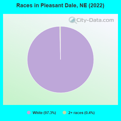
Races in Pleasant Dale detailed stats: ancestries, foreign born residents, place of birth
According to our research of Nebraska and other state lists, there were 2 registered sex offenders living in Pleasant Dale, Nebraska as of April 25, 2024.
The ratio of all residents to sex offenders in Pleasant Dale is 109 to 1.
 Recent articles from our blog. Our writers, many of them Ph.D. graduates or candidates, create easy-to-read articles on a wide variety of topics.

 | In need of your assistance | California to Nowhere (9 replies) |
| Looking for a suggestion on small towns around Lincoln,Ne 20 miles or so away? (4 replies) |
Latest news from Pleasant Dale, NE collected exclusively by city-data.com from local newspapers, TV, and radio stations
Ancestries: German (44.9%), Czech (22.4%), American (15.0%), English (4.7%), Danish (1.9%), Dutch (1.9%).
Current Local Time: CST time zone
Incorporated in 1882
Elevation: 1321 feet
Land area: 0.09 square miles.
Population density: 2,449 people per square mile (low).
2 residents are foreign born
| This village: | 0.8% |
| Nebraska: | 4.4% |
Median real estate property taxes paid for housing units with mortgages in 2022: $3,291 (1.6%)
Median real estate property taxes paid for housing units with no mortgage in 2022: $1,956 (1.2%)
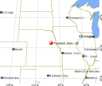
Nearest city with pop. 50,000+: Lincoln, NE  (13.5 miles , pop. 225,581).
Nearest city with pop. 1,000,000+: Chicago, IL (485.9 miles , pop. 2,896,016).
Nearest cities:
), ), ), ), Latitude: 40.79 N, Longitude: 96.93 W
Area code: 402
Single-family new house construction building permits:
- 2016: 1 building, cost: $260,000
- 2015: 2 buildings, average cost: $220,500
- 2011: 2 buildings, average cost: $254,000
- 2010: 1 building, cost: $137,000
- 2009: 1 building, cost: $145,000
- 2008: 1 building, cost: $100,000
- 2007: 4 buildings, average cost: $53,800
- 2001: 1 building, cost: $90,000
- 2000: 1 building, cost: $90,000
- 1997: 2 buildings, average cost: $77,500
| Here: | 2.1% |
| Nebraska: | 2.2% |
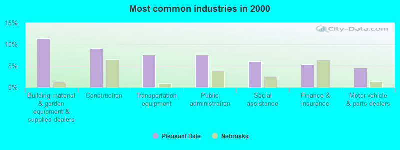
- Building material & garden equipment & supplies dealers (11.4%)
- Construction (9.1%)
- Transportation equipment (7.6%)
- Public administration (7.6%)
- Social assistance (6.1%)
- Finance & insurance (5.3%)
- Motor vehicle & parts dealers (4.5%)
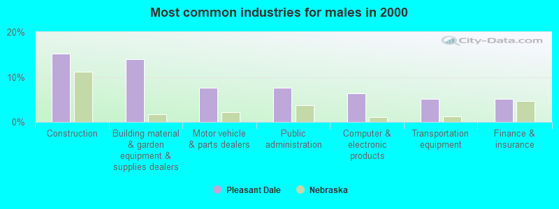
- Construction (15.2%)
- Building material & garden equipment & supplies dealers (13.9%)
- Motor vehicle & parts dealers (7.6%)
- Public administration (7.6%)
- Computer & electronic products (6.3%)
- Transportation equipment (5.1%)
- Finance & insurance (5.1%)

- Transportation equipment (11.3%)
- Professional, scientific, technical services (11.3%)
- Social assistance (9.4%)
- Building material & garden equipment & supplies dealers (7.5%)
- Public administration (7.5%)
- Health care (7.5%)
- Metal & metal products (5.7%)

- Other production occupations, including supervisors (8.3%)
- Secretaries and administrative assistants (6.8%)
- Information and record clerks, except customer service representatives (5.3%)
- Other sales and related occupations, including supervisors (5.3%)
- Retail sales workers, except cashiers (5.3%)
- Computer specialists (4.5%)
- Driver/sales workers and truck drivers (3.8%)

- Other production occupations, including supervisors (11.4%)
- Retail sales workers, except cashiers (7.6%)
- Computer specialists (6.3%)
- Other sales and related occupations, including supervisors (6.3%)
- Metal workers and plastic workers (6.3%)
- Driver/sales workers and truck drivers (6.3%)
- Electrical equipment mechanics and other installation, maintenance, and repair workers, including supervisors (5.1%)

- Secretaries and administrative assistants (17.0%)
- Information and record clerks, except customer service representatives (13.2%)
- Material recording, scheduling, dispatching, and distributing workers (5.7%)
- Nursing, psychiatric, and home health aides (3.8%)
- Other teachers, instructors, education, training, and library occupations (3.8%)
- Building and grounds cleaning and maintenance occupations (3.8%)
- Health technologists and technicians (3.8%)
Average climate in Pleasant Dale, Nebraska
Based on data reported by over 4,000 weather stations


(lower is better)
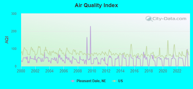
Air Quality Index (AQI) level in 2022 was 43.2. This is significantly better than average.
| City: | 43.2 |
| U.S.: | 72.6 |
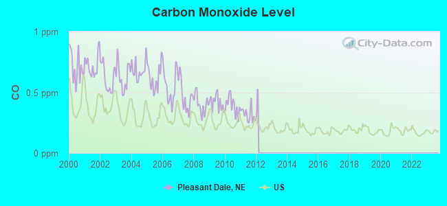
Carbon Monoxide (CO) [ppm] level in 2011 was 0.319. This is worse than average. Closest monitor was 12.7 miles away from the city center.
| City: | 0.319 |
| U.S.: | 0.251 |
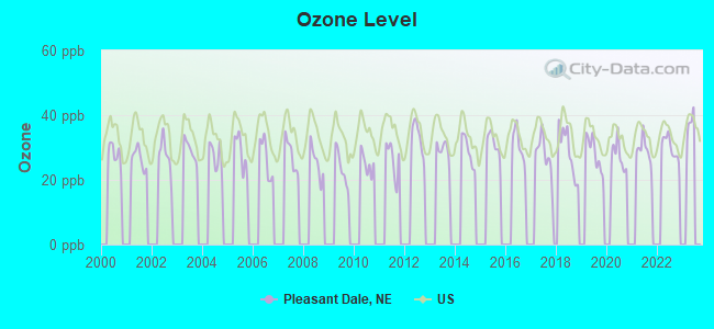
Ozone [ppb] level in 2022 was 30.1. This is about average. Closest monitor was 12.9 miles away from the city center.
| City: | 30.1 |
| U.S.: | 33.3 |
Tornado activity:
Pleasant Dale-area historical tornado activity is slightly above Nebraska state average. It is 106% greater than the overall U.S. average.
On 6/13/2001, a category F4 (max. wind speeds 207-260 mph) tornado 8.7 miles away from the Pleasant Dale village center injured 2 people and caused $1 million in damages.
On 5/5/1964, a category F5 (max. wind speeds 261-318 mph) tornado 42.4 miles away from the village center killed 4 people and injured 50 people and caused between $500,000 and $5,000,000 in damages.
Earthquake activity:
Pleasant Dale-area historical earthquake activity is significantly above Nebraska state average. It is 379% greater than the overall U.S. average.On 9/3/2016 at 12:02:44, a magnitude 5.8 (5.8 MW, Depth: 3.5 mi, Class: Moderate, Intensity: VI - VII) earthquake occurred 302.0 miles away from Pleasant Dale center
On 11/6/2011 at 03:53:10, a magnitude 5.7 (5.7 MW, Depth: 3.2 mi) earthquake occurred 363.9 miles away from the city center
On 6/22/2019 at 08:50:24, a magnitude 4.6 (4.6 MW, Depth: 1.9 mi, Class: Light, Intensity: IV - V) earthquake occurred 171.2 miles away from the city center
On 11/12/2014 at 21:40:00, a magnitude 4.9 (4.9 MW, Depth: 2.5 mi) earthquake occurred 246.3 miles away from Pleasant Dale center
On 1/19/2020 at 19:08:42, a magnitude 4.5 (4.5 MW, Depth: 3.1 mi) earthquake occurred 199.3 miles away from the city center
On 2/13/2016 at 17:07:06, a magnitude 5.1 (5.1 MW, Depth: 5.2 mi) earthquake occurred 312.6 miles away from the city center
Magnitude types: moment magnitude (MW)
Natural disasters:
The number of natural disasters in Seward County (15) is near the US average (15).Major Disasters (Presidential) Declared: 12
Emergencies Declared: 1
Causes of natural disasters: Floods: 10, Storms: 9, Tornadoes: 4, Winds: 4, Winter Storms: 2, Hurricane: 1, Ice Storm: 1, Snow: 1, Snowstorm: 1, Other: 1 (Note: some incidents may be assigned to more than one category).
Hospitals and medical centers near Pleasant Dale:
- CRESTVIEW CARE CENTER (Nursing Home, about 7 miles away; MILFORD, NE)
- MEMORIAL HEALTH CARE SYSTEMS Critical Access Hospitals (about 12 miles away; SEWARD, NE)
- TABITHA SUMNER HOUSE (Nursing Home, about 12 miles away; LINCOLN, NE)
- LANCASTER MANOR (Nursing Home, about 12 miles away; LINCOLN, NE)
- BETHESDA CARE CENTER (Nursing Home, about 13 miles away; SEWARD, NE)
- CRETE MANOR (Nursing Home, about 13 miles away; CRETE, NE)
- BRYANLGH MEDICAL CENTER WEST LTC (Nursing Home, about 13 miles away; LINCOLN, NE)
Amtrak station near Pleasant Dale:
Colleges/universities with over 2000 students nearest to Pleasant Dale:
- University of Nebraska-Lincoln (about 13 miles; Lincoln, NE; Full-time enrollment: 20,817)
- Nebraska Wesleyan University (about 16 miles; Lincoln, NE; FT enrollment: 2,072)
- Southeast Community College Area (about 17 miles; Lincoln, NE; FT enrollment: 8,838)
- University of Nebraska at Omaha (about 58 miles; Omaha, NE; FT enrollment: 12,073)
- Bellevue University (about 59 miles; Bellevue, NE; FT enrollment: 7,139)
- University of Nebraska Medical Center (about 60 miles; Omaha, NE; FT enrollment: 2,815)
- Creighton University (about 61 miles; Omaha, NE; FT enrollment: 5,370)
Points of interest:
Notable location: Pleasant Dale Volunteer Fire Department (A). Display/hide its location on the map
Church in Pleasant Dale: Bethlehem Lutheran Church (A). Display/hide its location on the map
Drinking water stations with addresses in Pleasant Dale and their reported violations in the past:
PLEASANT DALE, VILLAGE OF (Population served: 205, Groundwater):Past health violations:Past monitoring violations:
- MCL, Monthly (TCR) - In APR-2010, Contaminant: Coliform. Follow-up actions: St Public Notif requested (MAY-07-2010), St Violation/Reminder Notice (MAY-07-2010), St Public Notif received (MAY-24-2010)
- One routine major monitoring violation
| This village: | 2.2 people |
| Nebraska: | 2.5 people |
| This village: | 68.5% |
| Whole state: | 64.8% |
| This village: | 1.1% |
| Whole state: | 6.0% |
No gay or lesbian households reported
For population 15 years and over in Pleasant Dale:
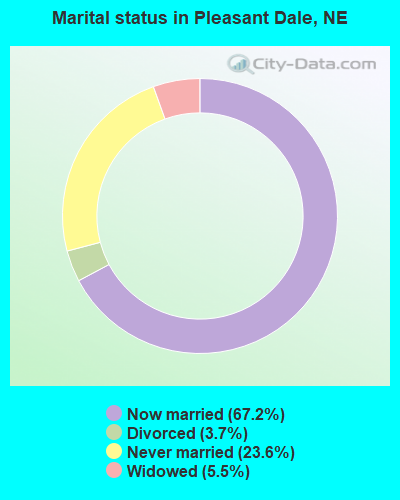
- Never married: 23.6%
- Now married: 67.2%
- Separated: 0.0%
- Widowed: 5.5%
- Divorced: 3.7%
For population 25 years and over in Pleasant Dale:
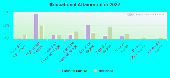
- High school or higher: 97.9%
- Bachelor's degree or higher: 11.0%
- Graduate or professional degree: 4.7%
- Unemployed: 1.5%
- Mean travel time to work (commute): 21.8 minutes
| Here: | 7.0 |
| Nebraska average: | 11.2 |
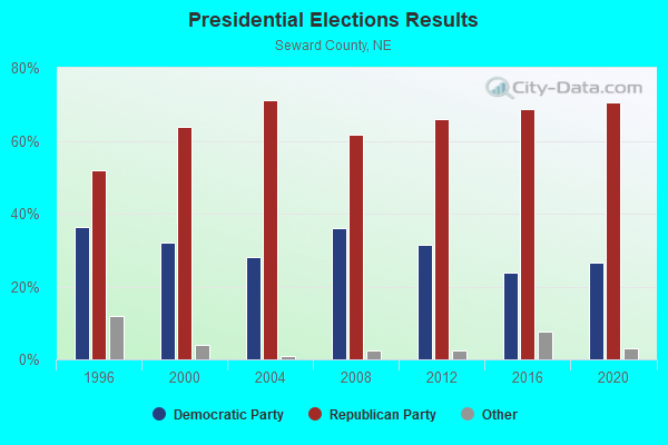
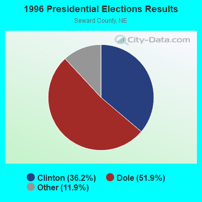
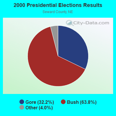

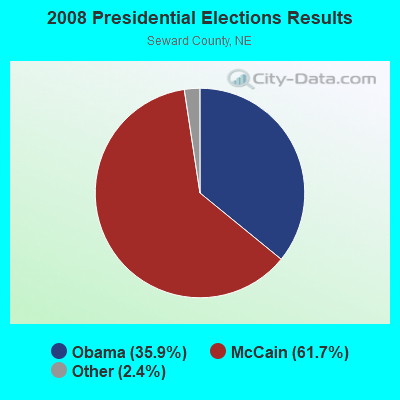


Graphs represent county-level data. Detailed 2008 Election Results
Religion statistics for Pleasant Dale, NE (based on Seward County data)
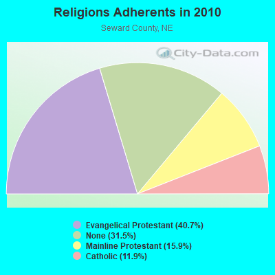
| Religion | Adherents | Congregations |
|---|---|---|
| Evangelical Protestant | 6,815 | 24 |
| Mainline Protestant | 2,664 | 12 |
| Catholic | 1,993 | 4 |
| Other | 3 | 1 |
| None | 5,275 | - |
Food Environment Statistics:
| This county: | 2.42 / 10,000 pop. |
| Nebraska: | 2.60 / 10,000 pop. |
| Seward County: | 0.61 / 10,000 pop. |
| State: | 0.44 / 10,000 pop. |
| Seward County: | 4.84 / 10,000 pop. |
| State: | 4.83 / 10,000 pop. |
| This county: | 6.05 / 10,000 pop. |
| Nebraska: | 7.76 / 10,000 pop. |
| This county: | 7.9% |
| Nebraska: | 7.9% |
| Seward County: | 27.1% |
| State: | 28.0% |
| Here: | 13.1% |
| Nebraska: | 12.9% |
Health and Nutrition:
| This city: | 49.0% |
| Nebraska: | 48.9% |
| Pleasant Dale: | 48.9% |
| Nebraska: | 45.5% |
| Pleasant Dale: | 26.9 |
| Nebraska: | 28.6 |
| Pleasant Dale: | 55.2% |
| State: | 21.4% |
| This city: | 5.7% |
| Nebraska: | 10.5% |
| Here: | 6.5 |
| Nebraska: | 6.8 |
| Pleasant Dale: | 41.1% |
| Nebraska: | 55.6% |
| This city: | 95.0% |
| State: | 78.2% |
More about Health and Nutrition of Pleasant Dale, NE Residents
| Local government employment and payroll (March 2022) | |||||
| Function | Full-time employees | Monthly full-time payroll | Average yearly full-time wage | Part-time employees | Monthly part-time payroll |
|---|---|---|---|---|---|
| Financial Administration | 0 | $0 | 2 | $2,054 | |
| Other Government Administration | 0 | $0 | 5 | $518 | |
| Totals for Government | 0 | $0 | 7 | $2,571 | |
Pleasant Dale government finances - Expenditure in 2017 (per resident):
- Construction - Police Protection: $101,000 ($476.42)
Local Fire Protection: $64,000 ($301.89)
Regular Highways: $25,000 ($117.92)
Water Utilities: $20,000 ($94.34)
Parks and Recreation: $9,000 ($42.45)
Central Staff Services: $8,000 ($37.74)
Financial Administration: $6,000 ($28.30)
Libraries: $3,000 ($14.15)
General Public Buildings: $1,000 ($4.72)
- Current Operations - Central Staff Services: $37,000 ($174.53)
Financial Administration: $29,000 ($136.79)
Water Utilities: $15,000 ($70.75)
General Public Buildings: $6,000 ($28.30)
Regular Highways: $5,000 ($23.58)
Parks and Recreation: $1,000 ($4.72)
Police Protection: $1,000 ($4.72)
- Total Salaries and Wages: $44,000 ($207.55)
Pleasant Dale government finances - Revenue in 2017 (per resident):
- Charges - Other: $20,000 ($94.34)
- Local Intergovernmental - General Local Government Support: $2,000 ($9.43)
- Miscellaneous - Interest Earnings: $8,000 ($37.74)
General Revenue - Other: $8,000 ($37.74)
- Revenue - Water Utilities: $22,000 ($103.77)
- State Intergovernmental - Highways: $24,000 ($113.21)
Other: $3,000 ($14.15)
General Local Government Support: $2,000 ($9.43)
- Tax - Property: $47,000 ($221.70)
Pleasant Dale government finances - Debt in 2017 (per resident):
- Long Term Debt - Retired Unspecified Public Purpose: $7,000 ($33.02)
Outstanding Unspecified Public Purpose: $7,000 ($33.02)
Issue, Unspecified Public Purpose: $7,000 ($33.02)
Beginning Outstanding - Unspecified Public Purpose: $7,000 ($33.02)
Pleasant Dale government finances - Cash and Securities in 2017 (per resident):
- Other Funds - Cash and Securities: $391,000 ($1844.34)
Strongest AM radio stations in Pleasant Dale:
- KFAB (1110 AM; 50 kW; OMAHA, NE; Owner: CAPSTAR TX LIMITED PARTNERSHIP)
- KOIL (1020 AM; 50 kW; PLATTSMOUTH, NE; Owner: WAITT RADIO, INC.)
- KKAR (1290 AM; 50 kW; OMAHA, NE; Owner: WAITT RADIO, INC.)
- KYDZ (1180 AM; 25 kW; BELLEVUE, NE; Owner: WAITT RADIO, INC.)
- KFOR (1240 AM; 1 kW; LINCOLN, NE; Owner: THREE EAGLES OF LINCOLN, INC.)
- KMMJ (750 AM; 10 kW; GRAND ISLAND, NE; Owner: JRK BROADCASTING, L.L.C.)
- KLIN (1400 AM; 1 kW; LINCOLN, NE; Owner: MONTEREY LICENSES, LLC)
- KRVN (880 AM; 50 kW; LEXINGTON, NE; Owner: NEBRASKA RURAL RADIO ASSOCIATION)
- WHB (810 AM; 50 kW; KANSAS CITY, MO; Owner: UNION BROADCASTING, INC.)
- KOMJ (590 AM; 5 kW; OMAHA, NE; Owner: JOURNAL BROADCAST CORPORATION)
- KLMS (1480 AM; 1 kW; LINCOLN, NE; Owner: THREE EAGLES OF LINCOLN, INC.)
- KOZN (1620 AM; 10 kW; BELLEVUE, NE; Owner: WAITT RADIO, INC.)
- KLNG (1560 AM; daytime; 10 kW; COUNCIL BLUFFS, IA)
Strongest FM radio stations in Pleasant Dale:
- KIBZ (106.3 FM; LINCOLN, NE; Owner: CAPSTAR TX LIMITED PARTNERSHIP)
- KTGL (92.9 FM; BEATRICE, NE; Owner: CAPSTAR TX LIMITED PARTNERSHIP)
- KUCV (91.1 FM; LINCOLN, NE; Owner: NEBRASKA EDUCATIONAL TELECOMMUNICATIONS COMM.)
- KFRX (102.7 FM; LINCOLN, NE; Owner: THREE EAGLES OF LINCOLN, INC.)
- KBBK (107.3 FM; LINCOLN, NE; Owner: MONTEREY LICENSES, LLC)
- KSLI-FM (104.1 FM; CRETE, NE; Owner: CAPSTAR TX LIMITED PARTNERSHIP)
- KEFM (96.1 FM; OMAHA, NE; Owner: WEBSTER COMMUNICATIONS CO.)
- KKUL (105.3 FM; LINCOLN, NE; Owner: MONTEREY LICENSES, LLC)
- K220GT (91.9 FM; LINCOLN, NE; Owner: EDUCATIONAL MEDIA FOUNDATION)
- KTMX (104.9 FM; YORK, NE; Owner: PRAIRIE STATES BROADCASTING, INC.)
- KZKX (96.9 FM; SEWARD, NE; Owner: CAPSTAR TX LIMITED PARTNERSHIP)
- KRKR (95.1 FM; LINCOLN, NE; Owner: THREE EAGLES OF LINCOLN, INC.)
- KLTQ (101.9 FM; LINCOLN, NE; Owner: WAITT RADIO, INC.)
- KGBI-FM (100.7 FM; OMAHA, NE; Owner: GRACE UNIVERSITY)
- KFLV (89.9 FM; WILBER, NE; Owner: EDUCATIONAL MEDIA FOUNDATION)
- KBBX-FM (97.7 FM; NEBRASKA CITY, NE; Owner: JOURNAL BROADCAST CORPORATION)
- KLCV (88.5 FM; LINCOLN, NE; Owner: COMMUNITY BROADCASTING, INC.)
- KRNU (90.3 FM; LINCOLN, NE; Owner: UNIVERSITY OF NEBRASKA)
- KZUM (89.3 FM; LINCOLN, NE; Owner: SUNRISE COMMUNICATIONS, INC.)
TV broadcast stations around Pleasant Dale:
- KLKN (Channel 8; LINCOLN, NE; Owner: CITADEL COMMUNICATIONS, L.L.C.)
- KOLN (Channel 10; LINCOLN, NE; Owner: KOLN/KGIN LICENSE, INC.)
- KUON-TV (Channel 12; LINCOLN, NE; Owner: THE UNIVERSITY OF NEBRASKA)
- K21ES (Channel 21; COLUMBUS, ETC, NE; Owner: DAVID C. BRODAHL)
- KPTM (Channel 42; OMAHA, NE; Owner: PAPPAS TELECASTING OF THE MIDLANDS)
- KXVO (Channel 15; OMAHA, NE; Owner: MITTS TELECASTING COMPANY)
- K18CD (Channel 18; LINCOLN, NE; Owner: COLINS BROADCASTING COMPANY)
- K27GX (Channel 27; LINCOLN, NE; Owner: THREE ANGELS BROADCASTING NETWORK)
- KWAZ-LP (Channel 22; LINCOLN, NE; Owner: COLINS BROADCASTING COMPANY)
- K54EU (Channel 54; COLUMBUS-FREMONT, NE; Owner: GLENDA R. HARDERS)
- K67CV (Channel 67; LINCOLN, NE; Owner: CHANNEL AMERICA LPTV LIC. SUBSIDIARY)
- KYNE-TV (Channel 26; OMAHA, NE; Owner: NEBRASKA EDUCATIONAL TELECOMMUNICATIONS COMM.)
- K58GD (Channel 58; LINCOLN, NE; Owner: TRINITY BROADCASTING NETWORK)
Pleasant Dale fatal accident list:
- National Bridge Inventory (NBI) Statistics
- 33Number of bridges
- 226ft / 68.8mTotal length
- 259,346Total average daily traffic
- 61,869Total average daily truck traffic
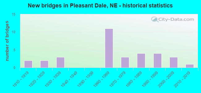
- New bridges - historical statistics
- 21910-1919
- 21920-1929
- 31930-1939
- 111960-1969
- 31970-1979
- 41980-1989
- 41990-1999
- 32000-2009
- 12010-2019
FCC Registered Cell Phone Towers:
1 (See the full list of FCC Registered Cell Phone Towers in Pleasant Dale)FCC Registered Antenna Towers:
15 (See the full list of FCC Registered Antenna Towers)FCC Registered Broadcast Land Mobile Towers:
2- Nw Quarter Sec 3 Twp 9 N Range 4 E (Lat: 40.785833 Lon: -96.963361), Type: Pole, Structure height: 9 m, Overall height: 11 m, Call Sign: WPLR232,
Assigned Frequencies: 456.162 MHz, Grant Date: 09/25/2012, Expiration Date: 12/09/2022, Cancellation Date: 02/11/2023, Certifier: Joel Navis, Registrant: Ita Inc, 1270 Fairfield Rd Ste 33, Gettysburg, PA 17325, Fax: (717) 334-9602
- Ne Of Section 2, Township 9, North Range 4 East (Lat: 40.785833 Lon: -96.963361), Type: Pole, Structure height: 9 m, Call Sign: WQFY728, Licensee ID: L00049116,
Assigned Frequencies: 456.162 MHz, Grant Date: 11/08/2006, Expiration Date: 11/08/2016, Cancellation Date: 01/14/2017, Certifier: Joel A Navis Mr, Registrant: Seward County Rural Public Power District, 3111 Progressive Road, Seward, NE 68434, Phone: (402) 643-2951, Fax: (402) 643-4691, Email:
FCC Registered Microwave Towers:
6- STATION, Crete 5 Mi At 206.5 Deg Fr (Lat: 40.726111 Lon: -96.976972), Overall height: 86.3 m, Call Sign: WNTE826,
Assigned Frequencies: 1855.00 MHz, 6865.00 MHz, 6605.00 MHz, 6815.00 MHz, 6735.00 MHz, Grant Date: 02/09/1998, Expiration Date: 10/03/2000, Cancellation Date: 01/07/2001, Registrant: The Burlington Northern And Santa Fe Railway Co, 4515 Kansas Avenue, Kansas City, KS 66106-1199, Phone: (913) 551-4568, Fax: (913) 551-4053, Email:
- Crete, Crete 5 Mi At 206.5 Degrees Fr (Lat: 40.726111 Lon: -96.976944), Type: Gtower, Structure height: 86.3 m, Call Sign: WPUG326,
Assigned Frequencies: 6063.80 MHz, 5974.85 MHz, 6815.00 MHz, 6735.00 MHz, Grant Date: 03/23/2022, Expiration Date: 02/27/2032, Certifier: Robert Leedham, Registrant: Bnsf Railway Co., 4515 Kansas Avenue, Kansas City, KS 66106, Phone: (913) 551-4015, Email:
- Pleasant Dale, Lat: 40.785000 Lon: -96.935556, Type: Building, Structure height: 24 m, Overall height: 26 m, Call Sign: WQIU804,
Assigned Frequencies: 3650.00 MHz, Grant Date: 06/14/2018, Expiration Date: 02/14/2021, Cancellation Date: 03/09/2021, Certifier: Kim Messina, Registrant: Lerman Senter Pllc, 2001 L Street, Nw Suite 400, Washington, DC 20036, Phone: (202) 416-6744, Email:
- PLEASANT DALE, Sw 203rd & Hwy 6 (Lat: 40.813750 Lon: -96.993611), Type: Gtower, Structure height: 54.9 m, Overall height: 59.2 m, Call Sign: WQPN382,
Assigned Frequencies: 11265.0 MHz, 6063.80 MHz, 11265.0 MHz, 6063.80 MHz, 11265.0 MHz, 6063.80 MHz, 11265.0 MHz, 6063.80 MHz, Grant Date: 07/05/2012, Expiration Date: 07/05/2022, Cancellation Date: 06/03/2016, Certifier: Pamelia Y Hoof, Registrant: Verizon Wireless, 1120 Sanctuary Pkwy #150 Gasa5reg, Alpharetta, GA 30009-7630, Phone: (770) 797-1070, Fax: (770) 797-1036, Email:
- NEO-PLD, 159 Th Rd (Lat: 40.781944 Lon: -96.935500), Type: Silo, Structure height: 44.2 m, Overall height: 53.3 m, Call Sign: WQYQ788,
Assigned Frequencies: 11155.0 MHz, 11155.0 MHz, 10835.0 MHz, 11155.0 MHz, 11155.0 MHz, 10835.0 MHz, 11155.0 MHz, 11155.0 MHz, 10835.0 MHz, 11155.0 MHz... (+17 more), Grant Date: 12/14/2016, Expiration Date: 12/14/2026, Certifier: Donnie Happel, Registrant: Rise Broadband, 61 Inverness Drive East; Suite 250, Englewood, CO 80112, Phone: (402) 739-8482, Email:
- WS-PLDL-RL03, 154th St (Lat: 40.767111 Lon: -96.930194), Type: Mtower, Structure height: 36.6 m, Call Sign: WREC315,
Assigned Frequencies: 10915.0 MHz, 10915.0 MHz, 10915.0 MHz, 10915.0 MHz, 10915.0 MHz, 10915.0 MHz, 10915.0 MHz, 10915.0 MHz, 10915.0 MHz, 10915.0 MHz... (+10 more), Grant Date: 09/17/2019, Expiration Date: 09/17/2029, Certifier: Brian Corman, Registrant: Bob, LLC Dba Business Only Broadband, 999 Oak Creek Dr, Lombard, IL 60148, Phone: (630) 590-6006, Email:
FCC Registered Amateur Radio Licenses:
2- Call Sign: KB0RXD, Grant Date: 04/03/1995, Expiration Date: 04/03/2005, Cancellation Date: 04/04/2007, Registrant: Leroy E Trease, 214 Ash St, Pleasant Dale, NE 68423
- Call Sign: KE5RX, Licensee ID: L01924544, Grant Date: 02/25/2015, Expiration Date: 03/15/2025, Registrant: Jerry G Mc Farland, 304 Ash, Pleasant Dale, NE 68423
FAA Registered Aircraft:
2- Aircraft: CESSNA A185F (Category: Land, Seats: 6, Weight: Up to 12,499 Pounds, Speed: 127 mph), Engine: CONT MOTOR IO 520 SERIES (285 HP) (Reciprocating)
N-Number: 5468E, N5468E, N-5468E, Serial Number: 18503979, Year manufactured: 1979, Airworthiness Date: 12/17/1979, Certificate Issue Date: 04/13/2015
Registrant (Individual): Robert J Lehr, 584 154th St, Pleasant Dale, NE 68423 - Aircraft: CESSNA 140 (Category: Land, Seats: 2, Weight: Up to 12,499 Pounds, Speed: 105 mph), Engine: CONT MOTOR C85 SERIES (85 HP) (Reciprocating)
N-Number: 72660, N72660, N-72660, Serial Number: 9836, Year manufactured: 1946, Airworthiness Date: 05/12/1956, Certificate Issue Date: 03/12/2018
Registrant (Individual): Craig M Shaw, 13301 W Van Dorn Rd, Pleasant Dale, NE 68423
| Most common first names in Pleasant Dale, NE among deceased individuals | ||
| Name | Count | Lived (average) |
|---|---|---|
| John | 11 | 76.5 years |
| William | 8 | 77.2 years |
| Helen | 6 | 80.3 years |
| Mary | 6 | 86.8 years |
| Edward | 5 | 73.4 years |
| Norman | 5 | 75.0 years |
| Edna | 4 | 92.5 years |
| Elmer | 4 | 82.5 years |
| Henry | 4 | 81.3 years |
| Ruth | 4 | 65.5 years |
| Most common last names in Pleasant Dale, NE among deceased individuals | ||
| Last name | Count | Lived (average) |
|---|---|---|
| Thomas | 7 | 87.3 years |
| Ficke | 7 | 79.1 years |
| Allen | 5 | 82.0 years |
| Dankers | 5 | 90.6 years |
| Johnson | 5 | 63.8 years |
| Kapke | 5 | 80.0 years |
| Ficken | 4 | 75.2 years |
| Robotham | 4 | 79.5 years |
| Becker | 4 | 82.8 years |
| Vanandel | 4 | 92.0 years |
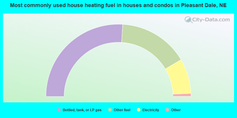
- 52.6%Bottled, tank, or LP gas
- 31.6%Other fuel
- 15.8%Electricity
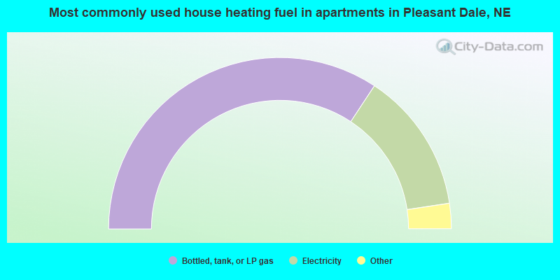
- 72.0%Bottled, tank, or LP gas
- 28.0%Electricity
Pleasant Dale compared to Nebraska state average:
- Unemployed percentage significantly below state average.
- Black race population percentage significantly below state average.
- Hispanic race population percentage significantly below state average.
- Foreign-born population percentage significantly below state average.
- Length of stay since moving in significantly above state average.
- House age above state average.
- Percentage of population with a bachelor's degree or higher below state average.

|
Total of 6 patent applications in 2008-2024.