Pownal, Maine
Submit your own pictures of this town and show them to the world
- OSM Map
- Google Map
- MSN Map
Population change since 2000: -1.1%
 |
| Males: 710 | |
| Females: 764 |
| Median resident age: | 44.6 years |
| Maine median age: | 43.0 years |
Zip codes: 04069.
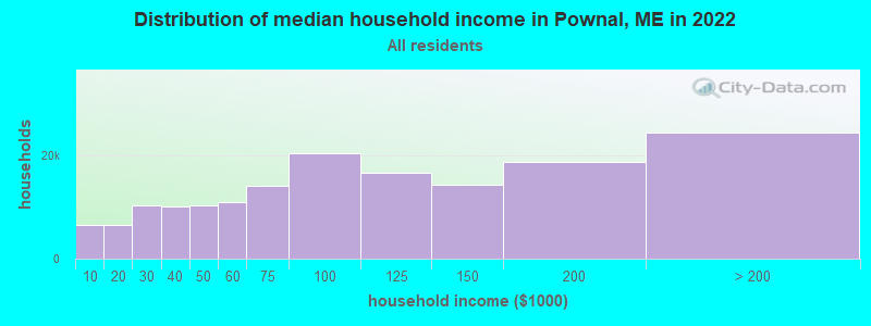
| Pownal: | $109,975 |
| ME: | $69,543 |
Estimated per capita income in 2022: $61,374 (it was $26,691 in 2000)
Pownal town income, earnings, and wages data
Estimated median house or condo value in 2022: $496,480 (it was $145,700 in 2000)
| Pownal: | $496,480 |
| ME: | $290,600 |
Mean prices in 2022: all housing units: $514,200; detached houses: $533,395; townhouses or other attached units: $572,947; in 2-unit structures: $538,406; in 3-to-4-unit structures: $462,507; in 5-or-more-unit structures: $450,834; mobile homes: $93,551
Detailed information about poverty and poor residents in Pownal, ME


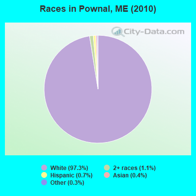
- 1,43497.3%White alone
- 161.1%Two or more races
- 110.7%Hispanic
- 60.4%Asian alone
- 40.3%Other race alone
- 10.07%Black alone
- 10.07%American Indian alone
- 10.07%Native Hawaiian and Other
Pacific Islander alone
Races in Pownal detailed stats: ancestries, foreign born residents, place of birth
 Recent articles from our blog. Our writers, many of them Ph.D. graduates or candidates, create easy-to-read articles on a wide variety of topics.
Pownal, ME City Guides:
Ancestries: English (30.0%), Irish (15.8%), French (11.9%), United States (9.7%), German (9.3%), Italian (6.8%).
Current Local Time: EST time zone
Incorporated on 03/03/1808
Land area: 22.9 square miles.
Population density: 64 people per square mile (very low).
31 residents are foreign born (0.9% Europe, 0.8% North America).
| This town: | 2.1% |
| Maine: | 2.9% |
| Pownal town: | 1.2% ($1,700) |
| Maine: | 1.5% ($1,417) |
Nearest city with pop. 50,000+: Portland, ME  (17.7 miles , pop. 64,249).
Nearest city with pop. 200,000+: Boston, MA (119.3 miles , pop. 589,141).
Nearest city with pop. 1,000,000+: Bronx, NY (283.8 miles , pop. 1,332,650).
Nearest cities:
), ), ), ), Latitude: 43.91 N, Longitude: 70.18 W
Area code: 207
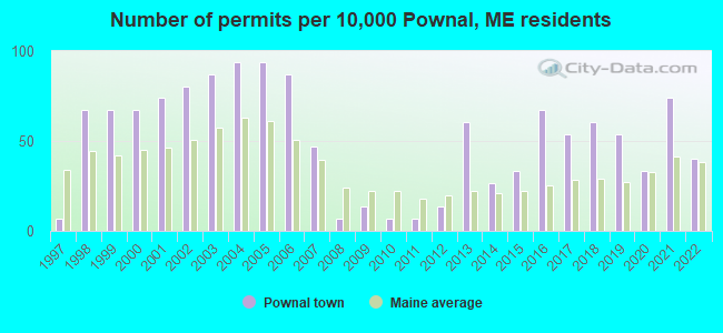
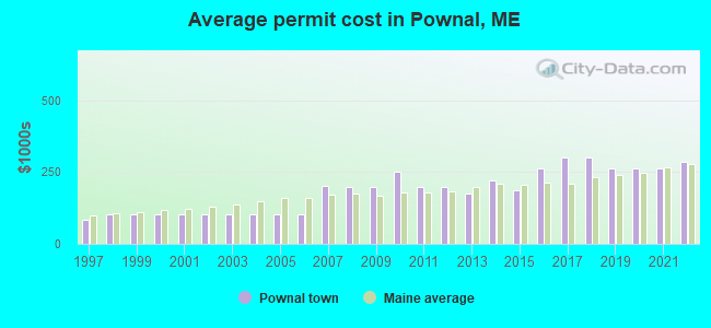
Single-family new house construction building permits:
- 2022: 6 buildings, average cost: $286,600
- 2021: 11 buildings, average cost: $262,500
- 2020: 5 buildings, average cost: $265,300
- 2019: 8 buildings, average cost: $262,400
- 2018: 9 buildings, average cost: $300,000
- 2017: 8 buildings, average cost: $300,000
- 2016: 10 buildings, average cost: $261,800
- 2015: 5 buildings, average cost: $185,000
- 2014: 4 buildings, average cost: $220,000
- 2013: 9 buildings, average cost: $173,900
- 2012: 2 buildings, average cost: $200,000
- 2011: 1 building, cost: $200,000
- 2010: 1 building, cost: $250,000
- 2009: 2 buildings, average cost: $200,000
- 2008: 1 building, cost: $200,000
- 2007: 7 buildings, average cost: $203,800
- 2006: 13 buildings, average cost: $101,700
- 2005: 14 buildings, average cost: $101,700
- 2004: 14 buildings, average cost: $101,700
- 2003: 13 buildings, average cost: $101,700
- 2002: 12 buildings, average cost: $101,700
- 2001: 11 buildings, average cost: $101,700
- 2000: 10 buildings, average cost: $101,700
- 1999: 10 buildings, average cost: $101,700
- 1998: 10 buildings, average cost: $101,700
- 1997: 1 building, cost: $84,100
| Here: | 2.1% |
| Maine: | 3.4% |
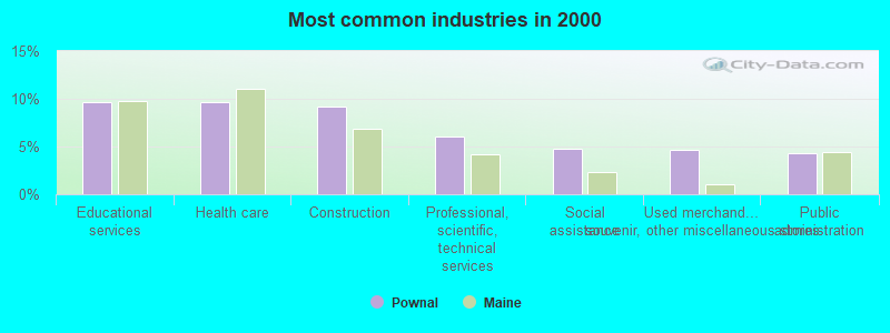
- Educational services (9.7%)
- Health care (9.7%)
- Construction (9.2%)
- Professional, scientific, technical services (6.1%)
- Social assistance (4.7%)
- Used merchandise, gift, novelty, souvenir, other miscellaneous stores (4.6%)
- Public administration (4.4%)
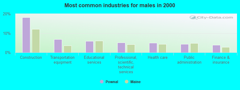
- Construction (18.1%)
- Transportation equipment (6.8%)
- Educational services (5.9%)
- Professional, scientific, technical services (5.1%)
- Health care (4.9%)
- Public administration (4.4%)
- Finance & insurance (3.9%)
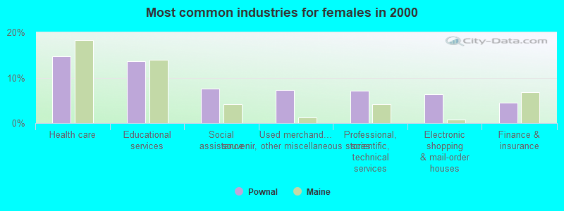
- Health care (14.7%)
- Educational services (13.7%)
- Social assistance (7.6%)
- Used merchandise, gift, novelty, souvenir, other miscellaneous stores (7.3%)
- Professional, scientific, technical services (7.1%)
- Electronic shopping & mail-order houses (6.3%)
- Finance & insurance (4.6%)
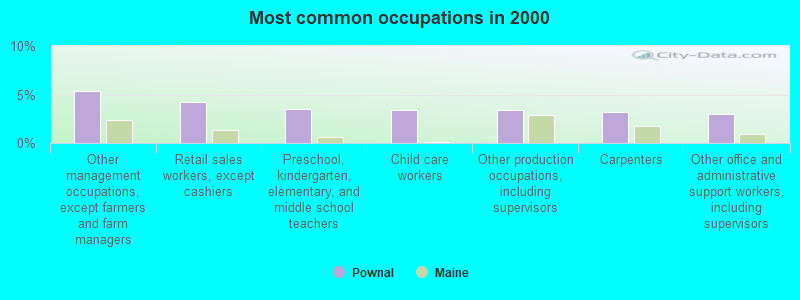
- Other management occupations, except farmers and farm managers (5.3%)
- Retail sales workers, except cashiers (4.2%)
- Preschool, kindergarten, elementary, and middle school teachers (3.5%)
- Child care workers (3.4%)
- Other production occupations, including supervisors (3.4%)
- Carpenters (3.2%)
- Other office and administrative support workers, including supervisors (3.0%)
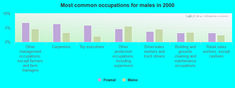
- Other management occupations, except farmers and farm managers (6.8%)
- Carpenters (6.4%)
- Top executives (5.9%)
- Other production occupations, including supervisors (4.6%)
- Driver/sales workers and truck drivers (3.7%)
- Building and grounds cleaning and maintenance occupations (3.2%)
- Retail sales workers, except cashiers (3.2%)

- Secretaries and administrative assistants (6.1%)
- Child care workers (5.8%)
- Retail sales workers, except cashiers (5.3%)
- Other office and administrative support workers, including supervisors (4.8%)
- Preschool, kindergarten, elementary, and middle school teachers (4.3%)
- Registered nurses (4.1%)
- Counselors, social workers, and other community and social service specialists (3.8%)
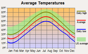
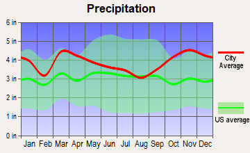
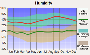
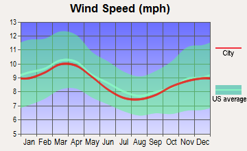
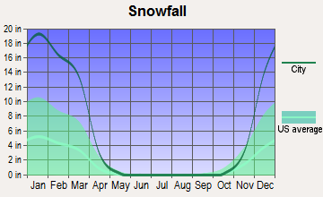
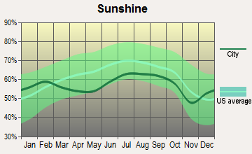
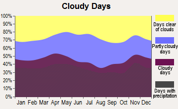
Average climate in Pownal, Maine
Based on data reported by over 4,000 weather stations
(lower is better)
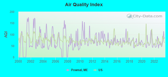
Air Quality Index (AQI) level in 2023 was 70.7. This is about average.
| City: | 70.7 |
| U.S.: | 72.6 |
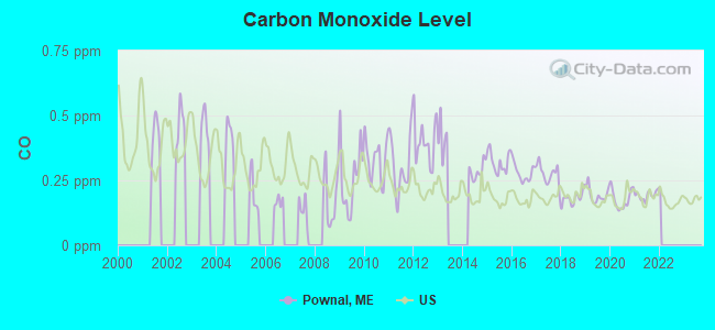
Carbon Monoxide (CO) [ppm] level in 2021 was 0.192. This is better than average. Closest monitor was 12.9 miles away from the city center.
| City: | 0.192 |
| U.S.: | 0.251 |
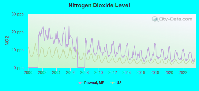
Nitrogen Dioxide (NO2) [ppb] level in 2023 was 5.47. This is about average. Closest monitor was 12.9 miles away from the city center.
| City: | 5.47 |
| U.S.: | 5.11 |
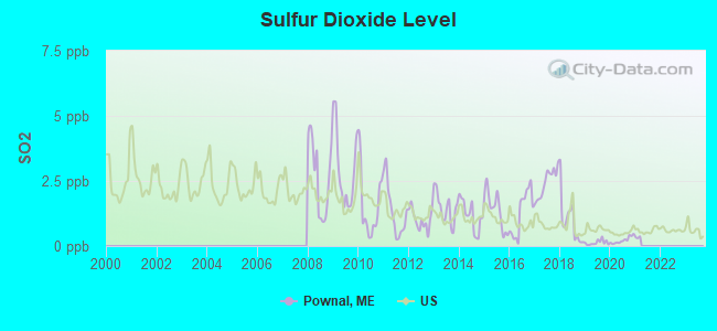
Sulfur Dioxide (SO2) [ppb] level in 2020 was 0.222. This is significantly better than average. Closest monitor was 5.2 miles away from the city center.
| City: | 0.222 |
| U.S.: | 1.515 |
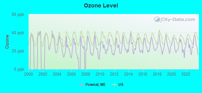
Ozone [ppb] level in 2023 was 27.8. This is about average. Closest monitor was 1.9 miles away from the city center.
| City: | 27.8 |
| U.S.: | 33.3 |
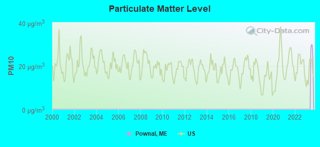
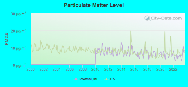
Particulate Matter (PM2.5) [µg/m3] level in 2023 was 6.01. This is better than average. Closest monitor was 12.4 miles away from the city center.
| City: | 6.01 |
| U.S.: | 8.11 |
Earthquake activity:
Pownal-area historical earthquake activity is significantly above Maine state average. It is 75% smaller than the overall U.S. average.On 10/16/2012 at 23:12:25, a magnitude 4.7 (4.7 ML, Depth: 10.0 mi, Class: Light, Intensity: IV - V) earthquake occurred 32.3 miles away from Pownal center
On 4/20/2002 at 10:50:47, a magnitude 5.3 (5.3 ML, Depth: 3.0 mi, Class: Moderate, Intensity: VI - VII) earthquake occurred 179.3 miles away from the city center
On 4/20/2002 at 10:50:47, a magnitude 5.2 (5.2 MB, 4.2 MS, 5.2 MW, 5.0 MW) earthquake occurred 179.9 miles away from Pownal center
On 1/19/1982 at 00:14:42, a magnitude 4.7 (4.5 MB, 4.7 MD, 4.5 LG) earthquake occurred 76.6 miles away from Pownal center
On 10/7/1983 at 10:18:46, a magnitude 5.3 (5.1 MB, 5.3 LG, 5.1 ML) earthquake occurred 207.4 miles away from the city center
On 2/26/1999 at 03:38:43, a magnitude 3.8 (3.8 LG, Depth: 2.0 mi, Class: Light, Intensity: II - III) earthquake occurred 51.1 miles away from Pownal center
Magnitude types: regional Lg-wave magnitude (LG), body-wave magnitude (MB), duration magnitude (MD), local magnitude (ML), surface-wave magnitude (MS), moment magnitude (MW)
Natural disasters:
The number of natural disasters in Cumberland County (33) is a lot greater than the US average (15).Major Disasters (Presidential) Declared: 22
Emergencies Declared: 10
Causes of natural disasters: Floods: 19, Storms: 13, Snows: 7, Winter Storms: 6, Heavy Rains: 3, Hurricanes: 3, Winds: 3, Blizzard: 1, Ice Storm: 1, Mudslide: 1, Snowfall: 1, Snowstorm: 1, Tornado: 1, Other: 2 (Note: some incidents may be assigned to more than one category).
Hospitals and medical centers in Pownal:
Other hospitals and medical centers near Pownal:
- FREEPORT NURSING AND REHAB CENTER (Nursing Home, about 6 miles away; FREEPORT, ME)
- BRENTWOOD REHAB AND NURSING CENTER (Nursing Home, about 9 miles away; YARMOUTH, ME)
- LAMP NURSING HOME (Nursing Home, about 10 miles away; LISBON, ME)
- MID COAST SENIOR HEALTH CENTER (Nursing Home, about 10 miles away; BRUNSWICK, ME)
- HORIZONS LIVING AND REHAB CENTER (Nursing Home, about 10 miles away; BRUNSWICK, ME)
- COMMUNITY HEALTH AND NURSING SERVICES (Home Health Center, about 10 miles away; BRUNSWICK, ME)
- DIONNE COMMONS (Nursing Home, about 10 miles away; BRUNSWICK, ME)
Colleges/universities with over 2000 students nearest to Pownal:
- Saint Joseph's College of Maine (about 17 miles; Standish, ME; Full-time enrollment: 2,010)
- University of Southern Maine (about 18 miles; Portland, ME; FT enrollment: 6,647)
- Southern Maine Community College (about 19 miles; South Portland, ME; FT enrollment: 4,666)
- University of New England (about 34 miles; Biddeford, ME; FT enrollment: 4,539)
- University of Maine at Augusta (about 36 miles; Augusta, ME; FT enrollment: 3,204)
- University of Maine at Farmington (about 53 miles; Farmington, ME; FT enrollment: 2,036)
- University of New Hampshire-Main Campus (about 66 miles; Durham, NH; FT enrollment: 15,243)
Public elementary/middle school in Pownal:
- POWNAL ELEMENTARY SCHOOL (Location: 587 ELMWOOD ROAD, Grades: PK-5)
Points of interest:
Notable locations in Pownal: Blueberry Pond Observatory (A), Blueberry Pond Campground (B), Pownal Fire and Rescue Center Station (C), Pownal Fire and Rescue North Station (D). Display/hide their locations on the map
Cemeteries: Merrill Cemetery (1), Maplewood Cemetery (2), Lake Cemetery (3), Elmwood Cemetery (4), Old Friends Cemetery (5). Display/hide their locations on the map
Streams, rivers, and creeks: Thoits Branch (A), Collins Brook (B). Display/hide their locations on the map
Park in Pownal: Bradbury Mountain State Park (1). Display/hide its location on the map
Drinking water stations with addresses in Pownal and their reported violations in the past:
BLUEBERRY POND CG (Population served: 123, Groundwater):Past health violations:POWNAL CENTER WATER ASSOC (Population served: 25, Groundwater):Past monitoring violations:
- MCL, Acute (TCR) - In AUG-2005, Contaminant: Coliform. Follow-up actions: St Tech Assistance Visit (SEP-02-2005), St Violation/Reminder Notice (SEP-02-2005), St Public Notif requested (SEP-02-2005), St Boil Water Order (SEP-02-2005), St Compliance Meeting conducted (SEP-02-2005), St Public Notif received (2 times from SEP-22-2005 to SEP-22-2005), St Compliance achieved (AUG-19-2008)
- 2 routine major monitoring violations
- 2 regular monitoring violations
Past monitoring violations:
- 2 routine major monitoring violations
- 3 regular monitoring violations
| This town: | 2.5 people |
| Maine: | 2.3 people |
| This town: | 71.5% |
| Whole state: | 62.9% |
| This town: | 8.1% |
| Whole state: | 9.4% |
Likely homosexual households (counted as self-reported same-sex unmarried-partner households)
- Lesbian couples: 1.2% of all households
- Gay men: 0.2% of all households
| This town: | 4.3% |
| Whole state: | 10.9% |
| This town: | 1.7% |
| Whole state: | 4.1% |
For population 15 years and over in Pownal:
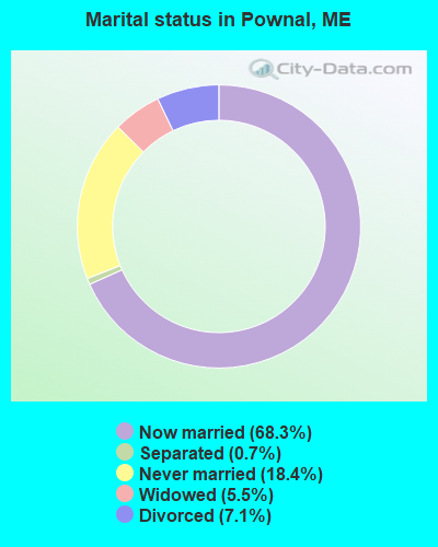
- Never married: 18.4%
- Now married: 68.3%
- Separated: 0.7%
- Widowed: 5.5%
- Divorced: 7.1%
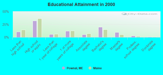
For population 25 years and over in Pownal:
- High school or higher: 89.5%
- Bachelor's degree or higher: 33.9%
- Graduate or professional degree: 14.0%
- Unemployed: 4.2%
- Mean travel time to work (commute): 26.7 minutes
| Here: | 11.4 |
| Maine average: | 11.2 |
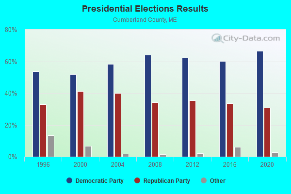
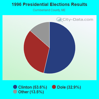
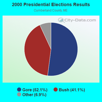


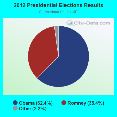


Graphs represent county-level data. Detailed 2008 Election Results
Religion statistics for Pownal, ME (based on Cumberland County data)
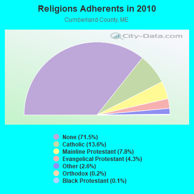
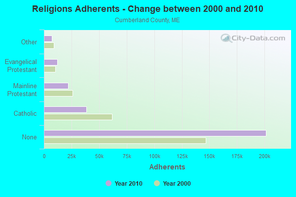
| Religion | Adherents | Congregations |
|---|---|---|
| Catholic | 38,243 | 19 |
| Mainline Protestant | 22,030 | 96 |
| Evangelical Protestant | 12,007 | 85 |
| Other | 7,187 | 44 |
| Orthodox | 500 | 1 |
| Black Protestant | 285 | 2 |
| None | 201,422 | - |
Food Environment Statistics:
| Cumberland County: | 2.62 / 10,000 pop. |
| Maine: | 2.80 / 10,000 pop. |
| Cumberland County: | 0.11 / 10,000 pop. |
| Maine: | 0.14 / 10,000 pop. |
| Cumberland County: | 2.44 / 10,000 pop. |
| State: | 2.20 / 10,000 pop. |
| Cumberland County: | 3.82 / 10,000 pop. |
| Maine: | 5.75 / 10,000 pop. |
| Cumberland County: | 12.01 / 10,000 pop. |
| State: | 11.02 / 10,000 pop. |
| Cumberland County: | 7.1% |
| Maine: | 8.2% |
| Cumberland County: | 19.5% |
| Maine: | 25.0% |
Strongest AM radio stations in Pownal:
- WGAN (560 AM; 5 kW; PORTLAND, ME; Owner: SAGA COMMUNICATIONS OF NEW ENGLAND, LLC)
- WLAM (1470 AM; 5 kW; LEWISTON, ME; Owner: RADIO PARTNERS OF MAINE, L.P.)
- WMTW (870 AM; 10 kW; GORHAM, ME; Owner: RADIO PARTNERS OF MAINE, L.P.)
- WLOB (1310 AM; 5 kW; PORTLAND, ME; Owner: ATLANTIC COAST RADIO, LLC)
- WJJB (900 AM; 1 kW; BRUNSWICK, ME; Owner: ATLANTIC COAST RADIO, LLC)
- WZAN (970 AM; 5 kW; PORTLAND, ME; Owner: SAGA COMMUNICATIONS OF NEW ENGLAND, LLC)
- WJAE (1440 AM; 5 kW; WESTBROOK, ME; Owner: ALTANTIC COAST RADIO, LLC)
- WTME (780 AM; 10 kW; RUMFORD, ME; Owner: MOUNTAIN VALLEY BROADCASTING, INC.)
- WRKO (680 AM; 50 kW; BOSTON, MA; Owner: ENTERCOM BOSTON LICENSE, LLC)
- WJTO (730 AM; 1 kW; BATH, ME; Owner: BLUE JEY BROADCASTING COMPANY)
- WFAU (1280 AM; 5 kW; GARDINER, ME; Owner: CAPSTAR TX LIMITED PARTNERSHIP)
- WCNM (1240 AM; 1 kW; LEWISTON, ME; Owner: CHRISTIAN FAMILY RADIO, INC.)
- WEEI (850 AM; 50 kW; BOSTON, MA; Owner: ENTERCOM BOSTON LICENSE, LLC)
Strongest FM radio stations in Pownal:
- WTHT (107.5 FM; LEWISTON, ME; Owner: RADIO PARTNERS OF MAINE, L.P.)
- WMEK-FM (99.9 FM; AUBURN, ME; Owner: RADIO PARTNERS OF MAINE, L.P.)
- WJBQ (97.9 FM; PORTLAND, ME; Owner: CITADEL BROADCASTING COMPANY)
- WBLM (102.9 FM; PORTLAND, ME; Owner: CITADEL BROADCASTING COMPANY)
- WMTW-FM (106.7 FM; NORTH WINDHAM, ME; Owner: RADIO PARTNERS OF MAINE, L.P.)
- WJJB-FM (95.5 FM; TOPSHAM, ME; Owner: ATLANTIC COAST RADIO, LLC)
- WCLZ (98.9 FM; BRUNSWICK, ME; Owner: CITADEL BROADCASTING COMPANY)
- WMEA (90.1 FM; PORTLAND, ME; Owner: MAINE PUBLIC BROADCASTING CORPORATION)
- WPOR (101.9 FM; PORTLAND, ME; Owner: SAGA COMMUNICATIONS OF NEW ENGLAND, LLC)
- WMSJ (89.3 FM; FREEPORT, ME; Owner: DOWNEAST CHRISTIAN COMMUNICATIONS)
- WPKQ (103.7 FM; NORTH CONWAY, NH; Owner: CITADEL BROADCASTING COMPANY)
- WHOM (94.9 FM; MT. WASHINGTON, NH; Owner: CITADEL BROADCASTING COMPANY)
- WCYI (93.9 FM; LEWISTON, ME; Owner: CITADEL BROADCASTING COMPANY)
- WBCI (105.9 FM; BATH, ME; Owner: BLOUNT COMMUNICATIONS, INC.)
- WMGX (93.1 FM; PORTLAND, ME; Owner: SAGA COMMUNICATIONS OF NEW ENGLAND, LLC)
- WYNZ (100.9 FM; WESTBROOK, ME; Owner: SAGA COMMUNICATIONS OF NEW ENGLAND, LLC)
- WSCY (106.9 FM; MOULTONBOROUGH, NH; Owner: NORTHEAST COMMUNICATIONS CORPORATION)
- WYFP (91.9 FM; HARPSWELL, ME; Owner: BIBLE BROADCASTING NETWORK, INC.)
- WLOB-FM (96.3 FM; RUMFORD, ME; Owner: ATLANTIC COAST RADIO, LLC)
- WCYY (94.3 FM; BIDDEFORD, ME; Owner: CITADEL BROADCASTING COMPANY)
TV broadcast stations around Pownal:
- WGME-TV (Channel 13; PORTLAND, ME; Owner: WGME LICENSEE, LLC)
- WPXT (Channel 51; PORTLAND, ME; Owner: HMW, INC.)
- WPME (Channel 35; LEWISTON, ME; Owner: KB PRIME MEDIA LLC)
- W32CA (Channel 32; PORTLAND, ME; Owner: NATIONAL MINORITY T.V., INC.)
- WMTW-TV (Channel 8; POLAND SPRING, ME; Owner: WMTW BROADCAST GROUP, LLC)
- WCSH (Channel 6; PORTLAND, ME; Owner: PACIFIC AND SOUTHERN COMPANY, INC.)
- WPFO (Channel 23; WATERVILLE, ME; Owner: CMCG PORTLAND LICENSE LLC)
- WCBB (Channel 10; AUGUSTA, ME; Owner: MAINE PUBLIC BROADCASTING CORP.)
- WMEA-TV (Channel 26; BIDDEFORD, ME; Owner: MAINE PUBLIC BROADCASTING CORP.)
- W58CM (Channel 58; BANGOR, ME; Owner: MS COMMUNICATIONS, LLC)
- W57AP (Channel 57; FALMOUTH, ME; Owner: SHERWOOD H. CRAIG)
- WLLB-LP (Channel 15; PORTLAND, ME; Owner: CARTER BROADCASTING CORPORATION)
- W29CA (Channel 29; BRUNSWICK, ME; Owner: CRAIG MINISTRIES)
- Pownal, Maine
- Fatal accident count13
- Vehicles involved in fatal accidents17
- Fatal accidents involving drunk persons:7
- Fatalities13
- Persons involved in fatal accidents23
- Pedestrians involved in fatal accidents0
- Maine average
- Fatal accident count1958
- Vehicles involved in fatal accidents2717
- Fatal accidents involving drunk persons672
- Fatalities2171
- Persons involved in fatal accidents4662
- Pedestrians involved in fatal accidents99
- National Bridge Inventory (NBI) Statistics
- 5Number of bridges
- 13ft / 3.9mTotal length
- 906,763Total average daily traffic
- 45,338Total average daily truck traffic
FCC Registered Antenna Towers:
7- Mark L Gartley, 153 Hallowell Road (Lat: 43.877056 Lon: -70.196500), Type: 32.0, Overall height: 30.4 m, Registrant: Holland & Knight LLP, Pconnolly@hklaw.Com, , Washi-ngton, Phone: (202) 862-5989
- Mark L Gartley, 153 Hallowell Road (Lat: 43.877056 Lon: -70.196500), Type: 32.0, Overall height: 30.4 m, Registrant: United States Cellular Corporation, Renee.Mazur@uscellular.Com, , Chica-go, Phone: (773) 399-8900
- Mark L Gartley, 153 Hallowell Road (Lat: 43.877056 Lon: -70.196500), Type: 47.2, Overall height: 45.7 m, Registrant: Holland & Knight LLP, Pconnolly@hklaw.Com, , Washi-ngton, Phone: (202) 862-5989
- Erik Brooks, 153 Hallowell Road (Lat: 43.877056 Lon: -70.196500), Type: 47.2, Overall height: 45.7 m, Registrant: Holland & Knight LLP, Pconnolly@hklaw.Com, , Washi-ngton, Phone: (202) 862-5989
- Cayla Gamble, 153 Hallowell Road (Lat: 43.877056 Lon: -70.196500), Type: 47.2, Structure height: 23005 m, Overall height: 45.7 m, Registrant: Wilkinson Barker Knauer, LLP, Gwerner@wbklaw.Com, , Washi-ngton, Phone: (202) 383-3420
- Cayla Gamble, 167 Hallowell Rd (Lat: 43.877083 Lon: -70.196528), Type: 47.2, Structure height: 23005 m, Overall height: 45.7 m, Registrant: Wilkinson Barker Knauer, LLP, Gwerner@wbklaw.Com, , Washi-ngton, Phone: (202) 383-3420
- Cayla Gamble, 167 Hallowell Rd (Lat: 43.877083 Lon: -70.196528), Type: 47.2, Structure height: 23005 m, Overall height: 45.7 m, Registrant: Wilkinson Barker Knauer, LLP, Gwerner@wbklaw.Com, , Washi-ngton, Phone: (202) 383-3420
FCC Registered Amateur Radio Licenses:
15 (See the full list of FCC Registered Amateur Radio Licenses in Pownal)FAA Registered Aircraft:
1- Aircraft: PIPER J3C-65 (Category: Land, Seats: 2, Weight: Up to 12,499 Pounds, Speed: 67 mph), Engine: CONT MOTOR A&C65 SERIES (65 HP) (Reciprocating)
N-Number: 3921A, N3921A, N-3921A, Serial Number: 9391, Year manufactured: 1943, Airworthiness Date: 05/18/1956, Certificate Issue Date: 01/25/1990
Registrant (Individual): Frederick C Weir, 73 Fickett Rd, Pownal, ME 04069
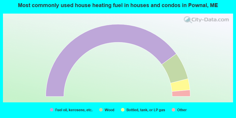
- 79.9%Fuel oil, kerosene, etc.
- 12.2%Wood
- 5.0%Bottled, tank, or LP gas
- 2.5%Electricity
- 0.4%Utility gas
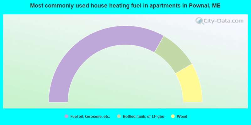
- 66.7%Fuel oil, kerosene, etc.
- 16.7%Bottled, tank, or LP gas
- 16.7%Wood
Pownal compared to Maine state average:
- Median household income above state average.
- Median house value above state average.
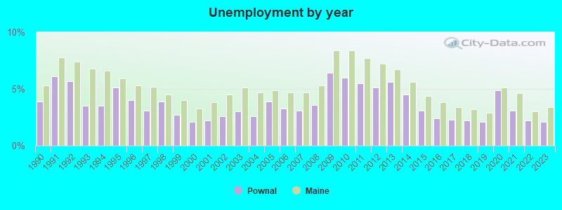
- Unemployed percentage significantly below state average.
- Black race population percentage significantly below state average.
- Hispanic race population percentage below state average.
- Foreign-born population percentage below state average.
- Renting percentage significantly below state average.
- Length of stay since moving in significantly above state average.
- Number of rooms per house significantly below state average.
- House age significantly below state average.

|
Total of 10 patent applications in 2008-2024.