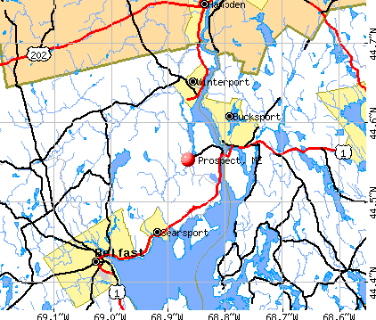
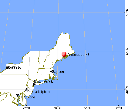
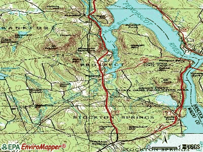
Prospect, Maine
Submit your own pictures of this town and show them to the world
- OSM Map
- General Map
- Google Map
- MSN Map
Population change since 2000: +10.4%
 |
| Males: 366 | |
| Females: 343 |
| Median resident age: | 44.3 years |
| Maine median age: | 43.0 years |
Zip codes: 04981.
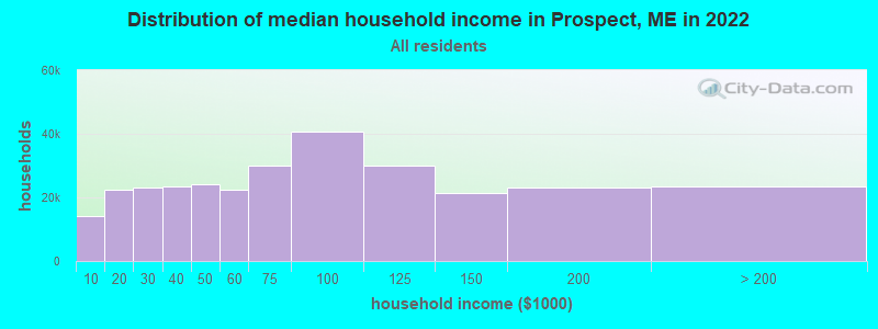
| Prospect: | $68,807 |
| ME: | $69,543 |
Estimated per capita income in 2022: $42,949 (it was $20,243 in 2000)
Prospect town income, earnings, and wages data
Estimated median house or condo value in 2022: $241,240 (it was $82,600 in 2000)
| Prospect: | $241,240 |
| ME: | $290,600 |
Mean prices in 2022: all housing units: $270,070; detached houses: $293,055; townhouses or other attached units: $325,130; in 2-unit structures: $297,158; in 3-to-4-unit structures: $211,194; in 5-or-more-unit structures: $284,526; mobile homes: $128,233; occupied boats, rvs, vans, etc.: $21,180
Detailed information about poverty and poor residents in Prospect, ME


- 69698.2%White alone
- 50.7%Two or more races
- 30.4%American Indian alone
- 20.3%Black alone
- 20.3%Hispanic
- 10.1%Asian alone
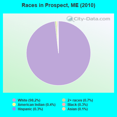
Races in Prospect detailed stats: ancestries, foreign born residents, place of birth
According to our research of Maine and other state lists, there were 3 registered sex offenders living in Prospect, Maine as of April 19, 2024.
The ratio of all residents to sex offenders in Prospect is 236 to 1.
 Recent articles from our blog. Our writers, many of them Ph.D. graduates or candidates, create easy-to-read articles on a wide variety of topics.

 | Small Houses Part 3 (111 replies) |
| Looking for rentals in Southern Maine (2 replies) |
| Bill submitted to allow Maine gun owners to carry concealed without permit (296 replies) |
| Free state park resident's day June 18 (4 replies) |
| Finally! A serious Maine Winter... (132 replies) |
| Vacation in Milbridge area (17 replies) |
Latest news from Prospect, ME collected exclusively by city-data.com from local newspapers, TV, and radio stations
Prospect, ME City Guides:
Ancestries: English (27.1%), United States (18.7%), Irish (18.1%), French (8.9%), German (5.0%), French Canadian (3.7%).
Current Local Time: EST time zone
Incorporated on 02/24/1794
Elevation: 96 feet
Land area: 18.1 square miles.
Population density: 39 people per square mile (very low).
4 residents are foreign born
| This town: | 0.6% |
| Maine: | 2.9% |
| Prospect town: | 1.2% ($973) |
| Maine: | 1.5% ($1,417) |
Nearest city with pop. 50,000+: Portland, ME  (92.7 miles , pop. 64,249).
Nearest city with pop. 200,000+: Boston, MA (190.3 miles , pop. 589,141).
Nearest city with pop. 1,000,000+: Bronx, NY (360.9 miles , pop. 1,332,650).
Nearest cities:
), ), ), Latitude: 44.55 N, Longitude: 68.87 W
Area code commonly used in this area: 207

| Here: | 3.2% |
| Maine: | 3.4% |
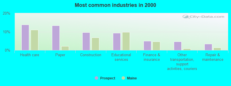
- Health care (13.9%)
- Paper (13.3%)
- Construction (9.5%)
- Educational services (9.2%)
- Finance & insurance (4.9%)
- Other transportation, support activities, couriers (4.6%)
- Repair & maintenance (3.5%)
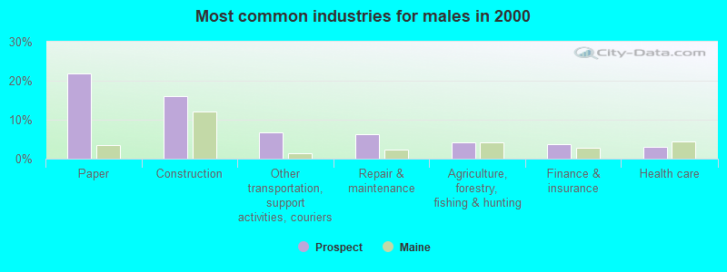
- Paper (21.8%)
- Construction (16.1%)
- Other transportation, support activities, couriers (6.7%)
- Repair & maintenance (6.2%)
- Agriculture, forestry, fishing & hunting (4.1%)
- Finance & insurance (3.6%)
- Health care (3.1%)
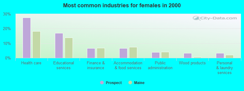
- Health care (27.5%)
- Educational services (17.0%)
- Finance & insurance (6.5%)
- Accommodation & food services (6.5%)
- Public administration (3.9%)
- Wood products (3.3%)
- Personal & laundry services (3.3%)
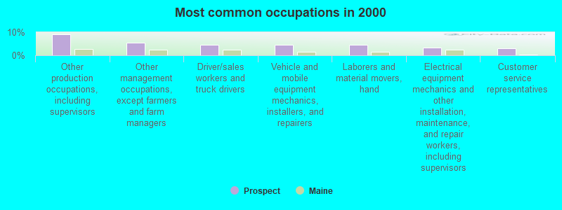
- Other production occupations, including supervisors (9.0%)
- Other management occupations, except farmers and farm managers (5.5%)
- Driver/sales workers and truck drivers (4.6%)
- Vehicle and mobile equipment mechanics, installers, and repairers (4.6%)
- Laborers and material movers, hand (4.6%)
- Electrical equipment mechanics and other installation, maintenance, and repair workers, including supervisors (3.5%)
- Customer service representatives (3.2%)
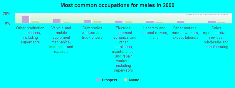
- Other production occupations, including supervisors (16.1%)
- Vehicle and mobile equipment mechanics, installers, and repairers (8.3%)
- Driver/sales workers and truck drivers (7.3%)
- Electrical equipment mechanics and other installation, maintenance, and repair workers, including supervisors (6.2%)
- Laborers and material movers, hand (5.2%)
- Other material moving workers, except laborers (5.2%)
- Sales representatives, services, wholesale and manufacturing (4.7%)

- Other management occupations, except farmers and farm managers (7.8%)
- Registered nurses (7.2%)
- Customer service representatives (5.9%)
- Nursing, psychiatric, and home health aides (5.2%)
- Information and record clerks, except customer service representatives (5.2%)
- Preschool, kindergarten, elementary, and middle school teachers (4.6%)
- Building and grounds cleaning and maintenance occupations (4.6%)
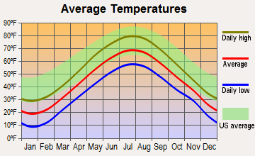
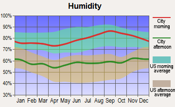
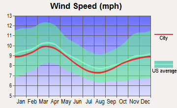
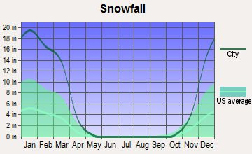
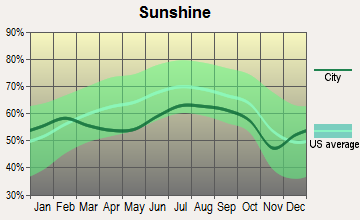
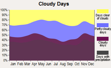
Average climate in Prospect, Maine
Based on data reported by over 4,000 weather stations
(lower is better)
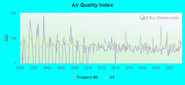
Air Quality Index (AQI) level in 2023 was 61.1. This is about average.
| City: | 61.1 |
| U.S.: | 72.6 |
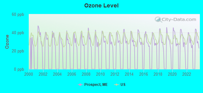
Ozone [ppb] level in 2023 was 33.6. This is about average. Closest monitor was 9.5 miles away from the city center.
| City: | 33.6 |
| U.S.: | 33.3 |
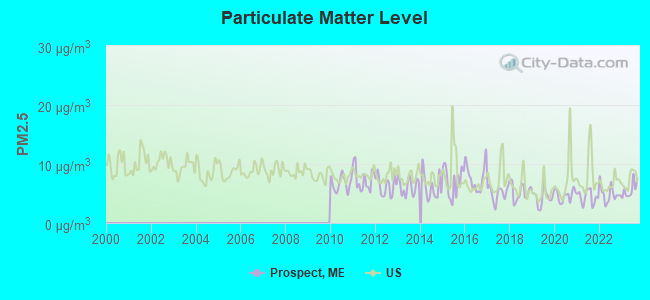
Particulate Matter (PM2.5) [µg/m3] level in 2023 was 5.62. This is significantly better than average. Closest monitor was 17.8 miles away from the city center.
| City: | 5.62 |
| U.S.: | 8.11 |
Earthquake activity:
Prospect-area historical earthquake activity is significantly above Maine state average. It is 79% smaller than the overall U.S. average.On 10/16/2012 at 23:12:25, a magnitude 4.7 (4.7 ML, Depth: 10.0 mi, Class: Light, Intensity: IV - V) earthquake occurred 110.6 miles away from Prospect center
On 4/20/2002 at 10:50:47, a magnitude 5.3 (5.3 ML, Depth: 3.0 mi, Class: Moderate, Intensity: VI - VII) earthquake occurred 238.0 miles away from the city center
On 4/20/2002 at 10:50:47, a magnitude 5.2 (5.2 MB, 4.2 MS, 5.2 MW, 5.0 MW) earthquake occurred 239.1 miles away from the city center
On 1/19/1982 at 00:14:42, a magnitude 4.7 (4.5 MB, 4.7 MD, 4.5 LG) earthquake occurred 154.0 miles away from the city center
On 10/7/1983 at 10:18:46, a magnitude 5.3 (5.1 MB, 5.3 LG, 5.1 ML) earthquake occurred 274.2 miles away from Prospect center
On 2/26/1999 at 03:38:43, a magnitude 3.8 (3.8 LG, Depth: 2.0 mi, Class: Light, Intensity: II - III) earthquake occurred 32.4 miles away from the city center
Magnitude types: regional Lg-wave magnitude (LG), body-wave magnitude (MB), duration magnitude (MD), local magnitude (ML), surface-wave magnitude (MS), moment magnitude (MW)
Natural disasters:
The number of natural disasters in Waldo County (19) is greater than the US average (15).Major Disasters (Presidential) Declared: 15
Emergencies Declared: 3
Causes of natural disasters: Floods: 14, Storms: 11, Snows: 3, Heavy Rains: 2, Winter Storms: 2, Blizzard: 1, Hurricane: 1, Ice Storm: 1, Landslide: 1, Snowfall: 1, Wind: 1, Other: 1 (Note: some incidents may be assigned to more than one category).
Hospitals and medical centers near Prospect:
- HARBOR HILL CENTER (Nursing Home, about 11 miles away; BELFAST, ME)
- BRADBURY MANOR (Nursing Home, about 12 miles away; BELFAST, ME)
- THE COMMONS AT TALL PINES (Nursing Home, about 12 miles away; BELFAST, ME)
- DIALYSIS CLINIC INC. - BELFAST (Dialysis Facility, about 12 miles away; BELFAST, ME)
- WALDO COUNTY GENERAL HOSPITAL Critical Access Hospitals (about 12 miles away; BELFAST, ME)
Colleges/universities with over 2000 students nearest to Prospect:
- Husson University (about 20 miles; Bangor, ME; Full-time enrollment: 2,421)
- University of Maine (about 26 miles; Orono, ME; FT enrollment: 8,931)
- University of Maine at Augusta (about 49 miles; Augusta, ME; FT enrollment: 3,204)
- University of Maine at Farmington (about 64 miles; Farmington, ME; FT enrollment: 2,036)
- Southern Maine Community College (about 93 miles; South Portland, ME; FT enrollment: 4,666)
- University of Southern Maine (about 94 miles; Portland, ME; FT enrollment: 6,647)
- Saint Joseph's College of Maine (about 95 miles; Standish, ME; FT enrollment: 2,010)
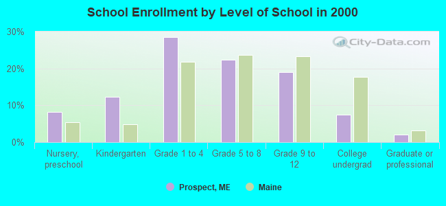
Public elementary/middle school in Prospect:
- PENINSULA SCHOOL (Location: 71 MAIN STREET, Grades: PK-8)
Points of interest:
Notable location: Prospect Volunteer Fire Department (A). Display/hide its location on the map
Lake: Halfmoon Pond (A). Display/hide its location on the map
Streams, rivers, and creeks: South Branch Marsh River (A), Main Stream (B), Hawes Stream (C), Perkins Brook (D), Lane Brook (E), Colson Stream (F), Carley Brook (G), Halfmoon Stream (H). Display/hide their locations on the map
Park in Prospect: Fort Knox State Historic Site (1). Display/hide its location on the map
Drinking water stations with addresses in Prospect and their reported violations in the past:
HERMON MOUNTAIN INC (Population served: 130, Groundwater):Past monitoring violations:
- 7 routine major monitoring violations
- 10 regular monitoring violations
| This town: | 2.4 people |
| Maine: | 2.3 people |
| This town: | 67.7% |
| Whole state: | 62.9% |
| This town: | 9.6% |
| Whole state: | 9.4% |
Likely homosexual households (counted as self-reported same-sex unmarried-partner households)
- Lesbian couples: 0.3% of all households
- Gay men: 0.3% of all households
| This town: | 10.4% |
| Whole state: | 10.9% |
| This town: | 5.0% |
| Whole state: | 4.1% |
For population 15 years and over in Prospect:
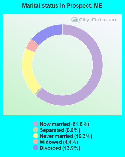
- Never married: 19.3%
- Now married: 61.6%
- Separated: 0.8%
- Widowed: 4.4%
- Divorced: 13.9%
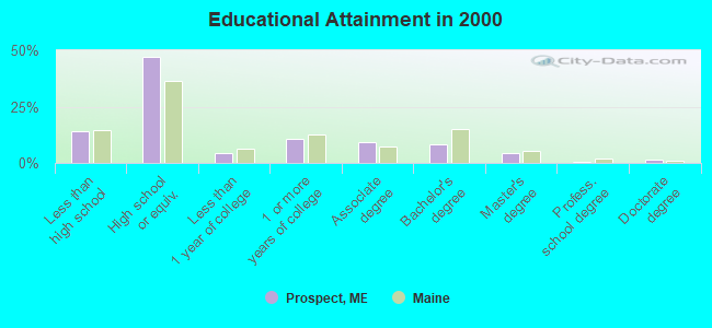
For population 25 years and over in Prospect:
- High school or higher: 86.1%
- Bachelor's degree or higher: 14.8%
- Graduate or professional degree: 6.6%
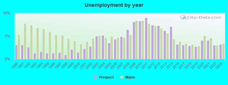
- Unemployed: 3.4%
- Mean travel time to work (commute): 32.7 minutes
| Here: | 10.4 |
| Maine average: | 11.2 |
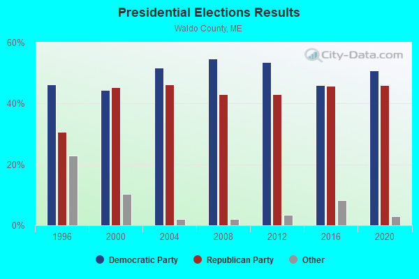
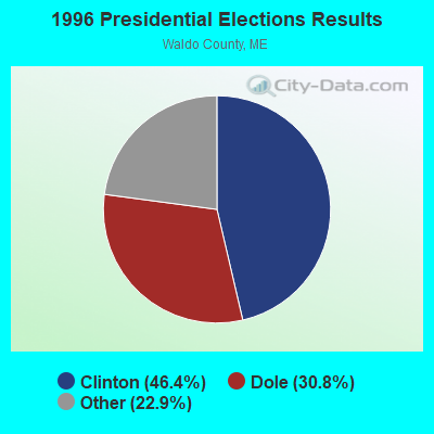
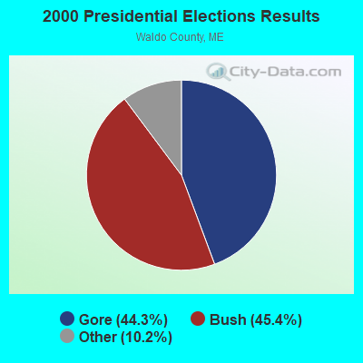


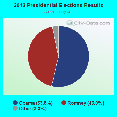

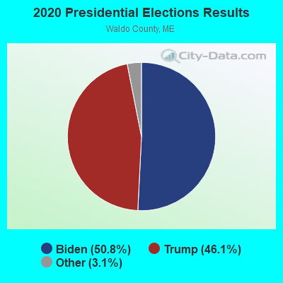
Graphs represent county-level data. Detailed 2008 Election Results
Religion statistics for Prospect, ME (based on Waldo County data)
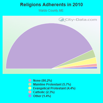
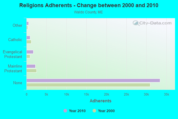
| Religion | Adherents | Congregations |
|---|---|---|
| Mainline Protestant | 2,204 | 20 |
| Evangelical Protestant | 1,711 | 23 |
| Catholic | 900 | 3 |
| Other | 554 | 7 |
| None | 33,417 | - |
Food Environment Statistics:
| Waldo County: | 2.60 / 10,000 pop. |
| State: | 2.80 / 10,000 pop. |
| Waldo County: | 1.82 / 10,000 pop. |
| State: | 2.20 / 10,000 pop. |
| This county: | 7.02 / 10,000 pop. |
| State: | 5.75 / 10,000 pop. |
| Waldo County: | 8.84 / 10,000 pop. |
| Maine: | 11.02 / 10,000 pop. |
| This county: | 9.2% |
| Maine: | 8.2% |
| This county: | 26.1% |
| State: | 25.0% |
Strongest AM radio stations in Prospect:
- WZON (620 AM; 5 kW; BANGOR, ME; Owner: THE ZONE CORPORATION)
- WABI (910 AM; 5 kW; BANGOR, ME; Owner: CLEAR CHANNEL BROADCASTING LICENSES, INC.)
- WDEA (1370 AM; 5 kW; ELLSWORTH, ME; Owner: CUMULUS LICENSING CORP.)
- WSKW (1160 AM; 10 kW; SKOWHEGAN, ME; Owner: MOUNTAIN WIRELESS, INCORPORATED)
- WRKO (680 AM; 50 kW; BOSTON, MA; Owner: ENTERCOM BOSTON LICENSE, LLC)
- WTME (780 AM; 10 kW; RUMFORD, ME; Owner: MOUNTAIN VALLEY BROADCASTING, INC.)
- WFAU (1280 AM; 5 kW; GARDINER, ME; Owner: CAPSTAR TX LIMITED PARTNERSHIP)
- WEEI (850 AM; 50 kW; BOSTON, MA; Owner: ENTERCOM BOSTON LICENSE, LLC)
- WNZS (1340 AM; 1 kW; VEAZIE, ME; Owner: WATERFRONT COMMUNICATIONS INC.)
- WBZ (1030 AM; 50 kW; BOSTON, MA; Owner: INFINITY BROADCASTING OPERATIONS, INC.)
- WCRN (830 AM; 50 kW; WORCESTER, MA; Owner: CARTER BROADCASTING CORPORATION)
- WNNZ (640 AM; 50 kW; WESTFIELD, MA; Owner: CLEAR CHANNEL BROADCASTING LICENSES, INC.)
- WMTW (870 AM; 10 kW; GORHAM, ME; Owner: RADIO PARTNERS OF MAINE, L.P.)
Strongest FM radio stations in Prospect:
- WBFB (104.7 FM; BELFAST, ME; Owner: CLEAR CHANNEL BROADCASTING LICENSES, INC.)
- WFZX (101.7 FM; SEARSPORT, ME; Owner: CLEAR CHANNEL BROADCASTING LICENSES, INC.)
- WKIT-FM (100.3 FM; BREWER, ME; Owner: THE ZONE CORPORATION)
- WWBX (97.1 FM; BANGOR, ME; Owner: CLEAR CHANNEL BROADCASTING LICENSES, INC.)
- WWMJ (95.7 FM; ELLSWORTH, ME; Owner: CUMULUS LICENSING CORP.)
- WERU-FM (89.9 FM; BLUE HILL, ME; Owner: SALT POND COMMUNITY B/C COMPANY)
- WMEH (90.9 FM; BANGOR, ME; Owner: MAINE PUBLIC BROADCASTING CORPORATION)
- WMEP (90.5 FM; CAMDEN, ME; Owner: MAINE PUBLIC BROADCASTING CORP.)
- WQSS (102.5 FM; CAMDEN, ME; Owner: CLEAR CHANNEL BROADCASTING LICENSES, INC.)
- WEZQ (92.9 FM; BANGOR, ME; Owner: CUMULUS LICENSING CORP.)
- WHCF (88.5 FM; BANGOR, ME; Owner: BANGOR BAPTIST CHURCH)
- WVOM (103.9 FM; HOWLAND, ME; Owner: CLEAR CHANNEL BROADCASTING LICENSES, INC.)
- WQCB (106.5 FM; BREWER, ME; Owner: CUMULUS LICENSING CORP.)
- WNSX (97.7 FM; WINTER HARBOR, ME; Owner: CLEAR CHANNEL BROADCASTING LICENSES, INC.)
- WMCM (103.3 FM; ROCKLAND, ME; Owner: CLEAR CHANNEL BROADCASTING LICENSES, INC.)
- WBYA (105.5 FM; ISLESBORO, ME; Owner: MARINER BROADCASTING LIMTED PARTNERSHIP)
- WLKE (99.1 FM; BAR HARBOR, ME; Owner: CLEAR CHANNEL BROADCASTING LICENSES, INC.)
- WBQX (106.9 FM; THOMASTON, ME; Owner: MARINER BROADCASTING LIMITED PARTNER)
- WBZN (107.3 FM; OLD TOWN, ME; Owner: CUMULUS LICENSING CORP.)
TV broadcast stations around Prospect:
- WABI-TV (Channel 5; BANGOR, ME; Owner: COMMUNITY BROADCASTING SERVICE)
- WCKD-LP (Channel 30; BANGOR/DEDHAM, ME; Owner: J. MCLEOD, ME FAMILY B/CING., INC.)
- W36CK (Channel 36; BANGOR, ME; Owner: TRINITY BROADCASTING NETWORK)
- WLBZ (Channel 2; BANGOR, ME; Owner: PACIFIC AND SOUTHERN COMPANY, INC.)
- WBGR-LP (Channel 33; BANGOR/DEDHAM, ME; Owner: MAINE FAMILY BROADCASTING, INC.)
- WMEB-TV (Channel 12; ORONO, ME; Owner: MAINE PUBLIC BROADCASTING CORPORATION)
- W66CL (Channel 66; BANGOR, ME; Owner: MS COMMUNICATIONS, LLC)
- National Bridge Inventory (NBI) Statistics
- 5Number of bridges
- 26ft / 7.9mTotal length
- 8,242Total average daily traffic
- 409Total average daily truck traffic
- 18,245Total future (year 2034) average daily traffic
FCC Registered Broadcast Land Mobile Towers:
1- Rte 1a (Lat: 44.510083 Lon: -68.941972), Call Sign: WQQ763, Licensee ID: L00047152,
Assigned Frequencies: 43.0200 MHz, Grant Date: 04/06/2000, Expiration Date: 06/20/2005, Cancellation Date: 04/18/2005, Registrant: The Lane Construction Corporation, 965 E Main Street, Meriden, CT 06450-6004, Phone: (203) 235-3351, Fax: (203) 237-4260
FCC Registered Amateur Radio Licenses:
3- Call Sign: N1ECP, Licensee ID: L00488206, Grant Date: 05/30/2018, Expiration Date: 07/02/2028, Certifier: William A Sneed Jr, Registrant: William A Sneed Jr, 38 Moody Rd, Prospect, ME 04981-9720
- Call Sign: N1PRM, Licensee ID: L00835654, Grant Date: 04/09/2014, Expiration Date: 04/09/2024, Certifier: Jeffrey S Baker, Registrant: Jeffrey S Baker, 122 Ward Road, Prospect, ME 04981
- Call Sign: KD9MBF, Licensee ID: L02227595, Grant Date: 11/21/2018, Expiration Date: 11/21/2028, Certifier: Heuneman C Eric, Registrant: Heuneman C Eric, 38 Bowden Point, Prospect, ME 04981
FAA Registered Aircraft:
1- Aircraft: CESSNA 180H (Category: Land, Seats: 6, Weight: Up to 12,499 Pounds, Speed: 121 mph), Engine: CONT MOTOR O-470 SERIES (230 HP) (Reciprocating)
N-Number: 7933V, N7933V, N-7933V, Serial Number: 18051833, Year manufactured: 1967, Airworthiness Date: 04/01/1986, Certificate Issue Date: 02/27/2017
Registrant (Individual): Richard J Harriman, 511 Fort Knox Rd, Prospect, ME 04981
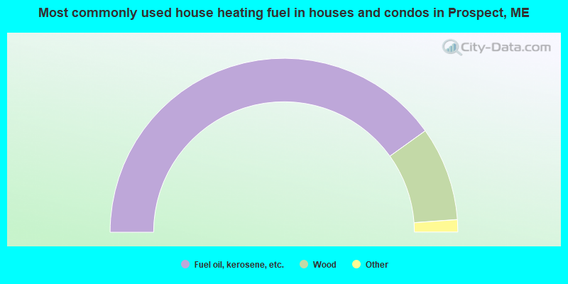
- 80.2%Fuel oil, kerosene, etc.
- 17.5%Wood
- 1.4%Bottled, tank, or LP gas
- 0.9%Electricity
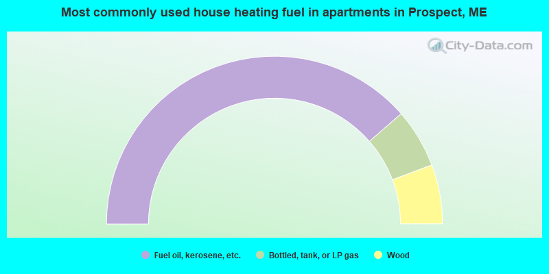
- 77.1%Fuel oil, kerosene, etc.
- 11.4%Bottled, tank, or LP gas
- 11.4%Wood
Prospect compared to Maine state average:
- Unemployed percentage significantly below state average.
- Black race population percentage significantly below state average.
- Hispanic race population percentage significantly below state average.
- Foreign-born population percentage significantly below state average.
- Renting percentage below state average.
- Length of stay since moving in significantly above state average.
- Number of rooms per house significantly below state average.
- House age significantly below state average.
- Number of college students below state average.
- Percentage of population with a bachelor's degree or higher below state average.