Round Oak, Georgia
Submit your own pictures of this place and show them to the world
- OSM Map
- General Map
- Google Map
- MSN Map

| Males: 1,841 | |
| Females: 1,742 |
| Median resident age: | 35.3 years |
| Georgia median age: | 33.4 years |
Zip code: 31038
| Round Oak: | $56,300 |
| GA: | $72,837 |
Estimated per capita income in 2022: $31,250 (it was $18,452 in 2000)
Round Oak CCD income, earnings, and wages data
Estimated median house or condo value in 2022: $151,394 (it was $62,000 in 2000)
| Round Oak: | $151,394 |
| GA: | $297,400 |
Mean prices in 2022: all housing units: $188,273; detached houses: $221,346; townhouses or other attached units: $182,213; mobile homes: $68,656
Detailed information about poverty and poor residents in Round Oak, GA


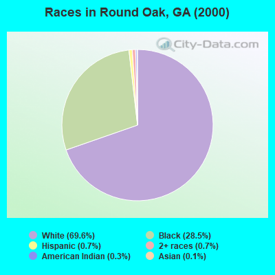
- 2,16769.6%White alone
- 88628.5%Black alone
- 220.7%Two or more races
- 230.7%Hispanic
- 80.3%American Indian alone
- 40.1%Asian alone
- 20.06%Native Hawaiian and Other
Pacific Islander alone - 10.03%Other race alone
Races in Round Oak detailed stats: ancestries, foreign born residents, place of birth
 Recent articles from our blog. Our writers, many of them Ph.D. graduates or candidates, create easy-to-read articles on a wide variety of topics.
Current Local Time: EST time zone
Elevation: 630 feet
Land area: 196.4 square miles.
Population density: 18 people per square mile (very low).

| Round Oak CCD: | 0.6% ($391) |
| Georgia: | 0.9% ($919) |
Nearest city with pop. 50,000+: Macon, GA  (17.1 miles , pop. 97,255).
Nearest city with pop. 200,000+: Atlanta, GA (65.2 miles , pop. 416,474).
Nearest city with pop. 1,000,000+: Chicago, IL (645.1 miles , pop. 2,896,016).
Nearest cities:
), ), ), ), )Latitude: 33.09 N, Longitude: 83.61 W
Area code commonly used in this area: 478

| Here: | 2.6% |
| Georgia: | 2.9% |
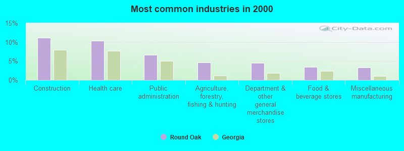
- Construction (11.2%)
- Health care (10.3%)
- Public administration (6.7%)
- Agriculture, forestry, fishing & hunting (4.6%)
- Department & other general merchandise stores (4.6%)
- Food & beverage stores (3.4%)
- Miscellaneous manufacturing (3.3%)
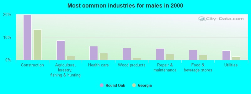
- Construction (19.9%)
- Agriculture, forestry, fishing & hunting (8.6%)
- Health care (6.1%)
- Wood products (5.2%)
- Repair & maintenance (5.1%)
- Food & beverage stores (4.4%)
- Utilities (4.1%)
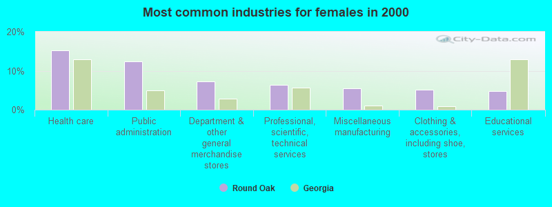
- Health care (15.3%)
- Public administration (12.3%)
- Department & other general merchandise stores (7.2%)
- Professional, scientific, technical services (6.4%)
- Miscellaneous manufacturing (5.4%)
- Clothing & accessories, including shoe, stores (5.1%)
- Educational services (4.8%)
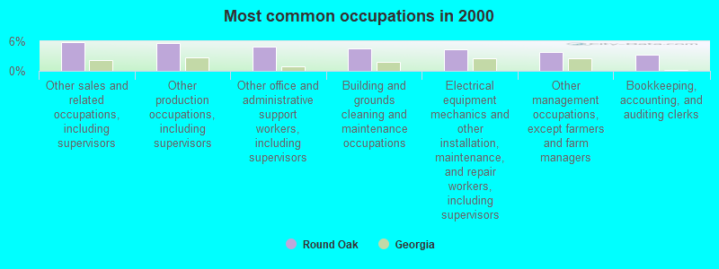
- Other sales and related occupations, including supervisors (5.8%)
- Other production occupations, including supervisors (5.7%)
- Other office and administrative support workers, including supervisors (4.9%)
- Building and grounds cleaning and maintenance occupations (4.6%)
- Electrical equipment mechanics and other installation, maintenance, and repair workers, including supervisors (4.3%)
- Other management occupations, except farmers and farm managers (3.8%)
- Bookkeeping, accounting, and auditing clerks (3.3%)
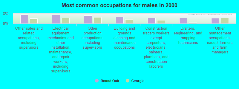
- Other sales and related occupations, including supervisors (7.3%)
- Electrical equipment mechanics and other installation, maintenance, and repair workers, including supervisors (7.1%)
- Other production occupations, including supervisors (6.6%)
- Building and grounds cleaning and maintenance occupations (5.5%)
- Construction traders workers except carpenters, electricians, painters, plumbers, and construction laborers (4.5%)
- Drafters, engineering, and mapping technicians (4.5%)
- Other management occupations, except farmers and farm managers (4.4%)
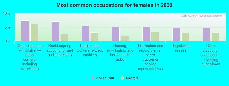
- Other office and administrative support workers, including supervisors (7.4%)
- Bookkeeping, accounting, and auditing clerks (7.1%)
- Retail sales workers, except cashiers (5.4%)
- Nursing, psychiatric, and home health aides (5.1%)
- Information and record clerks, except customer service representatives (5.1%)
- Registered nurses (4.8%)
- Other production occupations, including supervisors (4.6%)
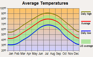
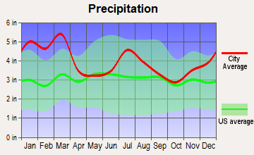
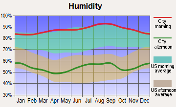
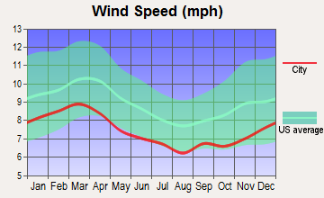
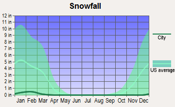
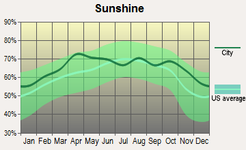
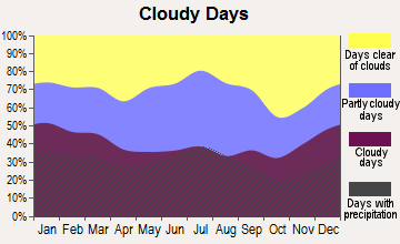
Average climate in Round Oak, Georgia
Based on data reported by over 4,000 weather stations
(lower is better)
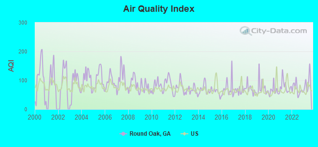
Air Quality Index (AQI) level in 2023 was 89.5. This is worse than average.
| City: | 89.5 |
| U.S.: | 72.6 |
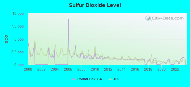
Sulfur Dioxide (SO2) [ppb] level in 2023 was 1.31. This is about average. Closest monitor was 13.0 miles away from the city center.
| City: | 1.31 |
| U.S.: | 1.51 |
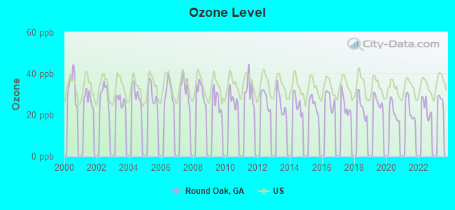
Ozone [ppb] level in 2022 was 23.4. This is significantly better than average. Closest monitor was 19.9 miles away from the city center.
| City: | 23.4 |
| U.S.: | 33.3 |

Particulate Matter (PM2.5) [µg/m3] level in 2023 was 11.2. This is worse than average. Closest monitor was 19.9 miles away from the city center.
| City: | 11.2 |
| U.S.: | 8.1 |
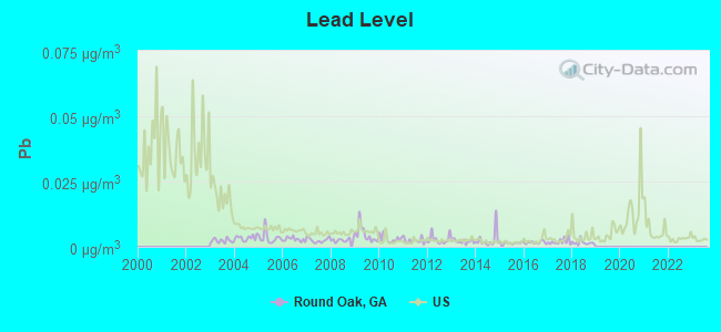
Lead (Pb) [µg/m3] level in 2018 was 0.00153. This is significantly better than average. Closest monitor was 16.9 miles away from the city center.
| City: | 0.00153 |
| U.S.: | 0.00931 |
Tornado activity:
Round Oak-area historical tornado activity is near Georgia state average. It is 16% greater than the overall U.S. average.
On 11/22/1992, a category F4 (max. wind speeds 207-260 mph) tornado 11.4 miles away from the Round Oak place center killed 5 people and injured 86 people and caused between $5,000,000 and $50,000,000 in damages.
On 4/30/1953, a category F4 tornado 33.7 miles away from the place center killed 18 people and injured 300 people and caused between $5,000,000 and $50,000,000 in damages.
Earthquake activity:
Round Oak-area historical earthquake activity is significantly above Georgia state average. It is 15% greater than the overall U.S. average.On 8/2/1974 at 08:52:09, a magnitude 4.9 (4.3 MB, 4.9 LG, Class: Light, Intensity: IV - V) earthquake occurred 84.6 miles away from the city center
On 4/29/2003 at 08:59:39, a magnitude 4.9 (4.4 MB, 4.6 MW, 4.9 LG) earthquake occurred 151.4 miles away from the city center
On 4/29/2003 at 08:59:39, a magnitude 4.6 (4.6 MW, Depth: 12.3 mi) earthquake occurred 151.4 miles away from the city center
On 11/30/1973 at 07:48:41, a magnitude 4.7 (4.7 MB, 4.6 ML) earthquake occurred 188.7 miles away from Round Oak center
On 1/18/1999 at 07:00:53, a magnitude 4.8 (4.8 MB, 4.0 LG, Depth: 0.6 mi) earthquake occurred 211.9 miles away from the city center
On 8/9/2020 at 12:07:37, a magnitude 5.1 (5.1 MW, Depth: 4.7 mi, Class: Moderate, Intensity: VI - VII) earthquake occurred 274.6 miles away from the city center
Magnitude types: regional Lg-wave magnitude (LG), body-wave magnitude (MB), local magnitude (ML), moment magnitude (MW)
Natural disasters:
The number of natural disasters in Jones County (11) is smaller than the US average (15).Major Disasters (Presidential) Declared: 7
Emergencies Declared: 3
Causes of natural disasters: Tornadoes: 3, Winter Storms: 3, Floods: 2, Heavy Rains: 2, Hurricanes: 2, Tropical Storms: 2, Drought: 1, Storm: 1, Wind: 1, Other: 1 (Note: some incidents may be assigned to more than one category).
Hospitals and medical centers near Round Oak:
- LYNN HAVEN HEALTH AND REHABILITATION (Nursing Home, about 4 miles away; GRAY, GA)
- GRAY HEALTH AND REHABILITATION (Nursing Home, about 7 miles away; GRAY, GA)
- THREE RIVERS HOME HEALTH SERVICES, INC (Home Health Center, about 13 miles away; MACON, GA)
- CARESOUTH HOMECARE PROFESSIONALS (Home Health Center, about 13 miles away; MACON, GA)
- EAST MACON HEALTH CARE FACILITY (Nursing Home, about 13 miles away; MACON, GA)
- HEARTLAND HOSPICE SERVICES ( MACON ) (Hospital, about 14 miles away; MACON, GA)
- CENTRAL GEORGIA REHABILITATION HOSPITAL, LLC (Hospital, about 14 miles away; MACON, GA)
Colleges/universities with over 2000 students nearest to Round Oak:
- Mercer University (about 18 miles; Macon, GA; Full-time enrollment: 6,297)
- Middle Georgia State College (about 21 miles; Macon, GA; FT enrollment: 7,091)
- Georgia College and State University (about 23 miles; Milledgeville, GA; FT enrollment: 6,271)
- Georgia Military College-Distance Learning Campuses (about 23 miles; Milledgeville, GA; FT enrollment: 6,438)
- Gordon State College (about 32 miles; Barnesville, GA; FT enrollment: 3,336)
- Central Georgia Technical College (about 38 miles; Warner Robins, GA; FT enrollment: 6,829)
- Southern Crescent Technical College (about 42 miles; Griffin, GA; FT enrollment: 4,168)
Points of interest:
Notable locations in Round Oak: Jarell Historical Plantation (A), Blountsville Hunt Camp (B), Round Oak Lookout (C), Grady Creek Hunt Camp (D), Hillsboro Lake Picnic Area (E), Jarrell Plantation (F), Tribble Fields (G), Uncle Remus District Headquarters (H), Hilchiti Experimental Forest Station (I), National Wildlife Refuge Headquarters (J), State Forestry Unit Headquarters (K), Jones County Station 5A (L), Jones County Fire Department Station 5A (M), Jones County Fire Department Station 5B (N). Display/hide their locations on the map
Churches in Round Oak include: Round Tree Methodist Church (A), Wayside Presbyterian Church (B), Stewart Chapel (C), Blounts Chapel (D), Saint Pauls Church (E), Bethesda Church (F), Ellis Chapel (G), Saint James Church (H), Zion Hill Church (I). Display/hide their locations on the map
Cemeteries: Bradley Cemetery (1), Clawson Cemetery (2), Crutchfield Cemetery (3), Gordon Cemetery (4), Holland B Speller Cemetery (5), Hunt Cemetery (6), John Gordon Cemetery (7). Display/hide their locations on the map
Reservoirs: Steed Lake (A), Walker-Laney Lake (B), Lower Hawkins Lake (C), Williams Lake Number One (D), Allisons Lake (E), Five Points Lake (F), Hillsboro Lake (G), Hodges Lake (H). Display/hide their locations on the map
Streams, rivers, and creeks: Third Branch (A), Shoal Creek (B), Rock Creek (C), Miller Creek (D), Marshal Creek (E), Hurricane Creek (F), Hog Creek (G), Glady Creek (H), Allisons Creek (I). Display/hide their locations on the map
Parks in Round Oak include: Piedmont National Wildlife Refuge (1), Jarrell Plantation State Historic Site (2), Hilchiti Experimental Forest (3). Display/hide their locations on the map
| This place: | 2.6 people |
| Georgia: | 2.6 people |
| This place: | 72.8% |
| Whole state: | 68.5% |
| This place: | 6.0% |
| Whole state: | 5.9% |
Likely homosexual households (counted as self-reported same-sex unmarried-partner households)
- Lesbian couples: 0.3% of all households
- Gay men: 0.7% of all households
| This place: | 12.9% |
| Whole state: | 13.0% |
| This place: | 6.1% |
| Whole state: | 6.1% |
For population 15 years and over in Round Oak:
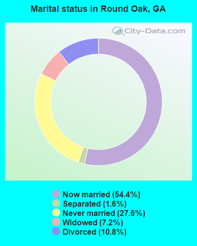
- Never married: 27.6%
- Now married: 54.4%
- Separated: 1.6%
- Widowed: 7.2%
- Divorced: 10.8%
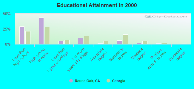
For population 25 years and over in Round Oak:
- High school or higher: 70.9%
- Bachelor's degree or higher: 9.7%
- Graduate or professional degree: 3.4%
- Unemployed: 5.4%
- Mean travel time to work (commute): 31.1 minutes
| Here: | 13.9 |
| Georgia average: | 13.3 |
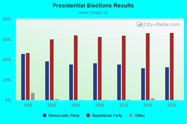
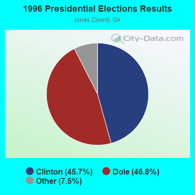
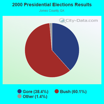


Graphs represent county-level data. Detailed 2008 Election Results
Religion statistics for Round Oak, GA (based on Jones County data)
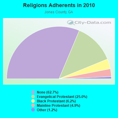
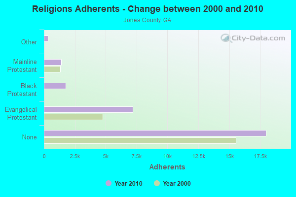
| Religion | Adherents | Congregations |
|---|---|---|
| Evangelical Protestant | 7,173 | 19 |
| Black Protestant | 1,764 | 11 |
| Mainline Protestant | 1,409 | 6 |
| Other | 334 | 2 |
| None | 17,989 | - |
Food Environment Statistics:
| This county: | 0.74 / 10,000 pop. |
| State: | 1.91 / 10,000 pop. |
| This county: | 1.10 / 10,000 pop. |
| Georgia: | 0.86 / 10,000 pop. |
| Here: | 2.58 / 10,000 pop. |
| State: | 5.12 / 10,000 pop. |
| Jones County: | 2.95 / 10,000 pop. |
| Georgia: | 7.41 / 10,000 pop. |
| This county: | 11.5% |
| Georgia: | 10.4% |
| Jones County: | 29.6% |
| Georgia: | 27.8% |
| Jones County: | 12.6% |
| Georgia: | 14.6% |
Strongest AM radio stations in Round Oak:
- WMAC (940 AM; 50 kW; MACON, GA; Owner: CUMULUS LICENSING CORP.)
- WXJO (1120 AM; daytime; 10 kW; GORDON, GA; Owner: ROBERTS COMMUNICATIONS, INC.)
- WGST (640 AM; 50 kW; ATLANTA, GA; Owner: CITICASTERS LICENSES, L.P.)
- WSB (750 AM; 50 kW; ATLANTA, GA; Owner: CXR HOLDINGS, INC.)
- WGUN (1010 AM; 50 kW; ATLANTA, GA; Owner: WGUN, INC.)
- WCNN (680 AM; 50 kW; NORTH ATLANTA, GA; Owner: DICKEY BROADCASTING COMPANY)
- WNNG (1350 AM; 15 kW; WARNER ROBINS, GA; Owner: CHASE BROADCASTING, INC.)
- WLCG (1280 AM; 5 kW; MACON, GA)
- WBML (900 AM; 2 kW; MACON, GA; Owner: WBML, INC.)
- WQXI (790 AM; 28 kW; ATLANTA, GA; Owner: JEFFERSON-PILOT COMMUNICATIONS COMPANY OF GEORGIA)
- WAOK (1380 AM; 50 kW; ATLANTA, GA; Owner: INFINITY BROADCASTING OPERATIONS, INC.)
- WMLB (1160 AM; 50 kW; EAST POINT, GA; Owner: ATLANTA AREA BROADCASTING, INC.)
- WFTD (1080 AM; daytime; 50 kW; MARIETTA, GA; Owner: PRIETO ENTERPRISES, INC.)
Strongest FM radio stations in Round Oak:
- WYNF (96.5 FM; GRAY, GA; Owner: CLEVELAND RADIO LICENSES, LLC)
- WQMJ (100.1 FM; FORSYTH, GA; Owner: ROBERTS COMMUNICATIONS, INC.)
- WAYS (105.5 FM; MACON, GA; Owner: CUMULUS LICENSING CORP.)
- WDEN-FM (99.1 FM; MACON, GA; Owner: CUMULUS LICENSING CORP.)
- WFXM (107.1 FM; GORDON, GA; Owner: ROBERTS COMMUNICATIONS, INC.)
- WFSH-FM (104.7 FM; ATHENS, GA; Owner: SOUTH TEXAS BROADCASTING, INC.)
- WPEZ (93.7 FM; JEFFERSONVILLE, GA; Owner: CUMULUS LICENSING CORP.)
- WBKG (88.9 FM; MACON, GA; Owner: AMERICAN FAMILY ASSOCIATION)
- WQBZ (106.3 FM; FORT VALLEY, GA; Owner: CLEVELAND RADIO LICENSES, LLC)
- WMGZ (97.7 FM; EATONTON, GA; Owner: MIDDLE GEORGIA COMMUNICATIONS, INC.)
- WPMA (102.7 FM; BUCKHEAD, GA; Owner: BARINOWSKI INVESTMENT COMPANY, L.P.)
- WMKS (92.3 FM; MACON, GA; Owner: CUMULUS LICENSING CORP.)
- WLRR (100.7 FM; MILLEDGEVILLE, GA; Owner: PRESTON W. SMALL)
- WJGA-FM (92.1 FM; JACKSON, GA; Owner: EARNHART BROADCASTING CO., INC.)
- W282AE (104.3 FM; MACON, GA; Owner: BIBLE BROADCASTING NETWORK, INC.)
- WKZR (102.3 FM; MILLEDGEVILLE, GA; Owner: WMVG, INC.)
- W203BH (88.5 FM; MACON, GA; Owner: CALVARY CHAPEL OF TWIN FALLS, INC.)
TV broadcast stations around Round Oak:
- WDMA-LP (Channel 32; MACON, GA; Owner: WORD OF GOD FELLOWSHIP, INC.)
- WPGA-TV (Channel 58; PERRY, GA; Owner: RADIO PERRY, INC.)
- WMGT-TV (Channel 41; MACON, GA; Owner: MORRIS NETWORK, INC.)
- WMAZ-TV (Channel 13; MACON, GA; Owner: GANNETT GEORGIA, L.P.)
- WGXA (Channel 24; MACON, GA; Owner: PIEDMONT TELEVISION OF MACON LICENSE LLC)
- WGNM (Channel 64; MACON, GA; Owner: GOOD NEWS TELEVISION)
- WDCO-TV (Channel 29; COCHRAN, GA; Owner: GEORGIA PUBLIC TELECOMMUNICATIONS COMMISSION)
- National Bridge Inventory (NBI) Statistics
- 1Number of bridges
- 3ft / 1.0mTotal length
- $188,000Total costs
- 1,000Total average daily traffic
- 10Total average daily truck traffic
- 1,500Total future (year 2031) average daily traffic
FCC Registered Antenna Towers:
7- ROSEMARIE NELSON, 0.7 Mi S Of Round Oak On Ga Hwy 11 (Lat: 33.100278 Lon: -83.616944), Type: 61.0, Overall height: 61 m, Registrant: Southern Company Services, Tellic@southernco.Com, , Atlan-ta, Phone: (404) 506-7330
- Richard M Burley, 0.7 Mi S Of Round Oak On Ga Hwy 11 (Lat: 33.100278 Lon: -83.616944), Type: 61.0, Overall height: 61 m, Registrant: Southern Company Services, Rmburley@southernco.Com, , Atlan-ta, Phone: (404) 506-3808
- Jimmy R Williams, 0.7 Mi S Of Round Oak On Ga Hwy 11 (Lat: 33.100250 Lon: -83.616944), Type: 61.0, Overall height: 61 m, Registrant: Southern Company Services, Rmburley@southernco.Com, , Atlan-ta, Phone: (404) 506-3808
- Jimmy R Williams, 0.7 Mi S Of Round Oak On Ga Hwy 11 (Lat: 33.100250 Lon: -83.616944), Type: 61.0, Overall height: 61 m, Registrant: Southern Company Services, Rmburley@southernco.Com, , Atlan-ta, Phone: (404) 506-3808
- Larry F Butts, 0.7 Mi S Of Round Oak On Ga Hwy 11 (Lat: 33.100250 Lon: -83.616944), Type: 61.0, Structure height: 13169 m, Overall height: 61 m, Registrant: Southern Company Services, Mvwright@southernco.Com, , Atlan-ta, Phone: (404) 506-3846
- 0.7 Mi S Of Round Oak On Ga Hwy. 11 (Lat: 33.100278 Lon: -83.616944), Type: 67.7, Overall height: 61 m, Registrant: Georgia Power Company, Rich.M.Burley@gpc.Com, , BIN 10030 Atlan-ta, Phone: (404) 526-3808
- 0.7 Mi S Of Round Oak On Ga Hwy 11 (Lat: 33.100278 Lon: -83.616944), Type: 61.0, Overall height: 61 m, Registrant: Georgia Power Company, Rich.M.Burley@gpc.Com, , BIN 10030 Atlan-ta, Phone: (404) 526-3808
FCC Registered Broadcast Land Mobile Towers:
2- 112 Juliette Rd (Lat: 33.119444 Lon: -83.625667), Type: Gtower, Structure height: 30.5 m, Overall height: 33.5 m, Call Sign: KIL699,
Assigned Frequencies: 158.925 MHz, 154.280 MHz, 151.145 MHz, 159.277 MHz, 159.255 MHz, 151.100 MHz, 151.115 MHz, 151.280 MHz, 159.285 MHz, 159.360 MHz, 159.390 MHz, Grant Date: 04/28/2023, Expiration Date: 05/27/2033, Registrant: Gta Gfc Jones Unit, 5645 Riggins Mill Rd, Dry Branch, GA 31020, Phone: (478) 751-3494, Email:
- Ga Hwy 11 .7 Mi S (Lat: 33.100139 Lon: -83.616833), Call Sign: KVO484,
Assigned Frequencies: 451.050 MHz, 451.050 MHz, 451.475 MHz, 451.475 MHz, Grant Date: 06/26/1999, Expiration Date: 06/26/2004, Cancellation Date: 06/17/2002, Registrant: Mcdermott, Will & Emery, 600 13th Street, Nw, Washington, DC 20005-3096, Phone: (202) 756-8281, Fax: (202) 756-8087, Email:
FCC Registered Microwave Towers:
3- ROUND OAK, 0.7 Mi S Of Round Oak On Ga Hwy 11 (Lat: 33.100111 Lon: -83.616833), Type: Ltower, Structure height: 61 m, Call Sign: WPNA247,
Assigned Frequencies: 6715.00 MHz, 6735.00 MHz, 11095.0 MHz, 11095.0 MHz, 11095.0 MHz, 11095.0 MHz, 11095.0 MHz, 11095.0 MHz, 11095.0 MHz, 11095.0 MHz... (+18 more), Grant Date: 12/04/2021, Expiration Date: 12/04/2031, Registrant: Southern Company Services, 600 N. 18th St / Bin 5n-5409, Birmingham, AL 35203, Phone: (205) 257-7600, Fax: (205) 257-2134, Email:
- ROUND OAK, 0.25 Mile South Of (Lat: 33.105389 Lon: -83.612944), Overall height: 55.8 m, Call Sign: KJG92,
Assigned Frequencies: 3730.00 MHz, Grant Date: 06/02/1994, Expiration Date: 02/01/2000, Cancellation Date: 01/27/1998, Registrant: At&t Communications Of The Southern States, 1200 Peachtree Street Ne, Atlanta, GA 30309
- STATION, Hwy 11 0.7 Mi S Of (Lat: 33.100111 Lon: -83.616833), Overall height: 61 m, Call Sign: KOY29,
Assigned Frequencies: 1885.00 MHz, 6795.00 MHz, 6755.00 MHz, Grant Date: 04/09/1996, Expiration Date: 04/09/2001, Cancellation Date: 06/16/1997, Phone: (404) 526-3808
FCC Registered Amateur Radio Licenses:
2- Call Sign: KM4DEL, Licensee ID: L01881707, Grant Date: 07/21/2014, Expiration Date: 07/21/2024, Certifier: Thomas A White, Registrant: Thomas A White, 2131 Monticello Hwy, Round Oak, GA 31038
- Call Sign: KM4DEM, Licensee ID: L01881708, Grant Date: 07/21/2014, Expiration Date: 07/21/2024, Certifier: Andrew R White, Registrant: Andrew R White, 2131 Monticello Hwy, Round Oak, GA 31038
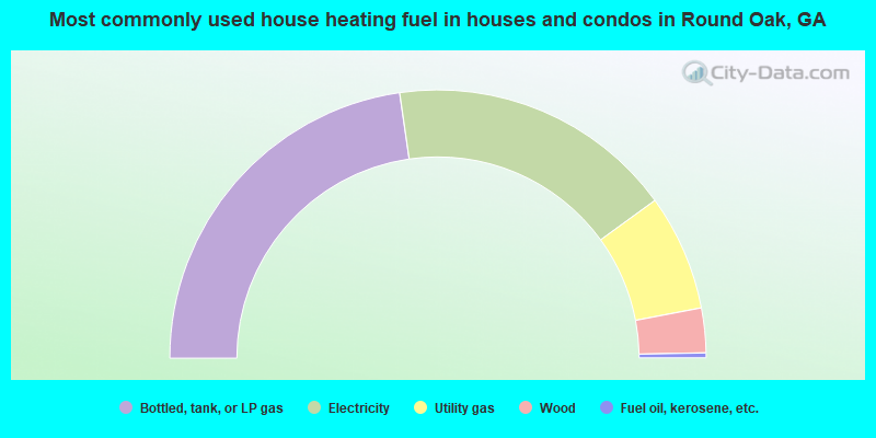
- 45.5%Bottled, tank, or LP gas
- 34.6%Electricity
- 14.0%Utility gas
- 5.4%Wood
- 0.6%Fuel oil, kerosene, etc.
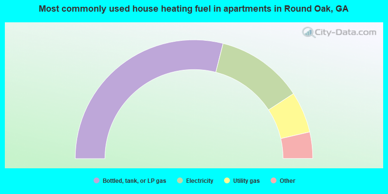
- 57.9%Bottled, tank, or LP gas
- 23.7%Electricity
- 11.2%Utility gas
- 2.6%Wood
- 2.6%Other fuel
- 2.0%Fuel oil, kerosene, etc.
Round Oak compared to Georgia state average:
- Median house value below state average.
- Unemployed percentage below state average.
- Hispanic race population percentage significantly below state average.
- Median age below state average.
- Foreign-born population percentage significantly below state average.
- Renting percentage below state average.
- Length of stay since moving in significantly above state average.
- Number of rooms per house significantly below state average.
- House age significantly below state average.
- Percentage of population with a bachelor's degree or higher significantly below state average.