Royalton, Kentucky
Submit your own pictures of this place and show them to the world
- OSM Map
- General Map
- Google Map
- MSN Map

| Males: 1,126 | |
| Females: 1,127 |
| Median resident age: | 32.8 years |
| Kentucky median age: | 35.9 years |
Zip code: 41632
| Royalton: | $30,146 |
| KY: | $59,341 |
Estimated per capita income in 2022: $18,105 (it was $9,744 in 2000)
Royalton CCD income, earnings, and wages data
Estimated median house or condo value in 2022: $71,828 (it was $28,500 in 2000)
| Royalton: | $71,828 |
| KY: | $196,300 |
Mean prices in 2022: all housing units: $113,010; detached houses: $159,131; mobile homes: $61,892
Detailed information about poverty and poor residents in Royalton, KY


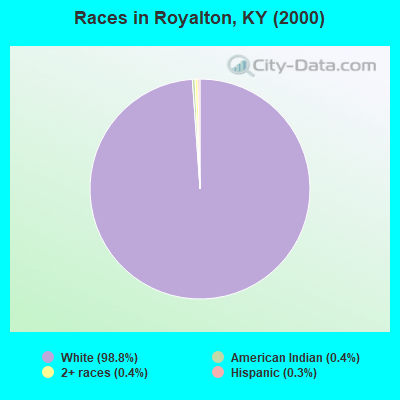
- 2,25498.8%White alone
- 100.4%American Indian alone
- 100.4%Two or more races
- 70.3%Hispanic
Races in Royalton detailed stats: ancestries, foreign born residents, place of birth
 Recent articles from our blog. Our writers, many of them Ph.D. graduates or candidates, create easy-to-read articles on a wide variety of topics.
Current Local Time: EST time zone
Elevation: 890 feet
Land area: 86.9 square miles.
Population density: 26 people per square mile (very low).

| Royalton CCD: | 1.2% ($345) |
| Kentucky: | 0.8% ($610) |
Nearest city with pop. 50,000+: Huntington, WV  (63.7 miles , pop. 51,475).
Nearest city with pop. 200,000+: Fayette, KY (87.6 miles , pop. 260,512).
Nearest city with pop. 1,000,000+: Chicago, IL (385.0 miles , pop. 2,896,016).
Nearest cities:
), ), ), ), ), Latitude: 37.60 N, Longitude: 82.99 W
Area code: 606

| Here: | 9.0% |
| Kentucky: | 3.8% |
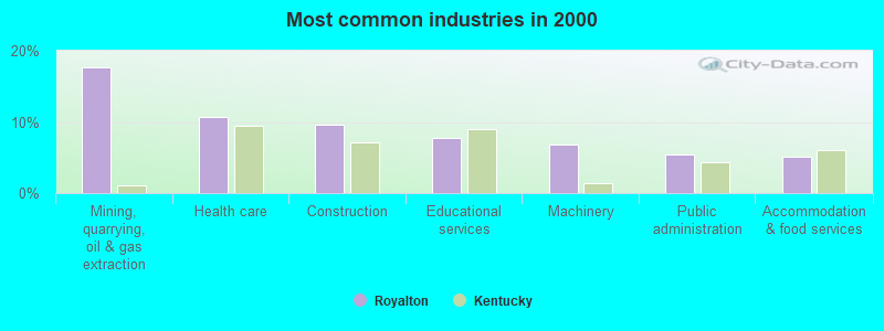
- Mining, quarrying, oil & gas extraction (17.6%)
- Health care (10.7%)
- Construction (9.7%)
- Educational services (7.8%)
- Machinery (6.8%)
- Public administration (5.4%)
- Accommodation & food services (5.1%)
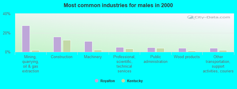
- Mining, quarrying, oil & gas extraction (27.6%)
- Construction (15.7%)
- Machinery (11.0%)
- Professional, scientific, technical services (5.0%)
- Public administration (4.7%)
- Wood products (4.1%)
- Other transportation, support activities, couriers (4.1%)
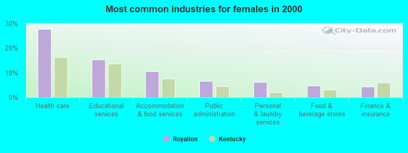
- Health care (27.6%)
- Educational services (15.4%)
- Accommodation & food services (10.5%)
- Public administration (6.6%)
- Personal & laundry services (6.1%)
- Food & beverage stores (4.8%)
- Finance & insurance (4.4%)
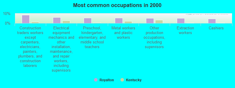
- Construction traders workers except carpenters, electricians, painters, plumbers, and construction laborers (8.5%)
- Electrical equipment mechanics and other installation, maintenance, and repair workers, including supervisors (6.1%)
- Preschool, kindergarten, elementary, and middle school teachers (5.6%)
- Metal workers and plastic workers (5.6%)
- Other production occupations, including supervisors (5.3%)
- Extraction workers (5.3%)
- Cashiers (4.6%)
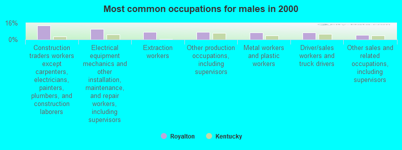
- Construction traders workers except carpenters, electricians, painters, plumbers, and construction laborers (13.8%)
- Electrical equipment mechanics and other installation, maintenance, and repair workers, including supervisors (9.9%)
- Extraction workers (7.5%)
- Other production occupations, including supervisors (7.2%)
- Metal workers and plastic workers (6.9%)
- Driver/sales workers and truck drivers (6.6%)
- Other sales and related occupations, including supervisors (4.4%)
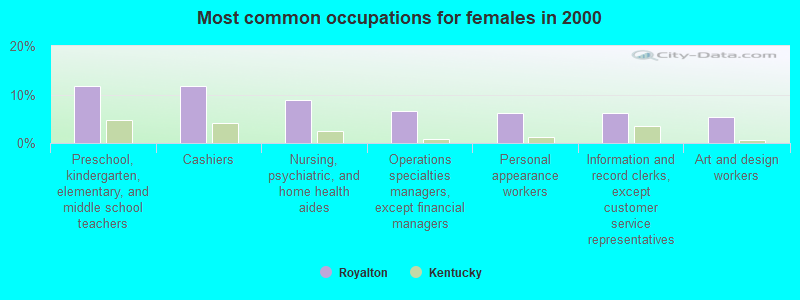
- Preschool, kindergarten, elementary, and middle school teachers (11.8%)
- Cashiers (11.8%)
- Nursing, psychiatric, and home health aides (8.8%)
- Operations specialties managers, except financial managers (6.6%)
- Personal appearance workers (6.1%)
- Information and record clerks, except customer service representatives (6.1%)
- Art and design workers (5.3%)
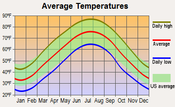
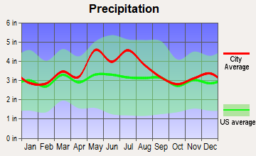
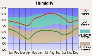
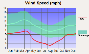
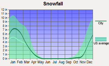
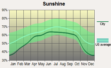
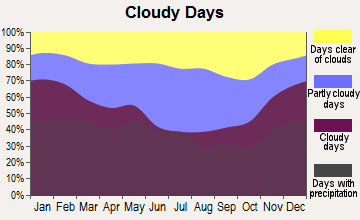
Average climate in Royalton, Kentucky
Based on data reported by over 4,000 weather stations
Tornado activity:
Royalton-area historical tornado activity is significantly below Kentucky state average. It is 65% smaller than the overall U.S. average.
On 6/9/1961, a category F3 (max. wind speeds 158-206 mph) tornado 43.2 miles away from the Royalton place center killed one person and injured 63 people and caused between $500,000 and $5,000,000 in damages.
On 5/18/1995, a category F2 (max. wind speeds 113-157 mph) tornado 17.5 miles away from the place center caused between $50,000 and $500,000 in damages.
Earthquake activity:
Royalton-area historical earthquake activity is significantly above Kentucky state average. It is 33% greater than the overall U.S. average.On 7/27/1980 at 18:52:21, a magnitude 5.2 (5.1 MB, 4.7 MS, 5.0 UK, 5.2 UK, Class: Moderate, Intensity: VI - VII) earthquake occurred 66.9 miles away from the city center
On 8/9/2020 at 12:07:37, a magnitude 5.1 (5.1 MW, Depth: 4.7 mi) earthquake occurred 130.3 miles away from the city center
On 8/23/2011 at 17:51:04, a magnitude 5.8 (5.8 MW, Depth: 3.7 mi) earthquake occurred 276.9 miles away from Royalton center
On 9/7/1988 at 02:28:09, a magnitude 4.6 (4.5 MB, 4.6 LG, Class: Light, Intensity: IV - V) earthquake occurred 61.4 miles away from Royalton center
On 11/30/1973 at 07:48:41, a magnitude 4.7 (4.7 MB, 4.6 ML) earthquake occurred 135.9 miles away from Royalton center
On 4/18/2008 at 09:36:59, a magnitude 5.4 (5.1 MB, 4.8 MS, 5.4 MW, 5.2 MW) earthquake occurred 273.3 miles away from the city center
Magnitude types: regional Lg-wave magnitude (LG), body-wave magnitude (MB), local magnitude (ML), surface-wave magnitude (MS), moment magnitude (MW)
Natural disasters:
The number of natural disasters in Magoffin County (38) is a lot greater than the US average (15).Major Disasters (Presidential) Declared: 30
Emergencies Declared: 3
Causes of natural disasters: Floods: 27, Storms: 25, Tornadoes: 13, Mudslides: 11, Landslides: 7, Winter Storms: 7, Winds: 4, Fires: 2, Snowstorms: 2, Blizzard: 1, Freeze: 1, Hurricane: 1, Snow: 1, Snowfall: 1, Other: 1 (Note: some incidents may be assigned to more than one category).
Colleges/universities with over 2000 students nearest to Royalton:
- Big Sandy Community and Technical College (about 13 miles; Prestonsburg, KY; Full-time enrollment: 2,660)
- Hazard Community and Technical College (about 28 miles; Hazard, KY; FT enrollment: 2,087)
- Southeast Kentucky Community and Technical College (about 44 miles; Cumberland, KY; FT enrollment: 2,196)
- Morehead State University (about 48 miles; Morehead, KY; FT enrollment: 7,523)
- Ashland Community and Technical College (about 63 miles; Ashland, KY; FT enrollment: 2,482)
- Marshall University (about 65 miles; Huntington, WV; FT enrollment: 11,450)
- Eastern Kentucky University (about 73 miles; Richmond, KY; FT enrollment: 13,525)
Points of interest:
Churches in Royalton include: Gun Creek Church (A), Little Martha Church (B), Big Lick Church (C), Pentecostal Church of God (D), Little Rachel Church (E), Brushy Fork Church (F), Little Rachael United Baptist Church (G), Swampton Church (H), Waldo Wayside Church (I). Display/hide their locations on the map
Cemeteries: Howard Cemetery (1), Gullett Cemetery (2), Howard-Shepard Cemetery (3), Hale Cemetery (4), Boone Howard Cemetery (5), Brown Cemetery (6), Conley Cemetery (7). Display/hide their locations on the map
Streams, rivers, and creeks: Allen Wireman Branch (A), Alum Cave Creek (B), Alum Rock Branch (C), Ashlog Branch (D), Barb Fork (E), Becky Branch (F), Beetree Branch (G), Big Half Mountain Creek (H), Bobs Branch (I). Display/hide their locations on the map
| This place: | 2.5 people |
| Kentucky: | 2.5 people |
| This place: | 70.3% |
| Whole state: | 66.9% |
| This place: | 4.4% |
| Whole state: | 6.4% |
No gay or lesbian households reported
| This place: | 39.0% |
| Whole state: | 15.8% |
| This place: | 21.0% |
| Whole state: | 6.6% |
For population 15 years and over in Royalton:
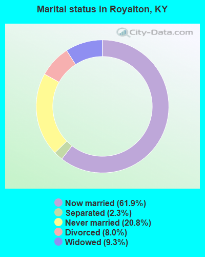
- Never married: 20.8%
- Now married: 61.9%
- Separated: 2.3%
- Widowed: 9.3%
- Divorced: 8.0%
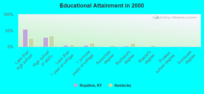
For population 25 years and over in Royalton:
- High school or higher: 45.8%
- Bachelor's degree or higher: 5.4%
- Graduate or professional degree: 2.0%
- Unemployed: 12.5%
- Mean travel time to work (commute): 47.1 minutes
| Here: | 20.3 |
| Kentucky average: | 13.8 |
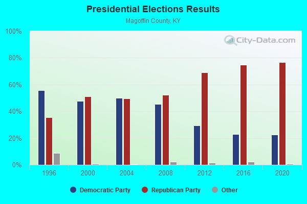
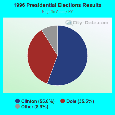
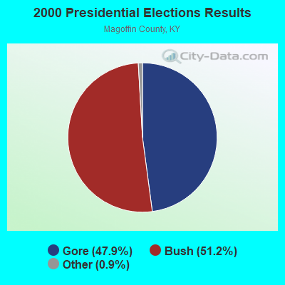
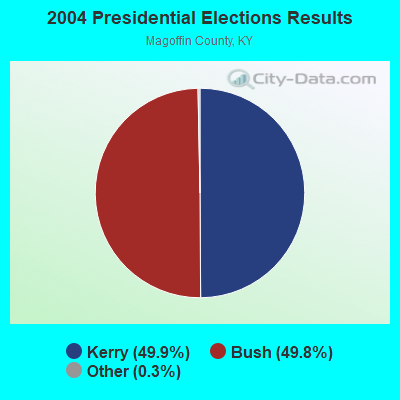
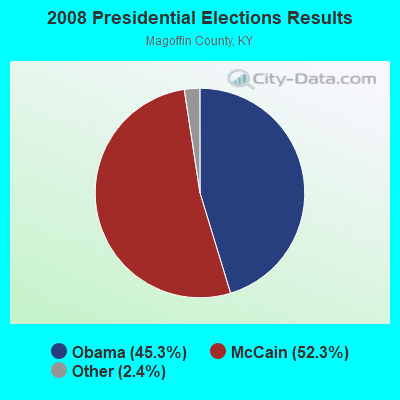
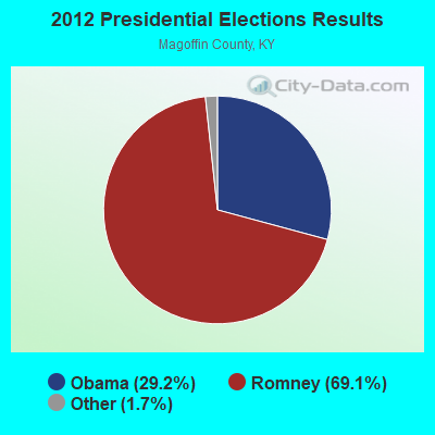
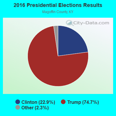
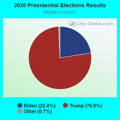
Graphs represent county-level data. Detailed 2008 Election Results
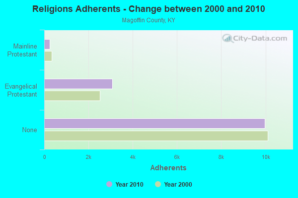
Religion statistics for Royalton, KY (based on Magoffin County data)
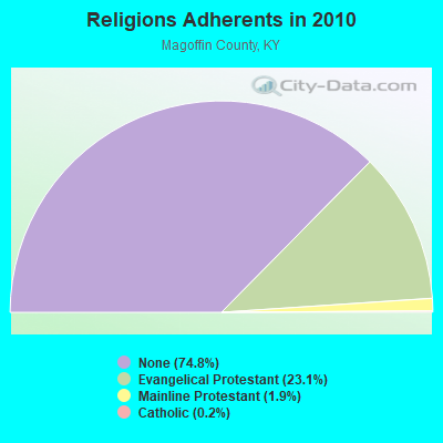
| Religion | Adherents | Congregations |
|---|---|---|
| Evangelical Protestant | 3,083 | 21 |
| Mainline Protestant | 249 | 1 |
| Catholic | 31 | 1 |
| None | 9,970 | - |
Food Environment Statistics:
| Magoffin County: | 2.27 / 10,000 pop. |
| State: | 2.19 / 10,000 pop. |
| Magoffin County: | 0.76 / 10,000 pop. |
| State: | 0.74 / 10,000 pop. |
| This county: | 5.30 / 10,000 pop. |
| State: | 4.36 / 10,000 pop. |
| This county: | 3.79 / 10,000 pop. |
| State: | 5.74 / 10,000 pop. |
| Magoffin County: | 11.3% |
| Kentucky: | 11.0% |
| Magoffin County: | 30.1% |
| Kentucky: | 30.0% |
| Here: | 24.4% |
| Kentucky: | 15.9% |
Strongest AM radio stations in Royalton:
- WPRT (960 AM; 5 kW; PRESTONSBURG, KY; Owner: EAST KENTUCKY RADIO NETWORK, INC.)
- WKYH (600 AM; 5 kW; PAINTSVILLE, KY; Owner: HIGHLANDS BROADCASTING CORPORATION)
- WDOC (1310 AM; 5 kW; PRESTONSBURG, KY)
- WEKG (810 AM; daytime; 5 kW; JACKSON, KY; Owner: INTERMOUNTAIN B/CING CO., INC.)
- WMTC (730 AM; 5 kW; VANCLEVE, KY; Owner: THE KENTUCKY MOUNTAIN HOLINESS ASSN.)
- WLSI (900 AM; 5 kW; PIKEVILLE, KY; Owner: EAST KENTUCKY BROADCASTING CORPORATION)
- WRLV (1140 AM; daytime; 1 kW; SALYERSVILLE, KY; Owner: WALLINGFORD BROADCASTING COMPANY, INC)
- WKIC (1390 AM; 5 kW; HAZARD, KY)
- WTVN (610 AM; 50 kW; COLUMBUS, OH; Owner: CITICASTERS LICENSES, L.P.)
- WKVL (850 AM; daytime; 50 kW; KNOXVILLE, TN; Owner: HORNE RADIO, LLC)
- WTCW (920 AM; 4 kW; WHITESBURG, KY; Owner: T.C.W. BROADCASTING , INC.)
- WEZC (1480 AM; daytime; 5 kW; NEON, KY; Owner: JESUS COMMUNICATION ILNC.)
- WLW (700 AM; 50 kW; CINCINNATI, OH; Owner: JACOR BROADCASTING CORPORATION)
Strongest FM radio stations in Royalton:
- WQHY (95.5 FM; PRESTONSBURG, KY; Owner: WDOC, INC.)
- WKLW-FM (94.7 FM; PAINTSVILLE, KY; Owner: B & G BROADCASTING, INC.)
- WSGS (101.1 FM; HAZARD, KY; Owner: MOUNTAIN BROADCASTING SERVICE, INC.)
- WZQQ (97.9 FM; HYDEN, KY; Owner: LESLIE COUNTY BROADCASTING, INC.)
- WJMD (104.7 FM; HAZARD, KY; Owner: HAZARD BROADCASTING SERVICES)
- WSIP-FM (98.9 FM; PAINTSVILLE, KY; Owner: SIP BROADCASTING, INC.)
- WMDJ-FM (100.1 FM; ALLEN, KY; Owner: FLOYD COUNTY BROADCASTING CO., INC.)
- WRLV-FM (106.5 FM; SALYERSVILLE, KY; Owner: WALLINGFORD BROADCASTING COMPANY, INC.)
- WKCB-FM (107.1 FM; HINDMAN, KY; Owner: HINDMAN BROADCASTING CORPORATION)
- WIFX-FM (94.3 FM; JENKINS, KY; Owner: LETCHER COUNTY BROADCASTING, INC)
- WJSN-FM (106.5 FM; JACKSON, KY; Owner: INTERMOUNTAIN BROADCASTING CO.)
- WXKZ-FM (105.3 FM; PRESTONSBURG, KY; Owner: ADAM GEARHEART D/B/A WXLR-FM)
- WXKQ-FM (103.9 FM; WHITESBURG, KY; Owner: T.C.W. BROADCASTING , INC.)
- WSEH (102.7 FM; CUMBERLAND, KY; Owner: CUMBERLAND CITY BROADCASTING, INC.)
- WMMT (88.7 FM; WHITESBURG, KY; Owner: APPALSHOP, INCORPORATED)
- WXLR (104.9 FM; HAROLD, KY; Owner: ADAM D GEARHEART)
- WEKH (90.9 FM; HAZARD, KY; Owner: EASTERN KENTUCKY UNIVERSITY)
- WDHR (93.1 FM; PIKEVILLE, KY; Owner: EAST KENTUCKY BROADCASTING CORP.)
- WDXC (102.3 FM; POUND, VA; Owner: WDXC RADIO, INC.)
- WAXM (93.5 FM; BIG STONE GAP, VA; Owner: VALLEY BROADCASTING, INC.)
TV broadcast stations around Royalton:
- W26BK (Channel 26; TALBERT, KY; Owner: MS COMMUNICATIONS, LLC)
- W16BI (Channel 16; TALBERT, KY; Owner: MS COMMUNICATIONS, LLC)
- WYMT-TV (Channel 57; HAZARD, KY; Owner: WYMT LICENSEE CORP.)
- WUPX-TV (Channel 67; MOREHEAD, KY; Owner: PAXSON LEXINGTON LICENSE, INC.)
- W24BT (Channel 24; TALBERT, KY; Owner: MS COMMUNICATIONS, LLC)
- W64CM (Channel 64; TALBERT, KY; Owner: MS COMMUNICATIONS, LLC)
- W66DA (Channel 66; TALBERT, KY; Owner: MS COMMUNICATIONS, LLC)
- WLJC-TV (Channel 65; BEATTYVILLE, KY; Owner: HOUR OF HARVEST, INC.)
- WKHA (Channel 35; HAZARD, KY; Owner: KENTUCKY AUTHORITY FOR EDUCATIONAL TV)
- W31BU (Channel 31; TALBERT, KY; Owner: MS COMMUNICATIONS, LLC)
- W53BQ (Channel 53; TALBERT, KY; Owner: MS COMMUNICATIONS, LLC)
- W69ED (Channel 69; TALBERT, KY; Owner: MS COMMUNICATIONS, LLC)
- W54CI (Channel 54; TALBERT, KY; Owner: MS COMMUNICATIONS, LLC)
FCC Registered Antenna Towers:
4- Gerald F Robinette, 2.4 Km (1.5 Mi) Northwest Of (Lat: 37.690778 Lon: -83.041083), Type: 94.5, Structure height: 21153 m, Overall height: 91.4 m, Registrant: Lukas, Nace, Gutierrez & Sachs, LLP, Pgist@fcclaw.Com, Suite 1200, Mclea-n, Phone: (703) 584-8665
- Gerald F Robinette, 2.4 Km (1.5 Mi) Northwest Of (Lat: 37.690778 Lon: -83.041083), Type: 94.5, Structure height: 21153 m, Overall height: 91.4 m, Registrant: Lukas, Nace, Gutierrez & Sachs, LLP, Pgist@fcclaw.Com, Suite 1200, Mclea-n, Phone: (703) 584-8665
- Gerald F Robinette, 2.4 Km (1.5 Mi) Northwest Of (Lat: 37.690778 Lon: -83.041083), Type: 94.5, Structure height: 21153 m, Overall height: 91.4 m, Registrant: Lukas, Nace, Gutierrez & Sachs, LLP, Pgist@fcclaw.Com, Suite 1200, Mclea-n, Phone: (703) 584-8665
- Michael L Johnson, 2.4 Km (1.5 Mi) Northwest Of (Lat: 37.690778 Lon: -83.041083), Type: 94.5, Structure height: 21153 m, Overall height: 91.4 m, Registrant: East Kentucky Network, LLC D/B/A Appalachian Wireless, Compliance@ekn.Com, , Ivel, Phone: (606) 477-2355

- 37.7%Electricity
- 33.8%Utility gas
- 13.4%Bottled, tank, or LP gas
- 6.1%Fuel oil, kerosene, etc.
- 5.5%Wood
- 3.5%Coal or coke
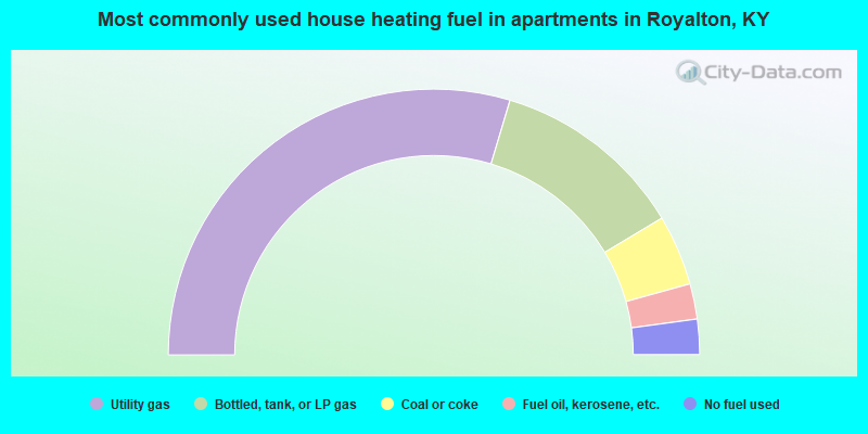
- 59.3%Utility gas
- 23.6%Bottled, tank, or LP gas
- 8.6%Coal or coke
- 4.3%Fuel oil, kerosene, etc.
- 4.3%No fuel used
Royalton compared to Kentucky state average:
- Median household income below state average.
- Median house value significantly below state average.
- Black race population percentage significantly below state average.
- Hispanic race population percentage significantly below state average.
- Median age significantly below state average.
- Foreign-born population percentage significantly below state average.
- Renting percentage below state average.
- Length of stay since moving in significantly above state average.
- Number of rooms per house significantly below state average.
- House age significantly below state average.
- Percentage of population with a bachelor's degree or higher significantly below state average.