Salem, Alabama
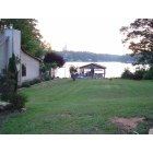
Submit your own pictures of this place and show them to the world
- OSM Map
- General Map
- Google Map
- MSN Map

| Males: 2,016 | |
| Females: 2,011 |
| Median resident age: | 35.8 years |
| Alabama median age: | 35.8 years |
Zip code: 35647
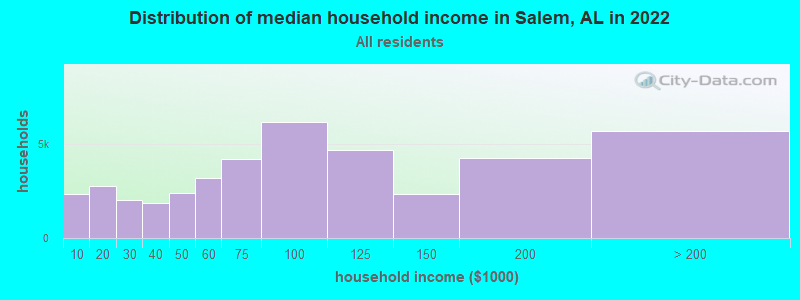
| Salem: | $88,442 |
| AL: | $59,674 |
Estimated per capita income in 2022: $38,344 (it was $17,154 in 2000)
Salem CCD income, earnings, and wages data
Estimated median house or condo value in 2022: $255,508 (it was $72,400 in 2000)
| Salem: | $255,508 |
| AL: | $200,900 |
Detailed information about poverty and poor residents in Salem, AL


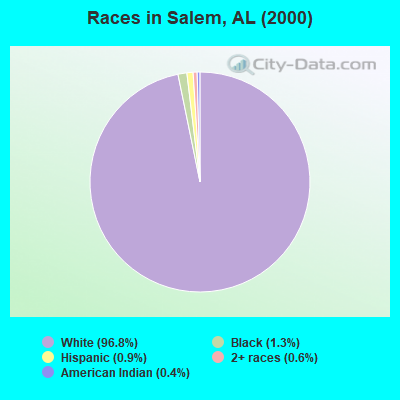
- 3,47796.8%White alone
- 451.3%Black alone
- 330.9%Hispanic
- 220.6%Two or more races
- 130.4%American Indian alone
- 20.06%Asian alone
- 10.03%Native Hawaiian and Other
Pacific Islander alone
According to our research of Alabama and other state lists, there were 29 registered sex offenders living in Salem, Alabama as of April 23, 2024.
The ratio of all residents to sex offenders in Salem is 139 to 1.
 Recent articles from our blog. Our writers, many of them Ph.D. graduates or candidates, create easy-to-read articles on a wide variety of topics.
Current Local Time: CST time zone
Land area: 93.2 square miles.
Population density: 43 people per square mile (very low).
| Salem CCD: | 0.3% ($199) |
| Alabama: | 0.4% ($289) |
Nearest city with pop. 50,000+: Decatur, AL  (25.6 miles , pop. 53,929).
Nearest city with pop. 200,000+: Nashville-Davidson, TN (87.7 miles , pop. 545,524).
Nearest city with pop. 1,000,000+: Chicago, IL (479.1 miles , pop. 2,896,016).
Nearest cities:
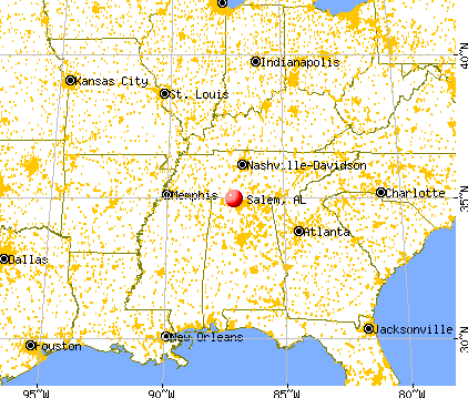
), ), ), ), Latitude: 34.93 N, Longitude: 87.15 W

Salem tourist attractions:
| Here: | 2.2% |
| Alabama: | 2.6% |
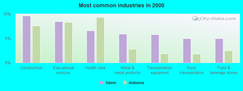
- Construction (9.6%)
- Educational services (8.4%)
- Health care (6.6%)
- Metal & metal products (5.9%)
- Transportation equipment (5.8%)
- Truck transportation (5.0%)
- Food & beverage stores (5.0%)
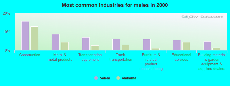
- Construction (15.7%)
- Metal & metal products (8.7%)
- Transportation equipment (7.0%)
- Truck transportation (6.2%)
- Furniture & related product manufacturing (6.0%)
- Educational services (5.6%)
- Building material & garden equipment & supplies dealers (4.8%)
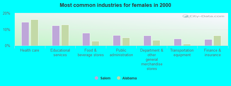
- Health care (14.6%)
- Educational services (12.3%)
- Food & beverage stores (7.7%)
- Public administration (6.4%)
- Department & other general merchandise stores (6.2%)
- Transportation equipment (4.2%)
- Finance & insurance (3.9%)
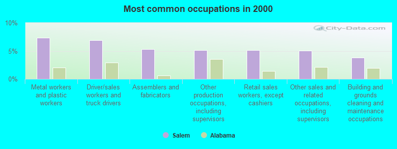
- Metal workers and plastic workers (7.3%)
- Driver/sales workers and truck drivers (6.9%)
- Assemblers and fabricators (5.3%)
- Other production occupations, including supervisors (5.2%)
- Retail sales workers, except cashiers (5.1%)
- Other sales and related occupations, including supervisors (5.0%)
- Building and grounds cleaning and maintenance occupations (3.8%)
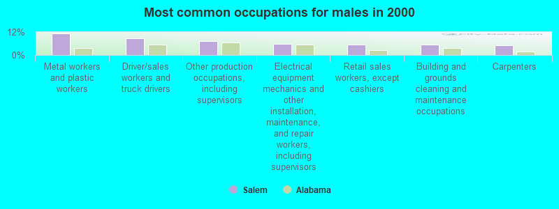
- Metal workers and plastic workers (11.4%)
- Driver/sales workers and truck drivers (8.9%)
- Other production occupations, including supervisors (7.2%)
- Electrical equipment mechanics and other installation, maintenance, and repair workers, including supervisors (5.9%)
- Retail sales workers, except cashiers (5.5%)
- Building and grounds cleaning and maintenance occupations (5.5%)
- Carpenters (4.9%)
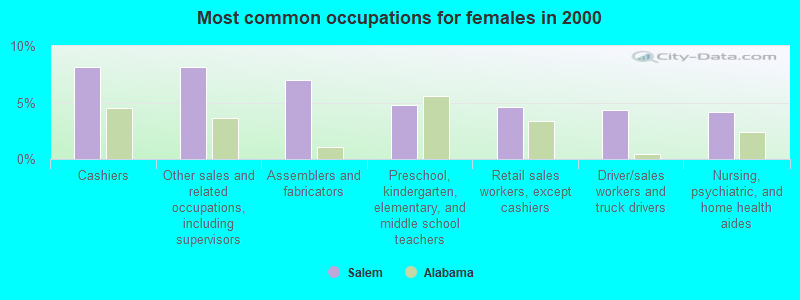
- Cashiers (8.2%)
- Other sales and related occupations, including supervisors (8.2%)
- Assemblers and fabricators (7.0%)
- Preschool, kindergarten, elementary, and middle school teachers (4.8%)
- Retail sales workers, except cashiers (4.6%)
- Driver/sales workers and truck drivers (4.3%)
- Nursing, psychiatric, and home health aides (4.2%)
Average climate in Salem, Alabama
Based on data reported by over 4,000 weather stations


(lower is better)
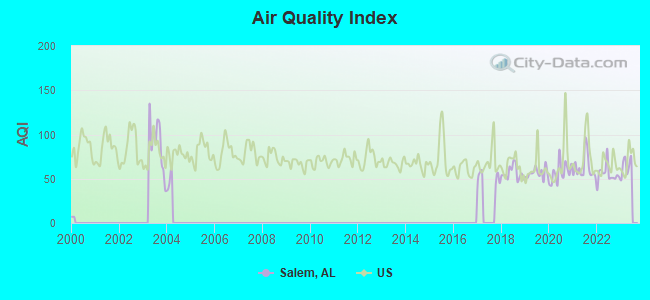
Air Quality Index (AQI) level in 2022 was 55.1. This is better than average.
| City: | 55.1 |
| U.S.: | 72.6 |
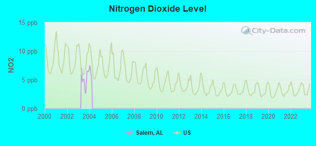
Nitrogen Dioxide (NO2) [ppb] level in 2003 was 5.26. This is about average. Closest monitor was 11.8 miles away from the city center.
| City: | 5.26 |
| U.S.: | 5.11 |
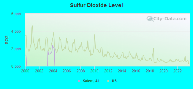
Sulfur Dioxide (SO2) [ppb] level in 2003 was 1.61. This is about average. Closest monitor was 11.8 miles away from the city center.
| City: | 1.61 |
| U.S.: | 1.51 |
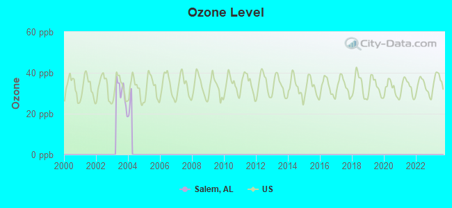
Ozone [ppb] level in 2003 was 30.3. This is about average. Closest monitor was 17.9 miles away from the city center.
| City: | 30.3 |
| U.S.: | 33.3 |
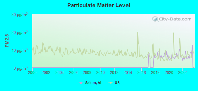
Particulate Matter (PM2.5) [µg/m3] level in 2022 was 5.72. This is significantly better than average. Closest monitor was 20.4 miles away from the city center.
| City: | 5.72 |
| U.S.: | 8.11 |
Tornado activity:
Salem-area historical tornado activity is slightly above Alabama state average. It is 127% greater than the overall U.S. average.
On 4/3/1974, a category F5 (max. wind speeds 261-318 mph) tornado 16.6 miles away from the Salem place center killed 16 people and injured 190 people.
On 4/3/1974, a category F5 tornado 26.2 miles away from the place center killed 28 people and injured 267 people.
Earthquake activity:
Salem-area historical earthquake activity is significantly above Alabama state average. It is 196% greater than the overall U.S. average.On 4/29/2003 at 08:59:39, a magnitude 4.9 (4.4 MB, 4.6 MW, 4.9 LG, Class: Light, Intensity: IV - V) earthquake occurred 91.3 miles away from Salem center
On 1/18/1999 at 07:00:53, a magnitude 4.8 (4.8 MB, 4.0 LG, Depth: 0.6 mi) earthquake occurred 105.4 miles away from the city center
On 4/18/2008 at 09:36:59, a magnitude 5.4 (5.1 MB, 4.8 MS, 5.4 MW, 5.2 MW, Class: Moderate, Intensity: VI - VII) earthquake occurred 247.3 miles away from Salem center
On 4/29/2003 at 08:59:39, a magnitude 4.6 (4.6 MW, Depth: 12.3 mi) earthquake occurred 91.2 miles away from the city center
On 3/25/1976 at 00:41:20, a magnitude 5.0 (4.9 MB, 5.0 LG) earthquake occurred 186.2 miles away from Salem center
On 5/4/1991 at 01:18:54, a magnitude 5.0 (4.4 MB, 4.6 LG, 5.0 LG, Depth: 3.1 mi) earthquake occurred 188.2 miles away from Salem center
Magnitude types: regional Lg-wave magnitude (LG), body-wave magnitude (MB), surface-wave magnitude (MS), moment magnitude (MW)
Natural disasters:
The number of natural disasters in Limestone County (18) is near the US average (15).Major Disasters (Presidential) Declared: 11
Emergencies Declared: 5
Causes of natural disasters: Floods: 8, Storms: 8, Tornadoes: 7, Hurricanes: 3, Winds: 3, Freezes: 2, Winter Storms: 2, Drought: 1, Ice Storm: 1, Snowfall: 1, Other: 1 (Note: some incidents may be assigned to more than one category).
Hospitals and medical centers near Salem:
- LIMESTONE HEALTH FACILITY (Nursing Home, about 13 miles away; ATHENS, AL)
- LIMESTONE COUNTY DIALYSIS (Dialysis Facility, about 13 miles away; ATHENS, AL)
- ATHENS-LIMESTONE HOSPITAL Acute Care Hospitals (about 13 miles away; ATHENS, AL)
- ATHENS REHABILITATION CENTER AND SENIOR CARE (Nursing Home, about 13 miles away; ATHENS, AL)
- HOSPICE OF LIMESTONE COUNTY (Hospital, about 14 miles away; ATHENS, AL)
- ATHENS-LIMESTONE HOMECARE (Home Health Center, about 15 miles away; ATHENS, AL)
Colleges/universities with over 2000 students nearest to Salem:
- Athens State University (about 14 miles; Athens, AL; Full-time enrollment: 2,771)
- John C Calhoun State Community College (about 22 miles; Tanner, AL; FT enrollment: 7,911)
- University of North Alabama (about 32 miles; Florence, AL; FT enrollment: 5,886)
- University of Alabama in Huntsville (about 33 miles; Huntsville, AL; FT enrollment: 6,006)
- Northwest-Shoals Community College (about 33 miles; Muscle Shoals, AL; FT enrollment: 2,702)
- Alabama A & M University (about 35 miles; Normal, AL; FT enrollment: 4,524)
- Columbia State Community College (about 48 miles; Columbia, TN; FT enrollment: 3,383)
Points of interest:
Notable locations in Salem: Elk River Fish Hatchery (A), Maple Store (B), Pleasant Grove Volunteer Fire Department (C), West Limestone Volunteer Fire Department (D), Good Springs Volunteer Fire Department (E). Display/hide their locations on the map
Churches in Salem include: Pleasant Valley Church of Christ (A), Holbert Springs Primitive Baptist Church (B), Gaston Church (C), Carriger Church of Christ (D), Lentzville United Methodist Church (E), Union Hill Church (F), Salem Church (G), Mount Nebo Church (H), Cairo Church (I). Display/hide their locations on the map
Cemeteries: Smith Cemetery (1), Craig Cemetery (2), Cunningham Cemetery (3), Dupree Cemetery (4), Tedd Cemetery (5), Oak Grove Cemetery (6), Evans Cemetery (7). Display/hide their locations on the map
Reservoirs and swamps: Todd Lake (A), Wheeler Reservoir (B), Maple Swamp (C). Display/hide their locations on the map
Streams, rivers, and creeks: Sugar Creek (A), Stinnet Branch (B), Stewart Branch (C), Shack Branch (D), Scarce Grease Branch (E), Mechanic Branch (F), Shoal Creek (G), McGowan Branch (H), McConnell Branch (I). Display/hide their locations on the map
| This place: | 2.5 people |
| Alabama: | 2.5 people |
| This place: | 75.9% |
| Whole state: | 67.8% |
| This place: | 3.9% |
| Whole state: | 4.7% |
Likely homosexual households (counted as self-reported same-sex unmarried-partner households)
- Lesbian couples: 0.2% of all households
- Gay men: 0.1% of all households
| This place: | 9.8% |
| Whole state: | 16.1% |
| This place: | 3.5% |
| Whole state: | 7.3% |
For population 15 years and over in Salem:
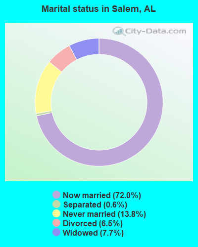
- Never married: 13.8%
- Now married: 72.0%
- Separated: 0.6%
- Widowed: 7.7%
- Divorced: 6.5%
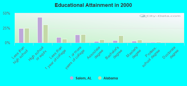
For population 25 years and over in Salem:
- High school or higher: 75.5%
- Bachelor's degree or higher: 7.5%
- Graduate or professional degree: 3.7%
- Unemployed: 4.2%
- Mean travel time to work (commute): 34.1 minutes
| Here: | 11.1 |
| Alabama average: | 13.2 |
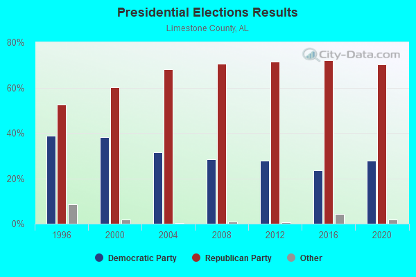
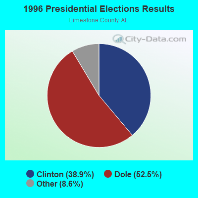
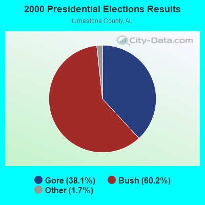
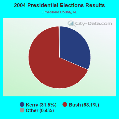


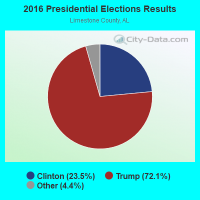
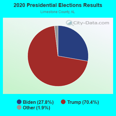
Graphs represent county-level data. Detailed 2008 Election Results
Religion statistics for Salem, AL (based on Limestone County data)
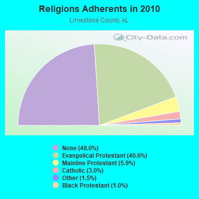
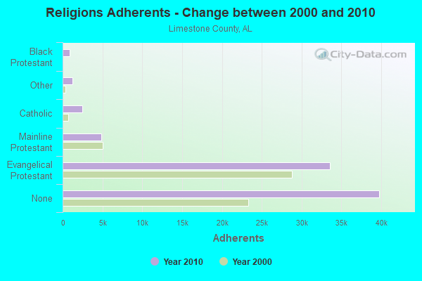
| Religion | Adherents | Congregations |
|---|---|---|
| Evangelical Protestant | 33,582 | 122 |
| Mainline Protestant | 4,899 | 25 |
| Catholic | 2,462 | 1 |
| Other | 1,209 | 4 |
| Black Protestant | 866 | 14 |
| None | 39,764 | - |
Food Environment Statistics:
| Limestone County: | 1.35 / 10,000 pop. |
| Alabama: | 1.89 / 10,000 pop. |
| This county: | 0.14 / 10,000 pop. |
| Alabama: | 0.20 / 10,000 pop. |
| Limestone County: | 0.68 / 10,000 pop. |
| Alabama: | 0.65 / 10,000 pop. |
| Limestone County: | 6.09 / 10,000 pop. |
| Alabama: | 6.32 / 10,000 pop. |
| This county: | 4.47 / 10,000 pop. |
| Alabama: | 5.75 / 10,000 pop. |
| This county: | 9.8% |
| Alabama: | 11.8% |
| This county: | 27.7% |
| State: | 31.7% |
| Limestone County: | 23.1% |
| Alabama: | 13.5% |
10.48% of this county's 2021 resident taxpayers lived in other counties in 2020 ($73,638 average adjusted gross income)
| Here: | 10.48% |
| Alabama average: | 6.87% |
0.06% of residents moved from foreign countries ($538 average AGI)
Limestone County: 0.06% Alabama average: 0.02%
Top counties from which taxpayers relocated into this county between 2020 and 2021:
| from Madison County, AL | |
| from Morgan County, AL | |
| from Lauderdale County, AL |
Strongest AM radio stations in Salem:
- WVNN (770 AM; 10 kW; ATHENS, AL; Owner: ATHENS BROADCASTING COMPANY, INC.)
- WZNN (620 AM; 5 kW; LEXINGTON, AL; Owner: MANUEL HUERTA)
- WLOR (1550 AM; 50 kW; HUNTSVILLE, AL; Owner: BCA RADIO, LLC)
- WKAC (1080 AM; daytime; 5 kW; ATHENS, AL; Owner: LIMESTONE BROADCASTING COMPANY, INC.)
- WBXR (1140 AM; daytime; 15 kW; HAZEL GREEN, AL; Owner: LOW COUNTRY CORPORATION, INC.)
- WSM (650 AM; 50 kW; NASHVILLE, TN; Owner: GAYLORD ENTERTAINMENT COMPANY)
- WDJL (1000 AM; daytime; 10 kW; HUNTSVILLE, AL; Owner: JAMES K. SHARP DBA 5TH AVE BROADCASTING)
- WWAM (820 AM; daytime; 50 kW; JASPER, TN; Owner: SHELTON BROADCASTING SYSTEM)
- WSLV (1110 AM; daytime; 2 kW; ARDMORE, TN; Owner: B & E BROADCASTING, INC.)
- WEUP (1600 AM; 10 kW; HUNTSVILLE, AL; Owner: HUNDLEY BATTS, SR. & VIRGINIA CAPLES)
- WDJC (850 AM; 50 kW; BIRMINGHAM, AL; Owner: KIMTRON, INC.)
- WJOX (690 AM; 50 kW; BIRMINGHAM, AL; Owner: CITADEL BROADCASTING COMPANY)
- WEUV (1700 AM; 10 kW; HUNTSVILLE, AL; Owner: HUNDLEY BATTS, SR & VIRGINIA CAPLES)
Strongest FM radio stations in Salem:
- WAHR (99.1 FM; HUNTSVILLE, AL; Owner: BCA RADIO, LLC)
- WZYP (104.3 FM; ATHENS, AL; Owner: ATHENS BROADCASTING COMPANY, INC.)
- W278AA (103.5 FM; MADISON, AL; Owner: TENNESSEE VALLEY RADIO, INC.)
- WYTK (93.9 FM; ROGERSVILLE, AL; Owner: SHOALS BROADCASTING CORPORATION)
- WEUZ (92.1 FM; MINOR HILL, TN; Owner: BROADCAST ONE, INC.)
- WDRM (102.1 FM; DECATUR, AL; Owner: CAPSTAR TX LIMITED PARTNERSHIP)
- WWXQ (92.5 FM; TRINITY, AL; Owner: CAPSTAR TX LIMITED PARTNERSHIP)
- W289AC (105.7 FM; HUNTSVILLE, AL; Owner: WILLIAM PAXTON ROGERS)
- W238AD (95.5 FM; TRINITY, AL; Owner: PRESS W. PARHAM)
- WLLX (97.5 FM; LAWRENCEBURG, TN; Owner: ROGER WRIGHT DBA PROSPECT COMMUNICATIONS)
- W222AK (92.3 FM; HUNTSVILLE, AL; Owner: PRESS W. PARHAM)
- WAYH (88.1 FM; HARVEST, AL; Owner: WAY-FM MEDIA GROUP, INC.)
- WLAY-FM (100.3 FM; TUSCUMBIA, AL; Owner: CLEAR CHANNEL BROADCASTING LICENSES, INC.)
- WXQW (94.1 FM; MERIDIANVILLE, AL; Owner: CAPSTAR TX LIMITED PARTNERSHIP)
- W293AH (106.5 FM; NORMAL, AL; Owner: CAPSTAR TX LIMITED PARTNERSHIP)
- WYFD (91.7 FM; DECATUR, AL; Owner: BIBLE BROADCASTING NETWORK, INC.)
- WQLT-FM (107.3 FM; FLORENCE, AL; Owner: BIG RIVER BROADCASTING CORPORATION)
- WKSR-FM (98.3 FM; PULASKI, TN; Owner: PULASKI BROADCASTING, INC.)
- WRTT-FM (95.1 FM; HUNTSVILLE, AL; Owner: BCA RADIO, LLC)
- W254AA (98.7 FM; COLBERT HEIGHTS, AL; Owner: WILLIAM P. ROGERS)
TV broadcast stations around Salem:
- WTZT-LP (Channel 11; ATHENS, AL; Owner: WTZT-LP TELEVISION STATION, L.L.C.)
- WZDX (Channel 54; HUNTSVILLE, AL; Owner: HUNTSVILLE TELEVISION ACQUISITION CORP.)
- WHDF (Channel 15; FLORENCE, AL; Owner: VALLEY TELEVISION, LLC)
- WAAY-TV (Channel 31; HUNTSVILLE, AL; Owner: PIEDMONT TELEVISION OF HUNTSVILLE LICENSE LLC)
- WHNT-TV (Channel 19; HUNTSVILLE, AL; Owner: NEW YORK TIMES MANAGEMENT SERVICES)
- National Bridge Inventory (NBI) Statistics
- 25Number of bridges
- 243ft / 74.1mTotal length
- $18,381,000Total costs
- 18,338Total average daily traffic
- 403Total average daily truck traffic
- 25,684Total future (year 2029) average daily traffic
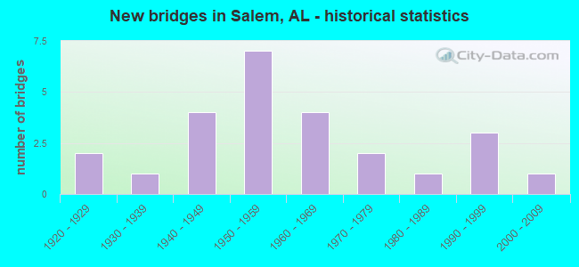
- New bridges - historical statistics
- 21920-1929
- 11930-1939
- 41940-1949
- 71950-1959
- 41960-1969
- 21970-1979
- 11980-1989
- 31990-1999
- 12000-2009
FCC Registered Antenna Towers:
73 (See the full list of FCC Registered Antenna Towers in Salem)FCC Registered Broadcast Land Mobile Towers:
7- REPEATER2, Lee Rd 258 (Lat: 32.642500 Lon: -85.237222), Type: Gtower, Structure height: 111 m, Overall height: 118 m, Call Sign: KCE437,
Assigned Frequencies: 155.145 MHz, Grant Date: 12/29/2021, Expiration Date: 02/10/2032, Registrant: Lee County Emeregency Management, 908 Avenue B, Opelika, AL 36801, Phone: (334) 749-8161, Email:
- Federal 280 Near Salem United Methodist Church (Lat: 32.598472 Lon: -85.240778), Call Sign: KNFL509,
Assigned Frequencies: 153.845 MHz, 155.145 MHz, Grant Date: 02/09/2022, Expiration Date: 04/22/2032, Registrant: Lee County Emergency Management Agency, 908 Avenue B, Opelika, AL 36801, Phone: (334) 749-8161, Email:
- WEST TANK, Easterferry Road (Lat: 34.942611 Lon: -87.084222), Type: Tank, Structure height: 49.2 m, Overall height: 55.8 m, Call Sign: WDD545,
Assigned Frequencies: 453.925 MHz, Grant Date: 02/08/2013, Expiration Date: 03/08/2023, Cancellation Date: 05/13/2023, Registrant: Decatur Electronic Communication, 1222 4th Ave Se, Decatur, AL 35601, Phone: (256) 355-4747, Fax: (256) 355-0670, Email:
- REPEATER2, Lee Rd 258 (Lat: 32.642500 Lon: -85.237222), Type: Gtower, Structure height: 111 m, Overall height: 118 m, Call Sign: WPLS543,
Assigned Frequencies: 155.715 MHz, Grant Date: 11/08/2022, Expiration Date: 01/12/2033, Certifier: Bill Meadows, Registrant: Lee County Emeregency Management, 908 Avenue B, Opelika, AL 36801, Phone: (334) 749-8161, Email:
- Bartletts Ferry Dam (Lat: 32.661806 Lon: -85.091889), Call Sign: KKQ561,
Assigned Frequencies: 451.250 MHz, 456.125 MHz, 456.250 MHz, 456.575 MHz, Grant Date: 08/14/2002, Expiration Date: 08/19/2012, Cancellation Date: 01/18/2012, Registrant: Fish & Richardson P.C., 1425 K Street, N.W., 11th Floor, Washington, DC 20005, Phone: (202) 626-7761, Fax: (202) 783-2331, Email:
- Salem Hill 5 Miles North Of Salem Al (Lat: 32.642639 Lon: -85.237167), Type: Tower, Structure height: 48.8 m, Overall height: 51.2 m, Call Sign: WQEB979,
Assigned Frequencies: 453.400 MHz, 453.400 MHz, Grant Date: 11/24/2015, Expiration Date: 12/27/2025, Certifier: Frederick H Springall, Registrant: Alabama Emergency Management Agency, 5898 County Road 41, Clanton, AL 35046, Phone: (205) 280-2290, Fax: (205) 280-2331, Email:
- 61 Lee Road 335 (Lat: 32.662111 Lon: -85.091611), Type: Pole, Structure height: 39.6 m, Overall height: 45.7 m, Call Sign: WQLX661,
Assigned Frequencies: 151.805 MHz, Grant Date: 06/11/2020, Expiration Date: 05/20/2030, Certifier: Larry F Butts, Registrant: Southern Company Services, 600 N. 18th St / Bin 5n-5409, Birmingham, AL 35203, Phone: (205) 257-7600, Fax: (205) 257-2134, Email:
FCC Registered Microwave Towers:
5- BLEECKER, 111 Lee Road 251 (Lat: 32.587500 Lon: -85.177778), Type: Tower, Structure height: 74.6 m, Overall height: 80.8 m, Call Sign: WPZS441,
Assigned Frequencies: 5974.85 MHz, 6063.80 MHz, 5945.20 MHz, 5974.85 MHz, 6093.45 MHz, 6123.10 MHz, 6004.50 MHz, 6034.15 MHz, 6004.50 MHz, 6063.80 MHz, Grant Date: 03/03/2004, Expiration Date: 03/03/2014, Cancellation Date: 07/30/2004, Certifier: Richard A Craig, Registrant: Verizon Wireless, One Verizon Place (Mc:ga3b1reg), Alpharetta, GA 30004-8511, Phone: (678) 339-4269, Fax: (678) 339-8552, Email:
- BLEEKER, 111 Lee Road 251 (Lat: 32.587639 Lon: -85.177889), Type: Tower, Structure height: 74.7 m, Overall height: 80.8 m, Call Sign: WQER593,
Assigned Frequencies: 6615.00 MHz, Grant Date: 03/29/2006, Expiration Date: 03/29/2016, Cancellation Date: 09/09/2014, Certifier: Richard A Craig, Registrant: Verizon Wireless, 1120 Sanctuary Pkwy, #150 Gasa5reg, Alpharetta, GA 30009-7630, Phone: (770) 797-1070, Fax: (770) 797-1036, Email:
- SALEM ALLTEL, 4426 Lee Road 145 (Lat: 32.597444 Lon: -85.251472), Type: Mast, Structure height: 74.7 m, Overall height: 80.8 m, Call Sign: WQQN951,
Assigned Frequencies: 5960.02 MHz, 5960.02 MHz, 5960.02 MHz, 5960.02 MHz, 5960.02 MHz, 5960.02 MHz, 5960.02 MHz, 6078.62 MHz, 6078.62 MHz, 6078.62 MHz... (+10 more), Grant Date: 01/04/2023, Expiration Date: 02/05/2033, Certifier: Gregory M Romano, Registrant: Verizon, 5055 Northpointe Pkwy, Alpharetta, GA 30022, Phone: (770) 797-1070, Email:
- PRINCE - GRAESSLER, 10278 Highway 169 (Lat: 32.515222 Lon: -85.242056), Type: Ltower, Structure height: 76.2 m, Overall height: 78.3 m, Call Sign: WQWR349,
Assigned Frequencies: 6212.06 MHz, 6212.06 MHz, 6212.06 MHz, 6212.06 MHz, 6212.06 MHz, 6212.06 MHz, 6212.06 MHz, 6330.66 MHz, 6330.66 MHz, 6330.66 MHz... (+6 more), Grant Date: 10/28/2015, Expiration Date: 10/28/2025, Certifier: Gregory M Romano, Registrant: Verizon, 5055 North Point Pkwy, Alpharetta, GA 30022, Phone: (770) 797-1070, Email:
- BLEECKER, Us Hwy 280, 2 Mi Wnw Of Bleecker (Lat: 32.588972 Lon: -85.195306), Type: Ltower, Structure height: 76.2 m, Overall height: 82 m, Call Sign: WQZH960,
Assigned Frequencies: 11055.0 MHz, 11095.0 MHz, 11055.0 MHz, 11095.0 MHz, 11055.0 MHz, 11095.0 MHz, 11055.0 MHz, 11095.0 MHz, 11055.0 MHz, 11095.0 MHz... (+7 more), Grant Date: 05/23/2017, Expiration Date: 05/23/2027, Certifier: Larry F Butts, Registrant: Southern Company Services, 600 N. 18th St / Bin 5n-5409, Birmingham, AL 35203, Phone: (205) 257-7600, Fax: (205) 257-2134, Email:
FCC Registered Amateur Radio Licenses:
34 (See the full list of FCC Registered Amateur Radio Licenses in Salem)FAA Registered Aircraft:
3- Aircraft: SNYDER RAYMOND J RV-8 (Category: Land, Seats: 2, Weight: Up to 12,499 Pounds), Engine: LYCOMING I0360 SER A&C (200 HP) (Reciprocating)
N-Number: 103V, N103V, N-103V, Serial Number: 80323, Year manufactured: 2005, Airworthiness Date: 06/11/2005, Certificate Issue Date: 12/21/2015
Registrant (Individual): Rici E Lucas, 793 Lee Road 339, Salem, AL 36874 - Aircraft: PIPER PA-22-150 (Category: Land, Seats: 4, Weight: Up to 12,499 Pounds, Speed: 94 mph), Engine: LYCOMING 0-320 SERIES (180 HP) (Reciprocating)
N-Number: 3756P, N3756P, N-3756P, Serial Number: 22-3477, Year manufactured: 1955, Airworthiness Date: 12/02/1955, Certificate Issue Date: 04/30/2011
Registrant (Co-Owned): William A Creech, 401 Lee Road 281, Salem, AL 36874, Other Owners: Barbara A Creech - Aircraft: PIPER PA-28-161 (Category: Land, Seats: 4, Weight: Up to 12,499 Pounds, Speed: 108 mph), Engine: LYCOMING 0-320 SERIES (180 HP) (Reciprocating)
N-Number: 8208A, N8208A, N-8208A, Serial Number: 28-8216161, Airworthiness Date: 05/20/1982, Certificate Issue Date: 11/10/2015
Registrant (Corporation): Theibeaux Aviation Inc, 1732 Lee Road 279, Salem, AL 36874
Deregistered: Cancel Date: 03/23/2019
2003 - 2018 National Fire Incident Reporting System (NFIRS) incidents
- Fire incident types reported to NFIRS in Salem, AL
- 23750.9%Outside Fires
- 14430.9%Structure Fires
- 6012.9%Mobile Property/Vehicle Fires
- 255.4%Other
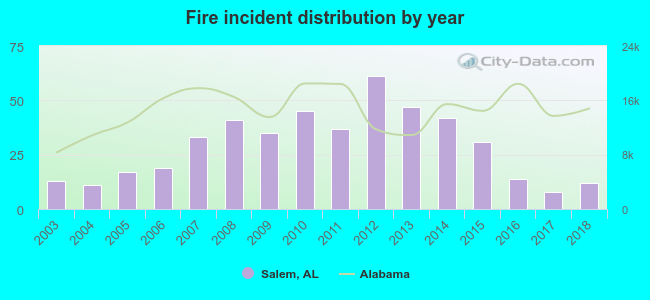 According to the data from the years 2003 - 2018 the average number of fire incidents per year is 29. The highest number of reported fires - 61 took place in 2012, and the least - 8 in 2017. The data has a declining trend.
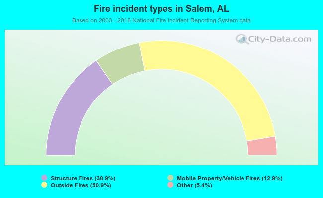 When looking into fire subcategories, the most incidents belonged to: Outside Fires (50.9%), and Structure Fires (30.9%).
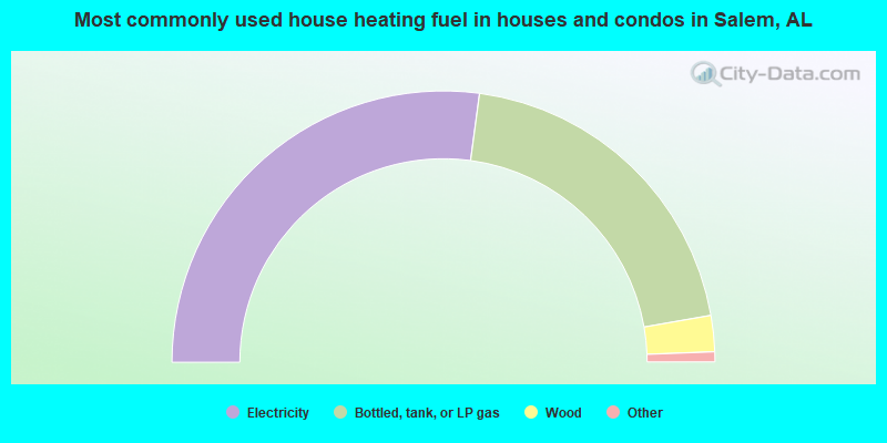
- 54.2%Electricity
- 40.2%Bottled, tank, or LP gas
- 4.3%Wood
- 0.7%Fuel oil, kerosene, etc.
- 0.5%Utility gas
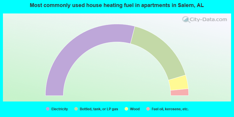
- 58.0%Electricity
- 32.6%Bottled, tank, or LP gas
- 6.2%Wood
- 3.1%Fuel oil, kerosene, etc.
Salem compared to Alabama state average:
- Unemployed percentage significantly below state average.
- Black race population percentage significantly below state average.
- Hispanic race population percentage significantly below state average.
- Median age below state average.
- Foreign-born population percentage significantly below state average.
- Renting percentage below state average.
- Length of stay since moving in significantly above state average.
- Number of rooms per house significantly below state average.
- House age significantly below state average.
- Number of college students below state average.
- Percentage of population with a bachelor's degree or higher significantly below state average.
Salem on our top lists:
- #56 on the list of "Top 101 larger cities with the lowest real estate taxes percentage (population 50,000+)"
- #4 on the list of "Top 101 counties with the largest number of people moving in compared to moving out (pop. 50,000+)"
- #81 on the list of "Top 101 counties with highest percentage of residents voting for Romney (Republican) in the 2012 Presidential Election (pop. 50,000+)"

|
|
Total of 10 patent applications in 2008-2024.