Sandisfield, Massachusetts
Submit your own pictures of this town and show them to the world
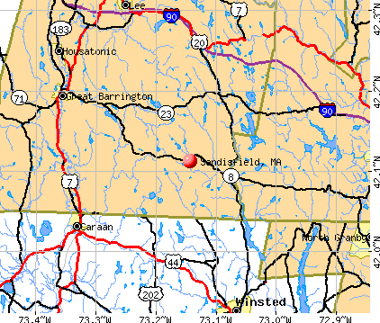
- OSM Map
- General Map
- Google Map
- MSN Map
Population change since 2000: +11.0%
 |
| Males: 490 | |
| Females: 425 |
| Median resident age: | 49.9 years |
| Massachusetts median age: | 39.2 years |
Zip codes: 01255.
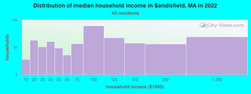
| Sandisfield: | $87,331 |
| MA: | $94,488 |
Estimated per capita income in 2022: $61,969 (it was $27,628 in 2000)
Sandisfield town income, earnings, and wages data
Estimated median house or condo value in 2022: $420,651 (it was $157,300 in 2000)
| Sandisfield: | $420,651 |
| MA: | $534,700 |
Mean prices in 2022: all housing units: $357,971; detached houses: $376,086; townhouses or other attached units: $341,816; in 2-unit structures: $250,940; in 3-to-4-unit structures: $400,871; in 5-or-more-unit structures: $281,990; mobile homes: $80,872
Detailed information about poverty and poor residents in Sandisfield, MA


- 87595.6%White alone
- 111.2%Two or more races
- 101.1%Hispanic
- 80.9%Black alone
- 70.8%Asian alone
- 20.2%Native Hawaiian and Other
Pacific Islander alone - 20.2%Other race alone
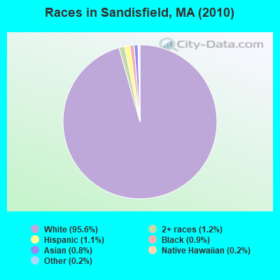
Races in Sandisfield detailed stats: ancestries, foreign born residents, place of birth
According to our research of Massachusetts and other state lists, there were 3 registered sex offenders living in Sandisfield, Massachusetts as of April 23, 2024.
The ratio of all residents to sex offenders in Sandisfield is 305 to 1.
 Recent articles from our blog. Our writers, many of them Ph.D. graduates or candidates, create easy-to-read articles on a wide variety of topics.

 | MA ranked most prosperous state (123 replies) |
| Is it possible to escape hunters, ATVs and noise in a rural area? (278 replies) |
| Are snow tires in MA necessary? (69 replies) |
| How Much Massachusetts Households Make Per Year: Census Data (37 replies) |
| Why Would You or Wouldn’t You Choose to Live More Rurally? (63 replies) |
| Most redneck town in Mass is... (81 replies) |
Latest news from Sandisfield, MA collected exclusively by city-data.com from local newspapers, TV, and radio stations
Ancestries: English (16.7%), Irish (15.7%), German (14.2%), Italian (12.0%), French (10.4%), United States (7.8%).
Current Local Time: EST time zone
Incorporated in 1762
Elevation: 1577 feet
Land area: 52.3 square miles.
Population density: 17 people per square mile (very low).
21 residents are foreign born (1.8% Europe, 0.4% Africa, 0.4% North America).
| This town: | 2.5% |
| Massachusetts: | 12.2% |
| Sandisfield town: | 0.8% ($1,200) |
| Massachusetts: | 1.3% ($2,336) |
Nearest city with pop. 50,000+: Chicopee, MA  (27.2 miles , pop. 54,653).
Nearest city with pop. 200,000+: Bronx, NY (96.3 miles , pop. 1,332,650).
Nearest cities:
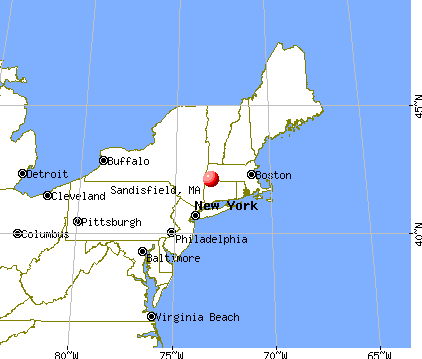
), ), ), ), )Latitude: 42.12 N, Longitude: 73.11 W
Area code: 413

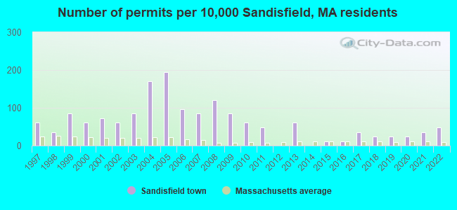
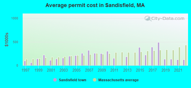
Single-family new house construction building permits:
- 2022: 4 buildings, average cost: $125,800
- 2021: 3 buildings, average cost: $125,800
- 2020: 2 buildings, average cost: $138,000
- 2019: 2 buildings, average cost: $138,000
- 2018: 2 buildings, average cost: $489,000
- 2017: 3 buildings, average cost: $392,700
- 2016: 1 building, cost: $225,000
- 2015: 1 building, cost: $384,700
- 2013: 5 buildings, average cost: $188,400
- 2011: 4 buildings, average cost: $156,400
- 2010: 5 buildings, average cost: $303,500
- 2009: 7 buildings, average cost: $254,900
- 2008: 10 buildings, average cost: $260,800
- 2007: 7 buildings, average cost: $323,600
- 2006: 8 buildings, average cost: $257,500
- 2005: 16 buildings, average cost: $212,000
- 2004: 14 buildings, average cost: $200,600
- 2003: 7 buildings, average cost: $158,500
- 2002: 5 buildings, average cost: $144,000
- 2001: 6 buildings, average cost: $113,300
- 2000: 5 buildings, average cost: $225,200
- 1999: 7 buildings, average cost: $143,600
- 1998: 3 buildings, average cost: $62,900
- 1997: 5 buildings, average cost: $97,000
| Here: | 2.7% |
| Massachusetts: | 3.5% |
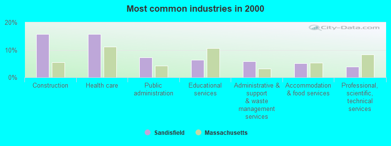
- Construction (15.8%)
- Health care (15.8%)
- Public administration (7.3%)
- Educational services (6.3%)
- Administrative & support & waste management services (5.8%)
- Accommodation & food services (5.1%)
- Professional, scientific, technical services (3.9%)
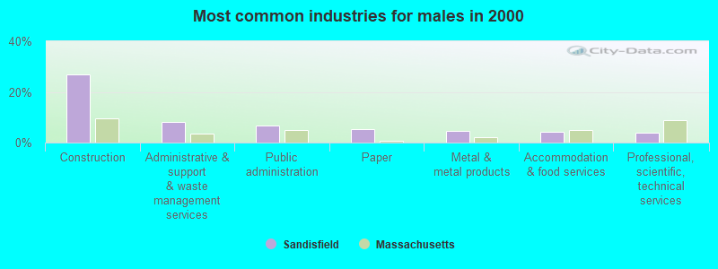
- Construction (26.9%)
- Administrative & support & waste management services (8.3%)
- Public administration (6.6%)
- Paper (5.4%)
- Metal & metal products (4.5%)
- Accommodation & food services (4.1%)
- Professional, scientific, technical services (3.7%)
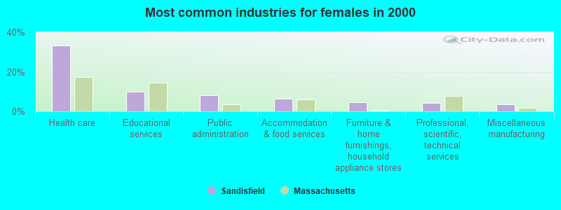
- Health care (33.1%)
- Educational services (10.1%)
- Public administration (8.3%)
- Accommodation & food services (6.5%)
- Furniture & home furnishings, household appliance stores (4.7%)
- Professional, scientific, technical services (4.1%)
- Miscellaneous manufacturing (3.6%)
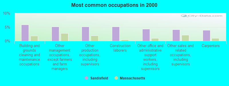
- Building and grounds cleaning and maintenance occupations (5.8%)
- Other management occupations, except farmers and farm managers (5.1%)
- Other production occupations, including supervisors (5.1%)
- Construction laborers (5.1%)
- Other office and administrative support workers, including supervisors (4.4%)
- Other sales and related occupations, including supervisors (4.1%)
- Carpenters (3.9%)

- Construction laborers (8.7%)
- Building and grounds cleaning and maintenance occupations (7.0%)
- Carpenters (6.6%)
- Other production occupations, including supervisors (6.6%)
- Driver/sales workers and truck drivers (5.4%)
- Other sales and related occupations, including supervisors (4.5%)
- Other management occupations, except farmers and farm managers (4.1%)
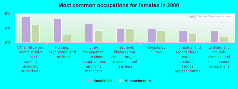
- Other office and administrative support workers, including supervisors (8.9%)
- Nursing, psychiatric, and home health aides (8.3%)
- Other management occupations, except farmers and farm managers (6.5%)
- Preschool, kindergarten, elementary, and middle school teachers (4.7%)
- Registered nurses (4.7%)
- Information and record clerks, except customer service representatives (4.1%)
- Building and grounds cleaning and maintenance occupations (4.1%)
Average climate in Sandisfield, Massachusetts
Based on data reported by over 4,000 weather stations


(lower is better)
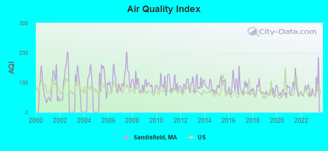
Air Quality Index (AQI) level in 2022 was 70.7. This is about average.
| City: | 70.7 |
| U.S.: | 72.6 |
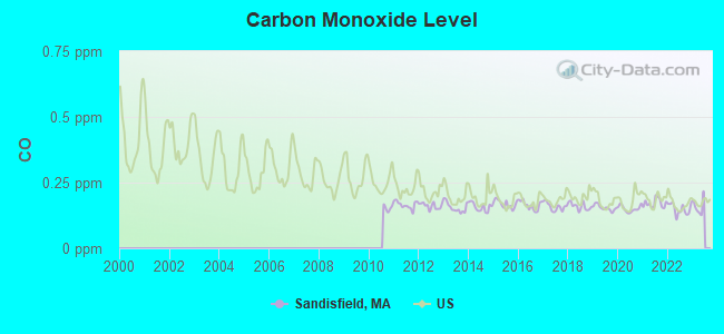
Carbon Monoxide (CO) [ppm] level in 2022 was 0.149. This is significantly better than average. Closest monitor was 21.5 miles away from the city center.
| City: | 0.149 |
| U.S.: | 0.251 |
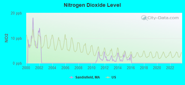
Nitrogen Dioxide (NO2) [ppb] level in 2015 was 2.27. This is significantly better than average. Closest monitor was 13.2 miles away from the city center.
| City: | 2.27 |
| U.S.: | 5.11 |
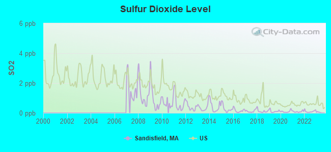
Sulfur Dioxide (SO2) [ppb] level in 2022 was 0.109. This is significantly better than average. Closest monitor was 13.2 miles away from the city center.
| City: | 0.109 |
| U.S.: | 1.515 |
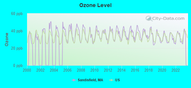
Ozone [ppb] level in 2022 was 32.8. This is about average. Closest monitor was 19.3 miles away from the city center.
| City: | 32.8 |
| U.S.: | 33.3 |
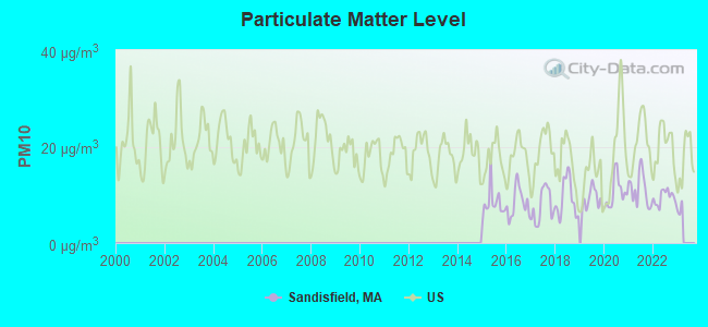
Particulate Matter (PM10) [µg/m3] level in 2022 was 9.49. This is significantly better than average. Closest monitor was 21.8 miles away from the city center.
| City: | 9.49 |
| U.S.: | 19.21 |
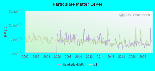
Particulate Matter (PM2.5) [µg/m3] level in 2022 was 5.73. This is significantly better than average. Closest monitor was 22.5 miles away from the city center.
| City: | 5.73 |
| U.S.: | 8.11 |
Tornado activity:
Sandisfield-area historical tornado activity is above Massachusetts state average. It is 13% smaller than the overall U.S. average.
On 5/29/1995, a category F4 (max. wind speeds 207-260 mph) tornado 4.6 miles away from the Sandisfield town center killed 3 people and injured 24 people and caused between $5,000,000 and $50,000,000 in damages.
On 8/28/1973, a category F4 tornado 17.2 miles away from the town center killed 4 people and injured 36 people and caused between $5,000,000 and $50,000,000 in damages.
Earthquake activity:
Sandisfield-area historical earthquake activity is significantly above Massachusetts state average. It is 69% smaller than the overall U.S. average.On 10/7/1983 at 10:18:46, a magnitude 5.3 (5.1 MB, 5.3 LG, 5.1 ML, Class: Moderate, Intensity: VI - VII) earthquake occurred 141.3 miles away from the city center
On 4/20/2002 at 10:50:47, a magnitude 5.3 (5.3 ML, Depth: 3.0 mi) earthquake occurred 168.2 miles away from the city center
On 4/20/2002 at 10:50:47, a magnitude 5.2 (5.2 MB, 4.2 MS, 5.2 MW, 5.0 MW) earthquake occurred 166.7 miles away from Sandisfield center
On 1/19/1982 at 00:14:42, a magnitude 4.7 (4.5 MB, 4.7 MD, 4.5 LG, Class: Light, Intensity: IV - V) earthquake occurred 122.7 miles away from the city center
On 10/16/2012 at 23:12:25, a magnitude 4.7 (4.7 ML, Depth: 10.0 mi) earthquake occurred 161.3 miles away from the city center
On 8/23/2011 at 17:51:04, a magnitude 5.8 (5.8 MW, Depth: 3.7 mi) earthquake occurred 387.1 miles away from Sandisfield center
Magnitude types: regional Lg-wave magnitude (LG), body-wave magnitude (MB), duration magnitude (MD), local magnitude (ML), surface-wave magnitude (MS), moment magnitude (MW)
Natural disasters:
The number of natural disasters in Berkshire County (21) is greater than the US average (15).Major Disasters (Presidential) Declared: 10
Emergencies Declared: 10
Causes of natural disasters: Floods: 5, Snowstorms: 5, Storms: 5, Hurricanes: 4, Winter Storms: 4, Blizzards: 2, Snows: 2, Snowfall: 1, Tropical Storm: 1, Wind: 1, Other: 1 (Note: some incidents may be assigned to more than one category).

Hospitals and medical centers in Sandisfield:
Other hospitals and medical centers near Sandisfield:
- C R I - SPENCER HILL ROAD (Hospital, about 13 miles away; WINSTED, CT)
- C R I BOYD STREET (Hospital, about 14 miles away; WINSTED, CT)
- FOOTHILLS VN HOME CARE INC (Home Health Center, about 14 miles away; WINSTED, CT)
- FOOTHILLS VISITING NURSE AND H (Hospital, about 14 miles away; WINSTED, CT)
- FAIRVIEW HOSPITAL DIALYSIS CENTER (Dialysis Facility, about 14 miles away; GREAT BARRINGTON, MA)
- HIGHLAND ACRES R H (Nursing Home, about 14 miles away; WINSTED, CT)
- LAUREL HILL HEALTHCARE (Nursing Home, about 14 miles away; WINSTED, CT)
Colleges/universities with over 2000 students nearest to Sandisfield:
- Westfield State University (about 17 miles; Westfield, MA; Full-time enrollment: 5,548)
- Holyoke Community College (about 25 miles; Holyoke, MA; FT enrollment: 4,911)
- Springfield Technical Community College (about 28 miles; Springfield, MA; FT enrollment: 4,750)
- Bay Path College (about 28 miles; Longmeadow, MA; FT enrollment: 2,085)
- Smith College (about 29 miles; Northampton, MA; FT enrollment: 3,549)
- American International College (about 29 miles; Springfield, MA; FT enrollment: 2,733)
- Springfield College (about 29 miles; Springfield, MA; FT enrollment: 3,144)
Points of interest:
Notable locations in Sandisfield: Free Quarter (A), Sandisfield Fire Department Station 2 (B), Sandisfield Fire Department Station 1 Headquarters (C), West New Boston Town Hall (D). Display/hide their locations on the map
Cemeteries: Montville Cemetery (1), Roberts Cemetery (2), Beech Plain Cemetery (3). Display/hide their locations on the map
Lakes, reservoirs, and swamps: Spectacle Ponds (A), Lake Marguerite (B), Mirror Lake (C), Abbey Lake (D), West Lake (E), Lower Spectacle Pond (F), Upper Spectacle Pond (G), Gilder Pond (H). Display/hide their locations on the map
Streams, rivers, and creeks: Thorp Brook (A), Spectacle Pond Brook (B), Silver Brook (C), Moody Brook (D), Clam River (E), Buck River (F), Cherry Brook (G), Riiska Brook (H). Display/hide their locations on the map
Birthplace of: Barnas Sears - Educationist.
| This town: | 2.3 people |
| Massachusetts: | 2.5 people |
| This town: | 66.3% |
| Whole state: | 63.0% |
| This town: | 6.6% |
| Whole state: | 7.0% |
Likely homosexual households (counted as self-reported same-sex unmarried-partner households)
- Lesbian couples: 0.5% of all households
- Gay men: 0.3% of all households
| This town: | 2.4% |
| Whole state: | 9.3% |
| This town: | 0.6% |
| Whole state: | 4.4% |
48 people in nursing homes in 2000
2 people in homes for the mentally retarded in 2000
For population 15 years and over in Sandisfield:
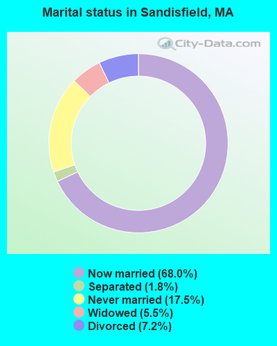
- Never married: 17.5%
- Now married: 68.0%
- Separated: 1.8%
- Widowed: 5.5%
- Divorced: 7.2%
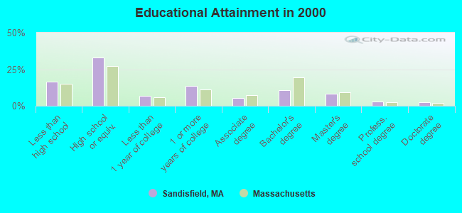
For population 25 years and over in Sandisfield:
- High school or higher: 83.3%
- Bachelor's degree or higher: 24.7%
- Graduate or professional degree: 13.9%
- Unemployed: 1.7%
- Mean travel time to work (commute): 37.0 minutes
| Here: | 11.6 |
| Massachusetts average: | 13.1 |


Graphs represent county-level data. Detailed 2008 Election Results
Religion statistics for Sandisfield, MA (based on Berkshire County data)


| Religion | Adherents | Congregations |
|---|---|---|
| Catholic | 50,187 | 32 |
| Mainline Protestant | 9,895 | 63 |
| Other | 3,647 | 20 |
| Evangelical Protestant | 2,817 | 28 |
| Black Protestant | 233 | 2 |
| Orthodox | 225 | 2 |
| None | 64,215 | - |
Food Environment Statistics:
| Berkshire County: | 2.54 / 10,000 pop. |
| Massachusetts: | 1.98 / 10,000 pop. |
| Here: | 1.61 / 10,000 pop. |
| State: | 2.22 / 10,000 pop. |
| Berkshire County: | 4.08 / 10,000 pop. |
| Massachusetts: | 1.77 / 10,000 pop. |
| Here: | 15.00 / 10,000 pop. |
| State: | 8.76 / 10,000 pop. |
| This county: | 8.0% |
| Massachusetts: | 8.1% |
| Berkshire County: | 22.8% |
| Massachusetts: | 22.5% |
| Berkshire County: | 9.9% |
| Massachusetts: | 16.5% |
Strongest AM radio stations in Sandisfield:
- WNNZ (640 AM; 50 kW; WESTFIELD, MA; Owner: CLEAR CHANNEL BROADCASTING LICENSES, INC.)
- WTIC (1080 AM; 50 kW; HARTFORD, CT; Owner: INFINITY RADIO OPERATIONS INC.)
- WSBS (860 AM; 3 kW; GREAT BARRINGTON, MA; Owner: BERKSHIRE BROADCASTING CO., INC.)
- WHYN (560 AM; 5 kW; SPRINGFIELD, MA; Owner: CLEAR CHANNEL BROADCASTING LICENSES, INC.)
- WCRN (830 AM; 50 kW; WORCESTER, MA; Owner: CARTER BROADCASTING CORPORATION)
- WGY (810 AM; 50 kW; SCHENECTADY, NY; Owner: CLEAR CHANNEL BROADCASTING LICENSES, INC.)
- WVNE (760 AM; daytime; 25 kW; LEICESTER, MA; Owner: BLOUNT MASSCOM, INC.)
- WACE (730 AM; 5 kW; CHICOPEE, MA; Owner: CARTER BROADCASTING CORP.)
- WPTR (1540 AM; 50 kW; ALBANY, NY; Owner: KIMTRON, INC.)
- WFAN (660 AM; 50 kW; NEW YORK, NY; Owner: INFINITY BROADCASTING OPERATIONS, INC.)
- WALE (990 AM; 50 kW; GREENVILLE, RI; Owner: NORTH AMERICAN BROADCASTING CO., INC.)
- WUHN (1110 AM; daytime; 5 kW; PITTSFIELD, MA; Owner: WEINER BROADCASTING, INC.)
- WMCA (570 AM; 50 kW; NEW YORK, NY; Owner: SALEM MEDIA OF NEW YORK, LLC)
Strongest FM radio stations in Sandisfield:
- WAMQ (105.1 FM; GREAT BARRINGTON, MA; Owner: WAMC)
- WAMC-FM (90.3 FM; ALBANY, NY; Owner: WAMC)
- WHVP (91.1 FM; HUDSON, NY; Owner: SOUND OF LIFE, INC.)
- WHYN-FM (93.1 FM; SPRINGFIELD, MA; Owner: CLEAR CHANNEL BROADCASTING LICENSES, INC.)
- WAQY (102.1 FM; SPRINGFIELD, MA; Owner: SAGA COMMUNICATIONS OF NEW ENGLAND, LLC)
- WRCH (100.5 FM; NEW BRITAIN, CT; Owner: INFINITY RADIO OPERATIONS INC.)
- WRNX (100.9 FM; AMHERST, MA; Owner: WESTERN MASSACHUSETTS RADIO COMPANY)
- WBEC-FM (105.5 FM; PITTSFIELD, MA; Owner: GREAT NORTHERN RADIO, LLC)
- WSGG (89.3 FM; NORFOLK, CT; Owner: REVIVAL CHRISTIAN MINISTRIES, INC.)
- WTIC-FM (96.5 FM; HARTFORD, CT; Owner: INFINITY RADIO OPERATIONS INC.)
- WPKX (97.9 FM; ENFIELD, CT; Owner: CAPSTAR TX LIMITED PARTNERSHIP)
- WWUH (91.3 FM; WEST HARTFORD, CT; Owner: UNIVERSITY OF HARTFORD)
- WUPE (95.9 FM; PITTSFIELD, MA; Owner: WEINER BROADCASTING, INC.)
- WCCC-FM (106.9 FM; HARTFORD, CT; Owner: MARLIN BROADCASTING, LLC)
- WAMK (90.9 FM; KINGSTON, NY; Owner: W A M C)
- WJMJ (88.9 FM; HARTFORD, CT; Owner: ST. THOMAS SEMINARY)
- WFGB (89.7 FM; KINGSTON, NY; Owner: SOUND OF LIFE, INC.)
- WPDH (101.5 FM; POUGHKEEPSIE, NY; Owner: CUMULUS LICENSING CORP.)
- WKZE-FM (98.1 FM; SALISBURY, CT; Owner: JOHNSON DEVELOPMENT, INC.)
- WFCR (88.5 FM; AMHERST, MA; Owner: UNIVERSITY OF MASSACHUSETTS)
TV broadcast stations around Sandisfield:
- WTIC-TV (Channel 61; HARTFORD, CT; Owner: TRIBUNE TELEVISION COMPANY)
- W11BJ (Channel 11; HARTFORD, CT; Owner: COMMUNICATIONS SITE MANAGEMENT LLC)
- WTXX (Channel 20; WATERBURY, CT; Owner: WTXX INC.)
- WUVN (Channel 18; HARTFORD, CT; Owner: ENTRAVISION HOLDINGS, LLC)
- WVIT (Channel 30; NEW BRITAIN, CT; Owner: OUTLET BROADCASTING, INC)
- WEDH (Channel 24; HARTFORD, CT; Owner: CONNECTICUT PUBLIC BROADCASTING, INC.)
- WWLP (Channel 22; SPRINGFIELD, MA; Owner: WWLP BROADCASTING, LLC)
- WFSB (Channel 3; HARTFORD, CT; Owner: MEREDITH CORPORATION)
- WYDN (Channel 48; WORCESTER, MA; Owner: EDUCATIONAL PUBLIC TV CORPORATION)
- W67DF (Channel 67; SPRINGFIELD, MA; Owner: TRINITY BROADCASTING NETWORK)
- WHCT-LP (Channel 38; HARTFORD, CT; Owner: VENTURE TECHNOLOGIES GROUP, LLC)
- Sandisfield, Massachusetts
- Fatal accident count17
- Vehicles involved in fatal accidents25
- Fatal accidents involving drunk persons:4
- Fatalities19
- Persons involved in fatal accidents34
- Pedestrians involved in fatal accidents0
- Massachusetts average
- Fatal accident count6383
- Vehicles involved in fatal accidents9023
- Fatal accidents involving drunk persons2262
- Fatalities6904
- Persons involved in fatal accidents14474
- Pedestrians involved in fatal accidents393
- National Bridge Inventory (NBI) Statistics
- 21Number of bridges
- 131ft / 39.7mTotal length
- $20,806,000Total costs
- 14,458Total average daily traffic
- 1,424Total average daily truck traffic
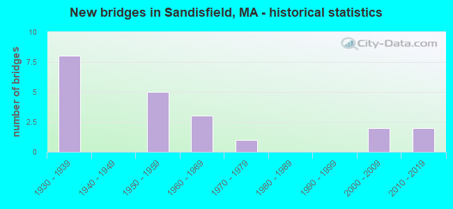
- New bridges - historical statistics
- 81930-1939
- 51950-1959
- 31960-1969
- 11970-1979
- 22000-2009
- 22010-2019
FCC Registered Microwave Towers:
1- STATION, Lat: 42.166750 Lon: -73.082861, Overall height: 6.1 m, Call Sign: WNTR722,
Assigned Frequencies: 956.306 MHz, Grant Date: 05/02/2018, Expiration Date: 06/30/2028, Registrant: Utilities Technology Council, 1129 20th Street Nw, Suite 350, Washington, DC 20036, Phone: (202) 872-0030, Fax: (202) 872-1331, Email:
FCC Registered Amateur Radio Licenses:
8 (See the full list of FCC Registered Amateur Radio Licenses in Sandisfield)2002 - 2018 National Fire Incident Reporting System (NFIRS) incidents
- Fire incident types reported to NFIRS in Sandisfield, MA
- 6452.5%Structure Fires
- 4335.2%Outside Fires
- 86.6%Other
- 75.7%Mobile Property/Vehicle Fires
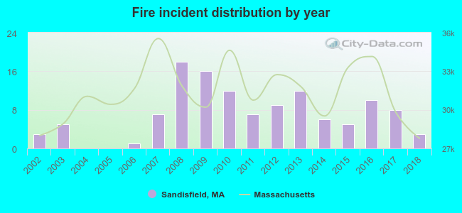 Based on the data from the years 2002 - 2018 the average number of fires per year is 7. The highest number of reported fires - 18 took place in 2008, and the least - 0 in 2004. The data has a constant trend.
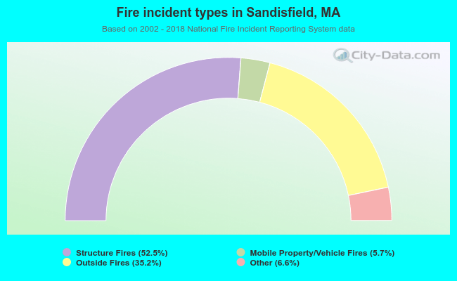 When looking into fire subcategories, the most reports belonged to: Structure Fires (52.5%), and Outside Fires (35.2%).
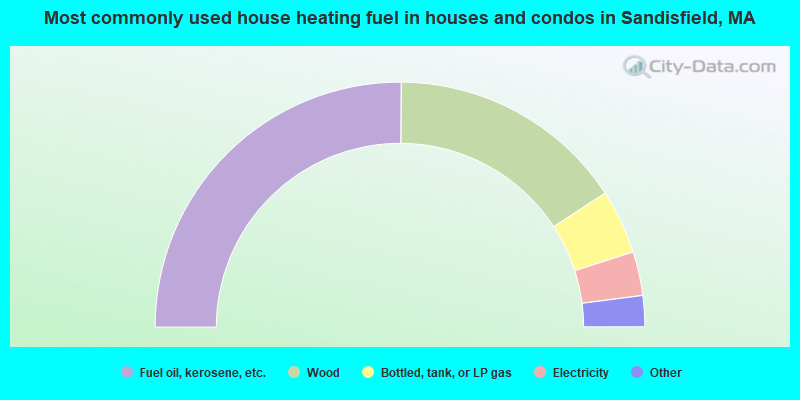
- 50.2%Fuel oil, kerosene, etc.
- 31.4%Wood
- 8.5%Bottled, tank, or LP gas
- 5.8%Electricity
- 3.4%Utility gas
- 0.7%Other fuel
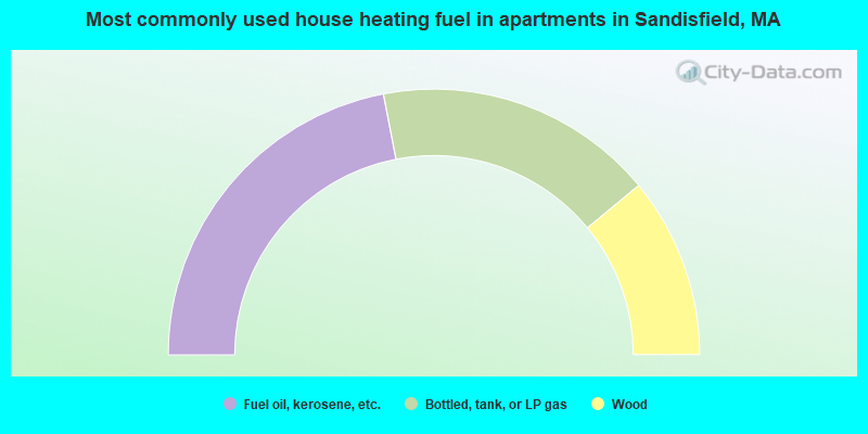
- 43.9%Fuel oil, kerosene, etc.
- 34.1%Bottled, tank, or LP gas
- 22.0%Wood
Sandisfield compared to Massachusetts state average:
- Unemployed percentage significantly below state average.
- Black race population percentage significantly below state average.
- Hispanic race population percentage significantly below state average.
- Median age significantly above state average.
- Foreign-born population percentage significantly below state average.
- Renting percentage significantly below state average.
- Length of stay since moving in significantly above state average.
- Number of rooms per house significantly below state average.
- House age significantly below state average.
- Institutionalized population percentage significantly above state average.
- Number of college students below state average.

|
Total of 9 patent applications in 2008-2024.