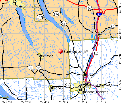
Sempronius, New York
Submit your own pictures of this town and show them to the world
- OSM Map
- General Map
- Google Map
- MSN Map
Population change since 2000: +0.2%
 |
| Males: 478 | |
| Females: 417 |
| Median resident age: | 39.7 years |
| New York median age: | 40.7 years |
Zip codes: 13118.
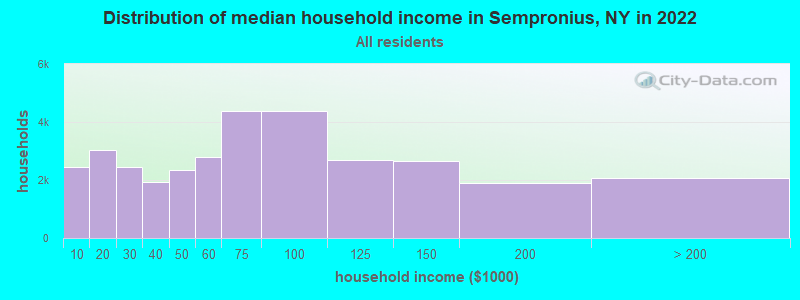
| Sempronius: | $65,951 |
| NY: | $79,557 |
Estimated per capita income in 2022: $30,200 (it was $15,365 in 2000)
Sempronius town income, earnings, and wages data
Estimated median house or condo value in 2022: $130,084 (it was $57,300 in 2000)
| Sempronius: | $130,084 |
| NY: | $400,400 |
Mean prices in 2022: all housing units: $208,264; detached houses: $225,118; townhouses or other attached units: $236,740; in 2-unit structures: $244,571; in 3-to-4-unit structures: $414,744; in 5-or-more-unit structures: $633,100; mobile homes: $69,131
Detailed information about poverty and poor residents in Sempronius, NY


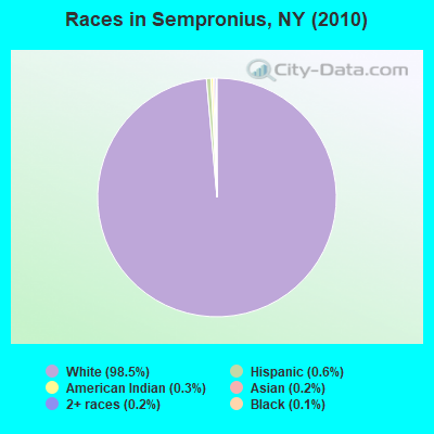
- 88298.5%White alone
- 50.6%Hispanic
- 30.3%American Indian alone
- 20.2%Asian alone
- 20.2%Two or more races
- 10.1%Black alone
Races in Sempronius detailed stats: ancestries, foreign born residents, place of birth
 Recent articles from our blog. Our writers, many of them Ph.D. graduates or candidates, create easy-to-read articles on a wide variety of topics.

 | Do you consider Yates county to be a part of the southern tier? (9 replies) |
| Why do so many places Upstate have Greco-Roman names? (9 replies) |
| boating, skiing, and things to do (3 replies) |
| Consolidation.......... (4 replies) |
Latest news from Sempronius, NY collected exclusively by city-data.com from local newspapers, TV, and radio stations
Ancestries: English (19.9%), German (17.1%), Irish (16.0%), United States (7.2%), French (6.0%), Dutch (4.5%).
Current Local Time: EST time zone
Land area: 29.4 square miles.
Population density: 30 people per square mile (very low).
9 residents are foreign born
| This town: | 1.0% |
| New York: | 20.4% |
| Sempronius town: | 2.3% ($1,343) |
| New York: | 1.9% ($2,847) |
Nearest city with pop. 50,000+: Syracuse, NY  (24.1 miles , pop. 147,306).
Nearest city with pop. 200,000+: Rochester, NY (71.5 miles , pop. 219,773).
Nearest city with pop. 1,000,000+: Bronx, NY (181.6 miles , pop. 1,332,650).
Nearest cities:
), ), ), Latitude: 42.73 N, Longitude: 76.33 W
Area code: 315

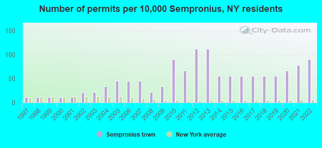
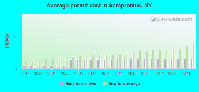
Single-family new house construction building permits:
- 2022: 8 buildings, average cost: $150,000
- 2021: 7 buildings, average cost: $150,000
- 2020: 6 buildings, average cost: $150,000
- 2019: 5 buildings, average cost: $150,000
- 2018: 5 buildings, average cost: $150,000
- 2017: 5 buildings, average cost: $150,000
- 2016: 5 buildings, average cost: $150,000
- 2015: 5 buildings, average cost: $150,000
- 2014: 5 buildings, average cost: $150,000
- 2013: 10 buildings, average cost: $150,000
- 2012: 10 buildings, average cost: $150,000
- 2011: 6 buildings, average cost: $150,000
- 2010: 8 buildings, average cost: $150,000
- 2009: 3 buildings, average cost: $141,700
- 2008: 2 buildings, average cost: $141,700
- 2007: 4 buildings, average cost: $141,700
- 2006: 4 buildings, average cost: $141,700
- 2005: 4 buildings, average cost: $141,700
- 2004: 3 buildings, average cost: $141,700
- 2003: 2 buildings, average cost: $50,000
- 2002: 2 buildings, average cost: $50,000
- 2001: 1 building, cost: $50,000
- 2000: 1 building, cost: $50,000
- 1999: 1 building, cost: $50,000
- 1998: 1 building, cost: $50,000
- 1997: 1 building, cost: $50,000
| Here: | 4.2% |
| New York: | 4.4% |
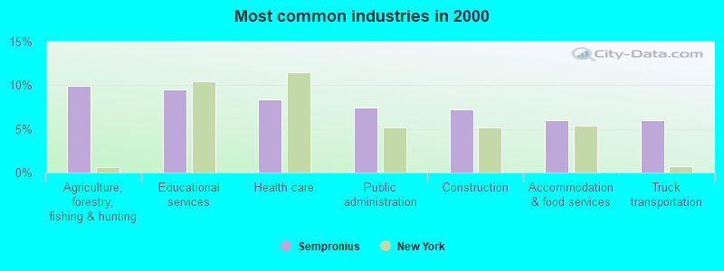
- Agriculture, forestry, fishing & hunting (10.0%)
- Educational services (9.5%)
- Health care (8.4%)
- Public administration (7.4%)
- Construction (7.2%)
- Accommodation & food services (6.0%)
- Truck transportation (6.0%)
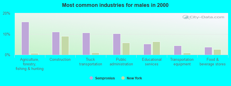
- Agriculture, forestry, fishing & hunting (15.9%)
- Construction (11.0%)
- Truck transportation (10.6%)
- Public administration (10.2%)
- Educational services (5.3%)
- Transportation equipment (4.5%)
- Food & beverage stores (3.7%)
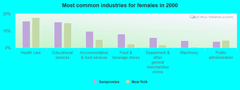
- Health care (15.7%)
- Educational services (15.1%)
- Accommodation & food services (9.7%)
- Food & beverage stores (8.1%)
- Department & other general merchandise stores (5.9%)
- Machinery (4.3%)
- Public administration (3.8%)
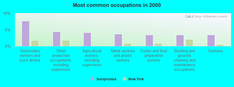
- Driver/sales workers and truck drivers (7.7%)
- Other production occupations, including supervisors (4.4%)
- Agricultural workers, including supervisors (4.2%)
- Metal workers and plastic workers (3.7%)
- Cooks and food preparation workers (3.5%)
- Building and grounds cleaning and maintenance occupations (3.5%)
- Cashiers (3.5%)
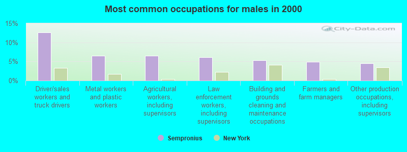
- Driver/sales workers and truck drivers (12.6%)
- Metal workers and plastic workers (6.5%)
- Agricultural workers, including supervisors (6.5%)
- Law enforcement workers, including supervisors (6.1%)
- Building and grounds cleaning and maintenance occupations (5.3%)
- Farmers and farm managers (4.9%)
- Other production occupations, including supervisors (4.5%)
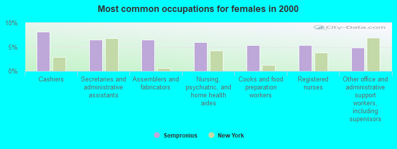
- Cashiers (8.1%)
- Secretaries and administrative assistants (6.5%)
- Assemblers and fabricators (6.5%)
- Nursing, psychiatric, and home health aides (5.9%)
- Cooks and food preparation workers (5.4%)
- Registered nurses (5.4%)
- Other office and administrative support workers, including supervisors (4.9%)
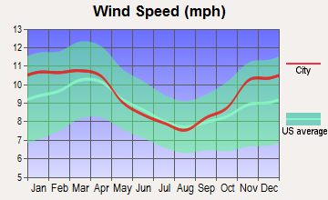
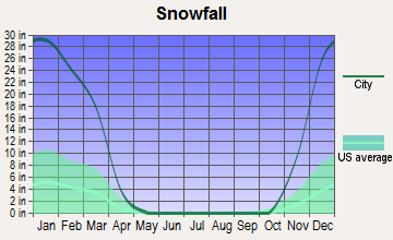
Average climate in Sempronius, New York
Based on data reported by over 4,000 weather stations


(lower is better)
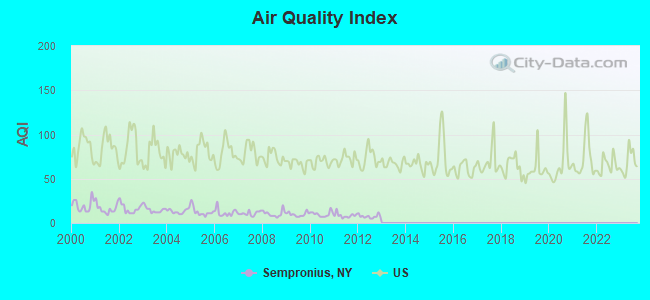
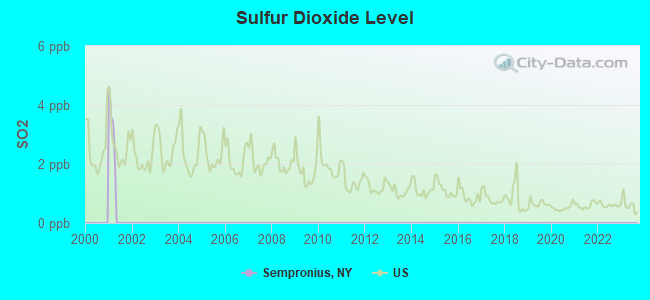
Air Quality Index (AQI) level in 2012 was 7.49. This is significantly better than average.
| City: | 7.49 |
| U.S.: | 72.56 |
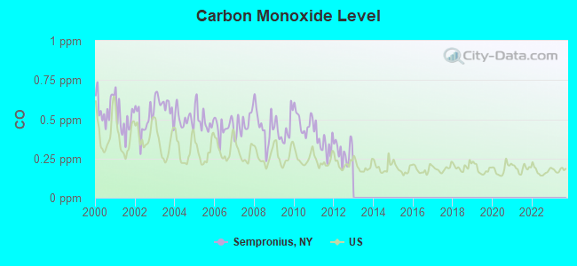
Carbon Monoxide (CO) [ppm] level in 2012 was 0.295. This is about average. Closest monitor was 23.8 miles away from the city center.
| City: | 0.295 |
| U.S.: | 0.251 |
Tornado activity:
Sempronius-area historical tornado activity is slightly below New York state average. It is 72% smaller than the overall U.S. average.
On 5/2/1983, a category F3 (max. wind speeds 158-206 mph) tornado 33.7 miles away from the Sempronius town center killed one person and caused between $500,000 and $5,000,000 in damages.
On 5/2/1983, a category F3 tornado 34.8 miles away from the town center caused between $50,000 and $500,000 in damages.
Earthquake activity:
Sempronius-area historical earthquake activity is significantly above New York state average. It is 67% smaller than the overall U.S. average.On 10/7/1983 at 10:18:46, a magnitude 5.3 (5.1 MB, 5.3 LG, 5.1 ML, Class: Moderate, Intensity: VI - VII) earthquake occurred 131.2 miles away from Sempronius center
On 4/20/2002 at 10:50:47, a magnitude 5.3 (5.3 ML, Depth: 3.0 mi) earthquake occurred 180.7 miles away from Sempronius center
On 4/20/2002 at 10:50:47, a magnitude 5.2 (5.2 MB, 4.2 MS, 5.2 MW, 5.0 MW) earthquake occurred 178.7 miles away from Sempronius center
On 9/25/1998 at 19:52:52, a magnitude 5.2 (4.8 MB, 4.3 MS, 5.2 LG, 4.5 MW, Depth: 3.1 mi) earthquake occurred 225.4 miles away from the city center
On 8/23/2011 at 17:51:04, a magnitude 5.8 (5.8 MW, Depth: 3.7 mi) earthquake occurred 343.8 miles away from Sempronius center
On 1/16/1994 at 01:49:16, a magnitude 4.6 (4.6 MB, 4.6 LG, Depth: 3.1 mi, Class: Light, Intensity: IV - V) earthquake occurred 166.5 miles away from Sempronius center
Magnitude types: regional Lg-wave magnitude (LG), body-wave magnitude (MB), local magnitude (ML), surface-wave magnitude (MS), moment magnitude (MW)
Natural disasters:
The number of natural disasters in Cayuga County (15) is near the US average (15).Major Disasters (Presidential) Declared: 8
Emergencies Declared: 6
Causes of natural disasters: Floods: 5, Storms: 4, Hurricanes: 2, Blizzard: 1, Heavy Rain: 1, Ice Storm: 1, Landslide: 1, Power Outage: 1, Snow: 1, Tropical Storm: 1, Wind: 1, Other: 2 (Note: some incidents may be assigned to more than one category).
Hospitals and medical centers near Sempronius:
- GROTON COMMUNITY HEALTH CARE CTR R C F (Nursing Home, about 11 miles away; GROTON, NY)
- ST. JOSEPH'S - CORTLAND (Dialysis Facility, about 11 miles away; CORTLAND, NY)
- CORTLAND REGIONAL MEDICAL CENTER, INC Acute Care Hospitals (about 12 miles away; CORTLAND, NY)
- CORTLAND PARK REHABILITATION AND NURSING CENTER (Nursing Home, about 12 miles away; CORTLAND, NY)
- CARING COMMUNITY HOSPICE OF CORTLAND (Hospital, about 12 miles away; CORTLAND, NY)
- CORTLAND COUNTY HEALTH DEPARTMENT (Home Health Center, about 12 miles away; CORTLAND, NY)
- CROWN CENTER FOR NURSING AND REHABILITATION (Nursing Home, about 13 miles away; CORTLAND, NY)
Colleges/universities with over 2000 students nearest to Sempronius:
- SUNY College at Cortland (about 12 miles; Cortland, NY; Full-time enrollment: 6,838)
- Tompkins Cortland Community College (about 16 miles; Dryden, NY; FT enrollment: 3,884)
- Cayuga County Community College (about 19 miles; Auburn, NY; FT enrollment: 3,141)
- Onondaga Community College (about 21 miles; Syracuse, NY; FT enrollment: 8,920)
- Cornell University (about 21 miles; Ithaca, NY; FT enrollment: 20,360)
- Ithaca College (about 23 miles; Ithaca, NY; FT enrollment: 6,781)
- SUNY College of Environmental Science and Forestry (about 24 miles; Syracuse, NY; FT enrollment: 2,044)
Points of interest:
Notable locations in Sempronius: Hardy Corners (A), Sayles Corners (B), Murphy Corners (C), Wards Corners (D), Whispering Hill Farms (E), Sempronius Fire Department (F). Display/hide their locations on the map
Churches in Sempronius include: Dresserville Baptist Church (A), Sempronius Baptist Church (B). Display/hide their locations on the map
Cemeteries: Sand Hill Cemetery (1), Sempronius Cemetery (2), Searles Cemetery (3), Wilcox Cemetery (4), Kelloggsville Cemetery (5). Display/hide their locations on the map
Streams, rivers, and creeks: Mill Brook (A). Display/hide its location on the map
| This town: | 2.6 people |
| New York: | 2.6 people |
| This town: | 70.6% |
| Whole state: | 63.5% |
| This town: | 12.4% |
| Whole state: | 6.8% |
No gay or lesbian households reported
| This town: | 8.9% |
| Whole state: | 14.6% |
| This town: | 1.1% |
| Whole state: | 7.4% |
For population 15 years and over in Sempronius:
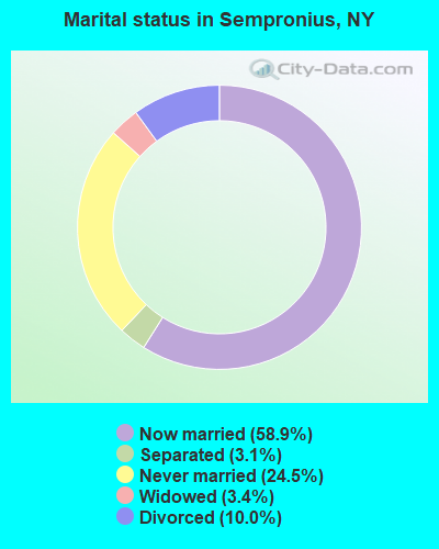
- Never married: 24.5%
- Now married: 58.9%
- Separated: 3.1%
- Widowed: 3.4%
- Divorced: 10.0%
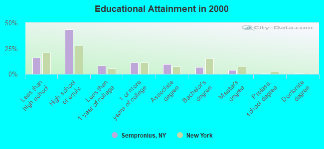
For population 25 years and over in Sempronius:
- High school or higher: 84.0%
- Bachelor's degree or higher: 11.2%
- Graduate or professional degree: 4.6%
- Unemployed: 7.5%
- Mean travel time to work (commute): 25.3 minutes
| Here: | 9.1 |
| New York average: | 14.2 |
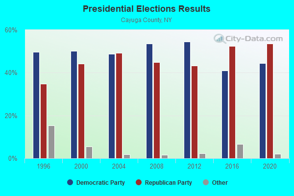
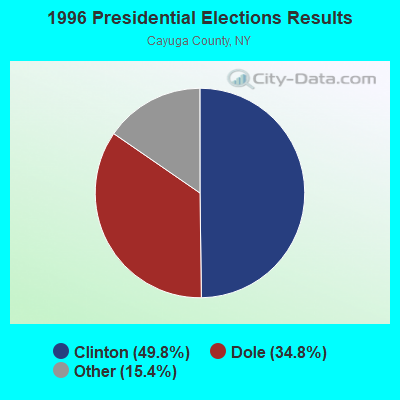
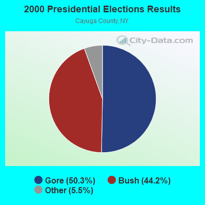
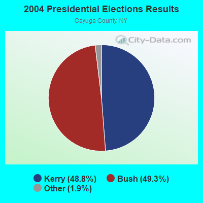
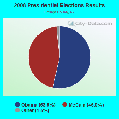
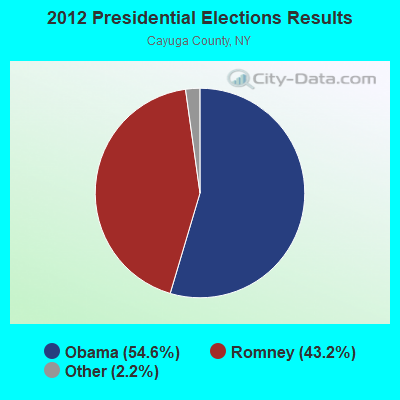
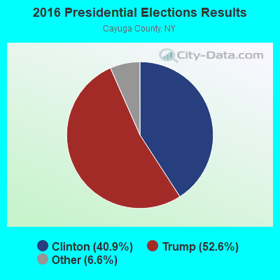
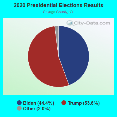
Graphs represent county-level data. Detailed 2008 Election Results
Religion statistics for Sempronius, NY (based on Cayuga County data)
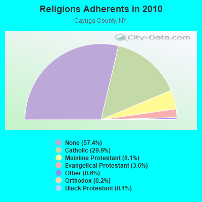
| Religion | Adherents | Congregations |
|---|---|---|
| Catholic | 23,937 | 10 |
| Mainline Protestant | 6,462 | 38 |
| Evangelical Protestant | 2,886 | 31 |
| Other | 502 | 5 |
| Orthodox | 150 | 1 |
| Black Protestant | 119 | 1 |
| None | 45,970 | - |
Food Environment Statistics:
| This county: | 2.12 / 10,000 pop. |
| State: | 4.13 / 10,000 pop. |
| Cayuga County: | 0.25 / 10,000 pop. |
| State: | 0.06 / 10,000 pop. |
| Cayuga County: | 0.50 / 10,000 pop. |
| State: | 0.92 / 10,000 pop. |
| Cayuga County: | 3.50 / 10,000 pop. |
| New York: | 1.68 / 10,000 pop. |
| Here: | 7.25 / 10,000 pop. |
| New York: | 8.82 / 10,000 pop. |
| Cayuga County: | 8.0% |
| State: | 8.2% |
| Cayuga County: | 25.6% |
| New York: | 23.8% |
| Cayuga County: | 12.2% |
| State: | 15.6% |
Strongest AM radio stations in Sempronius:
- WSYR (570 AM; 5 kW; SYRACUSE, NY; Owner: CLEAR CHANNEL BROADCASTING LICENSES, INC.)
- WHCU (870 AM; 5 kW; ITHACA, NY; Owner: EAGLE BROADCASTING COMPANY, INC.)
- WHEN (620 AM; 5 kW; SYRACUSE, NY; Owner: CLEAR CHANNEL BROADCASTING LICENSES, INC.)
- WPIE (1160 AM; 5 kW; TRUMANSBURG, NY; Owner: PEMBROOK PINES ITHACA LTD. N.A.)
- WHAM (1180 AM; 50 kW; ROCHESTER, NY; Owner: CITICASTERS LICENSES, L.P.)
- WNSS (1260 AM; 5 kW; SYRACUSE, NY; Owner: CITADEL BROADCASTING COMPANY)
- WTKO (1470 AM; 5 kW; ITHACA, NY; Owner: EAGLE II BROADCASTING CORPORATION)
- WSIV (1540 AM; 2 kW; E. SYRACUSE, NY; Owner: CRAM COMMUNICATIONS LLC)
- WKRT (920 AM; 1 kW; CORTLAND, NY; Owner: CITADEL BROADCASTING COMPANY)
- WGY (810 AM; 50 kW; SCHENECTADY, NY; Owner: CLEAR CHANNEL BROADCASTING LICENSES, INC.)
- WDCW (1390 AM; 5 kW; SYRACUSE, NY; Owner: KIMTRON, INC.)
- WINR (680 AM; 5 kW; BINGHAMTON, NY; Owner: CLEVELAND RADIO LICENSES, LLC)
- WNBF (1290 AM; 9 kW; BINGHAMTON, NY; Owner: CITADEL BROADCASTING COMPANY)
Strongest FM radio stations in Sempronius:
- WPHR (106.9 FM; AUBURN, NY; Owner: CLEAR CHANNEL BROADCASTING LICENSES, INC.)
- WXHC (101.5 FM; HOMER, NY; Owner: EVES BROADCASTING, INC.)
- WIII (99.9 FM; CORTLAND, NY; Owner: CITADEL BROADCASTING COMPANY)
- W251AK (98.1 FM; NEDROW, NY; Owner: PATHWAY COMMUNITY RADIO, INC.)
- WYXL (97.3 FM; ITHACA, NY; Owner: EAGLE BROADCASTING COMPANY)
- WMHR (102.9 FM; SYRACUSE, NY; Owner: MARS HILL BROADCASTING CO., INC.)
- WYYY (94.5 FM; SYRACUSE, NY; Owner: CLEAR CHANNEL BROADCASTING LICENSES, INC.)
- WCNY-FM (91.3 FM; SYRACUSE, NY; Owner: THE PUB. B/C COUNC. OF CEN. NY, INC.)
- WNTQ (93.1 FM; SYRACUSE, NY; Owner: CITADEL BROADCASTING COMPANY)
- WQNY (103.7 FM; ITHACA, NY; Owner: EAGLE II BROADCASTING CORPORATION)
- W278AH (103.5 FM; SYRACUSE, JAMESVILLE, NY; Owner: CALVARY CHAPEL OF THE FINGER LAKES, INC.)
- WWHT (107.9 FM; SYRACUSE, NY; Owner: CLEAR CHANNEL BROADCASTING LICENSES, INC.)
- WSQG-FM (90.9 FM; ITHACA, NY; Owner: WSKG PUBLIC TELECOMM. COUNCIL)
- WWDG (105.1 FM; DERUYTER, NY; Owner: CLEAR CHANNEL BROADCASTING LICENSES, INC.)
- WHWK (98.1 FM; BINGHAMTON, NY; Owner: CITADEL BROADCASTING COMPANY)
- WNYR-FM (98.5 FM; WATERLOO, NY; Owner: LAKE COUNTRY BROADCASTING, INC.)
- WFLK (101.7 FM; GENEVA, NY; Owner: MB COMMUNICATIONS, INC.)
- WLLW (99.3 FM; SENECA FALLS, NY; Owner: AUBURN BROADCASTING, INC.)
- WLTI (105.9 FM; SYRACUSE, NY; Owner: CITADEL BROADCASTING COMPANY)
- WVBR-FM (93.5 FM; ITHACA, NY; Owner: CORNELL RADIO GUILD, INC.)
TV broadcast stations around Sempronius:
- WSYT (Channel 68; SYRACUSE, NY; Owner: WSYT LICENSEE L.P.)
- WCNY-TV (Channel 24; SYRACUSE, NY; Owner: PUBLIC BROADCASTING COUNCIL OF CENTRAL NEW YORK)
- WSTM-TV (Channel 3; SYRACUSE, NY; Owner: WSTM LICENSE SUBSIDIARY, INC.)
- WIXT-TV (Channel 9; SYRACUSE, NY; Owner: CENTRAL NY NEWS, INC.)
- WNYS-TV (Channel 43; SYRACUSE, NY; Owner: RKM MEDIA, INC.)
- WTVH (Channel 5; SYRACUSE, NY; Owner: WTVH LICENSE, INC.)
- WSPX-TV (Channel 56; SYRACUSE, NY; Owner: PAXSON SYRACUSE LICENSE, INC.)
- W11BP (Channel 11; SYRACUSE, ETC., NY; Owner: RENARD COMMUNICATIONS CORP.)
- W51BA (Channel 51; SYRACUSE, NY; Owner: RENARD COMMUNICATIONS CORP.)
- WTVU-LP (Channel 22; SYRACUSE, NY; Owner: RENARD COMMUNICATIONS CORP.)
- WOBX-LP (Channel 35; SYRACUSE, NY; Owner: METRO TV, INC.)
- WBLZ-LP (Channel 13; SYRACUSE, NY; Owner: RENARD COMMUNICATIONS CORP.)
- WMBO-LP (Channel 60; SYRACUSE, ETC., NY; Owner: METRO TV, INC.)
- WSTQ-LP (Channel 14; SYRACUSE, NY; Owner: FEDERAL BROADCASTING COMPANY)
- WNDR-LP (Channel 18; SYRACUSE, NY; Owner: METRO TV, INC.)
- W20BT (Channel 20; ITHACA, NY; Owner: NATIONAL MINORITY T.V., INC.)
- W48AO (Channel 48; AUBURN, NY; Owner: SONNY PERSAD)
- W30AJ (Channel 30; SYRACUSE, NY; Owner: JOHN MESTER INCOME FAMILY TRUST)
- W40BJ (Channel 40; DEWITT, NY; Owner: RENARD COMMUNICATIONS CORP.)
- W16AX (Channel 16; ITHACA, NY; Owner: WSYT LICENSEE L.P.)
- W38CY (Channel 38; SYRACUSE, NY; Owner: NATIONAL MINORITY T.V., INC.)
- W54AK (Channel 54; AUBURN, NY; Owner: SONNY PERSAD)
- National Bridge Inventory (NBI) Statistics
- 1Number of bridges
- 3ft / 0.9mTotal length
- $200,000Total costs
- 163Total average daily traffic
- 9Total average daily truck traffic
- 228Total future (year 2038) average daily traffic
FCC Registered Cell Phone Towers:
1- Reynolds Rd. (Lat: 42.748417 Lon: -76.335111), Type: Gtower, Structure height: 67.7 m, Overall height: 69.2 m, Call Sign: KNKN827
Assigned Frequencies: 869.040 MHz, 869.040 MHz, 869.040 MHz, 824.040 MHz, 824.040 MHz, 824.040 MHz, 890.010 MHz, 890.010 MHz, 890.010 MHz, 845.010 MHz, 845.010 MHz, 845.010 MHzGrant Date: 09/08/2021, Expiration Date: 10/01/2031, Certifier: David C JatlowRegistrant: At&t Services, Inc., 208 S Akard St, 20f, Dallas, TX 75202, Phone: (855) 699-7073, Email:
FCC Registered Antenna Towers:
4- CARISSA L BICK, Reynolds Rd. (272647) (Lat: 42.748417 Lon: -76.335111), Type: 69.2, Overall height: 67.7 m, Registrant: American Towers, Inc., Atcfaa-Fccnortheast@americantower.Com, , Bosto-n, Phone: (617) 585-7600
- CARISSA L BICK, Reynolds Rd. (272647) (Lat: 42.748417 Lon: -76.335111), Type: 69.2, Overall height: 67.7 m, Registrant: American Towers, Inc., Atcfaa-Fccnortheast@americantower.Com, , Bosto-n, Phone: (617) 585-7600
- CARISSA L BICK, Reynolds Rd. (272647) (Lat: 42.748417 Lon: -76.335111), Type: 69.2, Overall height: 67.7 m, Registrant: American Towers, Inc., Atcfaa-Fccnortheast@americantower.Com, , Wobur-n, Phone: (617) 585-7614
- Bridget Carter, Reynolds Rd. (272647) (Lat: 42.748417 Lon: -76.335111), Type: 69.2, Structure height: 36011 m, Overall height: 67.7 m, Registrant: American Towers, Inc., Atcfaa-Fccnortheast@americantower.Com, , Wobur-n, Phone: (617) 585-7614
FCC Registered Broadcast Land Mobile Towers:
3- Rt 41a (Lat: 42.729500 Lon: -76.313556), Call Sign: KZR650, Licensee ID: L00016795,
Assigned Frequencies: 46.1000 MHz, Grant Date: 08/25/2004, Expiration Date: 11/07/2014, Cancellation Date: 01/10/2015, Registrant: Cayuga County 911 Communications, 7445 County House Rd, Auburn, NY 13021-8297, Phone: (315) 253-1191, Fax: (315) 253-1192, Email:
- Curtin Rd And State Rt 41a (Lat: 42.758667 Lon: -76.331333), Type: Tower, Structure height: 57 m, Overall height: 59 m, Call Sign: WPMW718,
Assigned Frequencies: 151.280 MHz, 159.435 MHz, Grant Date: 12/03/2013, Expiration Date: 02/26/2024, Cancellation Date: 03/24/2015, Certifier: John M Kenty, Registrant: Fcca, 122 Baltimore St, Gettysburg, PA 17325, Phone: (717) 338-1505, Fax: (717) 334-5656, Email:
- Coen Curtin Rd Rt 41a (Lat: 42.758611 Lon: -76.331667), Type: Tower, Structure height: 58 m, Call Sign: WPSE540, Licensee ID: L00582241,
Assigned Frequencies: 151.565 MHz, Grant Date: 03/19/2011, Expiration Date: 03/28/2021, Cancellation Date: 06/05/2021, Certifier: Signature On File, Registrant: C Com Of Central New York, 1741 Clark St Rd, Aubuen, NY 13021, Phone: (315) 255-1641, Fax: (315) 255-0814
FCC Registered Microwave Towers:
5- Sempronius TP1A, Lat: 42.713139 Lon: -76.326972, Type: Pole, Structure height: 21 m, Overall height: 22 m, Call Sign: WQJU320,
Assigned Frequencies: 3650.00 MHz, Grant Date: 01/06/2009, Expiration Date: 01/06/2019, Cancellation Date: 03/09/2019, Certifier: Joseph M Lalley, Registrant: Clarity Connect, Inc., 200 Pleasant Grove Road, Ithaca, NY 14850, Phone: (607) 227-5500, Email:
- Sempronius TP2A, Lat: 42.774250 Lon: -76.336333, Type: Pole, Structure height: 21 m, Overall height: 22 m, Call Sign: WQJU320,
Assigned Frequencies: 3650.00 MHz, Grant Date: 01/06/2009, Expiration Date: 01/06/2019, Cancellation Date: 03/09/2019, Certifier: Joseph M Lalley, Registrant: Clarity Connect, Inc., 200 Pleasant Grove Road, Ithaca, NY 14850, Phone: (607) 227-5500, Email:
- Sempronius TP4D, Lat: 42.729861 Lon: -76.360556, Type: Pole, Structure height: 21 m, Overall height: 22 m, Call Sign: WQJU320,
Assigned Frequencies: 3650.00 MHz, Grant Date: 01/06/2009, Expiration Date: 01/06/2019, Cancellation Date: 03/09/2019, Certifier: Joseph M Lalley, Registrant: Clarity Connect, Inc., 200 Pleasant Grove Road, Ithaca, NY 14850, Phone: (607) 227-5500, Email:
- Sempronius TP5A, Lat: 42.723722 Lon: -76.278917, Type: Pole, Structure height: 21 m, Overall height: 22 m, Call Sign: WQJU320,
Assigned Frequencies: 3650.00 MHz, Grant Date: 01/06/2009, Expiration Date: 01/06/2019, Cancellation Date: 03/09/2019, Certifier: Joseph M Lalley, Registrant: Clarity Connect, Inc., 200 Pleasant Grove Road, Ithaca, NY 14850, Phone: (607) 227-5500, Email:
- SEMPRONIUS, 1.5 Miles Sw Of (Lat: 42.748389 Lon: -76.334917), Overall height: 69.5 m, Call Sign: WGW486,
Assigned Frequencies: 3710.00 MHz, 5974.85 MHz, 5945.20 MHz, 3730.00 MHz, 3790.00 MHz, 6034.15 MHz, 6004.50 MHz, 3810.00 MHz, 3870.00 MHz, 6063.80 MHz... (+16 more), Grant Date: 12/19/2000, Expiration Date: 02/01/2011, Cancellation Date: 10/01/2008, Certifier: Karen Zacharia, Registrant: Mci Communications Services, Inc., 2400 N. Glenville Drive, Dept/Loc 71216/107, Richardson, TX 75082, Phone: (972) 729-6406, Fax: (972) 729-2690, Email:
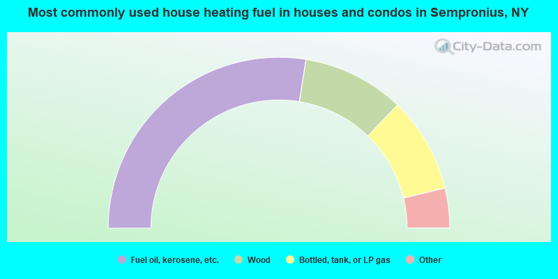
- 55.1%Fuel oil, kerosene, etc.
- 19.3%Wood
- 18.1%Bottled, tank, or LP gas
- 3.9%Electricity
- 2.8%Coal or coke
- 0.8%Utility gas
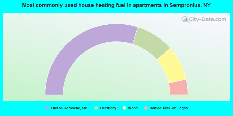
- 59.6%Fuel oil, kerosene, etc.
- 17.5%Electricity
- 15.8%Wood
- 7.0%Bottled, tank, or LP gas
Sempronius compared to New York state average:
- Median house value significantly below state average.
- Unemployed percentage below state average.
- Black race population percentage significantly below state average.
- Hispanic race population percentage significantly below state average.
- Foreign-born population percentage significantly below state average.
- Renting percentage significantly below state average.
- Length of stay since moving in significantly above state average.
- Number of rooms per house significantly below state average.
- House age significantly below state average.
- Number of college students below state average.
- Percentage of population with a bachelor's degree or higher significantly below state average.