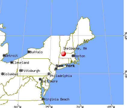
Shelburne, Massachusetts
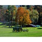
Shelburne: Autumn scene in Shelburne, MA
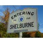
Shelburne: Shelburne, MA
Shelburne: Off Rt. 2, Shelburne, MA
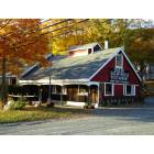
Shelburne: Famous Gould's Sugar House - Shelburne, MA
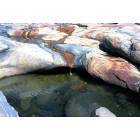
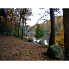
Shelburne: Shelburne Falls Glacial Pot Holes
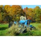
Shelburne: Countryside - Shelburne, MA
- add
your
Submit your own pictures of this town and show them to the world
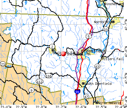
- OSM Map
- General Map
- Google Map
- MSN Map
Population change since 2000: -8.0%
 |
| Males: 933 | |
| Females: 960 |
| Median resident age: | 48.2 years |
| Massachusetts median age: | 39.2 years |
Zip codes: 01370.
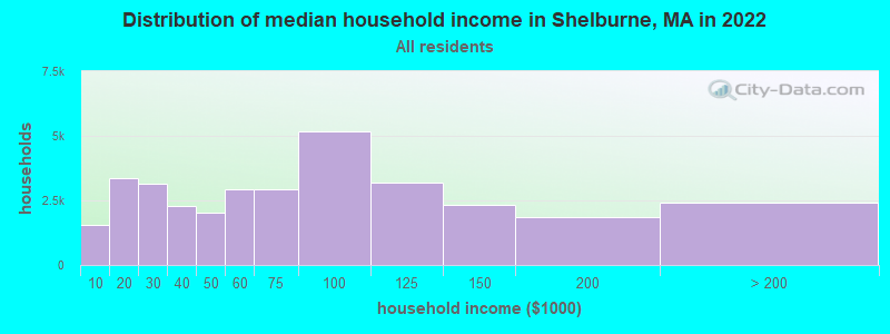
| Shelburne: | $72,524 |
| MA: | $94,488 |
Estimated per capita income in 2022: $37,038 (it was $20,329 in 2000)
Shelburne town income, earnings, and wages data
Estimated median house or condo value in 2022: $352,149 (it was $141,700 in 2000)
| Shelburne: | $352,149 |
| MA: | $534,700 |
Mean prices in 2022: all housing units: $313,377; detached houses: $324,224; townhouses or other attached units: $284,225; in 2-unit structures: $287,978; in 3-to-4-unit structures: $183,938; in 5-or-more-unit structures: $249,762; mobile homes: $62,200
Detailed information about poverty and poor residents in Shelburne, MA
Compare current foreclosures near Shelburne, MA:
| Photo | Address | Area | Beds / Baths | Price | Details |
|---|---|---|---|---|---|

|
#1
Lampblack Rd
Greenfield, MA 01301
|
2,078 sq. feet
|
1 baths 3 beds |
$379,900
|
show details |

|
#2
Hope St
Greenfield, MA 01301
|
2,013 sq. feet
|
2 baths 6 beds |
show details | |

|
#3
West St
Greenfield, MA 01301
|
1,858 sq. feet
|
2 baths 3 beds |
show details | |

|
#4
Walnut St
Northfield, MA 01354
|
1,704 sq. feet
|
2 baths 4 beds |
show details | |

|
#5
South St
Ashfield, MA 01330
|
4,386 sq. feet
|
3 baths 6 beds |
show details | |

|
#6
Chapman St
Greenfield, MA 01301
|
- sq. feet
|
1 baths 3 beds |
show details | |

|
#7
Church Rd
Drury, MA 01343
|
2,560 sq. feet
|
2 baths 4 beds |
show details | |

|
#8
Log Plain Rd
Greenfield, MA 01301
|
960 sq. feet
|
1 baths 3 beds |
show details | |

|
#9
Loop Rd
Savoy, MA 01256
|
1,040 sq. feet
|
1 baths 3 beds |
show details | |

|
#10
N Main St
South Deerfield, MA 01373
|
2,143 sq. feet
|
1 baths 5 beds |
show details |
| Photo | Address | Area | Beds / Baths | Price | Details |
|---|---|---|---|---|---|

|
#11
Braeburn Rd
South Deerfield, MA 01373
|
1,661 sq. feet
|
1 baths 3 beds |
show details | |

|
#12
Pratt St
Erving, MA 01344
|
3,000 sq. feet
|
4 baths 7 beds |
show details | |

|
#13
Franklin St
Turners Falls, MA 01349
|
2,224 sq. feet
|
2 baths 5 beds |
show details | |

|
#14
Number 9 Rd
Charlemont, MA 01339
|
2,058 sq. feet
|
2 baths 3 beds |
show details | |

|
#15
Boyle Rd
Northfield, MA 01354
|
1,500 sq. feet
|
2 baths 3 beds |
show details | |

|
#16
Central St
Turners Falls, MA 01376
|
1,506 sq. feet
|
1 baths 3 beds |
show details | |

|
#17
Ledgewood Dr
Sunderland, MA 01375
|
2,119 sq. feet
|
2 baths 3 beds |
show details | |

|
#18
Tea St
Charlemont, MA 01339
|
2,829 sq. feet
|
2 baths 6 beds |
show details | |

|
#19
Sunderland Rd
South Deerfield, MA 01373
|
1,385 sq. feet
|
1 baths 3 beds |
show details | |

|
#20
Legate Hill Rd
Charlemont, MA 01339
|
2,016 sq. feet
|
2 baths 3 beds |
show details |
| Photo | Address | Area | Beds / Baths | Price | Details |
|---|---|---|---|---|---|

|
#21
Legate Hill Rd
Charlemont, MA 01339
|
2,016 sq. feet
|
2 baths 3 beds |
show details | |

|
#22
Main St
Northfield, MA 01360
|
6,076 sq. feet
|
2 baths 9 beds |
show details | |

|
#23
Plumtree Rd
Sunderland, MA 01375
|
1,536 sq. feet
|
2 baths 2 beds |
show details | |

|
#24
Long Plain Rd
South Deerfield, MA 01373
|
1,909 sq. feet
|
2 baths 4 beds |
show details | |

|
#25
Grove St
Turners Falls, MA 01376
|
2,273 sq. feet
|
1 baths 4 beds |
show details | |

|
#26
W Hawley Rd
Charlemont, MA 01339
|
1,440 sq. feet
|
1 baths 2 beds |
show details | |

|
#27
New Plain Rd
Northfield, MA 01360
|
2,370 sq. feet
|
2 baths 2 beds |
show details | |

|
#28
Chestnut St
West Hatfield, MA 01088
|
1,248 sq. feet
|
1 baths 3 beds |
show details | |

|
#29
Elm St
Greenfield, MA 01301
|
1,160 sq. feet
|
1 baths 3 beds |
show details | |

|
#30
Phillips St
Greenfield, MA 01301
|
1,904 sq. feet
|
1 baths 3 beds |
show details |
| Photo | Address | Area | Beds / Baths | Price | Details |
|---|---|---|---|---|---|

|
#31
Chapman St
Greenfield, MA 01301
|
1,472 sq. feet
|
1 baths 2 beds |
show details | |

|
#32
Garfield St
Greenfield, MA 01301
|
2,260 sq. feet
|
2 baths 4 beds |
show details | |

|
#33
Forest Ave
Greenfield, MA 01301
|
1,764 sq. feet
|
1 baths 4 beds |
show details | |

|
#34
Hope St
Greenfield, MA 01301
|
1,619 sq. feet
|
1 baths 3 beds |
show details | |

|
#35
Meridian St
Greenfield, MA 01301
|
768 sq. feet
|
1 baths 2 beds |
show details | |

|
#36
Bridge St # 1
Hatfield, MA 01038
|
3,300 sq. feet
|
3 baths 4 beds |
show details | |

|
#37
James St
Greenfield, MA 01301
|
2,176 sq. feet
|
2 baths 4 beds |
show details | |

|
#38
Maple St
Greenfield, MA 01301
|
1,216 sq. feet
|
1 baths 3 beds |
show details | |

|
#39
North St
Hatfield, MA 01038
|
1,900 sq. feet
|
1 baths 3 beds |
show details | |

|
#40
Sabans Rd
Conway, MA 01341
|
1,246 sq. feet
|
1 baths 3 beds |
show details |
| Photo | Address | Area | Beds / Baths | Price | Details |
|---|---|---|---|---|---|

|
#41
Pine St
Amherst, MA 01002
|
2,195 sq. feet
|
2 baths 4 beds |
show details | |

|
#42
French King Hwy
Greenfield, MA 01301
|
1,040 sq. feet
|
1 baths 5 beds |
show details | |

|
#43
Purington Ln
Colrain, MA 01340
|
2,030 sq. feet
|
1 baths 5 beds |
show details | |

|
#44
Dell St
Turners Falls, MA 01376
|
720 sq. feet
|
1 baths 1 beds |
show details | |

|
#45
5th St
Turners Falls, MA 01376
|
1,683 sq. feet
|
2 baths 4 beds |
show details | |

|
#46
Sand Hill Rd
Amherst, MA 01002
|
2,037 sq. feet
|
3 baths 5 beds |
show details | |

|
#47
Ridge Rd
Erving, MA 01344
|
1,232 sq. feet
|
1 baths - beds |
show details | |

|
#48
Conway St
Greenfield, MA 01301
|
5,170 sq. feet
|
4 baths - beds |
show details | |

|
#49
Thayer Corner Rd
Cummington, MA 01026
|
- sq. feet
|
- baths - beds |
show details | |

|
Check over 1 million property listings on Foreclosure.com!
|
browse all offers | |||

- 1,80795.5%White alone
- 402.1%Two or more races
- 231.2%Asian alone
- 100.5%Black alone
- 100.5%Hispanic
- 30.2%American Indian alone
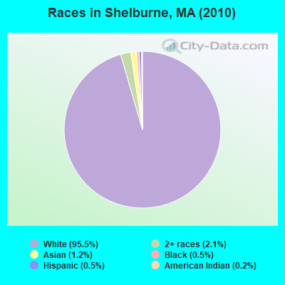
Races in Shelburne detailed stats: ancestries, foreign born residents, place of birth
Type |
2009 |
2010 |
2011 |
2012 |
2013 |
2014 |
2015 |
2016 |
2017 |
2018 |
2019 |
2020 |
2021 |
2022 |
|---|---|---|---|---|---|---|---|---|---|---|---|---|---|---|
| Murders (per 100,000) | 0 (0.0) | 0 (0.0) | 0 (0.0) | 0 (0.0) | 0 (0.0) | 0 (0.0) | 0 (0.0) | 0 (0.0) | 0 (0.0) | 0 (0.0) | 0 (0.0) | 0 (0.0) | 0 (0.0) | 0 (0.0) |
| Rapes (per 100,000) | 0 (0.0) | 0 (0.0) | 0 (0.0) | 0 (0.0) | 0 (0.0) | 0 (0.0) | 0 (0.0) | 1 (54.4) | 0 (0.0) | 0 (0.0) | 0 (0.0) | 0 (0.0) | 0 (0.0) | 0 (0.0) |
| Robberies (per 100,000) | 0 (0.0) | 0 (0.0) | 0 (0.0) | 0 (0.0) | 1 (52.6) | 0 (0.0) | 0 (0.0) | 0 (0.0) | 0 (0.0) | 0 (0.0) | 0 (0.0) | 0 (0.0) | 0 (0.0) | 0 (0.0) |
| Assaults (per 100,000) | 4 (194.6) | 0 (0.0) | 0 (0.0) | 1 (52.2) | 0 (0.0) | 0 (0.0) | 0 (0.0) | 0 (0.0) | 0 (0.0) | 0 (0.0) | 2 (107.8) | 3 (163.9) | 0 (0.0) | 0 (0.0) |
| Burglaries (per 100,000) | 1 (48.6) | 7 (369.8) | 4 (210.0) | 6 (313.3) | 1 (52.6) | 5 (264.0) | 2 (106.3) | 4 (217.5) | 5 (273.4) | 5 (271.4) | 3 (161.6) | 3 (163.9) | 0 (0.0) | 3 (158.6) |
| Thefts (per 100,000) | 14 (680.9) | 8 (422.6) | 7 (367.5) | 10 (522.2) | 6 (315.8) | 6 (316.8) | 15 (797.4) | 5 (271.9) | 9 (492.1) | 12 (651.5) | 7 (377.2) | 6 (327.9) | 5 (272.6) | 6 (317.3) |
| Auto thefts (per 100,000) | 2 (97.3) | 2 (105.7) | 0 (0.0) | 0 (0.0) | 1 (52.6) | 0 (0.0) | 0 (0.0) | 0 (0.0) | 2 (109.3) | 1 (54.3) | 0 (0.0) | 0 (0.0) | 0 (0.0) | 1 (52.9) |
| Arson (per 100,000) | 0 (0.0) | 0 (0.0) | 0 (0.0) | 0 (0.0) | 0 (0.0) | 0 (0.0) | 0 (0.0) | 0 (0.0) | 0 (0.0) | 0 (0.0) | 0 (0.0) | 0 (0.0) | 0 (0.0) | 1 (52.9) |
| City-Data.com crime index | 77.3 | 51.2 | 29.4 | 53.3 | 36.3 | 31.2 | 39.3 | 69.6 | 47.6 | 49.4 | 48.0 | 57.4 | 10.9 | 28.0 |
The City-Data.com crime index weighs serious crimes and violent crimes more heavily. Higher means more crime, U.S. average is 246.1. It adjusts for the number of visitors and daily workers commuting into cities.
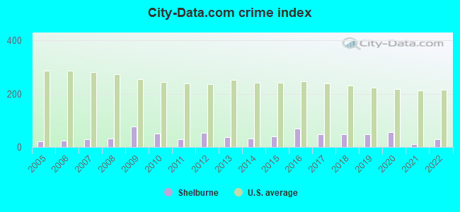
Crime rate in Shelburne detailed stats: murders, rapes, robberies, assaults, burglaries, thefts, arson
Full-time law enforcement employees in 2021, including police officers: 3 (3 officers - 3 male; 0 female).
| Officers per 1,000 residents here: | 1.64 |
| Massachusetts average: | 2.53 |
 Recent articles from our blog. Our writers, many of them Ph.D. graduates or candidates, create easy-to-read articles on a wide variety of topics.

 | Opinions on Northfield, Shelburne Falls (14 replies) |
| "All-Inclusive Boston" campaiagn (582 replies) |
| Is it possible to escape hunters, ATVs and noise in a rural area? (278 replies) |
| Catskills Like Towns in Mass? (52 replies) |
| Town in Massachusetts You’d Least Like To Live In? (179 replies) |
| Amtrak and MassDOT piloting new Valley Flyer service in Western Mass (248 replies) |
Latest news from Shelburne, MA collected exclusively by city-data.com from local newspapers, TV, and radio stations
Ancestries: English (24.5%), Irish (17.2%), German (11.3%), Polish (8.2%), Italian (7.2%), French (6.4%).
Current Local Time: EST time zone
Incorporated in 1775
Elevation: 560 feet
Land area: 23.3 square miles.
Population density: 81 people per square mile (very low).
85 residents are foreign born (2.0% Europe, 1.1% North America, 1.0% Asia).
| This town: | 4.1% |
| Massachusetts: | 12.2% |
| Shelburne town: | 1.2% ($1,717) |
| Massachusetts: | 1.3% ($2,336) |
Nearest city with pop. 50,000+: Chicopee, MA  (30.4 miles , pop. 54,653).
Nearest city with pop. 200,000+: Boston, MA (84.0 miles , pop. 589,141).
Nearest city with pop. 1,000,000+: Bronx, NY (136.0 miles , pop. 1,332,650).
Nearest cities:
), ), Latitude: 42.60 N, Longitude: 72.69 W
Area code commonly used in this area: 413

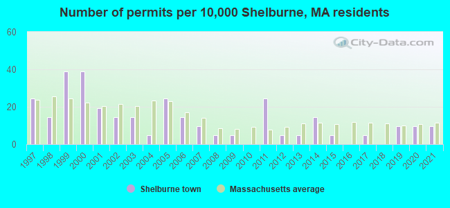
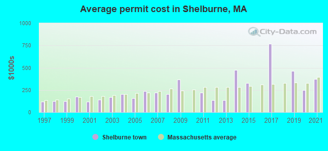
Single-family new house construction building permits:
- 2021: 2 buildings, average cost: $375,000
- 2020: 2 buildings, average cost: $250,000
- 2019: 2 buildings, average cost: $461,000
- 2017: 1 building, cost: $770,000
- 2015: 1 building, cost: $326,400
- 2014: 3 buildings, average cost: $472,300
- 2013: 1 building, cost: $135,000
- 2012: 1 building, cost: $137,500
- 2011: 5 buildings, average cost: $218,500
- 2009: 1 building, cost: $365,400
- 2008: 1 building, cost: $202,700
- 2007: 2 buildings, average cost: $220,600
- 2006: 3 buildings, average cost: $236,300
- 2005: 5 buildings, average cost: $159,300
- 2004: 1 building, cost: $202,300
- 2003: 3 buildings, average cost: $166,600
- 2002: 3 buildings, average cost: $143,000
- 2001: 4 buildings, average cost: $121,300
- 2000: 8 buildings, average cost: $172,500
- 1999: 8 buildings, average cost: $122,900
- 1998: 3 buildings, average cost: $122,000
- 1997: 5 buildings, average cost: $121,200
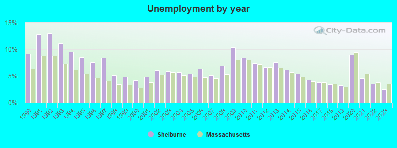
| Here: | 2.5% |
| Massachusetts: | 3.5% |
- Educational services (18.8%)
- Health care (10.8%)
- Construction (5.5%)
- Public administration (5.5%)
- Used merchandise, gift, novelty, souvenir, other miscellaneous stores (4.8%)
- Metal & metal products (4.1%)
- Accommodation & food services (3.8%)
- Educational services (14.8%)
- Construction (10.4%)
- Metal & metal products (6.1%)
- Public administration (5.5%)
- Used merchandise, gift, novelty, souvenir, other miscellaneous stores (4.6%)
- Health care (4.5%)
- Arts, entertainment, recreation (4.3%)
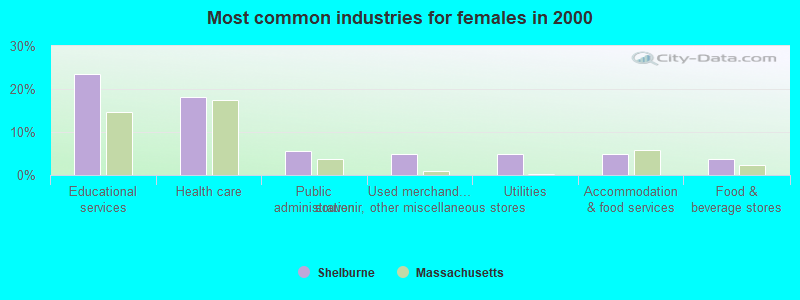
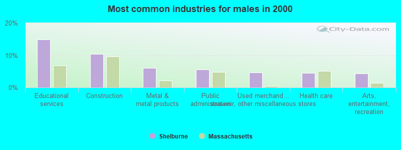
- Educational services (23.4%)
- Health care (18.1%)
- Public administration (5.5%)
- Used merchandise, gift, novelty, souvenir, other miscellaneous stores (4.9%)
- Utilities (4.9%)
- Accommodation & food services (4.9%)
- Food & beverage stores (3.7%)
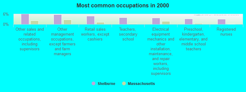
- Other sales and related occupations, including supervisors (5.9%)
- Other management occupations, except farmers and farm managers (5.7%)
- Retail sales workers, except cashiers (5.0%)
- Teachers, secondary school (4.0%)
- Electrical equipment mechanics and other installation, maintenance, and repair workers, including supervisors (3.8%)
- Preschool, kindergarten, elementary, and middle school teachers (3.2%)
- Registered nurses (3.1%)
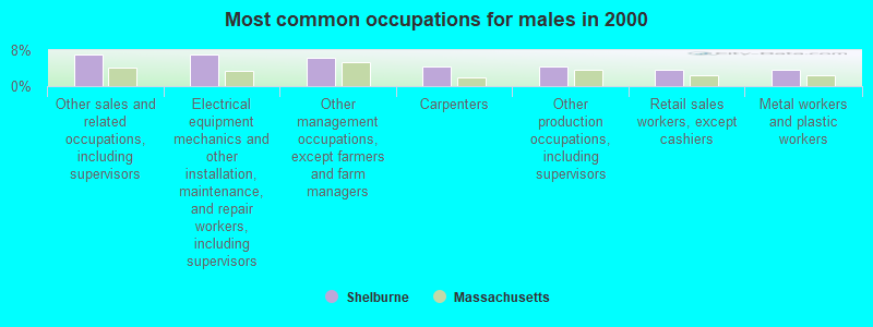
- Other sales and related occupations, including supervisors (7.1%)
- Electrical equipment mechanics and other installation, maintenance, and repair workers, including supervisors (7.1%)
- Other management occupations, except farmers and farm managers (6.2%)
- Carpenters (4.5%)
- Other production occupations, including supervisors (4.3%)
- Retail sales workers, except cashiers (3.8%)
- Metal workers and plastic workers (3.8%)
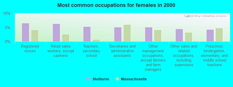
- Registered nurses (6.6%)
- Retail sales workers, except cashiers (6.4%)
- Teachers, secondary school (5.3%)
- Secretaries and administrative assistants (5.1%)
- Other management occupations, except farmers and farm managers (5.1%)
- Other sales and related occupations, including supervisors (4.5%)
- Preschool, kindergarten, elementary, and middle school teachers (4.3%)
Average climate in Shelburne, Massachusetts
Based on data reported by over 4,000 weather stations


(lower is better)
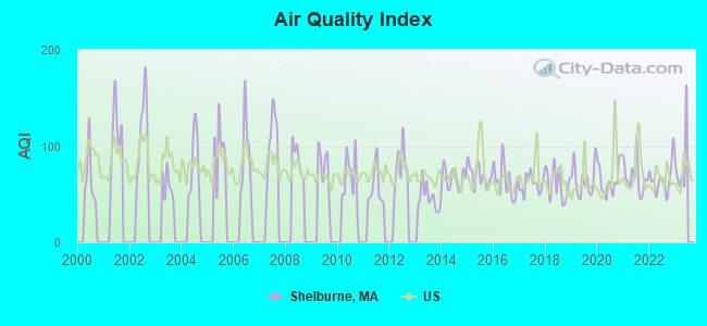
Air Quality Index (AQI) level in 2022 was 65.9. This is about average.
| City: | 65.9 |
| U.S.: | 72.6 |
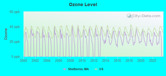
Ozone [ppb] level in 2022 was 23.8. This is better than average. Closest monitor was 4.7 miles away from the city center.
| City: | 23.8 |
| U.S.: | 33.3 |
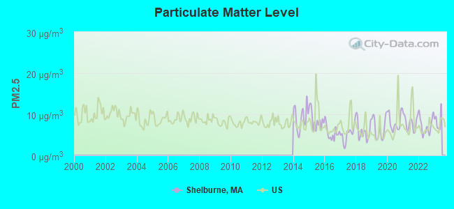
Particulate Matter (PM2.5) [µg/m3] level in 2022 was 7.23. This is about average. Closest monitor was 4.7 miles away from the city center.
| City: | 7.23 |
| U.S.: | 8.11 |
Tornado activity:
Shelburne-area historical tornado activity is slightly above Massachusetts state average. It is 15% smaller than the overall U.S. average.
On 6/9/1953, a category F4 (max. wind speeds 207-260 mph) tornado 28.0 miles away from the Shelburne town center killed 90 people and injured 1228 people and caused between $50,000,000 and $500,000,000 in damages.
On 10/3/1979, a category F4 tornado 38.3 miles away from the town center killed 3 people and injured 500 people and caused between $50,000,000 and $500,000,000 in damages.
Earthquake activity:
Shelburne-area historical earthquake activity is significantly above Massachusetts state average. It is 69% smaller than the overall U.S. average.On 10/7/1983 at 10:18:46, a magnitude 5.3 (5.1 MB, 5.3 LG, 5.1 ML, Class: Moderate, Intensity: VI - VII) earthquake occurred 125.1 miles away from Shelburne center
On 4/20/2002 at 10:50:47, a magnitude 5.3 (5.3 ML, Depth: 3.0 mi) earthquake occurred 141.4 miles away from Shelburne center
On 4/20/2002 at 10:50:47, a magnitude 5.2 (5.2 MB, 4.2 MS, 5.2 MW, 5.0 MW) earthquake occurred 140.1 miles away from Shelburne center
On 1/19/1982 at 00:14:42, a magnitude 4.7 (4.5 MB, 4.7 MD, 4.5 LG, Class: Light, Intensity: IV - V) earthquake occurred 82.9 miles away from Shelburne center
On 10/16/2012 at 23:12:25, a magnitude 4.7 (4.7 ML, Depth: 10.0 mi) earthquake occurred 123.6 miles away from Shelburne center
On 6/17/1991 at 08:53:16, a magnitude 4.1 (4.0 MB, 4.0 LG, Depth: 3.1 mi) earthquake occurred 101.2 miles away from the city center
Magnitude types: regional Lg-wave magnitude (LG), body-wave magnitude (MB), duration magnitude (MD), local magnitude (ML), surface-wave magnitude (MS), moment magnitude (MW)
Natural disasters:
The number of natural disasters in Franklin County (20) is greater than the US average (15).Major Disasters (Presidential) Declared: 9
Emergencies Declared: 10
Causes of natural disasters: Floods: 5, Storms: 5, Hurricanes: 4, Snowstorms: 4, Winter Storms: 3, Blizzards: 2, Snows: 2, Snowfall: 1, Tropical Storm: 1, Wind: 1, Other: 1 (Note: some incidents may be assigned to more than one category).
Hospitals and medical centers in Shelburne:
Other hospitals and medical centers near Shelburne:
- CHARLENE MANOR EXTENDED CARE FACILITY (Nursing Home, about 4 miles away; GREENFIELD, MA)
- BUCKLEY-GREENFIELD HEALTHCARE CENTER (Nursing Home, about 4 miles away; GREENFIELD, MA)
- HOSPICE OF FRANKLIN COUNTY, INC (Hospital, about 4 miles away; GREENFIELD, MA)
- FRANKLIN CENTER (Nursing Home, about 4 miles away; GREENFIELD, MA)
- HOME CARE PRN INC (Home Health Center, about 5 miles away; GREENFIELD, MA)
- GENTIVA HEALTH SERVICES (Home Health Center, about 5 miles away; GREENFIELD, MA)
- BAYSTATE FRANKLIN MEDICAL CENTER Acute Care Hospitals (about 6 miles away; GREENFIELD, MA)
Amtrak stations near Shelburne:
- 18 miles: BRATTLEBORO (VERNON RD.) . Services: enclosed waiting area, public restrooms, call for car rental service, call for taxi service.
- 19 miles: AMHERST (RAILROAD ST.) . Services: enclosed waiting area, public payphones, free short-term parking, paid long-term parking, call for car rental service, call for taxi service, public transit connection.
Operable nuclear power plant near Shelburne:
- 15 miles: Vermont Yankee in Vernon, VT.
Colleges/universities with over 2000 students nearest to Shelburne:
- University of Massachusetts-Amherst (about 18 miles; Amherst, MA; Full-time enrollment: 26,583)
- Smith College (about 20 miles; Northampton, MA; FT enrollment: 3,549)
- Mount Holyoke College (about 25 miles; South Hadley, MA; FT enrollment: 2,573)
- Williams College (about 28 miles; Williamstown, MA; FT enrollment: 2,141)
- Holyoke Community College (about 29 miles; Holyoke, MA; FT enrollment: 4,911)
- Keene State College (about 31 miles; Keene, NH; FT enrollment: 5,098)
- Westfield State University (about 34 miles; Westfield, MA; FT enrollment: 5,548)
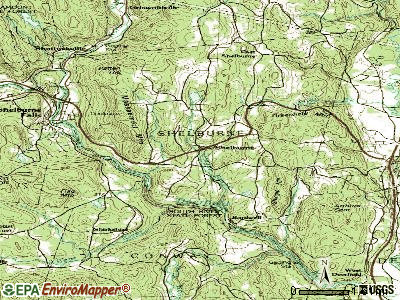
Points of interest:
Notable locations in Shelburne: Apex Orchard (A), Camp Apex (B), Springbrook Campground (C), Shelburne Fire Department Station 1 Headquarters (D), Arms Library Association Library (E). Display/hide their locations on the map
Church in Shelburne: Trinity Church (A). Display/hide its location on the map
Cemeteries: South Cemetery (1), Hawks Cemetery (2), Hill Cemetery (3), Skinner Cemetery (4), Shelburne Center Cemetery (5), Jones Cemetery (6), Arms Cemetery (7). Display/hide their locations on the map
Reservoirs: Deerfield River Reservoir (A), Number 3 Forebay Reservoir (B), Albert Davenport Pond (C). Display/hide their locations on the map
Streams, rivers, and creeks: Hawkes Brook (A), Great Brook (B), Dragon Brook (C), Bear River (D), Sluice Brook (E), Schneck Brook (F), Stewart Brook (G), North River (H). Display/hide their locations on the map
Drinking water stations with addresses in Shelburne and their reported violations in the past:
DRAGON HILL CONDOMINIUMS (Population served: 30, Groundwater):Past health violations:
- MCL, Monthly (TCR) - In SEP-2011, Contaminant: Coliform. Follow-up actions: St AO (w/o penalty) issued (OCT-05-2011)
| This town: | 2.2 people |
| Massachusetts: | 2.5 people |
| This town: | 57.1% |
| Whole state: | 63.0% |
| This town: | 9.1% |
| Whole state: | 7.0% |
Likely homosexual households (counted as self-reported same-sex unmarried-partner households)
- Lesbian couples: 0.8% of all households
- Gay men: 0.6% of all households
| This town: | 9.9% |
| Whole state: | 9.3% |
| This town: | 5.7% |
| Whole state: | 4.4% |
22 people in group homes intended for adults in 2010
75 people in nursing homes in 2000
53 people in homes or halfway houses for drug/alcohol abuse in 2000
Banks with branches in Shelburne (2011 data):
- Greenfield Savings Bank: Shelburne Falls Branch at 58 Bridge Street, branch established on 1988/06/06. Info updated 2006/10/11: Bank assets: $640.0 mil, Deposits: $458.2 mil, headquarters in Greenfield, MA, positive income, Mortgage Lending Specialization, 6 total offices, Holding Company: Gsb, Mhc
For population 15 years and over in Shelburne:
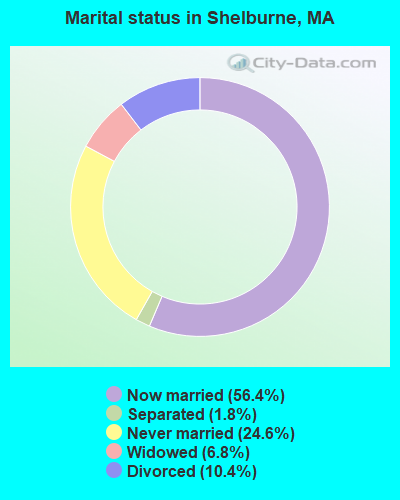
- Never married: 24.6%
- Now married: 56.4%
- Separated: 1.8%
- Widowed: 6.8%
- Divorced: 10.4%
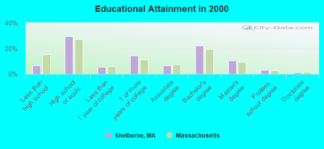
For population 25 years and over in Shelburne:
- High school or higher: 93.3%
- Bachelor's degree or higher: 37.0%
- Graduate or professional degree: 14.7%
- Unemployed: 4.6%
- Mean travel time to work (commute): 22.1 minutes
| Here: | 11.0 |
| Massachusetts average: | 13.1 |


Graphs represent county-level data. Detailed 2008 Election Results
Religion statistics for Shelburne, MA (based on Franklin County data)


| Religion | Adherents | Congregations |
|---|---|---|
| Catholic | 16,509 | 15 |
| Mainline Protestant | 4,617 | 38 |
| Evangelical Protestant | 2,079 | 20 |
| Other | 1,580 | 21 |
| None | 46,587 | - |
Food Environment Statistics:
| This county: | 3.63 / 10,000 pop. |
| Massachusetts: | 1.98 / 10,000 pop. |
| Franklin County: | 0.14 / 10,000 pop. |
| Massachusetts: | 0.05 / 10,000 pop. |
| Franklin County: | 1.67 / 10,000 pop. |
| State: | 2.22 / 10,000 pop. |
| Franklin County: | 3.21 / 10,000 pop. |
| Massachusetts: | 1.77 / 10,000 pop. |
| This county: | 8.10 / 10,000 pop. |
| Massachusetts: | 8.76 / 10,000 pop. |
| Here: | 7.5% |
| State: | 8.1% |
| Franklin County: | 22.2% |
| State: | 22.5% |
| Here: | 15.1% |
| State: | 16.5% |
Strongest AM radio stations in Shelburne:
- WIZZ (1520 AM; daytime; 10 kW; GREENFIELD, MA; Owner: P. & M. RADIO, LLC)
- WNNZ (640 AM; 50 kW; WESTFIELD, MA; Owner: CLEAR CHANNEL BROADCASTING LICENSES, INC.)
- WHMQ (1240 AM; 1 kW; GREENFIELD, MA; Owner: SAGA COMMUNICATIONS OF NEW ENGLAND, LLC)
- WCRN (830 AM; 50 kW; WORCESTER, MA; Owner: CARTER BROADCASTING CORPORATION)
- WVNE (760 AM; daytime; 25 kW; LEICESTER, MA; Owner: BLOUNT MASSCOM, INC.)
- WTIC (1080 AM; 50 kW; HARTFORD, CT; Owner: INFINITY RADIO OPERATIONS INC.)
- WGY (810 AM; 50 kW; SCHENECTADY, NY; Owner: CLEAR CHANNEL BROADCASTING LICENSES, INC.)
- WRKO (680 AM; 50 kW; BOSTON, MA; Owner: ENTERCOM BOSTON LICENSE, LLC)
- WHYN (560 AM; 5 kW; SPRINGFIELD, MA; Owner: CLEAR CHANNEL BROADCASTING LICENSES, INC.)
- WEEI (850 AM; 50 kW; BOSTON, MA; Owner: ENTERCOM BOSTON LICENSE, LLC)
- WALE (990 AM; 50 kW; GREENVILLE, RI; Owner: NORTH AMERICAN BROADCASTING CO., INC.)
- WPTR (1540 AM; 50 kW; ALBANY, NY; Owner: KIMTRON, INC.)
- WKOX (1200 AM; 50 kW; FRAMINGHAM, MA; Owner: CAPSTAR TX LIMITED PARTNERSHIP)
Strongest FM radio stations in Shelburne:
- WRSI (93.9 FM; TURNERS FALLS, MA; Owner: GREAT NORTHERN RADIO, LLC)
- WHAI (98.3 FM; GREENFIELD, MA; Owner: SAGA COMMUNICATIONS OF NEW ENGLAND, LLC)
- WPVQ (95.3 FM; GREENFIELD, MA; Owner: GREAT NORTHERN RADIO, L.L.C.)
- WAMC-FM (90.3 FM; ALBANY, NY; Owner: WAMC)
- WGAJ (91.7 FM; DEERFIELD, MA; Owner: TRUATEES OF DEERFIELD ACADEMY)
- WVAY (100.7 FM; WILMINGTON, VT; Owner: GREAT NORTHERN RADIO, L.L.C.)
- WRSY (101.5 FM; MARLBORO, VT; Owner: GREAT NORTHERN RADIO, L.L.C.)
- WFCR (88.5 FM; AMHERST, MA; Owner: UNIVERSITY OF MASSACHUSETTS)
- WEQX (102.7 FM; MANCHESTER, VT; Owner: NORTHSHIRE COMMUNICATIONS, INC.)
- WYRY (104.9 FM; HINSDALE, NH; Owner: TRI-VALLEY BROADCASTING CORPORATION)
- WJAN (95.1 FM; SUNDERLAND, VT; Owner: 6 JOHNSON ROAD LICENSES, INC.)
- WHYN-FM (93.1 FM; SPRINGFIELD, MA; Owner: CLEAR CHANNEL BROADCASTING LICENSES, INC.)
- WRNX (100.9 FM; AMHERST, MA; Owner: WESTERN MASSACHUSETTS RADIO COMPANY)
- WAMH (89.3 FM; AMHERST, MA; Owner: TRUSTEES OF AMHERST COLLEGE)
- WKVT-FM (92.7 FM; BRATTLEBORO, VT; Owner: SAGA COMMUNICATIONS OF NEW ENGLAND, LLC)
- WLZX (99.3 FM; NORTHAMPTON, MA; Owner: SAGA COMMUNICATIONS OF NEW ENGLAND, LLC)
- WOQL (98.7 FM; WINCHESTER, NH; Owner: SAGA COMMUNICATIONS OF NEW HAMPSHIRE, LLC)
- WHDQ (106.1 FM; CLAREMONT, NH; Owner: GREAT NORTHERN RADIO, L.L.C.)
- W246AM (97.1 FM; AMHERST, MA; Owner: GREAT NORTHERN RADIO, LLC)
- WCMK (91.9 FM; PUTNEY, VT; Owner: CHRISTIAN MINISTRIES INC)
TV broadcast stations around Shelburne:
- WYDN (Channel 48; WORCESTER, MA; Owner: EDUCATIONAL PUBLIC TV CORPORATION)
- W35BK (Channel 35; PLAINFIELD, MA; Owner: LYDIA SYLVANE STOCKWELL)
- National Bridge Inventory (NBI) Statistics
- 4Number of bridges
- 16ft / 4.9mTotal length
- $1,056,000Total costs
- 1,409Total average daily traffic
- 72Total average daily truck traffic
- 1,106Total future (year 2031) average daily traffic
FCC Registered Cell Phone Towers:
1- 100 Guy Manner Road (Lat: 42.571111 Lon: -72.644556), Type: Gtower, Structure height: 46.6 m, Overall height: 51.2 m, Call Sign: KNKN769
Assigned Frequencies: 880.020 MHz, 880.020 MHz, 880.020 MHz, 835.020 MHz, 835.020 MHz, 835.020 MHz, 891.510 MHz, 891.510 MHz, 891.510 MHz, 846.510 MHz, 846.510 MHz, 846.510 MHzGrant Date: 09/08/2021, Expiration Date: 10/01/2031, Certifier: Michael P GogginRegistrant: At&t Services, Inc., 208 S Akard St, 20f, Dallas, TX 75202, Phone: (855) 699-7073, Email:
FCC Registered Commercial Land Mobile Towers:
2 (See the full list of FCC Registered Commercial Land Mobile Towers in Shelburne, MA)FCC Registered Broadcast Land Mobile Towers:
9 (See the full list of FCC Registered Broadcast Land Mobile Towers)FCC Registered Microwave Towers:
12 (See the full list of FCC Registered Microwave Towers in this town)FCC Registered Paging Towers:
5 (See the full list of FCC Registered Paging Towers)FCC Registered Amateur Radio Licenses:
2- Call Sign: KA1SZD, Grant Date: 08/17/1998, Expiration Date: 08/17/2008, Cancellation Date: 08/18/2010, Registrant: Robert L Nichols, Box 152b Bardwells Ferry Rd, Shelburne, MA 01370
- Call Sign: KB2WCA, Licensee ID: L01034944, Grant Date: 10/24/2017, Expiration Date: 10/24/2027, Certifier: Alyce S Stiles, Registrant: Alyce S Stiles, 1500 B Mohawk Trail, Shelburne, MA 01370
2002 - 2018 National Fire Incident Reporting System (NFIRS) incidents
- Fire incident types reported to NFIRS in Shelburne, MA
- 5246.4%Structure Fires
- 3632.1%Outside Fires
- 1715.2%Mobile Property/Vehicle Fires
- 76.2%Other
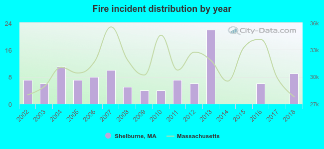 Based on the data from the years 2002 - 2018 the average number of fire incidents per year is 7. The highest number of reported fire incidents - 22 took place in 2013, and the least - 0 in 2014. The data has a rising trend.
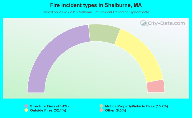 When looking into fire subcategories, the most reports belonged to: Structure Fires (46.4%), and Outside Fires (32.1%).
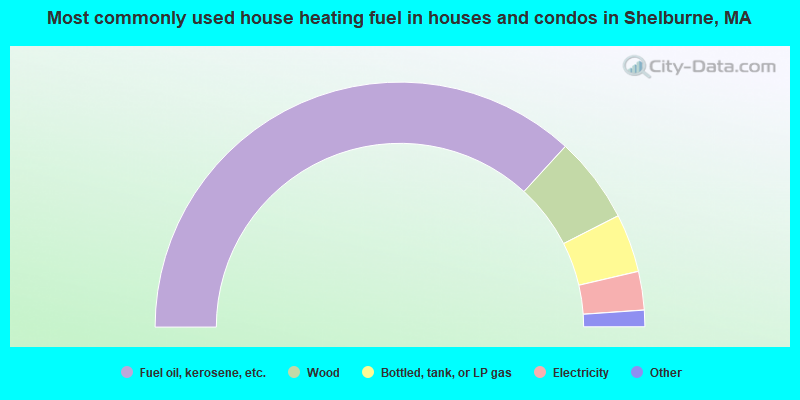
- 73.7%Fuel oil, kerosene, etc.
- 11.4%Wood
- 7.7%Bottled, tank, or LP gas
- 5.1%Electricity
- 1.6%Other fuel
- 0.6%Solar energy
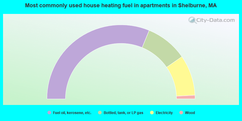
- 62.5%Fuel oil, kerosene, etc.
- 18.3%Bottled, tank, or LP gas
- 17.7%Electricity
- 1.6%Wood
Shelburne compared to Massachusetts state average:
- Median house value below state average.
- Unemployed percentage significantly below state average.
- Black race population percentage significantly below state average.
- Hispanic race population percentage significantly below state average.
- Median age significantly above state average.
- Foreign-born population percentage significantly below state average.
- Length of stay since moving in significantly above state average.
- Number of rooms per house significantly below state average.
- House age significantly below state average.
Shelburne on our top lists:
- #12 on the list of "Top 101 cities with the largest percentage of people in homes or halfway houses for drug/alcohol abuse (population 1,000+)"
- #21 on the list of "Top 101 counties with the highest percentage of residents that drank alcohol in the past 30 days"
- #65 on the list of "Top 101 counties with the lowest average weight of females"
- #84 on the list of "Top 101 counties with the lowest surface withdrawal of fresh water for public supply (pop. 50,000+)"
- #88 on the list of "Top 101 counties with the best general health status score of residents (1-5), 3 years of data"
- #92 on the list of "Top 101 counties with the highest percentage of residents that smoked 100+ cigarettes in their lives"