Siloam, Tennessee
Submit your own pictures of this place and show them to the world
- OSM Map
- General Map
- Google Map
- MSN Map

| Males: 2,137 | |
| Females: 2,070 |
| Median resident age: | 32.5 years |
| Tennessee median age: | 35.9 years |
Zip code: 37186
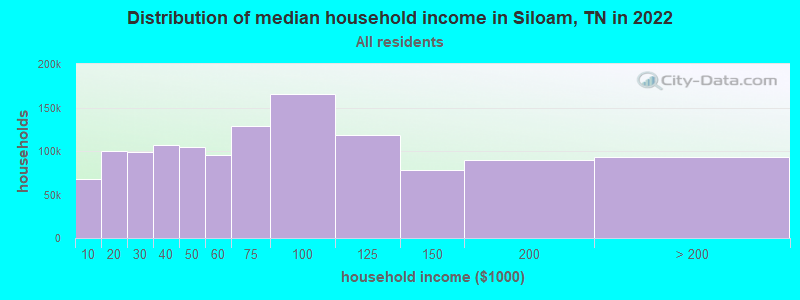
| Siloam: | $55,798 |
| TN: | $65,254 |
Estimated per capita income in 2022: $24,599 (it was $14,781 in 2000)
Siloam CCD income, earnings, and wages data
Estimated median house or condo value in 2022: $224,026 (it was $65,000 in 2000)
| Siloam: | $224,026 |
| TN: | $284,800 |
Detailed information about poverty and poor residents in Siloam, TN


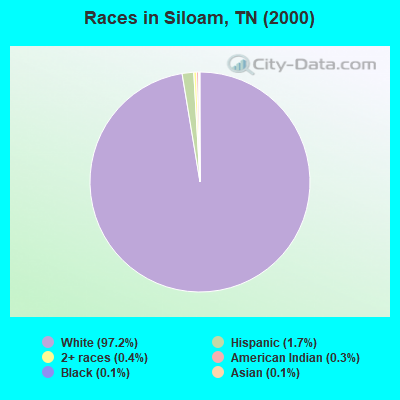
- 3,85597.2%White alone
- 691.7%Hispanic
- 150.4%Two or more races
- 130.3%American Indian alone
- 50.1%Black alone
- 50.1%Asian alone
- 30.08%Native Hawaiian and Other
Pacific Islander alone
Races in Siloam detailed stats: ancestries, foreign born residents, place of birth
 Recent articles from our blog. Our writers, many of them Ph.D. graduates or candidates, create easy-to-read articles on a wide variety of topics.
Current Local Time: CST time zone
Elevation: 897 feet
Land area: 66.3 square miles.
Population density: 63 people per square mile (very low).

| Siloam CCD: | 0.5% ($294) |
| Tennessee: | 0.8% ($715) |
Nearest city with pop. 50,000+: Nashville-Davidson, TN  (42.6 miles , pop. 545,524).
Nearest city with pop. 1,000,000+: Chicago, IL (374.8 miles , pop. 2,896,016).
Nearest cities:
), ), ), ), )Latitude: 36.55 N, Longitude: 86.17 W
Area code commonly used in this area: 615

| Here: | 2.6% |
| Tennessee: | 3.0% |
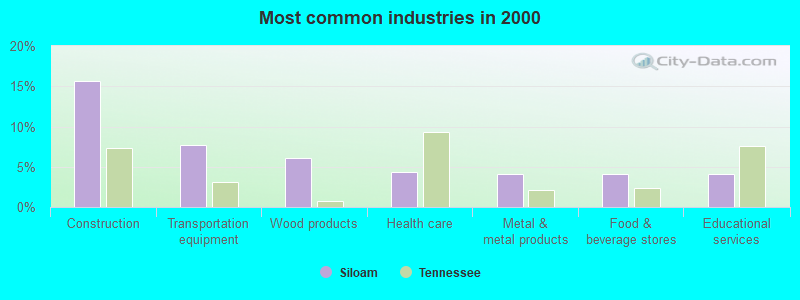
- Construction (15.7%)
- Transportation equipment (7.7%)
- Wood products (6.1%)
- Health care (4.3%)
- Metal & metal products (4.1%)
- Food & beverage stores (4.1%)
- Educational services (4.1%)
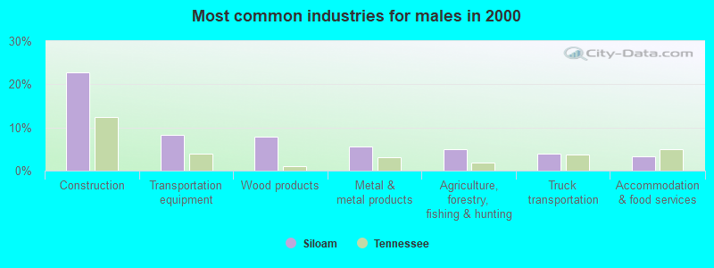
- Construction (22.8%)
- Transportation equipment (8.2%)
- Wood products (7.9%)
- Metal & metal products (5.6%)
- Agriculture, forestry, fishing & hunting (5.0%)
- Truck transportation (4.0%)
- Accommodation & food services (3.2%)
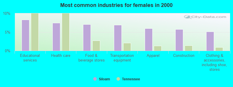
- Educational services (8.3%)
- Health care (7.4%)
- Food & beverage stores (7.0%)
- Transportation equipment (6.9%)
- Apparel (6.0%)
- Construction (5.7%)
- Clothing & accessories, including shoe, stores (5.1%)

- Material recording, scheduling, dispatching, and distributing workers (6.1%)
- Metal workers and plastic workers (5.6%)
- Assemblers and fabricators (5.6%)
- Other production occupations, including supervisors (5.5%)
- Driver/sales workers and truck drivers (4.2%)
- Textile, apparel, and furnishings workers (3.6%)
- Electrical equipment mechanics and other installation, maintenance, and repair workers, including supervisors (3.5%)
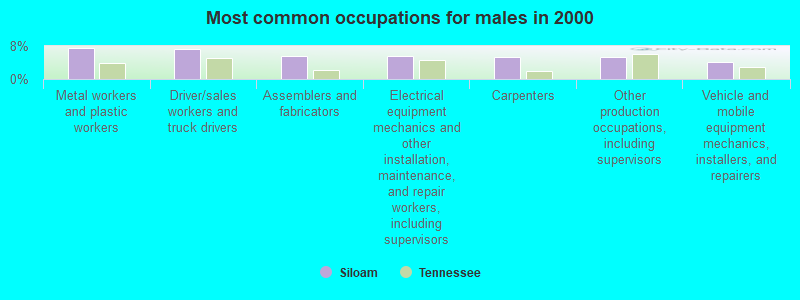
- Metal workers and plastic workers (7.4%)
- Driver/sales workers and truck drivers (7.2%)
- Assemblers and fabricators (5.6%)
- Electrical equipment mechanics and other installation, maintenance, and repair workers, including supervisors (5.5%)
- Carpenters (5.4%)
- Other production occupations, including supervisors (5.3%)
- Vehicle and mobile equipment mechanics, installers, and repairers (4.2%)
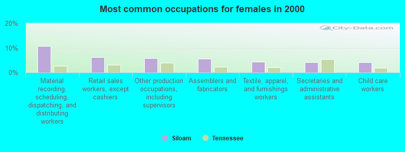
- Material recording, scheduling, dispatching, and distributing workers (10.8%)
- Retail sales workers, except cashiers (6.2%)
- Other production occupations, including supervisors (5.9%)
- Assemblers and fabricators (5.6%)
- Textile, apparel, and furnishings workers (4.3%)
- Secretaries and administrative assistants (4.2%)
- Child care workers (4.2%)
Average climate in Siloam, Tennessee
Based on data reported by over 4,000 weather stations


(lower is better)
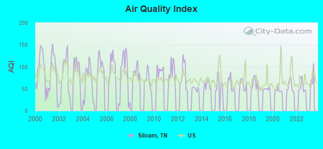
Air Quality Index (AQI) level in 2022 was 53.2. This is better than average.
| City: | 53.2 |
| U.S.: | 72.6 |
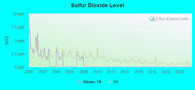
Sulfur Dioxide (SO2) [ppb] level in 2007 was 1.77. This is about average. Closest monitor was 16.7 miles away from the city center.
| City: | 1.77 |
| U.S.: | 1.51 |
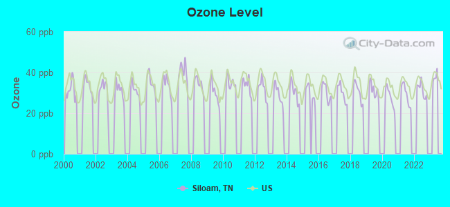
Ozone [ppb] level in 2022 was 31.6. This is about average. Closest monitor was 22.7 miles away from the city center.
| City: | 31.6 |
| U.S.: | 33.3 |
Tornado activity:
Siloam-area historical tornado activity is slightly above Tennessee state average. It is 61% greater than the overall U.S. average.
On 4/27/1970, a category F4 (max. wind speeds 207-260 mph) tornado 10.9 miles away from the Siloam place center killed 3 people and injured 85 people and caused between $500,000 and $5,000,000 in damages.
On 2/6/2008, a category F3 (max. wind speeds 158-206 mph) tornado 7.2 miles away from the place center killed 4 people and injured 11 people and caused $1 million in damages.
Earthquake activity:
Siloam-area historical earthquake activity is significantly above Tennessee state average. It is 164% greater than the overall U.S. average.On 4/18/2008 at 09:36:59, a magnitude 5.4 (5.1 MB, 4.8 MS, 5.4 MW, 5.2 MW, Class: Moderate, Intensity: VI - VII) earthquake occurred 161.7 miles away from the city center
On 4/18/2008 at 09:36:59, a magnitude 5.2 (5.2 MW, Depth: 8.9 mi) earthquake occurred 161.7 miles away from the city center
On 7/27/1980 at 18:52:21, a magnitude 5.2 (5.1 MB, 4.7 MS, 5.0 UK, 5.2 UK) earthquake occurred 167.8 miles away from Siloam center
On 6/18/2002 at 17:37:15, a magnitude 5.0 (4.3 MB, 4.6 MW, 5.0 LG) earthquake occurred 133.1 miles away from Siloam center
On 6/10/1987 at 23:48:54, a magnitude 5.1 (4.9 MB, 4.4 MS, 4.6 MS, 5.1 LG) earthquake occurred 183.0 miles away from the city center
On 4/29/2003 at 08:59:39, a magnitude 4.9 (4.4 MB, 4.6 MW, 4.9 LG, Class: Light, Intensity: IV - V) earthquake occurred 145.4 miles away from Siloam center
Magnitude types: regional Lg-wave magnitude (LG), body-wave magnitude (MB), surface-wave magnitude (MS), moment magnitude (MW)
Natural disasters:
The number of natural disasters in Macon County (14) is near the US average (15).Major Disasters (Presidential) Declared: 11
Emergencies Declared: 2
Causes of natural disasters: Floods: 9, Storms: 9, Tornadoes: 5, Winds: 2, Winter Storms: 2, Flash Flood: 1, Hurricane: 1, Ice Storm: 1, Snowfall: 1, Other: 1 (Note: some incidents may be assigned to more than one category).
Hospitals and medical centers near Siloam:
- MACON COUNTY GENERAL HOSPITAL Critical Access Hospitals (about 9 miles away; LAFAYETTE, TN)
- KNOLLWOOD MANOR (Nursing Home, about 9 miles away; LAFAYETTE, TN)
- HARTSVILLE CONVALESCENT CENTER (Nursing Home, about 12 miles away; HARTSVILLE, TN)
- TROUSDALE MEDICAL CENTER Critical Access Hospitals (about 12 miles away; HARTSVILLE, TN)
- MEDICAL CENTER AT SCOTTSVILLE,THE (Hospital, about 15 miles away; SCOTTSVILLE, KY)
- CAL TURNER REHAB AND SPECIALTY CARE (Nursing Home, about 15 miles away; SCOTTSVILLE, KY)
Colleges/universities with over 2000 students nearest to Siloam:
- Volunteer State Community College (about 23 miles; Gallatin, TN; Full-time enrollment: 5,311)
- Western Kentucky University (about 35 miles; Bowling Green, KY; FT enrollment: 16,942)
- Southcentral Kentucky Community and Technical College (about 35 miles; Bowling Green, KY; FT enrollment: 2,794)
- Trevecca Nazarene University (about 43 miles; Nashville, TN; FT enrollment: 2,223)
- Vanderbilt University (about 45 miles; Nashville, TN; FT enrollment: 10,518)
- Belmont University (about 45 miles; Nashville, TN; FT enrollment: 5,795)
- Tennessee State University (about 45 miles; Nashville, TN; FT enrollment: 7,341)
Points of interest:
Churches in Siloam include: Leaths Chapel (A), Union Hill Church (B), Pisgah Church (C), New Liberty Church (D), Millers Chapel (E), Siloam Baptist Church (F), Rocky Mound Baptist Church (G), Pleasant Valley United Methodist Church (H), Green Grove United Methodist Church (I). Display/hide their locations on the map
Cemeteries: Mount Pleasant Cemetery (1), Lewis Minick Cemetery (2), Millers Chapel Cemetery (3), Love - Ladd Cemetery (4), Black Oak Cemetery (5), William Galbraith Cemetery (6), Fairview Cemetery (7). Display/hide their locations on the map
Streams, rivers, and creeks: Honey Branch (A), Echo Creek (B), Dry Branch (C), Leaths Branch (D), Pop Branch (E), Simmons Branch (F), Tooley Branch (G), Morrison Branch (H). Display/hide their locations on the map
| This place: | 2.8 people |
| Tennessee: | 2.5 people |
| This place: | 63.7% |
| Whole state: | 69.8% |
| This place: | 6.8% |
| Whole state: | 4.2% |
Likely homosexual households (counted as self-reported same-sex unmarried-partner households)
- Lesbian couples: 0.1% of all households
- Gay men: 0.1% of all households
| This place: | 13.2% |
| Whole state: | 13.5% |
| This place: | 5.3% |
| Whole state: | 5.8% |
For population 15 years and over in Siloam:
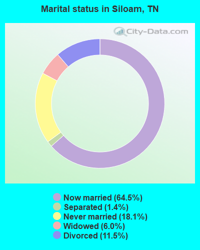
- Never married: 18.1%
- Now married: 64.5%
- Separated: 1.4%
- Widowed: 6.0%
- Divorced: 11.5%
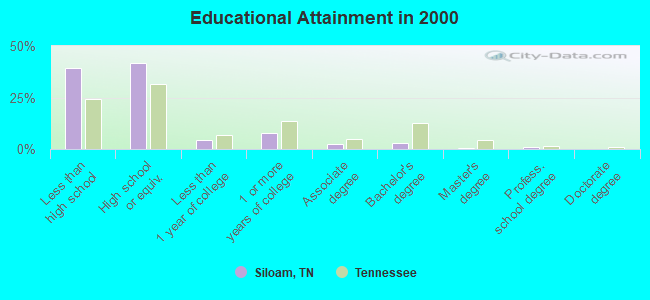
For population 25 years and over in Siloam:
- High school or higher: 60.9%
- Bachelor's degree or higher: 4.7%
- Graduate or professional degree: 1.7%
- Unemployed: 5.4%
- Mean travel time to work (commute): 33.3 minutes
| Here: | 14.9 |
| Tennessee average: | 13.3 |
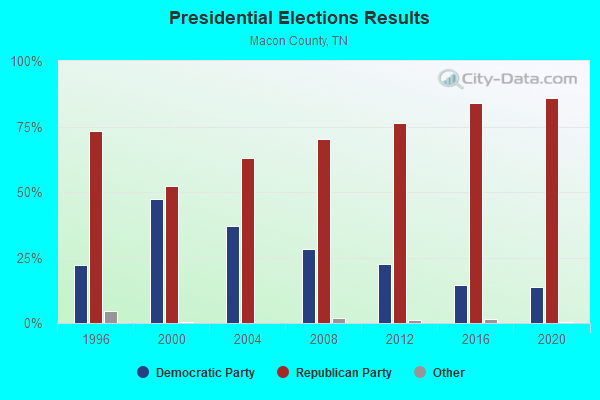

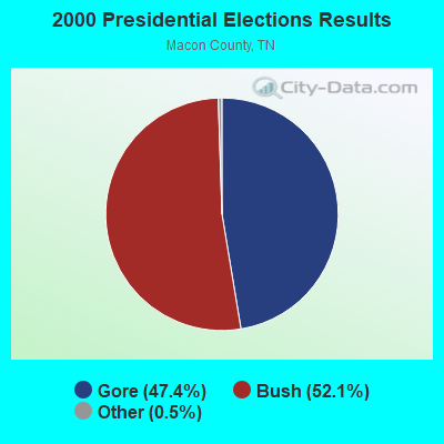


Graphs represent county-level data. Detailed 2008 Election Results
Religion statistics for Siloam, TN (based on Macon County data)
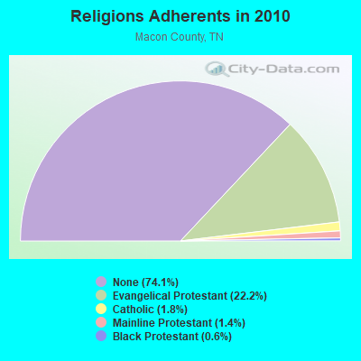
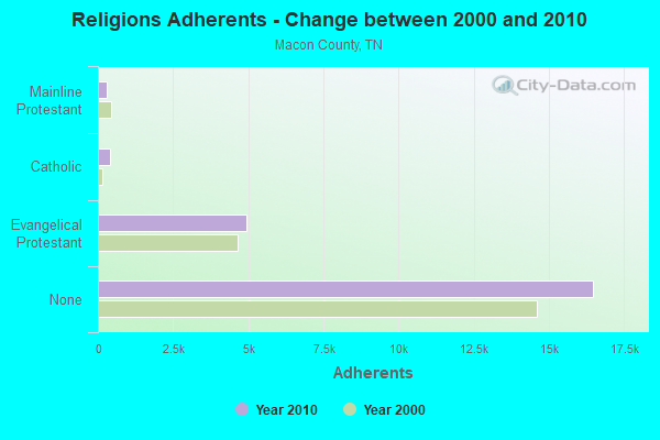
| Religion | Adherents | Congregations |
|---|---|---|
| Evangelical Protestant | 4,942 | 30 |
| Catholic | 400 | 1 |
| Mainline Protestant | 304 | 4 |
| Black Protestant | 124 | 1 |
| Other | - | 1 |
| None | 16,478 | - |
Food Environment Statistics:
| This county: | 2.78 / 10,000 pop. |
| State: | 1.99 / 10,000 pop. |
| This county: | 0.46 / 10,000 pop. |
| State: | 0.17 / 10,000 pop. |
| Macon County: | 4.64 / 10,000 pop. |
| Tennessee: | 5.16 / 10,000 pop. |
| Macon County: | 5.10 / 10,000 pop. |
| Tennessee: | 6.56 / 10,000 pop. |
| Macon County: | 10.3% |
| Tennessee: | 11.4% |
| Macon County: | 30.6% |
| Tennessee: | 30.2% |
| Macon County: | 12.0% |
| State: | 13.5% |
Strongest AM radio stations in Siloam:
- WSM (650 AM; 50 kW; NASHVILLE, TN; Owner: GAYLORD ENTERTAINMENT COMPANY)
- WAMB (1160 AM; 50 kW; DONELSON, TN; Owner: GREAT SOUTHERN BROADCASTING COMPANY, INC.)
- WLAC (1510 AM; 50 kW; NASHVILLE, TN; Owner: CAPSTAR TX LIMITED PARTNERSHIP)
- WKDA (1200 AM; 50 kW; NASHVILLE, TN; Owner: RADIO NASHVILLE, INC.)
- WNQM (1300 AM; 50 kW; NASHVILLE, TN; Owner: WNQM. INC.)
- WHIN (1010 AM; 5 kW; GALLATIN, TN; Owner: WHIN, INC.)
- WPLN (1430 AM; 15 kW; MADISON, TN)
- WTNK (1090 AM; 1 kW; HARTSVILLE, TN; Owner: G & L AIRCASTERS, INC.)
- WEEN (1460 AM; 1 kW; LAFAYETTE, TN; Owner: LAFAYETTE BROADCASTING CO., INC.)
- WYXE (1130 AM; daytime; 2 kW; GALLATIN, TN; Owner: JON GARY ENTERPRISES, INC.)
- WWAM (820 AM; daytime; 50 kW; JASPER, TN; Owner: SHELTON BROADCASTING SYSTEM)
- WKCT (930 AM; 5 kW; BOWLING GREEN, KY; Owner: DAILY NEWS BROADCASTING CO.)
- WLCK (1250 AM; 1 kW; SCOTTSVILLE, KY; Owner: SHERANDAN BROADCASTING CO., INC.)
Strongest FM radio stations in Siloam:
- WLCT (102.1 FM; LAFAYETTE, TN; Owner: LAFAYETTE BROADCASTING CO., INC.)
- WGGC (95.1 FM; GLASGOW, KY; Owner: HERITAGE COMMUNICATIONS, INC.)
- WGFX (104.5 FM; GALLATIN, TN; Owner: CITADEL BROADCASTING COMPANY)
- WVLE (99.3 FM; SCOTTSVILLE, KY; Owner: SHERANDAN BROADCASTING COMPANY, INC.)
- WMAK (96.3 FM; MURFREESBORO, TN; Owner: SOUTH CENTRAL COMMUNICATIONS CORP.)
- WMOT (89.5 FM; MURFREESBORO, TN; Owner: MIDDLE TENNESSEE STATE UNIVERSITY)
- WRVW (107.5 FM; LEBANON, TN; Owner: CAPSTAR TX LIMITED PARTNERSHIP)
- W230AD (93.9 FM; GALLATIN, TN; Owner: TREVECCA NAZARENE UNIVERSITY, INC.)
- WVCP (88.5 FM; GALLATIN, TN; Owner: VOLUNTEER STATE COMMUNITY COLLEGE)
- WUBT (101.1 FM; RUSSELLVILLE, KY; Owner: CAPSTAR TX LIMITED PARTNERSHIP)
- WSM-FM (95.5 FM; NASHVILLE, TN; Owner: CUMULUS LICENSING CORP.)
- WUCZ (104.1 FM; CARTHAGE, TN; Owner: WOOD BROADCASTING, INC.)
- WKYU-FM (88.9 FM; BOWLING GREEN, KY; Owner: WESTERN KENTUCKY UNIVERSITY)
- WDNS (93.3 FM; BOWLING GREEN, KY; Owner: DAILY NEWS BROADCASTING COMPANY)
- WANT (98.9 FM; LEBANON, TN; Owner: BAY-POINTE BROADCASTING, INC.)
TV broadcast stations around Siloam:
- WPGD (Channel 50; HENDERSONVILLE, TN; Owner: TRINITY BROADCASTING NETWORK)
- WTVF (Channel 5; NASHVILLE, TN; Owner: NEWSCHANNEL 5 NETWORK, LP)
- WNPX (Channel 28; COOKEVILLE, TN; Owner: PAXSON COMMUNICATIONS LICENSE COMPANY, LLC)
- WUXP-TV (Channel 30; NASHVILLE, TN; Owner: WUXP LICENSEE, LLC)
- WPBM-LP (Channel 48; SCOTTSVILLE, KY; Owner: PROCLAIM BROADCASTING, INC.)
- WSMV-TV (Channel 4; NASHVILLE, TN; Owner: MEREDITH CORPORATION)
- WHTN (Channel 39; MURFREESBORO, TN; Owner: CHRISTIAN TELEVISION NETWORK, INC.)
- WZTV (Channel 17; NASHVILLE, TN; Owner: WZTV LICENSEE, LLC)
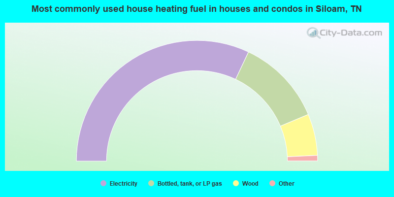
- 64.0%Electricity
- 23.3%Bottled, tank, or LP gas
- 11.1%Wood
- 1.0%Utility gas
- 0.5%Fuel oil, kerosene, etc.
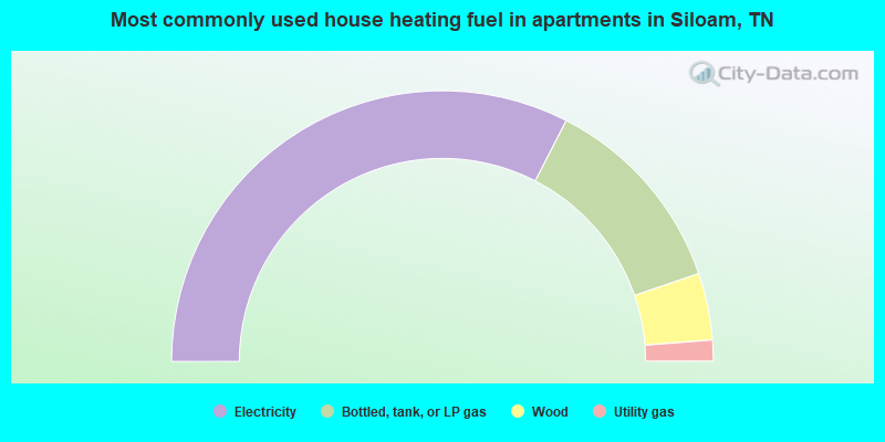
- 65.1%Electricity
- 24.4%Bottled, tank, or LP gas
- 8.0%Wood
- 2.5%Utility gas
Siloam compared to Tennessee state average:
- Unemployed percentage below state average.
- Black race population percentage significantly below state average.
- Hispanic race population percentage significantly below state average.
- Median age below state average.
- Foreign-born population percentage significantly below state average.
- Renting percentage significantly below state average.
- Length of stay since moving in significantly above state average.
- Number of rooms per house significantly below state average.
- House age significantly below state average.
- Number of college students significantly below state average.
- Percentage of population with a bachelor's degree or higher significantly below state average.