Sprague, Connecticut
Submit your own pictures of this town and show them to the world
- OSM Map
- Google Map
- MSN Map
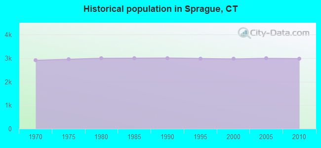
Population change since 2000: +0.4%
 |
| Males: 1,469 | |
| Females: 1,515 |
| Median resident age: | 38.5 years |
| Connecticut median age: | 39.2 years |
Zip codes: 06330.
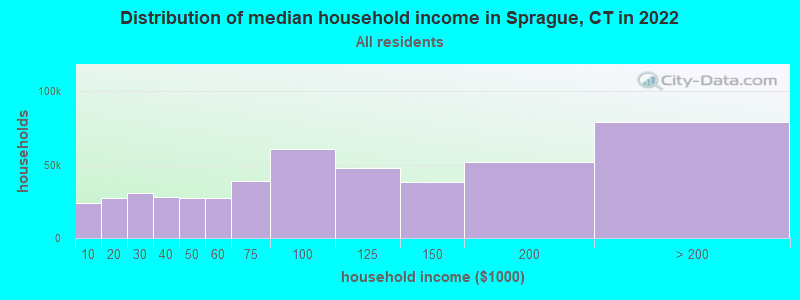
| Sprague: | $70,705 |
| CT: | $88,429 |
Estimated per capita income in 2022: $37,290 (it was $20,796 in 2000)
Sprague town income, earnings, and wages data
Estimated median house or condo value in 2022: $287,532 (it was $133,000 in 2000)
| Sprague: | $287,532 |
| CT: | $347,200 |
Mean prices in 2022: all housing units: $336,024; detached houses: $358,368; townhouses or other attached units: $232,367; in 2-unit structures: $294,123; in 3-to-4-unit structures: $234,423; in 5-or-more-unit structures: $212,293; mobile homes: $38,564; occupied boats, rvs, vans, etc.: $86,722
Detailed information about poverty and poor residents in Sprague, CT
Compare current foreclosures near Sprague, CT:
| Photo | Address | Area | Beds / Baths | Price | Details |
|---|---|---|---|---|---|

|
#1
Lake Dr E
Oakdale, CT 06370
|
1,346 sq. feet
|
1 baths 3 beds |
$365,000
|
show details |

|
#2
N Society Rd
Canterbury, CT 06331
|
768 sq. feet
|
1 baths 2 beds |
$269,900
|
show details |

|
#3
Broad St
Norwich, CT 06360
|
1,703 sq. feet
|
1 baths 4 beds |
show details | |

|
#4
Circle Dr
Mansfield Center, CT 06250
|
1,152 sq. feet
|
1 baths 3 beds |
show details | |

|
#5
Division St
Norwich, CT 06360
|
1,648 sq. feet
|
1 baths 2 beds |
show details | |

|
#6
Boswell Ave
Norwich, CT 06360
|
2,244 sq. feet
|
4 baths 4 beds |
show details | |

|
#7
Mansfield Ave
Willimantic, CT 06226
|
920 sq. feet
|
1 baths 3 beds |
show details | |

|
#8
Dow Rd
Plainfield, CT 06374
|
1,632 sq. feet
|
1 baths 3 beds |
show details | |

|
#9
Long Cove Rd
Gales Ferry, CT 06335
|
2,257 sq. feet
|
2 baths 3 beds |
show details | |

|
#10
Way Rd
Salem, CT 06420
|
1,040 sq. feet
|
1 baths 3 beds |
show details |
| Photo | Address | Area | Beds / Baths | Price | Details |
|---|---|---|---|---|---|

|
#11
Willimantic Rd
Chaplin, CT 06235
|
2,282 sq. feet
|
3 baths 5 beds |
show details | |

|
#12
Nipmuc Trl
West Greenwich, RI 02817
|
1,228 sq. feet
|
2 baths 2 beds |
show details | |

|
#13
Mathewson Mill Rd
Preston, CT 06365
|
3,240 sq. feet
|
2 baths 3 beds |
show details | |

|
#14
South St
Coventry, CT 06238
|
1,821 sq. feet
|
2 baths 3 beds |
show details | |

|
#15
Mohegan Avenue Pkwy
Quaker Hill, CT 06375
|
1,330 sq. feet
|
1 baths 3 beds |
show details | |

|
#16
Calvin Burnham Rd
Hampton, CT 06247
|
1,156 sq. feet
|
2 baths 2 beds |
show details | |

|
#17
Gibson Hill Rd
Sterling, CT 06377
|
1,764 sq. feet
|
1 baths 4 beds |
show details | |

|
#18
Shingle Point Rd
Preston, CT 06365
|
2,181 sq. feet
|
3 baths 4 beds |
show details | |

|
#19
W Park St
Willimantic, CT 06226
|
1,214 sq. feet
|
1 baths 3 beds |
show details | |

|
#20
Orchard Hill Ln
Willimantic, CT 06226
|
960 sq. feet
|
1 baths 3 beds |
show details |
| Photo | Address | Area | Beds / Baths | Price | Details |
|---|---|---|---|---|---|

|
#21
Glasgo Rd Lot 208
Jewett City, CT 06351
|
1,680 sq. feet
|
2 baths 3 beds |
show details | |

|
#22
Glasgo Rd Lot 208
Jewett City, CT 06351
|
1,680 sq. feet
|
2 baths 3 beds |
show details | |

|
#23
Holbrook Ave
Willimantic, CT 06226
|
1,536 sq. feet
|
2 baths 4 beds |
show details | |

|
#24
Meeting House Ln
Ledyard, CT 06339
|
1,312 sq. feet
|
1 baths 4 beds |
show details | |

|
#25
Tuckie Rd
North Windham, CT 06256
|
1,144 sq. feet
|
1 baths 3 beds |
show details | |

|
#26
Lathrop Rd
Uncasville, CT 06382
|
1,500 sq. feet
|
3 baths 3 beds |
show details | |

|
#27
Blacksmith Dr
Ledyard, CT 06339
|
1,196 sq. feet
|
2 baths 4 beds |
show details | |

|
#28
Moxley Rd
Uncasville, CT 06382
|
1,118 sq. feet
|
2 baths 3 beds |
show details | |

|
#29
Sachem Ln
Ledyard, CT 06339
|
1,200 sq. feet
|
1 baths 3 beds |
show details | |

|
#30
Kennedy Dr
Colchester, CT 06415
|
1,132 sq. feet
|
2 baths 3 beds |
show details |
| Photo | Address | Area | Beds / Baths | Price | Details |
|---|---|---|---|---|---|

|
#31
West Dr
Gales Ferry, CT 06335
|
1,440 sq. feet
|
2 baths 3 beds |
show details | |

|
#32
Putnam Pl
Brooklyn, CT 06234
|
2,786 sq. feet
|
2 baths 4 beds |
show details | |

|
#33
Costello Rd
Brooklyn, CT 06234
|
2,010 sq. feet
|
2 baths 3 beds |
show details | |

|
#34
Brooklyn Rd
Pomfret Center, CT 06259
|
1,951 sq. feet
|
1 baths 4 beds |
show details | |

|
#35
Lake Dr E
Oakdale, CT 06370
|
1,371 sq. feet
|
2 baths 3 beds |
show details | |

|
#36
Gorman Rd
Brooklyn, CT 06234
|
2,630 sq. feet
|
2 baths 3 beds |
show details | |

|
#37
Lantern Hill Rd
Ledyard, CT 06339
|
1,338 sq. feet
|
2 baths 3 beds |
show details | |

|
#38
High St
Moosup, CT 06354
|
4,857 sq. feet
|
4 baths 4 beds |
show details | |

|
#39
Carolina Dr Apt 21
Oakdale, CT 06370
|
960 sq. feet
|
1 baths 2 beds |
show details | |

|
#40
Brooklyn Rd
Pomfret Center, CT 06259
|
1,951 sq. feet
|
1 baths 4 beds |
show details |
| Photo | Address | Area | Beds / Baths | Price | Details |
|---|---|---|---|---|---|

|
#41
Tobacco St
Lebanon, CT 06249
|
1,100 sq. feet
|
2 baths 3 beds |
show details | |

|
#42
Ward Ave
Moosup, CT 06354
|
1,808 sq. feet
|
2 baths 3 beds |
show details | |

|
#43
Park Ave
Colchester, CT 06415
|
1,224 sq. feet
|
1 baths 3 beds |
show details | |

|
#44
Lovers Ln
Plainfield, CT 06374
|
1,992 sq. feet
|
2 baths 3 beds |
show details | |

|
#45
Banjo Sullivan Rd
Jewett City, CT 06351
|
1,564 sq. feet
|
2 baths 4 beds |
show details | |

|
#46
Patricia Ct
Gales Ferry, CT 06335
|
1,262 sq. feet
|
2 baths 4 beds |
show details | |

|
#47
Hopeville Rd
Jewett City, CT 06351
|
1,939 sq. feet
|
2 baths 3 beds |
show details | |

|
#48
Prospect St
Norwich, CT 06360
|
1,572 sq. feet
|
1 baths 3 beds |
show details | |

|
#49
Starr St
Norwich, CT 06360
|
2,207 sq. feet
|
2 baths 4 beds |
show details | |

|
Check over 1 million property listings on Foreclosure.com!
|
browse all offers | |||

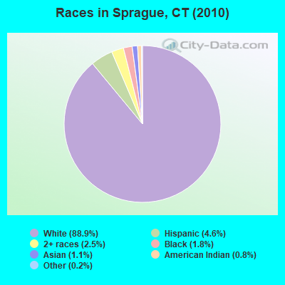
- 2,65488.9%White alone
- 1384.6%Hispanic
- 762.5%Two or more races
- 541.8%Black alone
- 331.1%Asian alone
- 230.8%American Indian alone
- 50.2%Other race alone
- 10.03%Native Hawaiian and Other
Pacific Islander alone
Races in Sprague detailed stats: ancestries, foreign born residents, place of birth
 Recent articles from our blog. Our writers, many of them Ph.D. graduates or candidates, create easy-to-read articles on a wide variety of topics.
Ancestries: French (21.5%), French Canadian (17.3%), Irish (15.8%), Italian (15.3%), English (12.7%), Polish (12.5%).
Current Local Time: EST time zone
Incorporated on 05/1861
Land area: 13.2 square miles.
Population density: 226 people per square mile (very low).
106 residents are foreign born (1.9% Asia, 1.6% Europe).
| This town: | 3.6% |
| Connecticut: | 10.9% |
| Sprague town: | 1.4% ($1,922) |
| Connecticut: | 1.8% ($2,961) |
Nearest city with pop. 50,000+: Manchester, CT  (25.9 miles , pop. 54,740).
Nearest city with pop. 200,000+: Boston, MA (69.9 miles , pop. 589,141).
Nearest city with pop. 1,000,000+: Bronx, NY (108.0 miles , pop. 1,332,650).
Nearest cities:
), ), ), ), ), Latitude: 41.62 N, Longitude: 72.07 W
Area code commonly used in this area: 860
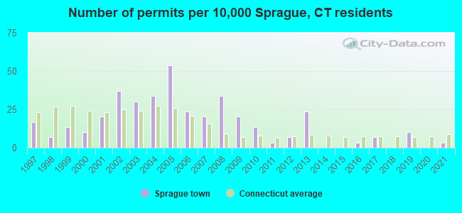
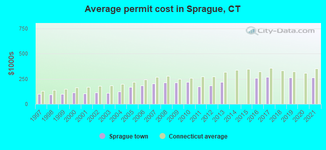
Single-family new house construction building permits:
- 2021: 1 building, cost: $262,500
- 2019: 3 buildings, average cost: $263,600
- 2017: 2 buildings, average cost: $267,800
- 2016: 1 building, cost: $257,200
- 2013: 7 buildings, average cost: $216,900
- 2012: 2 buildings, average cost: $184,000
- 2011: 1 building, cost: $172,800
- 2010: 4 buildings, average cost: $220,200
- 2009: 6 buildings, average cost: $215,000
- 2008: 10 buildings, average cost: $213,200
- 2007: 6 buildings, average cost: $203,800
- 2006: 7 buildings, average cost: $186,200
- 2005: 16 buildings, average cost: $168,900
- 2004: 10 buildings, average cost: $121,900
- 2003: 9 buildings, average cost: $111,000
- 2002: 11 buildings, average cost: $112,400
- 2001: 6 buildings, average cost: $105,800
- 2000: 3 buildings, average cost: $115,700
- 1999: 4 buildings, average cost: $96,800
- 1998: 2 buildings, average cost: $95,000
- 1997: 5 buildings, average cost: $100,400
| Here: | 3.8% |
| Connecticut: | 3.9% |
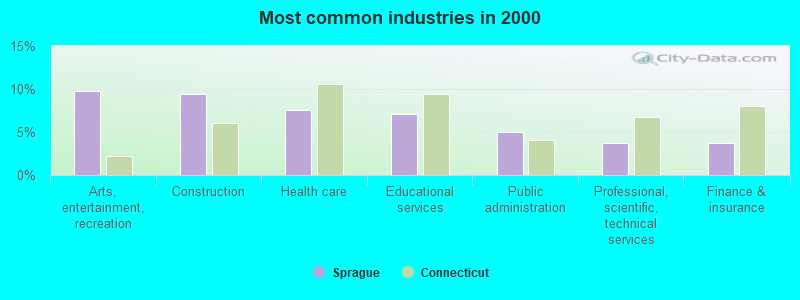
- Arts, entertainment, recreation (9.8%)
- Construction (9.4%)
- Health care (7.6%)
- Educational services (7.1%)
- Public administration (4.9%)
- Professional, scientific, technical services (3.7%)
- Finance & insurance (3.7%)
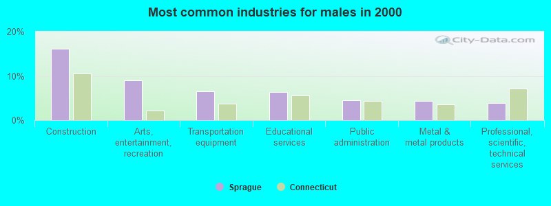
- Construction (16.1%)
- Arts, entertainment, recreation (9.0%)
- Transportation equipment (6.6%)
- Educational services (6.3%)
- Public administration (4.5%)
- Metal & metal products (4.4%)
- Professional, scientific, technical services (3.9%)
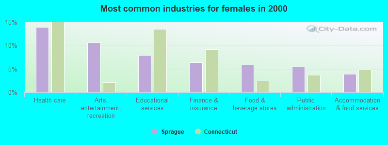
- Health care (14.0%)
- Arts, entertainment, recreation (10.6%)
- Educational services (8.0%)
- Finance & insurance (6.4%)
- Food & beverage stores (5.9%)
- Public administration (5.5%)
- Accommodation & food services (3.9%)
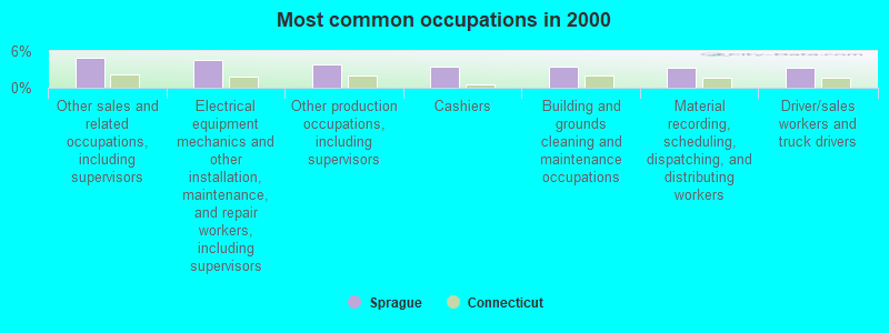
- Other sales and related occupations, including supervisors (4.9%)
- Electrical equipment mechanics and other installation, maintenance, and repair workers, including supervisors (4.5%)
- Other production occupations, including supervisors (3.9%)
- Cashiers (3.5%)
- Building and grounds cleaning and maintenance occupations (3.4%)
- Material recording, scheduling, dispatching, and distributing workers (3.3%)
- Driver/sales workers and truck drivers (3.3%)
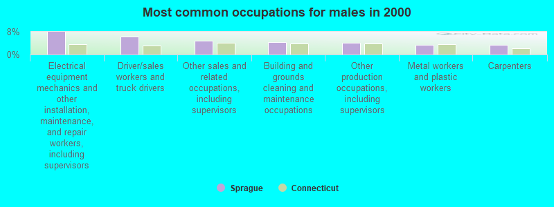
- Electrical equipment mechanics and other installation, maintenance, and repair workers, including supervisors (7.9%)
- Driver/sales workers and truck drivers (6.2%)
- Other sales and related occupations, including supervisors (4.9%)
- Building and grounds cleaning and maintenance occupations (4.4%)
- Other production occupations, including supervisors (4.0%)
- Metal workers and plastic workers (3.4%)
- Carpenters (3.4%)
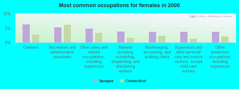
- Cashiers (6.4%)
- Secretaries and administrative assistants (5.3%)
- Other sales and related occupations, including supervisors (4.9%)
- Material recording, scheduling, dispatching, and distributing workers (3.9%)
- Bookkeeping, accounting, and auditing clerks (3.8%)
- Supervisors and other personal care and service workers, except child care workers (3.8%)
- Other production occupations, including supervisors (3.8%)
Average climate in Sprague, Connecticut
Based on data reported by over 4,000 weather stations


(lower is better)
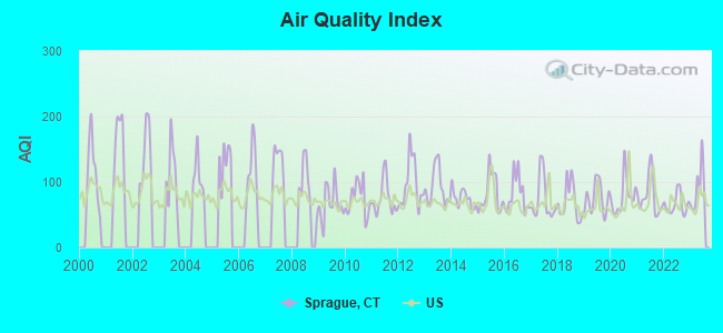
Air Quality Index (AQI) level in 2023 was 90.3. This is worse than average.
| City: | 90.3 |
| U.S.: | 72.6 |
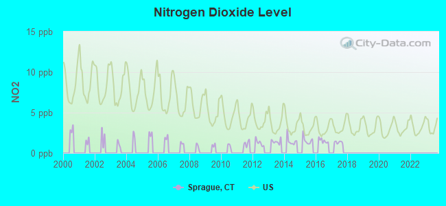
Nitrogen Dioxide (NO2) [ppb] level in 2017 was 1.35. This is significantly better than average. Closest monitor was 6.7 miles away from the city center.
| City: | 1.35 |
| U.S.: | 5.11 |
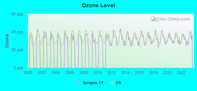
Ozone [ppb] level in 2023 was 34.6. This is about average. Closest monitor was 15.3 miles away from the city center.
| City: | 34.6 |
| U.S.: | 33.3 |
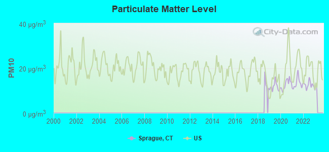
Particulate Matter (PM10) [µg/m3] level in 2022 was 12.6. This is significantly better than average. Closest monitor was 6.7 miles away from the city center.
| City: | 12.6 |
| U.S.: | 19.2 |
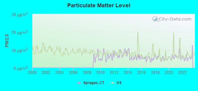
Particulate Matter (PM2.5) [µg/m3] level in 2022 was 5.21. This is significantly better than average. Closest monitor was 6.7 miles away from the city center.
| City: | 5.21 |
| U.S.: | 8.11 |
Tornado activity:
Sprague-area historical tornado activity is slightly below Connecticut state average. It is 39% smaller than the overall U.S. average.
On 10/3/1979, a category F4 (max. wind speeds 207-260 mph) tornado 35.8 miles away from the Sprague town center killed 3 people and injured 500 people and caused between $50,000,000 and $500,000,000 in damages.
On 8/21/1951, a category F3 (max. wind speeds 158-206 mph) tornado 22.5 miles away from the town center injured 8 people and caused between $50,000 and $500,000 in damages.
Earthquake activity:
Sprague-area historical earthquake activity is significantly above Connecticut state average. It is 72% smaller than the overall U.S. average.On 10/7/1983 at 10:18:46, a magnitude 5.3 (5.1 MB, 5.3 LG, 5.1 ML, Class: Moderate, Intensity: VI - VII) earthquake occurred 198.3 miles away from Sprague center
On 4/20/2002 at 10:50:47, a magnitude 5.3 (5.3 ML, Depth: 3.0 mi) earthquake occurred 216.3 miles away from Sprague center
On 4/20/2002 at 10:50:47, a magnitude 5.2 (5.2 MB, 4.2 MS, 5.2 MW, 5.0 MW) earthquake occurred 215.1 miles away from Sprague center
On 1/19/1982 at 00:14:42, a magnitude 4.7 (4.5 MB, 4.7 MD, 4.5 LG, Class: Light, Intensity: IV - V) earthquake occurred 132.2 miles away from the city center
On 10/16/2012 at 23:12:25, a magnitude 4.7 (4.7 ML, Depth: 10.0 mi) earthquake occurred 154.5 miles away from the city center
On 8/22/1992 at 12:20:32, a magnitude 4.8 (4.8 MB, 3.8 MS, 4.7 LG, Depth: 6.2 mi) earthquake occurred 196.9 miles away from the city center
Magnitude types: regional Lg-wave magnitude (LG), body-wave magnitude (MB), duration magnitude (MD), local magnitude (ML), surface-wave magnitude (MS), moment magnitude (MW)
Natural disasters:
The number of natural disasters in New London County (22) is greater than the US average (15).Major Disasters (Presidential) Declared: 12
Emergencies Declared: 10
Causes of natural disasters: Hurricanes: 6, Snowstorms: 5, Storms: 5, Floods: 4, Blizzards: 3, Winter Storms: 3, Snows: 2, Snowfall: 1, Tropical Storm: 1, Wind: 1 (Note: some incidents may be assigned to more than one category).
Hospitals and medical centers near Sprague:
- BACKUS HOME HEALTH CARE (Home Health Center, about 5 miles away; NORWICH, CT)
- INTERIM HEALTH CARE OF EASTERN (Home Health Center, about 5 miles away; NORWICH, CT)
- NORWICHTOWN REHABILITATION AND C (Nursing Home, about 6 miles away; NORWICH, CT)
- UNITED COMM SVCS INC PHN DEPT-HOSPICE (Hospital, about 6 miles away; NORWICH, CT)
- WILLIAM W BACKUS HOSPITAL Acute Care Hospitals (about 6 miles away; NORWICH, CT)
- ELMACHRI REST HOME (Nursing Home, about 6 miles away; NORWICH, CT)
- HAMILTON PAVILION HEALTHCARE (Nursing Home, about 7 miles away; NORWICH, CT)
Amtrak stations near Sprague:
- 13 miles: FOXWOOD CASINO (LEDYARD, ROUTE 2) - Bus Station
- 19 miles: NEW LONDON (27 WATER ST.) . Services: ticket office, partially wheelchair accessible, enclosed waiting area, public restrooms, public payphones, paid short-term parking, paid long-term parking, call for car rental service, taxi stand, intercity bus service, public transit connection.
- 20 miles: MYSTIC (RTE. 1) . Services: enclosed waiting area, public restrooms, public payphones, free short-term parking, call for car rental service, call for taxi service, public transit connection.
Operable nuclear power plants near Sprague:
- 19 miles: Millstone 1 and 2 in Waterford, CT.
- 19 miles: Millstone 3 in Waterford, CT.
Colleges/universities with over 2000 students nearest to Sprague:
- Three Rivers Community College (about 8 miles; Norwich, CT; Full-time enrollment: 2,897)
- Eastern Connecticut State University (about 11 miles; Willimantic, CT; FT enrollment: 4,985)
- University of Connecticut (about 16 miles; Storrs, CT; FT enrollment: 22,037)
- Connecticut College (about 17 miles; New London, CT; FT enrollment: 2,068)
- Manchester Community College (about 28 miles; Manchester, CT; FT enrollment: 4,667)
- New England Institute of Technology (about 30 miles; East Greenwich, RI; FT enrollment: 3,183)
- University of Rhode Island (about 30 miles; Kingston, RI; FT enrollment: 14,656)
Points of interest:
Notable locations in Sprague: Pautipaug Golf Course and Country Club (A), Baltic Fire Department (B). Display/hide their locations on the map
Churches in Sprague include: Baltic United Methodist Church (A), Hanover Congregational Church (B), Saint Marys Roman Catholic Church (C), Versailles United Methodist Church (D). Display/hide their locations on the map
Cemetery: Saint Manes Cemetery (1). Display/hide its location on the map
Lakes and reservoirs: Versailles Pond (A), Papermill Pond (B), Baltic Reservoir (C), Hanover Reservoir (D). Display/hide their locations on the map
Streams, rivers, and creeks: Old Stone Mill Brook (A), Adams Brook (B), Beaver Brook (C), Waldo Brook (D). Display/hide their locations on the map
Park in Sprague: Baltic Historic District (1). Display/hide its location on the map
Birthplace of: Charles S. Whitman - Judge.
| This town: | 2.6 people |
| Connecticut: | 2.5 people |
| This town: | 70.7% |
| Whole state: | 66.3% |
| This town: | 8.2% |
| Whole state: | 6.6% |
Likely homosexual households (counted as self-reported same-sex unmarried-partner households)
- Lesbian couples: 0.5% of all households
- Gay men: 0.1% of all households
| This town: | 6.4% |
| Whole state: | 7.9% |
| This town: | 2.3% |
| Whole state: | 3.9% |
For population 15 years and over in Sprague:
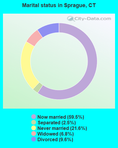
- Never married: 21.6%
- Now married: 59.5%
- Separated: 2.5%
- Widowed: 6.8%
- Divorced: 9.6%
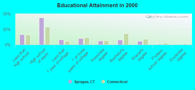
For population 25 years and over in Sprague:
- High school or higher: 83.5%
- Bachelor's degree or higher: 14.6%
- Graduate or professional degree: 6.9%
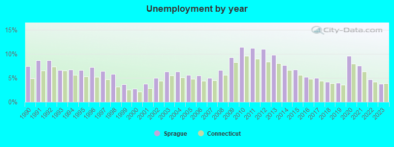
- Unemployed: 4.8%
- Mean travel time to work (commute): 24.7 minutes
| Here: | 9.9 |
| Connecticut average: | 12.8 |
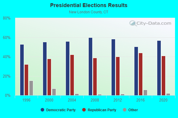
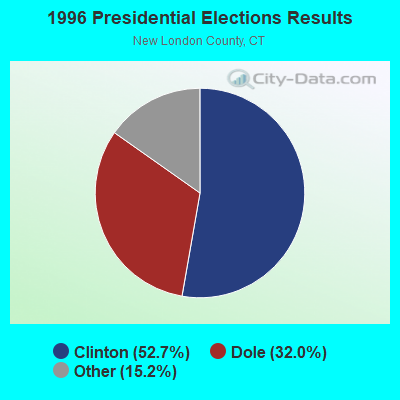
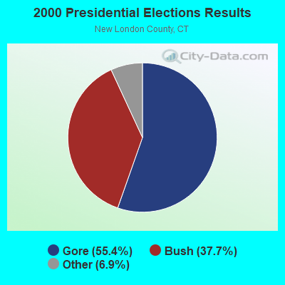

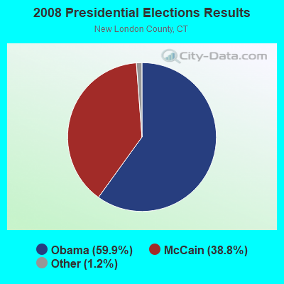

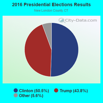
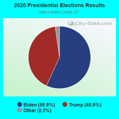
Graphs represent county-level data. Detailed 2008 Election Results
Religion statistics for Sprague, CT (based on New London County data)
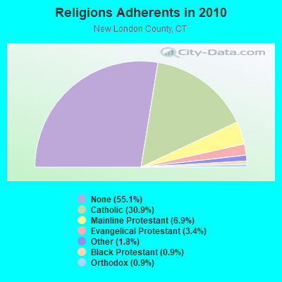
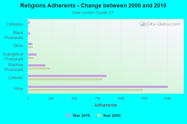
| Religion | Adherents | Congregations |
|---|---|---|
| Catholic | 84,765 | 34 |
| Mainline Protestant | 18,993 | 79 |
| Evangelical Protestant | 9,320 | 75 |
| Other | 5,022 | 32 |
| Black Protestant | 2,594 | 10 |
| Orthodox | 2,456 | 4 |
| None | 150,905 | - |
Food Environment Statistics:
| New London County: | 1.82 / 10,000 pop. |
| Connecticut: | 2.21 / 10,000 pop. |
| Here: | 0.11 / 10,000 pop. |
| State: | 0.07 / 10,000 pop. |
| New London County: | 1.36 / 10,000 pop. |
| Connecticut: | 1.02 / 10,000 pop. |
| New London County: | 3.22 / 10,000 pop. |
| Connecticut: | 2.27 / 10,000 pop. |
| Here: | 10.01 / 10,000 pop. |
| State: | 9.19 / 10,000 pop. |
| This county: | 7.6% |
| State: | 7.3% |
| Here: | 22.4% |
| Connecticut: | 21.5% |
| New London County: | 16.5% |
| Connecticut: | 15.8% |
6.16% of this county's 2021 resident taxpayers lived in other counties in 2020 ($81,025 average adjusted gross income)
| Here: | 6.16% |
| Connecticut average: | 5.79% |
0.04% of residents moved from foreign countries ($359 average AGI)
New London County: 0.04% Connecticut average: 0.02%
Top counties from which taxpayers relocated into this county between 2020 and 2021:
| from Hartford County, CT | |
| from Windham County, CT | |
| from Middlesex County, CT |
6.02% of this county's 2020 resident taxpayers moved to other counties in 2021 ($71,482 average adjusted gross income)
| Here: | 6.02% |
| Connecticut average: | 5.82% |
0.05% of residents moved to foreign countries ($502 average AGI)
New London County: 0.05% Connecticut average: 0.02%
Top counties to which taxpayers relocated from this county between 2020 and 2021:
| to Hartford County, CT | |
| to Windham County, CT | |
| to Middlesex County, CT |
Strongest AM radio stations in Sprague:
- WICH (1310 AM; 5 kW; NORWICH, CT; Owner: WICH, INCORPORATED)
- WALE (990 AM; 50 kW; GREENVILLE, RI; Owner: NORTH AMERICAN BROADCASTING CO., INC.)
- WCRN (830 AM; 50 kW; WORCESTER, MA; Owner: CARTER BROADCASTING CORPORATION)
- WTIC (1080 AM; 50 kW; HARTFORD, CT; Owner: INFINITY RADIO OPERATIONS INC.)
- WNNZ (640 AM; 50 kW; WESTFIELD, MA; Owner: CLEAR CHANNEL BROADCASTING LICENSES, INC.)
- WVNE (760 AM; daytime; 25 kW; LEICESTER, MA; Owner: BLOUNT MASSCOM, INC.)
- WEEI (850 AM; 50 kW; BOSTON, MA; Owner: ENTERCOM BOSTON LICENSE, LLC)
- WKOX (1200 AM; 50 kW; FRAMINGHAM, MA; Owner: CAPSTAR TX LIMITED PARTNERSHIP)
- WRKO (680 AM; 50 kW; BOSTON, MA; Owner: ENTERCOM BOSTON LICENSE, LLC)
- WBIX (1060 AM; 40 kW; NATICK, MA; Owner: LANGER BROADCASTING CORPORATION)
- WAMG (890 AM; 25 kW; DEDHAM, MA; Owner: MEGA COMMUNICATIONS OF DEDHAM LICENSEE, LLC)
- WILI (1400 AM; 1 kW; WILLIMANTIC, CT; Owner: THE NUTMEG BROADCASTING CO.)
- WBZ (1030 AM; 50 kW; BOSTON, MA; Owner: INFINITY BROADCASTING OPERATIONS, INC.)
Strongest FM radio stations in Sprague:
- WILI-FM (98.3 FM; WILLIMANTIC, CT; Owner: NUTMEG BROADCASTING COMPANY)
- WECS (90.1 FM; WILLIMANTIC, CT; Owner: EASTERN CONNECTICUT STATE COLLEGE)
- WCTY (97.7 FM; NORWICH, CT; Owner: WICH, INC.)
- WBMW (106.5 FM; LEDYARD, CT; Owner: RED WOLF BROADCASTING CORPORATION)
- WHJM (107.7 FM; PAWCATUCK, CT; Owner: FULLER BROADCASTING INTERNATIONAL, LLC)
- WWRX-FM (103.7 FM; WESTERLY, RI; Owner: FNX BROADCASTING OF RHODE ISLAND, LLC)
- WHUS (91.7 FM; STORRS, CT; Owner: THE BD. OF TRUSTEES, THE UNIV. OF CT)
- WKNL (100.9 FM; NEW LONDON, CT; Owner: HALL COMMUNICATIONS, INC.)
- WRCH (100.5 FM; NEW BRITAIN, CT; Owner: INFINITY RADIO OPERATIONS INC.)
- W258AC (99.5 FM; STORRS, CT; Owner: CONNECTICUT PUBLIC BROADCASTING, INC)
- WSKO-FM (99.7 FM; WAKEFIELD-PEACEDALE, RI; Owner: CITADEL BROADCASTING COMPANY)
- WQGN-FM (105.5 FM; GROTON, CT; Owner: CITADEL BROADCASTING COMPANY)
- WXLM (102.3 FM; STONINGTON, CT; Owner: CITADEL BROADCASTING COMPANY)
- WKSS (95.7 FM; HARTFORD-MERIDEN, CT; Owner: CAPSTAR TX LIMITED PARTNERSHIP)
- WWYZ (92.5 FM; WATERBURY, CT; Owner: CAPSTAR TX LIMITED PARTNERSHIP)
- WZMX (93.7 FM; HARTFORD, CT; Owner: INFINITY RADIO OPERATIONS INC.)
- WHCN (105.9 FM; HARTFORD, CT; Owner: CAPSTAR TX LIMITED PARTNERSHIP)
- WWBB (101.5 FM; PROVIDENCE, RI; Owner: CLEAR CHANNEL BROADCASTING LICENSES, INC.)
- WMRQ (104.1 FM; WATERBURY, CT; Owner: CAPSTAR TX LIMITED PARTNERSHIP)
- WTIC-FM (96.5 FM; HARTFORD, CT; Owner: INFINITY RADIO OPERATIONS INC.)
TV broadcast stations around Sprague:
- WHPX (Channel 26; NEW LONDON, CT; Owner: PAXSON HARTFORD LICENSE, INC.)
- WEDN (Channel 53; NORWICH, CT; Owner: CONNECTICUT PUBLIC BROADCASTING, INC.)
- WPXQ (Channel 69; BLOCK ISLAND, RI; Owner: OCEAN STATE TELEVISION, L.L.C.)
- WTIC-TV (Channel 61; HARTFORD, CT; Owner: TRIBUNE TELEVISION COMPANY)
- W11BJ (Channel 11; HARTFORD, CT; Owner: COMMUNICATIONS SITE MANAGEMENT LLC)
- WYDN (Channel 48; WORCESTER, MA; Owner: EDUCATIONAL PUBLIC TV CORPORATION)
- WTXX (Channel 20; WATERBURY, CT; Owner: WTXX INC.)
- WUVN (Channel 18; HARTFORD, CT; Owner: ENTRAVISION HOLDINGS, LLC)
- WVIT (Channel 30; NEW BRITAIN, CT; Owner: OUTLET BROADCASTING, INC)
- WEDH (Channel 24; HARTFORD, CT; Owner: CONNECTICUT PUBLIC BROADCASTING, INC.)
- WNAC-TV (Channel 64; PROVIDENCE, RI; Owner: WNAC, LLC)
- WRIW-LP (Channel 50; PROVIDENCE, RI; Owner: ZGS PROVIDENCE, INC.)
Medal of Honor Recipients
Medal of Honor Recipient born in Sprague: Eugene M. Tinkham.
Sprague fatal accident list:
Jul 12, 2019 08:13 PM, Sr-97, Saltrock Rd, Lat: 41.641936, Lon: -72.088006, Vehicles: 2, Persons: 2, Fatalities: 1, Drunk persons involved: 1
Nov 27, 2012 00:47 AM, Sr-138, Lat: 41.615131, Lon: -72.073086, Vehicles: 1, Persons: 1, Fatalities: 1
Aug 25, 2002 08:28 PM, Riversidedrive, Vehicles: 1, Persons: 1, Fatalities: 1, Drunk persons involved: 1
Jul 27, 1995 08:22 AM, 97, Vehicles: 1, Persons: 1, Fatalities: 1, Drunk persons involved: 1
May 29, 1994 07:50 PM, Churchstre, Vehicles: 1, Persons: 1, Fatalities: 1, Drunk persons involved: 1
- National Bridge Inventory (NBI) Statistics
- 13Number of bridges
- 128ft / 38.6mTotal length
- 30,588Total average daily traffic
- 1,009Total average daily truck traffic
- 45,451Total future (year 2037) average daily traffic
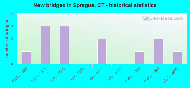
- New bridges - historical statistics
- 11920-1929
- 31930-1939
- 31940-1949
- 21960-1969
- 11980-1989
- 21990-1999
- 12000-2009
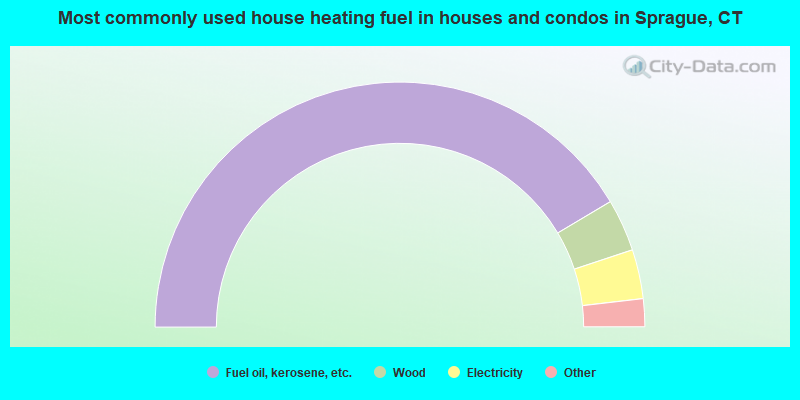
- 82.9%Fuel oil, kerosene, etc.
- 6.9%Wood
- 6.5%Electricity
- 2.4%Bottled, tank, or LP gas
- 1.2%Utility gas
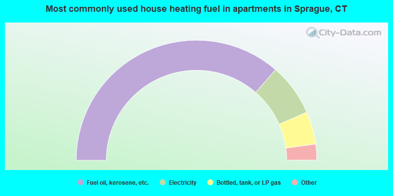
- 72.9%Fuel oil, kerosene, etc.
- 14.1%Electricity
- 8.8%Bottled, tank, or LP gas
- 2.1%Utility gas
- 2.1%Wood
Sprague compared to Connecticut state average:
- Unemployed percentage significantly below state average.
- Black race population percentage significantly below state average.
- Hispanic race population percentage significantly below state average.
- Foreign-born population percentage significantly below state average.
- Length of stay since moving in significantly above state average.
- Number of rooms per house significantly below state average.
- House age significantly below state average.
- Percentage of population with a bachelor's degree or higher below state average.
Sprague on our top lists:
- #28 on the list of "Top 101 cities with the largest percentage of people in religious group quarters (population 1,000+)"
- #16 on the list of "Top 101 counties with the lowest average weight of females"
- #28 on the list of "Top 101 counties with the highest percentage of residents that visited a dentist within the past year"
- #28 on the list of "Top 101 counties with highest percentage of residents voting for Obama (Democrat) in the 2012 Presidential Election"
- #51 on the list of "Top 101 counties with the lowest percentage of residents that drank alcohol in the past 30 days"
- #66 on the list of "Top 101 counties with the lowest percentage of residents that keep firearms around their homes"
State forum archive: