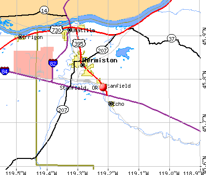
Stanfield, Oregon
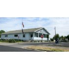
Stanfield: Stanfield Post Office, May 2009
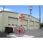
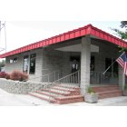
Stanfield: Stanfield Fire Dept, May 2009
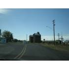
Stanfield: Grain Elevators, Stanfield, Oregon
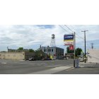
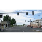
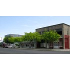
Stanfield: Stanfield Main Street, May 2009
Stanfield: Stanfield City Center, May 2009
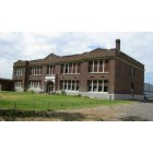
Stanfield: Stanfield High School building (not in use), May 2009
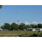
Stanfield: Stanfield, Oregon: Irrigation is very important, otherwise the area is just sagebrush.
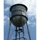
Stanfield: Stanfield water tower, May 2009
Stanfield: Stanfield Public Library, May 2009
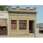
Stanfield: Stanfield Main Street & antique store, May 2009
Stanfield: Stanfield, Oregon Water Tower
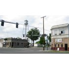
Stanfield: Stanfield City Center & water tower, May 2009
- add
your
Submit your own pictures of this city and show them to the world
- OSM Map
- General Map
- Google Map
- MSN Map
Population change since 2000: +7.7%
 |
| Males: 932 | |
| Females: 1,200 |
| Median resident age: | 41.5 years |
| Oregon median age: | 40.5 years |
Zip codes: 97875.
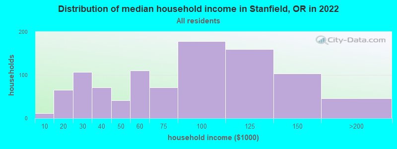
| Stanfield: | $75,285 |
| OR: | $75,657 |
Estimated per capita income in 2022: $31,119 (it was $12,842 in 2000)
Stanfield city income, earnings, and wages data
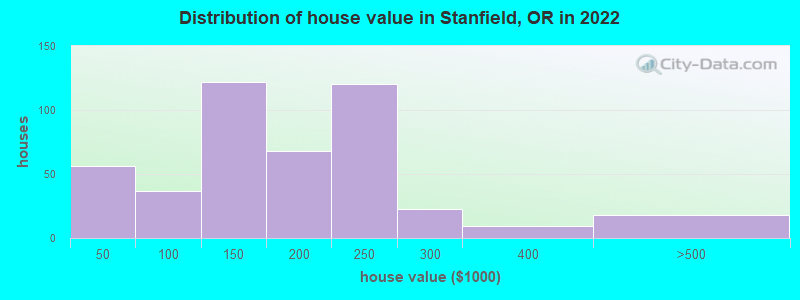
Estimated median house or condo value in 2022: $210,124 (it was $81,100 in 2000)
| Stanfield: | $210,124 |
| OR: | $475,600 |
Mean prices in 2022: all housing units: $171,182; detached houses: $175,960; mobile homes: $139,913
Median gross rent in 2022: $1,066.
(2.5% for White Non-Hispanic residents, 16.6% for Hispanic or Latino residents, 68.4% for American Indian residents, 20.0% for other race residents, 13.3% for two or more races residents)
Detailed information about poverty and poor residents in Stanfield, OR
Compare current foreclosures near Stanfield, OR:
| Photo | Address | Area | Beds / Baths | Price | Details |
|---|---|---|---|---|---|

|
#1
Deer Run Ct
Stanfield, OR 97875
|
- sq. feet
|
- baths - beds |
show details | |

|
#2
Teal Ct
Stanfield, OR 97875
|
- sq. feet
|
- baths - beds |
show details | |

|
#3
NE Oregon Ave
Irrigon, OR 97844
|
1,274 sq. feet
|
2 baths 3 beds |
show details | |

|
#4
8th St
Umatilla, OR 97882
|
1,134 sq. feet
|
1 baths 2 beds |
show details | |

|
#5
Westland Rd
Hermiston, OR 97838
|
- sq. feet
|
2 baths 2 beds |
show details | |

|
#6
W Poplar Ave
Hermiston, OR 97838
|
2,275 sq. feet
|
2 baths 6 beds |
show details | |

|
#7
Samantha St
Hermiston, OR 97838
|
1,508 sq. feet
|
2 baths 3 beds |
show details | |

|
#8
Joy Ln
Hermiston, OR 97838
|
793 sq. feet
|
1 baths 2 beds |
show details | |

|
#9
SW 23rd St
Hermiston, OR 97838
|
1,400 sq. feet
|
1 baths 3 beds |
show details | |

|
#10
NW Geer Rd
Hermiston, OR 97838
|
2,469 sq. feet
|
2 baths 4 beds |
show details |
| Photo | Address | Area | Beds / Baths | Price | Details |
|---|---|---|---|---|---|

|
#11
Agnew Rd
Hermiston, OR 97838
|
2,856 sq. feet
|
3 baths 4 beds |
show details | |

|
#12
N Hill Dr
Hermiston, OR 97838
|
1,404 sq. feet
|
2 baths 3 beds |
show details | |

|
#13
NE Montana Ave
Hermiston, OR 97838
|
1,418 sq. feet
|
3 baths 4 beds |
show details | |

|
#14
Eagle Ave
Umatilla, OR 97882
|
1,008 sq. feet
|
2 baths 3 beds |
show details | |

|
#15
Madison St
Umatilla, OR 97882
|
1,116 sq. feet
|
2 baths 3 beds |
show details | |

|
#16
Cliff St
Umatilla, OR 97882
|
1,698 sq. feet
|
2 baths 3 beds |
show details | |

|
#17
Martin Dr
Umatilla, OR 97882
|
1,500 sq. feet
|
1 baths 3 beds |
show details | |

|
#18
NW Oregon Avenue
Irrigon, OR 97844
|
- sq. feet
|
2 baths 3 beds |
show details | |

|
#19
W Poplar Ave
Hermiston, OR 97838
|
1,272 sq. feet
|
1 baths 3 beds |
show details | |

|
#20
S Edwards Rd
Hermiston, OR 97838
|
2,576 sq. feet
|
2 baths 3 beds |
show details |
| Photo | Address | Area | Beds / Baths | Price | Details |
|---|---|---|---|---|---|

|
#21
SW Joseph Ave
Hermiston, OR 97838
|
1,824 sq. feet
|
3 baths 5 beds |
show details | |

|
#22
E View Dr
Hermiston, OR 97838
|
1,448 sq. feet
|
2 baths 2 beds |
show details | |

|
#23
NE 11th Pl
Hermiston, OR 97838
|
1,821 sq. feet
|
3 baths 4 beds |
show details | |

|
#24
W Orchard Ave
Hermiston, OR 97838
|
864 sq. feet
|
1 baths 2 beds |
show details | |

|
#25
NE 11th St
Hermiston, OR 97838
|
1,353 sq. feet
|
2 baths 3 beds |
show details | |

|
#26
W Madrona Ave
Hermiston, OR 97838
|
2,579 sq. feet
|
1 baths 3 beds |
show details | |

|
#27
SW 10th Pl
Hermiston, OR 97838
|
1,868 sq. feet
|
1 baths 4 beds |
show details | |

|
#28
W Joseph Ave
Hermiston, OR 97838
|
- sq. feet
|
2 baths 3 beds |
show details | |

|
#29
Westland Rd
Hermiston, OR 97838
|
- sq. feet
|
2 baths 3 beds |
show details | |

|
#30
NE 4th St
Hermiston, OR 97838
|
- sq. feet
|
2 baths 3 beds |
show details |
| Photo | Address | Area | Beds / Baths | Price | Details |
|---|---|---|---|---|---|

|
#31
E Autumn Ave
Hermiston, OR 97838
|
- sq. feet
|
- baths - beds |
show details | |

|
#32
Orchard St
Umatilla, OR 97882
|
- sq. feet
|
- baths - beds |
show details | |

|
#33
SE 5th St # C
Hermiston, OR 97838
|
- sq. feet
|
- baths - beds |
show details | |

|
#34
Highway 207 # 35
Hermiston, OR 97838
|
- sq. feet
|
- baths - beds |
show details | |

|
#35
8th St
Umatilla, OR 97882
|
- sq. feet
|
- baths - beds |
show details | |

|
#36
John Day St
Umatilla, OR 97882
|
- sq. feet
|
- baths - beds |
show details | |

|
#37
SW Coyote Dr
Hermiston, OR 97838
|
- sq. feet
|
- baths - beds |
show details | |

|
#38
NE Emerald Dr
Hermiston, OR 97838
|
- sq. feet
|
- baths - beds |
show details | |

|
#39
E Main St
Hermiston, OR 97838
|
- sq. feet
|
- baths - beds |
show details | |

|
#40
E Main St # 104
Hermiston, OR 97838
|
- sq. feet
|
- baths - beds |
show details |
| Photo | Address | Area | Beds / Baths | Price | Details |
|---|---|---|---|---|---|

|
#41
W Sunland Ave Apt 3
Hermiston, OR 97838
|
- sq. feet
|
- baths - beds |
show details | |

|
#42
Sagebrush Rd
Hermiston, OR 97838
|
- sq. feet
|
- baths - beds |
show details | |

|
#43
NW 12th St
Hermiston, OR 97838
|
- sq. feet
|
- baths - beds |
show details | |

|
#44
N Ott Rd
Hermiston, OR 97838
|
- sq. feet
|
- baths - beds |
show details | |

|
#45
W Hartley Ave
Hermiston, OR 97838
|
- sq. feet
|
- baths - beds |
show details | |

|
#46
SW 11th St Unit 95
Hermiston, OR 97838
|
- sq. feet
|
- baths - beds |
show details | |

|
#47
NE 8th St
Hermiston, OR 97838
|
- sq. feet
|
- baths - beds |
show details | |

|
#48
NW Sjoren Ln
Hermiston, OR 97838
|
- sq. feet
|
- baths - beds |
show details | |

|
#49
Pheasant Ln
Hermiston, OR 97838
|
- sq. feet
|
- baths - beds |
show details | |

|
Check over 1 million property listings on Foreclosure.com!
|
browse all offers | |||


- 1,04248.9%White alone
- 97845.9%Hispanic
- 1175.5%Two or more races
- 170.8%American Indian alone
- 70.3%Asian alone
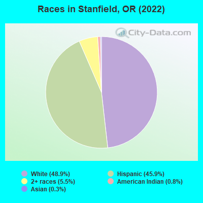
Races in Stanfield detailed stats: ancestries, foreign born residents, place of birth
According to our research of Oregon and other state lists, there was 1 registered sex offender living in Stanfield, Oregon as of April 24, 2024.
The ratio of all residents to sex offenders in Stanfield is 2,391 to 1.
The ratio of registered sex offenders to all residents in this city is near the state average.
Type |
2011 |
2012 |
2013 |
2014 |
2015 |
2016 |
2017 |
2018 |
2019 |
2020 |
2021 |
2022 |
|---|---|---|---|---|---|---|---|---|---|---|---|---|
| Murders (per 100,000) | 0 (0.0) | 0 (0.0) | 0 (0.0) | 0 (0.0) | 0 (0.0) | 0 (0.0) | 0 (0.0) | 0 (0.0) | 0 (0.0) | 0 (0.0) | 0 (0.0) | 0 (0.0) |
| Rapes (per 100,000) | 0 (0.0) | 0 (0.0) | 1 (48.6) | 0 (0.0) | 0 (0.0) | 0 (0.0) | 3 (144.0) | 1 (48.0) | 0 (0.0) | 0 (0.0) | 0 (0.0) | 0 (0.0) |
| Robberies (per 100,000) | 0 (0.0) | 0 (0.0) | 0 (0.0) | 0 (0.0) | 2 (97.8) | 2 (95.7) | 2 (96.0) | 0 (0.0) | 1 (47.8) | 0 (0.0) | 0 (0.0) | 0 (0.0) |
| Assaults (per 100,000) | 0 (0.0) | 2 (96.1) | 1 (48.6) | 0 (0.0) | 5 (244.6) | 4 (191.5) | 6 (288.0) | 2 (95.9) | 5 (238.8) | 4 (188.8) | 3 (142.0) | 3 (139.3) |
| Burglaries (per 100,000) | 0 (0.0) | 4 (192.1) | 6 (291.5) | 5 (244.3) | 8 (391.4) | 4 (191.5) | 11 (528.1) | 6 (287.8) | 12 (573.1) | 5 (236.0) | 17 (804.5) | 6 (278.7) |
| Thefts (per 100,000) | 6 (290.6) | 17 (816.5) | 19 (923.2) | 10 (488.5) | 22 (1,076) | 25 (1,197) | 33 (1,584) | 24 (1,151) | 28 (1,337) | 20 (943.8) | 19 (899.2) | 20 (928.9) |
| Auto thefts (per 100,000) | 0 (0.0) | 7 (336.2) | 4 (194.4) | 3 (146.6) | 4 (195.7) | 2 (95.7) | 5 (240.0) | 3 (143.9) | 5 (238.8) | 3 (141.6) | 2 (94.7) | 4 (185.8) |
| Arson (per 100,000) | 0 (0.0) | 0 (0.0) | 0 (0.0) | 0 (0.0) | 1 (48.9) | 2 (95.7) | 2 (96.0) | 0 (0.0) | 1 (47.8) | 3 (141.6) | 0 (0.0) | 0 (0.0) |
| City-Data.com crime index | 11.6 | 92.2 | 121.5 | 48.4 | 164.4 | 136.0 | 321.2 | 135.3 | 174.8 | 103.4 | 128.3 | 99.4 |
The City-Data.com crime index weighs serious crimes and violent crimes more heavily. Higher means more crime, U.S. average is 246.1. It adjusts for the number of visitors and daily workers commuting into cities.
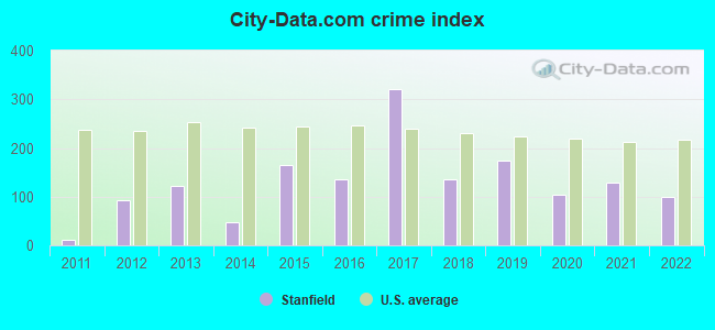
Crime rate in Stanfield detailed stats: murders, rapes, robberies, assaults, burglaries, thefts, arson
Full-time law enforcement employees in 2021, including police officers: 5 (5 officers - 4 male; 1 female).
| Officers per 1,000 residents here: | 2.37 |
| Oregon average: | 1.48 |
 Recent articles from our blog. Our writers, many of them Ph.D. graduates or candidates, create easy-to-read articles on a wide variety of topics.

 | Self Serve Gas at issue again! (145 replies) |
| Why can't you pump your own gas in Oregon? (128 replies) |
| tipping gas station attendent (19 replies) |
| best schools in Roseburg? Family friendly? (10 replies) |
| Second largest school district statewide is now half minority students. (22 replies) |
| What does anyone think of Hermiston area? (24 replies) |
Latest news from Stanfield, OR collected exclusively by city-data.com from local newspapers, TV, and radio stations
Ancestries: American (11.5%), Irish (5.0%), English (2.8%), Norwegian (2.3%), German (1.2%), Polish (1.1%).
Current Local Time: PST time zone
Incorporated in 1910
Elevation: 590 feet
Land area: 1.44 square miles.
Population density: 1,478 people per square mile (low).
367 residents are foreign born (16.6% Latin America).
| This city: | 17.2% |
| Oregon: | 9.8% |
Median real estate property taxes paid for housing units with mortgages in 2022: $1,460 (0.6%)
Median real estate property taxes paid for housing units with no mortgage in 2022: $1,322 (0.8%)
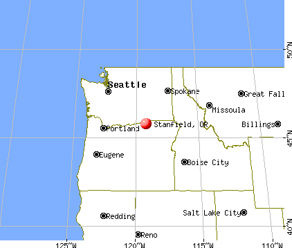
Nearest city with pop. 50,000+: Kennewick, WA  (29.4 miles , pop. 54,693).
Nearest city with pop. 200,000+: Portland, OR (166.4 miles , pop. 529,121).
Nearest city with pop. 1,000,000+: Los Angeles, CA (810.1 miles , pop. 3,694,820).
Nearest cities:
), ), Latitude: 45.78 N, Longitude: 119.22 W
Area code: 541

| Here: | 4.1% |
| Oregon: | 3.9% |
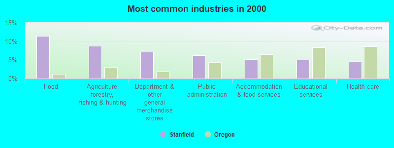
- Food (11.4%)
- Agriculture, forestry, fishing & hunting (8.8%)
- Department & other general merchandise stores (7.1%)
- Public administration (6.2%)
- Accommodation & food services (5.2%)
- Educational services (5.1%)
- Health care (4.6%)
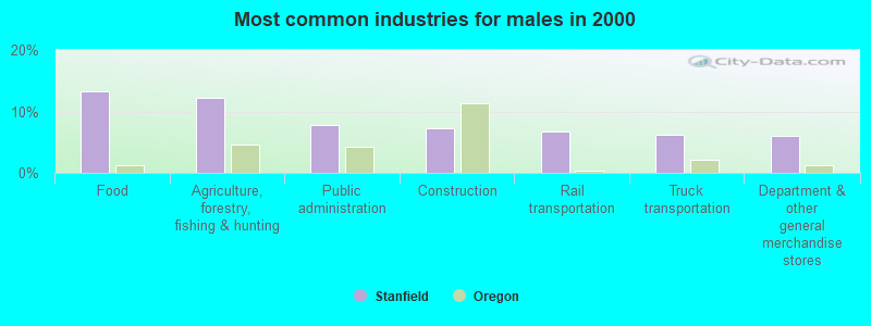
- Food (13.2%)
- Agriculture, forestry, fishing & hunting (12.2%)
- Public administration (7.8%)
- Construction (7.2%)
- Rail transportation (6.8%)
- Truck transportation (6.2%)
- Department & other general merchandise stores (6.0%)
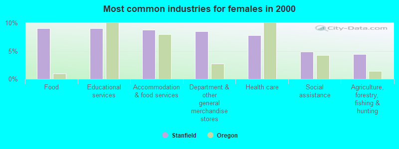
- Food (9.0%)
- Educational services (9.0%)
- Accommodation & food services (8.8%)
- Department & other general merchandise stores (8.5%)
- Health care (7.8%)
- Social assistance (4.9%)
- Agriculture, forestry, fishing & hunting (4.4%)
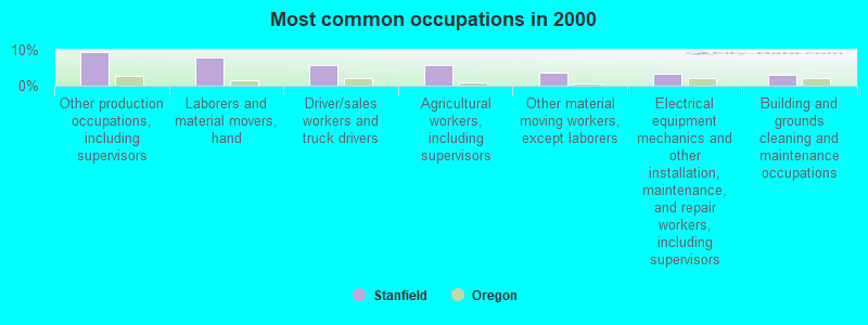
- Other production occupations, including supervisors (9.4%)
- Laborers and material movers, hand (7.9%)
- Driver/sales workers and truck drivers (5.8%)
- Agricultural workers, including supervisors (5.6%)
- Other material moving workers, except laborers (3.6%)
- Electrical equipment mechanics and other installation, maintenance, and repair workers, including supervisors (3.3%)
- Building and grounds cleaning and maintenance occupations (3.0%)
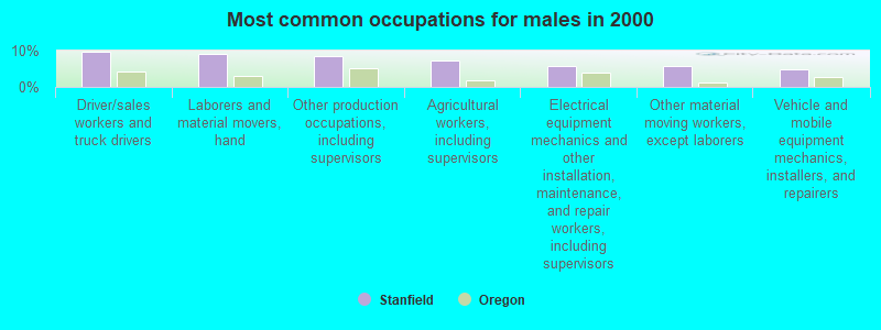
- Driver/sales workers and truck drivers (9.6%)
- Laborers and material movers, hand (9.2%)
- Other production occupations, including supervisors (8.6%)
- Agricultural workers, including supervisors (7.2%)
- Electrical equipment mechanics and other installation, maintenance, and repair workers, including supervisors (5.8%)
- Other material moving workers, except laborers (5.6%)
- Vehicle and mobile equipment mechanics, installers, and repairers (4.8%)
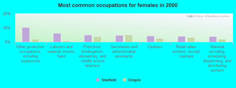
- Other production occupations, including supervisors (10.3%)
- Laborers and material movers, hand (6.2%)
- Preschool, kindergarten, elementary, and middle school teachers (4.9%)
- Secretaries and administrative assistants (4.7%)
- Cashiers (4.4%)
- Retail sales workers, except cashiers (4.1%)
- Material recording, scheduling, dispatching, and distributing workers (3.9%)
Average climate in Stanfield, Oregon
Based on data reported by over 4,000 weather stations


|
|


(lower is better)
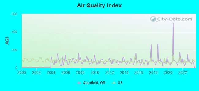
Air Quality Index (AQI) level in 2023 was 54.9. This is better than average.
| City: | 54.9 |
| U.S.: | 72.6 |
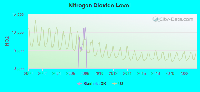
Nitrogen Dioxide (NO2) [ppb] level in 2007 was 7.16. This is significantly worse than average. Closest monitor was 4.0 miles away from the city center.
| City: | 7.16 |
| U.S.: | 5.11 |
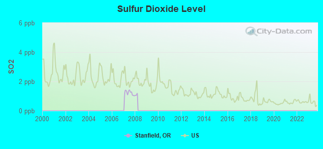
Sulfur Dioxide (SO2) [ppb] level in 2007 was 1.22. This is better than average. Closest monitor was 4.0 miles away from the city center.
| City: | 1.22 |
| U.S.: | 1.51 |
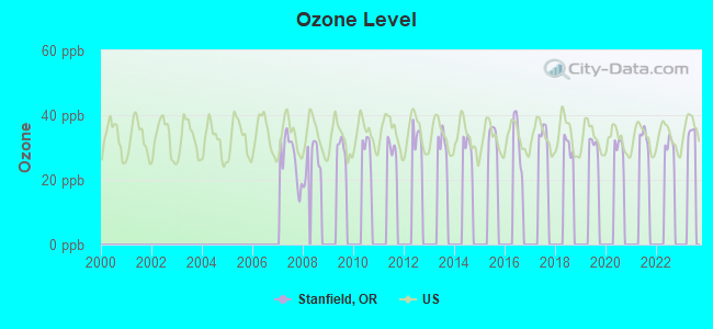
Ozone [ppb] level in 2008 was 26.3. This is better than average. Closest monitor was 4.0 miles away from the city center.
| City: | 26.3 |
| U.S.: | 33.3 |
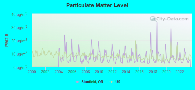
Particulate Matter (PM2.5) [µg/m3] level in 2023 was 4.55. This is significantly better than average. Closest monitor was 4.0 miles away from the city center.
| City: | 4.55 |
| U.S.: | 8.11 |
Earthquake activity:
Stanfield-area historical earthquake activity is significantly above Oregon state average. It is 1332% greater than the overall U.S. average.On 4/13/1949 at 19:55:42, a magnitude 7.0 (7.0 UK, Class: Major, Intensity: VIII - XII) earthquake occurred 186.4 miles away from Stanfield center, causing $80,000,000 total damage
On 10/28/1983 at 14:06:06, a magnitude 7.3 (6.2 MB, 7.3 MS, 7.0 MW) earthquake occurred 290.1 miles away from Stanfield center, causing 2 deaths (2 shaking deaths) and 3 injuries, causing $15,000,000 total damage
On 2/28/2001 at 18:54:32, a magnitude 6.8 (6.5 MB, 6.6 MS, 6.8 MW, Class: Strong, Intensity: VII - IX) earthquake occurred 184.1 miles away from Stanfield center, causing $2,000,000,000 total damage and $305,000,000 insured losses
On 2/28/2001 at 18:54:32, a magnitude 6.8 (6.8 MD, Depth: 32.2 mi) earthquake occurred 192.1 miles away from the city center
On 10/3/1915 at 06:52:48, a magnitude 7.6 (7.6 UK) earthquake occurred 375.4 miles away from the city center
On 4/29/1965 at 15:28:43, a magnitude 6.6 (6.6 UK) earthquake occurred 182.3 miles away from the city center, causing $28,000,000 total damage
Magnitude types: body-wave magnitude (MB), duration magnitude (MD), surface-wave magnitude (MS), moment magnitude (MW)
Natural disasters:
The number of natural disasters in Umatilla County (10) is smaller than the US average (15).Major Disasters (Presidential) Declared: 5
Emergencies Declared: 2
Causes of natural disasters: Floods: 5, Storms: 3, Landslides: 2, Mudslides: 2, Winter Storms: 2, Drought: 1, Fire: 1, Heavy Rain: 1, Hurricane: 1, Other: 1 (Note: some incidents may be assigned to more than one category).

Hospitals and medical centers near Stanfield:
- VANGE JOHN MEMORIAL HOSPICE (Hospital, about 6 miles away; HERMISTON, OR)
- HERMISTON GOOD SAMARITAN (Nursing Home, about 6 miles away; HERMISTON, OR)
- REGENCY HERMISTON NURSING AND REHAB CENTER (Nursing Home, about 6 miles away; HERMISTON, OR)
- GOOD SHEPHERD MEDICAL CENTER Critical Access Hospitals (about 7 miles away; HERMISTON, OR)
- HERMISTON COMMUNITY DIALYSIS CENTER (Dialysis Facility, about 7 miles away; HERMISTON, OR)
- TLC HOME HEALTH (Home Health Center, about 7 miles away; HERMISTON, OR)
Colleges/universities with over 2000 students nearest to Stanfield:
- Columbia Basin College (about 33 miles; Pasco, WA; Full-time enrollment: 5,111)
- Walla Walla Community College (about 50 miles; Walla Walla, WA; FT enrollment: 4,263)
- Eastern Oregon University (about 64 miles; La Grande, OR; FT enrollment: 3,127)
- Yakima Valley Community College (about 84 miles; Yakima, WA; FT enrollment: 3,632)
- Central Washington University (about 106 miles; Ellensburg, WA; FT enrollment: 10,960)
- Lewis-Clark State College (about 114 miles; Lewiston, ID; FT enrollment: 3,199)
- Washington State University (about 119 miles; Pullman, WA; FT enrollment: 25,055)
Public high school in Stanfield:
- STANFIELD SECONDARY SCHOOL (Students: 249, Location: 1100 N MAIN, Grades: 7-12)
Public elementary/middle school in Stanfield:
- STANFIELD ELEMENTARY SCHOOL (Students: 314, Location: 1120 N MAIN ST, Grades: KG-6)
Points of interest:
Notable locations in Stanfield: Stanfield Wastewater Treatment Facility (A), Stanfield Municipal Court (B), Stanfield City Hall (C), Stanfield Public Library (D), Stanfield Fire Department (E), Stanfield Public Works Department (F). Display/hide their locations on the map
Parks in Stanfield include: Bard Park (1), Charlotte Rauch Park (2), Stanfield Heights Park (3). Display/hide their locations on the map
| This city: | 3.0 people |
| Oregon: | 2.5 people |
| This city: | 75.2% |
| Whole state: | 63.4% |
| This city: | 9.8% |
| Whole state: | 8.0% |
Likely homosexual households (counted as self-reported same-sex unmarried-partner households)
- Lesbian couples: 0.1% of all households
- Gay men: 0.1% of all households
Banks with branches in Stanfield (2011 data):
- Banner Bank: Stanfield Branch at 100 South Main Street, branch established on 1979/07/16. Info updated 2011/05/03: Bank assets: $4,048.2 mil, Deposits: $3,348.4 mil, headquarters in Walla Walla, WA, positive income, Commercial Lending Specialization, 87 total offices, Holding Company: Banner Corporation
For population 15 years and over in Stanfield:
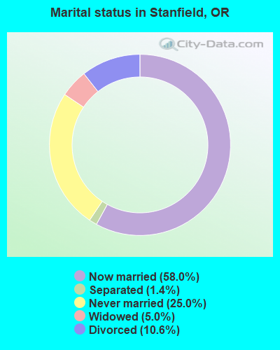
- Never married: 25.0%
- Now married: 58.0%
- Separated: 1.4%
- Widowed: 5.0%
- Divorced: 10.6%
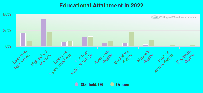
For population 25 years and over in Stanfield:
- High school or higher: 78.1%
- Bachelor's degree or higher: 8.3%
- Graduate or professional degree: 3.0%
- Unemployed: 8.2%
- Mean travel time to work (commute): 17.7 minutes
| Here: | 16.4 |
| Oregon average: | 11.6 |
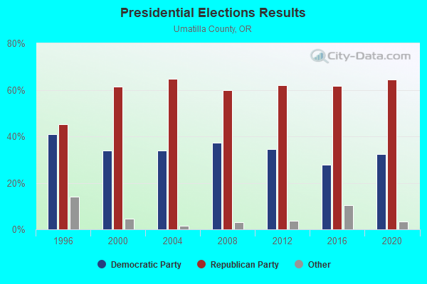
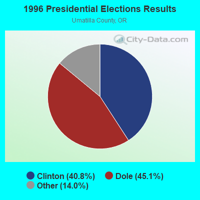

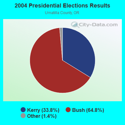
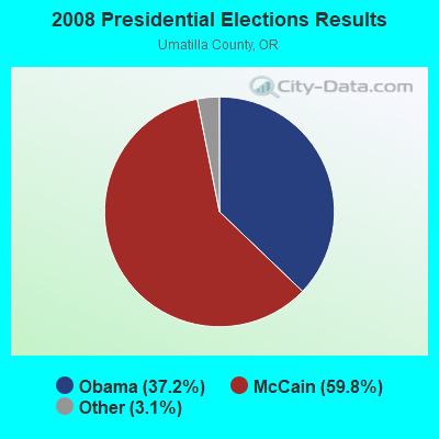

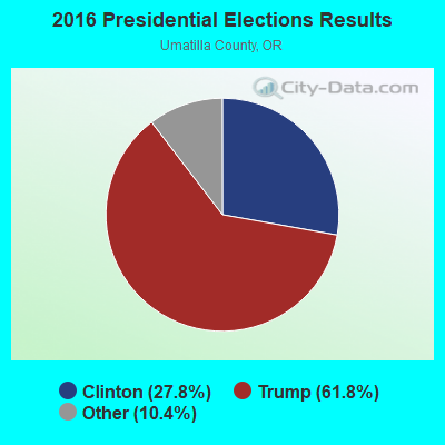
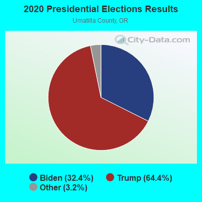
Graphs represent county-level data. Detailed 2008 Election Results
Religion statistics for Stanfield, OR (based on Umatilla County data)
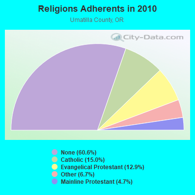
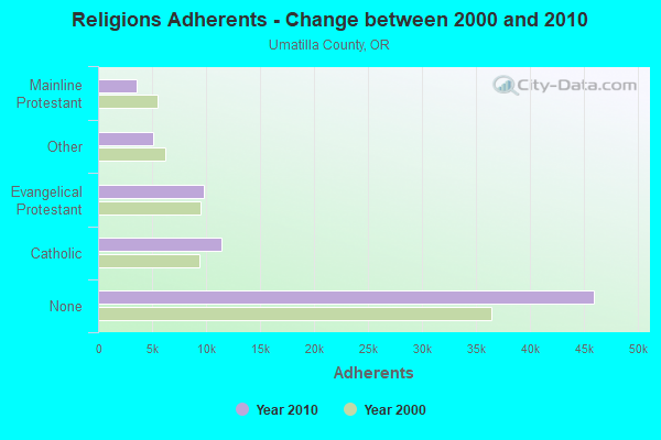
| Religion | Adherents | Congregations |
|---|---|---|
| Catholic | 11,402 | 6 |
| Evangelical Protestant | 9,816 | 75 |
| Other | 5,107 | 17 |
| Mainline Protestant | 3,575 | 24 |
| None | 45,989 | - |
Food Environment Statistics:
| Umatilla County: | 2.18 / 10,000 pop. |
| Oregon: | 2.03 / 10,000 pop. |
| Umatilla County: | 0.55 / 10,000 pop. |
| Oregon: | 0.33 / 10,000 pop. |
| Here: | 1.78 / 10,000 pop. |
| Oregon: | 2.01 / 10,000 pop. |
| This county: | 1.91 / 10,000 pop. |
| Oregon: | 1.69 / 10,000 pop. |
| This county: | 7.92 / 10,000 pop. |
| Oregon: | 9.93 / 10,000 pop. |
| This county: | 7.8% |
| Oregon: | 7.4% |
| Umatilla County: | 32.4% |
| Oregon: | 25.6% |
| Umatilla County: | 16.9% |
| Oregon: | 14.2% |
Health and Nutrition:
| Stanfield: | 45.0% |
| Oregon: | 49.6% |
| Here: | 41.3% |
| Oregon: | 46.8% |
| Here: | 28.5 |
| Oregon: | 28.5 |
| This city: | 24.7% |
| Oregon: | 21.2% |
| This city: | 10.0% |
| Oregon: | 10.1% |
| This city: | 6.7 |
| Oregon: | 6.8 |
| This city: | 30.7% |
| State: | 33.3% |
| This city: | 52.4% |
| Oregon: | 56.5% |
| Stanfield: | 78.5% |
| Oregon: | 78.7% |
More about Health and Nutrition of Stanfield, OR Residents
| Local government employment and payroll (March 2022) | |||||
| Function | Full-time employees | Monthly full-time payroll | Average yearly full-time wage | Part-time employees | Monthly part-time payroll |
|---|---|---|---|---|---|
| Police Protection - Officers | 5 | $26,517 | $63,641 | 0 | $0 |
| Other Government Administration | 2 | $11,699 | $70,194 | 7 | $335 |
| Sewerage | 2 | $9,181 | $55,086 | 0 | $0 |
| Local Libraries | 1 | $3,852 | $46,224 | 2 | $3,545 |
| Water Supply | 1 | $7,119 | $85,428 | 0 | $0 |
| Parks and Recreation | 1 | $6,522 | $78,264 | 0 | $0 |
| Judicial and Legal | 1 | $6,013 | $72,156 | 2 | $758 |
| Streets and Highways | 0 | $0 | 1 | $2,674 | |
| Financial Administration | 0 | $0 | 1 | $3,646 | |
| Totals for Government | 13 | $70,905 | $65,451 | 13 | $10,958 |
Stanfield government finances - Expenditure in 2017 (per resident):
- Construction - Water Utilities: $303,000 ($142.12)
Regular Highways: $71,000 ($33.30)
Parks and Recreation: $27,000 ($12.66)
Police Protection: $17,000 ($7.97)
Libraries: $1,000 ($0.47)
- Current Operations - Police Protection: $392,000 ($183.86)
Water Utilities: $294,000 ($137.90)
Sewerage: $238,000 ($111.63)
Solid Waste Management: $206,000 ($96.62)
Parks and Recreation: $169,000 ($79.27)
Regular Highways: $167,000 ($78.33)
Central Staff Services: $97,000 ($45.50)
Libraries: $96,000 ($45.03)
Judicial and Legal Services: $57,000 ($26.74)
- General - Interest on Debt: $60,000 ($28.14)
- Intergovernmental to Local - Other - Police Protection: $16,000 ($7.50)
- Other Capital Outlay - Parks and Recreation: $24,000 ($11.26)
- Total Salaries and Wages: $392,000 ($183.86)
Stanfield government finances - Revenue in 2017 (per resident):
- Charges - Sewerage: $432,000 ($202.63)
Solid Waste Management: $182,000 ($85.37)
- Local Intergovernmental - Other: $48,000 ($22.51)
- Miscellaneous - General Revenue - Other: $81,000 ($37.99)
Fines and Forfeits: $37,000 ($17.35)
Rents: $8,000 ($3.75)
Donations From Private Sources: $4,000 ($1.88)
Interest Earnings: $1,000 ($0.47)
Sale of Property: $1,000 ($0.47)
- Revenue - Water Utilities: $381,000 ($178.71)
- State Intergovernmental - Water Utilities: $232,000 ($108.82)
General Local Government Support: $181,000 ($84.90)
Highways: $108,000 ($50.66)
Other: $1,000 ($0.47)
- Tax - Property: $190,000 ($89.12)
Motor Fuels Sales: $169,000 ($79.27)
Public Utilities Sales: $84,000 ($39.40)
Other License: $40,000 ($18.76)
Stanfield government finances - Debt in 2017 (per resident):
- Long Term Debt - Beginning Outstanding - Unspecified Public Purpose: $1,160,000 ($544.09)
Outstanding Unspecified Public Purpose: $1,020,000 ($478.42)
Retired Unspecified Public Purpose: $140,000 ($65.67)
Stanfield government finances - Cash and Securities in 2017 (per resident):
- Other Funds - Cash and Securities: $650,000 ($304.88)
Businesses in Stanfield, OR
- FedEx: 1
- McDonald's: 1
- UPS: 1
Strongest AM radio stations in Stanfield:
- KOHU (1360 AM; 4 kW; HERMISTON, OR; Owner: WESTEND RADIO, LLC)
- KLWJ (1090 AM; daytime; 2 kW; UMATILLA, OR; Owner: UMATILLA BROADCASTING, INC.)
- KFLD (870 AM; 10 kW; PASCO, WA; Owner: CAPSTAR TX LIMITED PARTNERSHIP)
- KONA (610 AM; 5 kW; KENNEWICK-RICHLAND-P, WA; Owner: COMMONWEALTH LICENSE SUBSIDIARY, LLC)
- KUMA (1290 AM; 5 kW; PENDLETON, OR; Owner: ROUND-UP RADIO, INC.)
- KALE (960 AM; 5 kW; RICHLAND, WA; Owner: NEW NORTHWEST BROADCASTERS, LLC)
- KTBI (810 AM; daytime; 50 kW; EPHRATA, WA; Owner: TACOMA BROADCASTERS, INCORPORATED)
- KPOJ (620 AM; 50 kW; PORTLAND, OR; Owner: CITICASTERS LICENSES, L.P.)
- KZTS (1210 AM; 10 kW; SUNNYSIDE, WA; Owner: BUTTERFIELD BROADCASTING CORPORATION)
- KXL (750 AM; 50 kW; PORTLAND, OR; Owner: ROSE CITY RADIO CORPORATION)
- KTIX (1240 AM; 1 kW; PENDLETON, OR; Owner: KSRV, INC.)
- KPAM (860 AM; 50 kW; TROUTDALE, OR; Owner: PAMPLIN BROADCASTING-OREGON, INC.)
- KZXR (1310 AM; 5 kW; PROSSER, WA; Owner: MOON BROADCASTING PROSSER LLC)
Strongest FM radio stations in Stanfield:
- KONA-FM (105.3 FM; KENNEWICK, WA; Owner: COMMONWEALTH LICENSE SUBSIDIARY, LLC)
- KQFM (100.5 FM; HERMISTON, OR; Owner: WESTEND RADIO, LLC)
- KFAE-FM (89.1 FM; RICHLAND, WA; Owner: WASHINGTON STATE UNIVERSITY)
- KEYW (98.3 FM; PASCO, WA; Owner: CAPSTAR TX LIMITED PARTNERSHIP)
- KORD-FM (102.7 FM; RICHLAND, WA; Owner: CAPSTAR TX LIMITED PARTNERSHIP)
- KEGX (106.5 FM; RICHLAND, WA; Owner: NEW NORTHWEST BROADCASTERS, LLC)
- KOLU (90.1 FM; PASCO, WA; Owner: RIVERVIEW BAPTIST CHRISTIAN SCHOOLS)
- K261CG (100.1 FM; PASCO, WA; Owner: NORTHWEST CHICANO RADIO NETWORK)
- KBLD (91.7 FM; KENNEWICK, WA; Owner: CSN INTERNATIONAL)
- KGSG (93.7 FM; PASCO, WA; Owner: GOSPEL MUSIC BROADCASTING CORP.)
- KGDN (101.3 FM; PASCO, WA; Owner: WEST PASCO FINE ARTS RADIO)
- K204CZ (88.7 FM; KENNEWICK, WA; Owner: CALVARY CHAPEL OF TWIN FALLS, INC.)
- KRBM (90.9 FM; PENDLETON, OR; Owner: OREGON PUBLIC BROADCASTING)
- KOLW (97.9 FM; MILTON-FREEWATER, OR; Owner: CAPSTAR TX LIMITED PARTNERSHIP)
- KUJ-FM (99.1 FM; WALLA WALLA, WA; Owner: ALEXANDRA COMMUNICATIONS)
- KXRX (97.1 FM; WALLA WALLA, WA; Owner: CAPSTAR TX LIMITED PARTNERSHIP)
- KIOK (94.9 FM; RICHLAND, WA; Owner: NEW NORTHWEST BROADCASTERS, LLC)
- KUMA-FM (107.7 FM; PENDLETON, OR; Owner: ROUND-UP RADIO, INC.)
- KRKL (93.3 FM; WALLA WALLA, WA; Owner: EDUCATIONAL MEDIA FOUNDATION)
- K204DH (88.7 FM; HANFORD, WA; Owner: CALVARY CHAPEL OF TWIN FALLS, INC.)
TV broadcast stations around Stanfield:
- KEPR-TV (Channel 19; PASCO, WA; Owner: FISHER BROADCASTING - WASHINGTON TV, L.L.C.)
Stanfield fatal accident list:
Mar 24, 1997 07:10 PM, 395/Odot54, Vehicles: 2, Persons: 3, Fatalities: 1, Drunk persons involved: 1
May 30, 1982 02:51 AM, Hardingne, Vehicles: 1, Persons: 1, Fatalities: 1, Drunk persons involved: 1
Jun 5, 1977 04:50 AM, Vehicles: 1, Persons: 3, Fatalities: 1, Drunk persons involved: 1
Jul 22, 1976 04:30 PM, Vehicles: 1, Persons: 1, Fatalities: 1
Jul 22, 1975 04:30 PM, Vehicles: 1, Persons: 1, Fatalities: 1
- National Bridge Inventory (NBI) Statistics
- 30Number of bridges
- 308ft / 93.7mTotal length
- $2,449,000Total costs
- 100,675Total average daily traffic
- 24,095Total average daily truck traffic
- New bridges - historical statistics
- 11920-1929
- 21950-1959
- 81960-1969
- 91980-1989
- 51990-1999
- 42000-2009
- 12010-2019
FCC Registered Antenna Towers:
14 (See the full list of FCC Registered Antenna Towers in Stanfield)FCC Registered Broadcast Land Mobile Towers:
8 (See the full list of FCC Registered Broadcast Land Mobile Towers in Stanfield, OR)FCC Registered Microwave Towers:
5- STATION, Stanfield Meter Station (Lat: 45.828167 Lon: -119.138056), Overall height: 9.1 m, Call Sign: WNEN488,
Assigned Frequencies: 6695.00 MHz, Grant Date: 06/12/2009, Expiration Date: 06/30/2019, Cancellation Date: 10/04/2018, Registrant: Gas Transmission Northwest Corporation, 5250 Corporate Drive, Troy, MI 48098, Phone: (248) 205-4520, Fax: (248) 205-4620, Email:
- Stahl Farms, Unnamed Road (Lat: 45.823889 Lon: -119.085222), Type: Building, Structure height: 18.3 m, Call Sign: WQNK485,
Assigned Frequencies: 17965.0 MHz, 17965.0 MHz, Grant Date: 06/15/2021, Expiration Date: 03/03/2031, Certifier: Faisal Nisar, Registrant: Blue Mountain Networks LLC, 219 Main Street, Chatham, NJ 07928, Phone: (212) 653-0343, Email:
- STANFIELD, 34120 Stage Gulch Rd (Echo #43178) (Lat: 45.762639 Lon: -119.183667), Type: Mast, Structure height: 53.6 m, Overall height: 56.4 m, Call Sign: WQUA635,
Assigned Frequencies: 6226.89 MHz, 6286.19 MHz, 6226.89 MHz, 6226.89 MHz, 6226.89 MHz, 6226.89 MHz, 6226.89 MHz, 6286.19 MHz, 6286.19 MHz, 6286.19 MHz, 6286.19 MHz, 6286.19 MHz, Grant Date: 05/21/2014, Expiration Date: 05/21/2024, Certifier: Gregory M Romano, Registrant: Verizon, 5055 Northpointe Pkwy, Alpharetta, GA 30022, Phone: (770) 797-1070, Email:
- Piercy Farm, Farm At Despain Gulch Road (Lat: 45.790278 Lon: -119.058861), Type: Pole, Structure height: 8 m, Overall height: 9 m, Call Sign: WRMY201,
Assigned Frequencies: 11075.0 MHz, 11075.0 MHz, 11075.0 MHz, 11075.0 MHz, 11075.0 MHz, 11075.0 MHz, 11075.0 MHz, 11075.0 MHz, Grant Date: 06/22/2021, Expiration Date: 06/22/2031, Certifier: Darnell Nickerson, Registrant: Intelpath, Hinsdale, IL 60522, Phone: (312) 841-9188, Email:
- STATION, Railroad Mp 188.63 (Lat: 45.781500 Lon: -119.224722), Overall height: 18.3 m, Call Sign: WED820,
Assigned Frequencies: 12340.0 MHz, Grant Date: 01/28/1993, Expiration Date: 01/28/1998, Cancellation Date: 01/11/1995, Phone: (402) 271-3700
FCC Registered Amateur Radio Licenses:
12 (See the full list of FCC Registered Amateur Radio Licenses in Stanfield)FAA Registered Aircraft:
14 (See the full list of FAA Registered Aircraft in Stanfield)2002 - 2018 National Fire Incident Reporting System (NFIRS) incidents
- Fire incident types reported to NFIRS in Stanfield, OR
- 21662.4%Outside Fires
- 7622.0%Structure Fires
- 5315.3%Mobile Property/Vehicle Fires
- 10.3%Other
 According to the data from the years 2002 - 2018 the average number of fires per year is 20. The highest number of fires - 39 took place in 2005, and the least - 1 in 2017. The data has a dropping trend.
 When looking into fire subcategories, the most reports belonged to: Outside Fires (62.4%), and Structure Fires (22.0%).
| Most common first names in Stanfield, OR among deceased individuals | ||
| Name | Count | Lived (average) |
|---|---|---|
| William | 13 | 79.0 years |
| John | 12 | 71.5 years |
| James | 12 | 74.5 years |
| Frank | 9 | 83.2 years |
| Betty | 7 | 74.4 years |
| Charles | 6 | 80.6 years |
| Mary | 6 | 66.5 years |
| Ralph | 6 | 77.8 years |
| Robert | 6 | 70.1 years |
| Glenn | 5 | 66.4 years |
| Most common last names in Stanfield, OR among deceased individuals | ||
| Last name | Count | Lived (average) |
|---|---|---|
| Rueber | 6 | 75.5 years |
| Brown | 5 | 73.6 years |
| Bartley | 5 | 77.4 years |
| Krause | 5 | 83.8 years |
| Stewart | 5 | 68.2 years |
| Martin | 4 | 78.5 years |
| Seibel | 4 | 69.3 years |
| Wheeler | 4 | 74.8 years |
| Dyer | 3 | 76.4 years |
| Johnson | 3 | 70.3 years |
- 49.9%Electricity
- 41.8%Utility gas
- 5.7%Wood
- 1.1%Other fuel
- 1.0%Fuel oil, kerosene, etc.
- 0.5%Bottled, tank, or LP gas
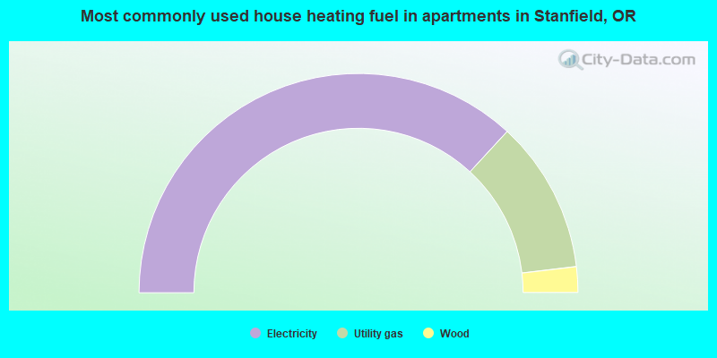
- 73.7%Electricity
- 22.5%Utility gas
- 3.8%Wood
Stanfield compared to Oregon state average:
- Median house value significantly below state average.
- Unemployed percentage below state average.
- Black race population percentage significantly below state average.
- Hispanic race population percentage significantly above state average.
- Median age below state average.
- Foreign-born population percentage above state average.
- Length of stay since moving in above state average.
- Number of college students significantly below state average.
- Percentage of population with a bachelor's degree or higher significantly below state average.