Tuskegee-Milstead, Alabama
Submit your own pictures of this place and show them to the world
- OSM Map
- Google Map
- MSN Map
| Males: 6,379 | |
| Females: 7,717 |
| Median resident age: | 28.5 years |
| Alabama median age: | 35.8 years |
Zip code: 36083
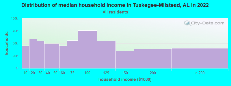
| Tuskegee-Milstead: | $39,740 |
| AL: | $59,674 |
Estimated per capita income in 2022: $21,200 (it was $12,785 in 2000)
Tuskegee-Milstead CCD income, earnings, and wages data
Estimated median house or condo value in 2022: $111,005 (it was $64,500 in 2000)
| Tuskegee-Milstead: | $111,005 |
| AL: | $200,900 |
Mean prices in 2022: all housing units: $157,687; detached houses: $181,653; townhouses or other attached units: $118,085; mobile homes: $67,686
Tuskegee-Milstead, AL residents, houses, and apartments details
Detailed information about poverty and poor residents in Tuskegee-Milstead, AL
Compare current foreclosures near your location:
| Photo | Address | Area | Beds / Baths | Price | Details |
|---|---|---|---|---|---|

|
#1
S High St
Columbus, OH 43207
|
1,678 sq. feet
|
2 baths 4 beds |
$31,900
|
show details |

|
#2
Bayberry Cir
Columbus, OH 43207
|
1,564 sq. feet
|
1 baths 3 beds |
$127,500
|
show details |

|
#3
E 21st Ave
Columbus, OH 43211
|
1,061 sq. feet
|
1 baths 3 beds |
$187,900
|
show details |

|
#4
Meadowbrook Dr
Columbus, OH 43207
|
1,752 sq. feet
|
2 baths 4 beds |
show details | |

|
#5
Bretton Pl
Columbus, OH 43211
|
1,056 sq. feet
|
1 baths 3 beds |
show details | |

|
#6
S Richardson Ave
Columbus, OH 43204
|
1,520 sq. feet
|
2 baths 3 beds |
show details | |

|
#7
Fergus Rd
Grove City, OH 43123
|
3,312 sq. feet
|
2 baths 4 beds |
show details | |

|
#8
High Free Pike
West Jefferson, OH 43162
|
1,216 sq. feet
|
2 baths 4 beds |
show details | |

|
#9
S Chillicothe St
Plain City, OH 43064
|
1,736 sq. feet
|
2 baths 4 beds |
show details | |

|
#10
Kingsglen Dr
Grove City, OH 43123
|
1,635 sq. feet
|
2 baths 4 beds |
show details |
| Photo | Address | Area | Beds / Baths | Price | Details |
|---|---|---|---|---|---|

|
#11
Derrer Rd -872
Columbus, OH 43204
|
1,667 sq. feet
|
2 baths 5 beds |
show details | |

|
#12
Mink St SW
Pataskala, OH 43062
|
1,442 sq. feet
|
1 baths 3 beds |
show details | |

|
#13
Hiawatha Park Dr
Columbus, OH 43211
|
1,278 sq. feet
|
1 baths 4 beds |
show details | |

|
#14
Rosewood Ct
Powell, OH 43065
|
2,801 sq. feet
|
3 baths 4 beds |
show details | |

|
#15
Ferris Rd
Columbus, OH 43224
|
2,218 sq. feet
|
3 baths 3 beds |
show details | |

|
#16
N Roys Ave
Columbus, OH 43204
|
1,248 sq. feet
|
2 baths 3 beds |
show details | |

|
#17
Falls Peak Ln
Delaware, OH 43015
|
1,352 sq. feet
|
2 baths 2 beds |
show details | |

|
#18
Midland Ave
Columbus, OH 43223
|
1,518 sq. feet
|
1 baths 2 beds |
show details | |

|
#19
Elaine Rd
Columbus, OH 43213
|
764 sq. feet
|
1 baths 2 beds |
show details | |

|
#20
Vineyard Haven Loop
Dublin, OH 43016
|
4,625 sq. feet
|
4 baths 4 beds |
show details |
| Photo | Address | Area | Beds / Baths | Price | Details |
|---|---|---|---|---|---|

|
#21
Wrexham Ave
Columbus, OH 43223
|
1,235 sq. feet
|
1 baths 3 beds |
show details | |

|
#22
Bunch Flower Ct
Westerville, OH 43082
|
3,173 sq. feet
|
2 baths 4 beds |
show details | |

|
#23
Mayflower Blvd
Columbus, OH 43213
|
1,591 sq. feet
|
2 baths 4 beds |
show details | |

|
#24
S Hague Ave
Columbus, OH 43204
|
979 sq. feet
|
1 baths 2 beds |
show details | |

|
#25
Arborlee Dr
Reynoldsburg, OH 43068
|
1,263 sq. feet
|
2 baths 3 beds |
show details | |

|
#26
Brookstone Dr
Westerville, OH 43082
|
1,783 sq. feet
|
3 baths 3 beds |
show details | |

|
#27
N Grener Ave
Columbus, OH 43228
|
1,120 sq. feet
|
1 baths 3 beds |
show details | |

|
#28
Bernadette Rd
Columbus, OH 43204
|
1,168 sq. feet
|
1 baths 3 beds |
show details | |

|
#29
Sleeping Meadow Dr
New Albany, OH 43054
|
3,211 sq. feet
|
2 baths 4 beds |
show details | |

|
#30
Belle Oak Dr
Galloway, OH 43119
|
1,296 sq. feet
|
2 baths 3 beds |
show details |
| Photo | Address | Area | Beds / Baths | Price | Details |
|---|---|---|---|---|---|

|
#31
Scottwood Rd
Columbus, OH 43227
|
1,008 sq. feet
|
1 baths 3 beds |
show details | |

|
#32
Fahlander Dr N
Columbus, OH 43229
|
1,338 sq. feet
|
2 baths 3 beds |
show details | |

|
#33
Stoneybrook Blvd # 21a
Hilliard, OH 43026
|
1,231 sq. feet
|
2 baths 3 beds |
show details | |

|
#34
Marshrun Dr
Grove City, OH 43123
|
2,036 sq. feet
|
2 baths 4 beds |
show details | |

|
#35
Spohn Dr
Westerville, OH 43081
|
1,040 sq. feet
|
1 baths 3 beds |
show details | |

|
#36
E Kanawha Ave
Columbus, OH 43214
|
1,230 sq. feet
|
1 baths 3 beds |
show details | |

|
#37
Oreily Dr
Galloway, OH 43119
|
1,533 sq. feet
|
2 baths 3 beds |
show details | |

|
#38
Pendent Ln
Columbus, OH 43207
|
1,260 sq. feet
|
2 baths 3 beds |
show details | |

|
#39
Conway Dr
Columbus, OH 43227
|
1,232 sq. feet
|
1 baths 3 beds |
show details | |

|
#40
Barthel Ave
Columbus, OH 43227
|
1,276 sq. feet
|
1 baths 3 beds |
show details |
| Photo | Address | Area | Beds / Baths | Price | Details |
|---|---|---|---|---|---|

|
#41
Ridgebury Dr
Hilliard, OH 43026
|
832 sq. feet
|
1 baths 2 beds |
show details | |

|
#42
Sandpiper Dr
Orient, OH 43146
|
2,219 sq. feet
|
2 baths 4 beds |
show details | |

|
#43
Leap Rd
Hilliard, OH 43026
|
1,352 sq. feet
|
1 baths 3 beds |
show details | |

|
#44
Messner Dr
Hilliard, OH 43026
|
832 sq. feet
|
1 baths 2 beds |
show details | |

|
#45
Illinois Ave
Westerville, OH 43081
|
1,120 sq. feet
|
1 baths 3 beds |
show details | |

|
#46
Mango Ln
Hilliard, OH 43026
|
1,024 sq. feet
|
1 baths 2 beds |
show details | |

|
#47
Tea Party Pl
Columbus, OH 43207
|
1,176 sq. feet
|
2 baths 3 beds |
show details | |

|
#48
Maroon Dr
Powell, OH 43065
|
1,198 sq. feet
|
2 baths 3 beds |
show details | |

|
#49
Windy Hill Ln
Galloway, OH 43119
|
1,108 sq. feet
|
2 baths 3 beds |
show details | |

|
Check over 1 million property listings on Foreclosure.com!
|
browse all offers | |||

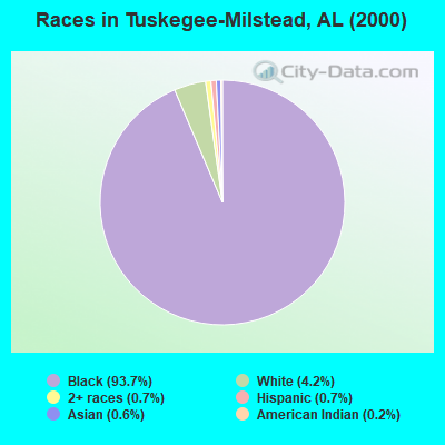
- 14,27993.7%Black alone
- 6344.2%White alone
- 1090.7%Two or more races
- 1020.7%Hispanic
- 870.6%Asian alone
- 250.2%American Indian alone
- 100.07%Other race alone
- 10.01%Native Hawaiian and Other
Pacific Islander alone
 Recent articles from our blog. Our writers, many of them Ph.D. graduates or candidates, create easy-to-read articles on a wide variety of topics.
Current Local Time: CST time zone
Land area: 107.6 square miles.
Population density: 131 people per square mile (very low).
| Tuskegee-Milstead CCD: | 0.4% ($241) |
| Alabama: | 0.4% ($289) |
Nearest city with pop. 50,000+: Montgomery, AL  (32.7 miles , pop. 201,568).
Nearest city with pop. 1,000,000+: Houston, TX (600.7 miles , pop. 1,953,631).
Nearest cities:
), ), ), ), )Latitude: 32.43 N, Longitude: 85.73 W
Area code commonly used in this area: 334
| Here: | 3.2% |
| Alabama: | 2.6% |
- Educational services (24.6%)
- Health care (19.5%)
- Public administration (8.2%)
- Accommodation & food services (7.3%)
- Construction (3.8%)
- Food & beverage stores (3.0%)
- Arts, entertainment, recreation (2.3%)
- Educational services (23.0%)
- Health care (12.1%)
- Public administration (9.3%)
- Construction (7.8%)
- Accommodation & food services (5.5%)
- Food & beverage stores (3.9%)
- Arts, entertainment, recreation (2.8%)
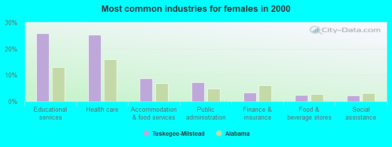
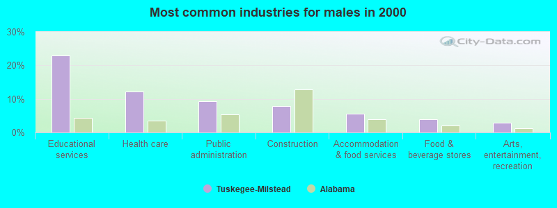
- Educational services (25.9%)
- Health care (25.4%)
- Accommodation & food services (8.8%)
- Public administration (7.3%)
- Finance & insurance (3.4%)
- Food & beverage stores (2.4%)
- Social assistance (2.3%)

- Nursing, psychiatric, and home health aides (5.4%)
- Other management occupations, except farmers and farm managers (4.9%)
- Other office and administrative support workers, including supervisors (4.7%)
- Building and grounds cleaning and maintenance occupations (4.3%)
- Preschool, kindergarten, elementary, and middle school teachers (4.1%)
- Other production occupations, including supervisors (3.5%)
- Cooks and food preparation workers (3.4%)
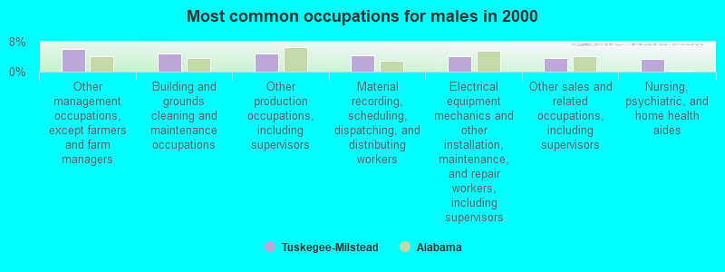
- Other management occupations, except farmers and farm managers (6.1%)
- Building and grounds cleaning and maintenance occupations (4.9%)
- Other production occupations, including supervisors (4.7%)
- Material recording, scheduling, dispatching, and distributing workers (4.5%)
- Electrical equipment mechanics and other installation, maintenance, and repair workers, including supervisors (4.1%)
- Other sales and related occupations, including supervisors (3.6%)
- Nursing, psychiatric, and home health aides (3.5%)

- Nursing, psychiatric, and home health aides (7.0%)
- Other office and administrative support workers, including supervisors (6.2%)
- Cashiers (5.7%)
- Secretaries and administrative assistants (5.5%)
- Preschool, kindergarten, elementary, and middle school teachers (5.2%)
- Cooks and food preparation workers (4.1%)
- Health technologists and technicians (4.0%)
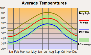
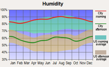
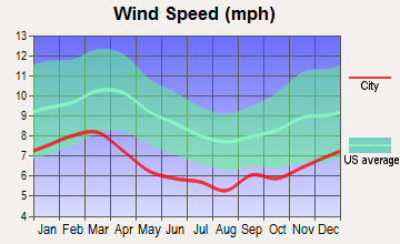
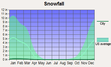
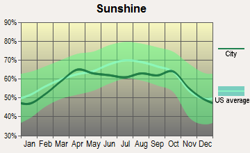
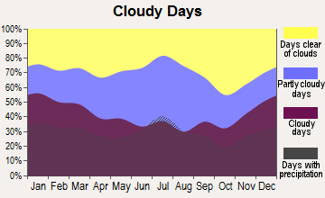
Average climate in Tuskegee-Milstead, Alabama
Based on data reported by over 4,000 weather stations
Tornado activity:
Tuskegee-Milstead-area historical tornado activity is slightly below Alabama state average. It is 42% greater than the overall U.S. average.
On 4/18/1969, a category F4 (max. wind speeds 207-260 mph) tornado 17.0 miles away from the Tuskegee-Milstead place center killed 2 people and injured 14 people and caused between $50,000 and $500,000 in damages.
On 4/18/1953, a category F3 (max. wind speeds 158-206 mph) tornado 14.6 miles away from the place center killed 8 people and injured 495 people and caused between $5,000,000 and $50,000,000 in damages.
Earthquake activity:
Tuskegee-Milstead-area historical earthquake activity is significantly above Alabama state average. It is 52% greater than the overall U.S. average.On 10/24/1997 at 08:35:17, a magnitude 4.9 (4.8 MB, 4.2 MS, 4.9 LG, Depth: 6.2 mi, Class: Light, Intensity: IV - V) earthquake occurred 128.2 miles away from the city center
On 1/18/1999 at 07:00:53, a magnitude 4.8 (4.8 MB, 4.0 LG, Depth: 0.6 mi) earthquake occurred 111.5 miles away from the city center
On 4/29/2003 at 08:59:39, a magnitude 4.9 (4.4 MB, 4.6 MW, 4.9 LG) earthquake occurred 143.0 miles away from the city center
On 4/29/2003 at 08:59:39, a magnitude 4.6 (4.6 MW, Depth: 12.3 mi) earthquake occurred 142.9 miles away from Tuskegee-Milstead center
On 8/2/1974 at 08:52:09, a magnitude 4.9 (4.3 MB, 4.9 LG) earthquake occurred 212.4 miles away from Tuskegee-Milstead center
On 6/24/1975 at 11:11:36, a magnitude 4.5 (4.5 MB) earthquake occurred 151.6 miles away from Tuskegee-Milstead center
Magnitude types: regional Lg-wave magnitude (LG), body-wave magnitude (MB), surface-wave magnitude (MS), moment magnitude (MW)
Natural disasters:
The number of natural disasters in Macon County (18) is near the US average (15).Major Disasters (Presidential) Declared: 10
Emergencies Declared: 6
Causes of natural disasters: Storms: 8, Tornadoes: 8, Floods: 7, Hurricanes: 5, Winds: 2, Drought: 1, Snowfall: 1, Winter Storm: 1, Other: 1 (Note: some incidents may be assigned to more than one category).
Hospitals and medical centers near Tuskegee-Milstead:
- MAGNOLIA HAVEN HEALTH AND REHABILITATION CENTER (Nursing Home, about 3 miles away; TUSKEGEE, AL)
- FMC TUSKEGEE (Dialysis Facility, about 3 miles away; TUSKEGEE, AL)
- COMMUNITY HOSPITAL INC Acute Care Hospitals (about 14 miles away; TALLASSEE, AL)
- TALLASSEE HEALTH AND REHABILITATION, LLC (Nursing Home, about 16 miles away; TALLASSEE, AL)
Colleges/universities with over 2000 students nearest to Tuskegee-Milstead:
- Tuskegee University (about 1 miles; Tuskegee, AL; Full-time enrollment: 2,810)
- Auburn University (about 19 miles; Auburn University, AL; FT enrollment: 22,741)
- Auburn University at Montgomery (about 27 miles; Montgomery, AL; FT enrollment: 4,092)
- Faulkner University (about 29 miles; Montgomery, AL; FT enrollment: 2,887)
- Alabama State University (about 34 miles; Montgomery, AL; FT enrollment: 5,457)
- Columbus Technical College (about 44 miles; Columbus, GA; FT enrollment: 3,241)
- Troy University (about 46 miles; Troy, AL; FT enrollment: 16,148)
Points of interest:
Notable locations in Tuskegee-Milstead: Tuskegee Industrial Park (A), Camp Atkins (B), Auburn University Experiment Station (C), Chehaw Volunteer Fire Department (D), Franklin Volunteer Fire Department (E), Carver Museum (F), Frissell Library (G), Tuskegee Fire Department (H), Macon County Courthouse (I). Display/hide their locations on the map
Churches in Tuskegee-Milstead include: Mount Andrew Church (A), Ramsey Church (B), Neils Chapel (C), New Hope Church (D), Saint John Church (E), Simmons Temple (F), Sweet Canaan Church (G), Tabernacle Church (H), Washington African Methodist Episcopal Chapel (I). Display/hide their locations on the map
Cemeteries: Bradford Chapel Cemetery (1), Bethel Cemetery (2), Walker Chapel Cemetery (3), Shady Grove Cemetery (4), Ramsey Cemetery (5), Neils Chapel Cemetery (6), Elam Cemetery (7). Display/hide their locations on the map
Reservoirs: Lake Carrona Number Two (A), Lake Carrona Number One (B), Fin and Feather Lake (C), City Lake (D). Display/hide their locations on the map
Creeks: Persimmon Creek (A), Red Creek (B). Display/hide their locations on the map
Parks in Tuskegee-Milstead include: Main Street Historic District (1), North Main Street Historic District (2), Tuskegee Institute National Historic Site (3), Cleveland Leigh Abbott Memorial Alumni Stadium (4), Abbott Park (5), Vetegee Stadium (6), Green Fork Park (7). Display/hide their locations on the map
| This place: | 2.4 people |
| Alabama: | 2.5 people |
| This place: | 38.5% |
| Whole state: | 70.4% |
| This place: | 4.1% |
| Whole state: | 3.4% |
Likely homosexual households (counted as self-reported same-sex unmarried-partner households)
- Lesbian couples: 0.2% of all households
- Gay men: 0.1% of all households
| This place: | 34.5% |
| Whole state: | 16.1% |
| This place: | 16.5% |
| Whole state: | 7.3% |
People in group quarters in Tuskegee-Milstead in 2000:
- 1,796 people in college dormitories (includes college quarters off campus)
- 387 people in nursing homes
- 47 people in short-term care, detention or diagnostic centers for delinquent children
- 17 people in other nonhousehold living situations
For population 15 years and over in Tuskegee-Milstead:
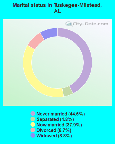
- Never married: 44.6%
- Now married: 37.9%
- Separated: 4.8%
- Widowed: 8.8%
- Divorced: 8.7%
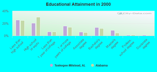
For population 25 years and over in Tuskegee-Milstead:
- High school or higher: 74.5%
- Bachelor's degree or higher: 25.3%
- Graduate or professional degree: 11.5%
- Unemployed: 15.2%
- Mean travel time to work (commute): 21.9 minutes
| Here: | 14.4 |
| Alabama average: | 13.2 |
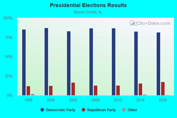
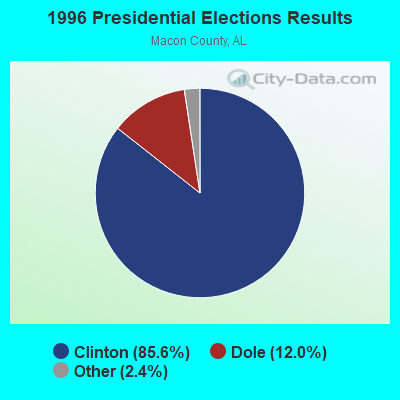
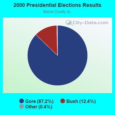

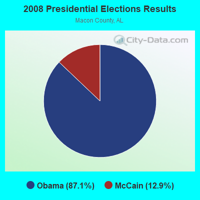
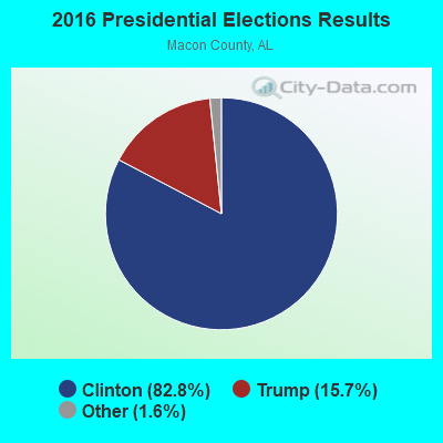
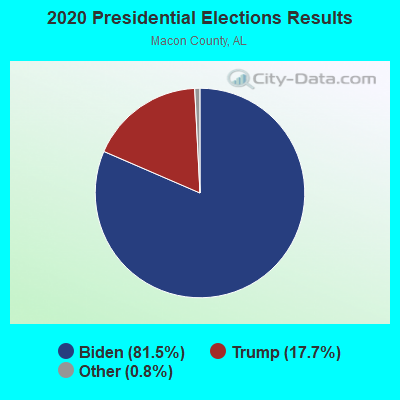
Graphs represent county-level data. Detailed 2008 Election Results
Religion statistics for Tuskegee-Milstead, AL (based on Macon County data)
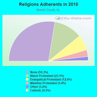
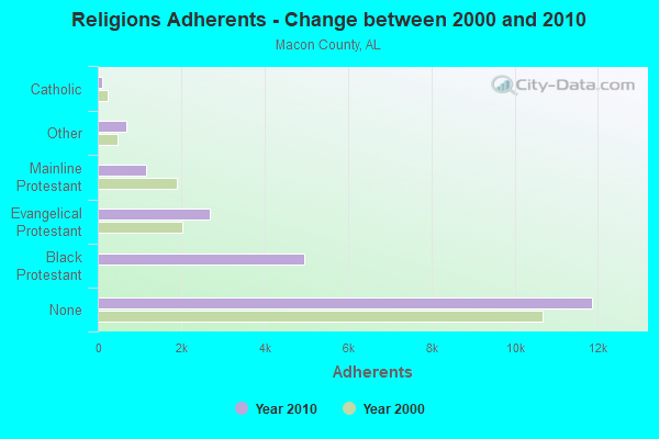
| Religion | Adherents | Congregations |
|---|---|---|
| Black Protestant | 4,945 | 28 |
| Evangelical Protestant | 2,695 | 18 |
| Mainline Protestant | 1,164 | 16 |
| Other | 679 | 4 |
| Catholic | 100 | 1 |
| None | 11,869 | - |
Food Environment Statistics:
| Macon County: | 2.24 / 10,000 pop. |
| Alabama: | 1.89 / 10,000 pop. |
| This county: | 0.45 / 10,000 pop. |
| Alabama: | 0.65 / 10,000 pop. |
| Macon County: | 7.17 / 10,000 pop. |
| Alabama: | 6.32 / 10,000 pop. |
| Macon County: | 2.24 / 10,000 pop. |
| Alabama: | 5.75 / 10,000 pop. |
| This county: | 15.2% |
| State: | 11.8% |
| Macon County: | 40.2% |
| State: | 31.7% |
| Macon County: | 17.3% |
| Alabama: | 13.5% |
Strongest AM radio stations in Tuskegee-Milstead:
- WBIL (580 AM; 0 kW; TUSKEGEE, AL; Owner: ALL CHANNEL TV SERVICES, INC.)
- WMSP (740 AM; 10 kW; MONTGOMERY, AL; Owner: CUMULUS LICENSING CORP.)
- WACV (1170 AM; 10 kW; MONTGOMERY, AL; Owner: MONTGOMERY BROADCAST PROPERTIES, LTD)
- WTLS (1300 AM; 1 kW; TALLASSEE, AL; Owner: MICHAEL BUTLER BROADCASTING. LLC)
- WJOX (690 AM; 50 kW; BIRMINGHAM, AL; Owner: CITADEL BROADCASTING COMPANY)
- WNSI (810 AM; 50 kW; JACKSONVILLE, AL; Owner: UNITED BROADCASTING NETWORK, INC.)
- WTLM (1520 AM; daytime; 5 kW; OPELIKA, AL; Owner: QANTUM OF AUBURN LICENSE COMPANY, LLC)
- WACQ (1130 AM; daytime; 1 kW; CARRVILLE, AL; Owner: PROGRESSIVE UNITED COMMUNICATIONS, INC.)
- WDAK (540 AM; 5 kW; COLUMBUS, GA; Owner: CLEAR CHANNEL BROADCASTING LICENSES, INC.)
- WDJC (850 AM; 50 kW; BIRMINGHAM, AL; Owner: KIMTRON, INC.)
- WGST (640 AM; 50 kW; ATLANTA, GA; Owner: CITICASTERS LICENSES, L.P.)
- WKNG (1060 AM; daytime; 50 kW; TALLAPOOSA, GA; Owner: WKNG, INC.)
- WAPZ (1250 AM; 5 kW; WETUMPKA, AL; Owner: J & W PROMOTIONS, INC.)
Strongest FM radio stations in Tuskegee-Milstead:
- WTGZ (95.9 FM; TUSKEGEE, AL; Owner: NEW WORLD COMMUNICATIONS, INC.)
- WQNR (99.9 FM; TALLASSEE, AL; Owner: TIGER COMMUNICATIONS, INC.)
- WLWI-FM (92.3 FM; MONTGOMERY, AL; Owner: CUMULUS LICENSING CORP.)
- WBAM-FM (98.9 FM; MONTGOMERY, AL; Owner: DEEP SOUTH BROADCASTING COMPANY)
- WHHY-FM (101.9 FM; MONTGOMERY, AL; Owner: CUMULUS LICENSING CORP.)
- WQLD (104.3 FM; LUVERNE, AL; Owner: CAPSTAR TX LIMITED PARTNERSHIP)
- WZHT (105.7 FM; TROY, AL; Owner: CAPSTAR TX LIMITED PARTNERSHIP)
- WSTH-FM (106.1 FM; ALEXANDER CITY, AL; Owner: CLEAR CHANNEL BROADCASTING LICENSES, INC.)
- WMXS (103.3 FM; MONTGOMERY, AL; Owner: CUMULUS LICENSING CORP.)
- WMXA (96.7 FM; OPELIKA, AL; Owner: QANTUM OF AUBURN LICENSE COMPANY, LLC)
- WKKR (97.7 FM; AUBURN, AL; Owner: QANTUM OF AUBURN LICENSE COMPANY, LLC)
- WTSU (89.9 FM; MONTGOMERY-TROY, AL; Owner: TROY STATE UNIVERSITY)
- WCGQ (107.3 FM; COLUMBUS, GA; Owner: ABG GEORGIA, LLC)
- W212AP (90.3 FM; NOTASULGA, ETC., AL; Owner: FAMILY STATIONS, INC.)
- WMCZ (97.1 FM; MILLBROOK, AL; Owner: CAPSTAR TX LIMITED PARTNERSHIP)
- WQKS-FM (96.1 FM; MONTGOMERY, AL; Owner: MONTGOMERY BROADCAST PROPERTIES, LTD)
- WLBF (89.1 FM; MONTGOMERY, AL; Owner: FAITH BROADCASTING, INC)
- WVAS (90.7 FM; MONTGOMERY, AL; Owner: ALABAMA STATE UNIVERSITY (ASU))
- WZLM (97.3 FM; DADEVILLE, AL; Owner: GREAT SOUTH RFDC, LLC)
- WEGL (91.1 FM; AUBURN, AL; Owner: BOARD OF TRUSTEES AUBURN UNIVERSITY)
TV broadcast stations around Tuskegee-Milstead:
- WNCF (Channel 32; MONTGOMERY, AL; Owner: CHANNEL 32 MONTGOMERY LLC)
- WSWS-TV (Channel 66; OPELIKA, AL; Owner: PAPPAS TELECASTING OF OPELIKA)
- WRJM-TV (Channel 67; TROY, AL; Owner: JOSIE PARK BROADCASTING, INC.)
- WSFA (Channel 12; MONTGOMERY, AL; Owner: LIBCO, INC.)
- WMCF-TV (Channel 45; MONTGOMERY, AL; Owner: TRINITY BROADCASTING NETWORK)
- WCOV-TV (Channel 20; MONTGOMERY, AL; Owner: WOODS COMMUNICATIONS CORPORATION)
- WTVM (Channel 9; COLUMBUS, GA; Owner: RAYCOM AMERICA, INC.)
- W18CD (Channel 18; OPELIKA, AL; Owner: TRINITY BROADCASTING NETWORK)
- W61DH (Channel 61; MONTGOMERY, AL; Owner: FRAZER MEMORIAL UNITED METHODIST CHURCH)
- WETU-LP (Channel 39; WETUMPKA, AL; Owner: CABLE VIDEO PRODUCTIONS, INC.)
- National Bridge Inventory (NBI) Statistics
- 27Number of bridges
- 289ft / 87.7mTotal length
- $23,958,000Total costs
- 10,820Total average daily traffic
- 1,906Total average daily truck traffic
- 12,840Total future (year 2021) average daily traffic
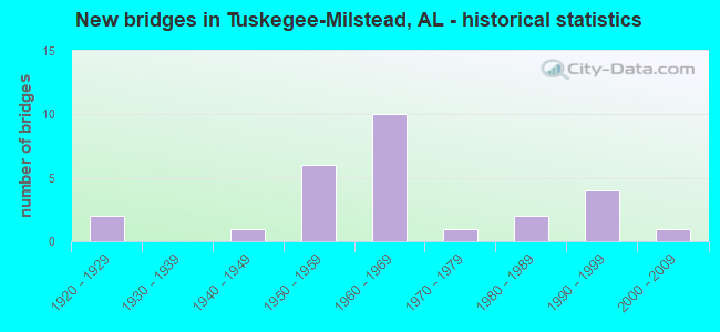
- New bridges - historical statistics
- 21920-1929
- 11940-1949
- 61950-1959
- 101960-1969
- 11970-1979
- 21980-1989
- 41990-1999
- 12000-2009
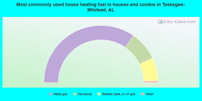
- 69.2%Utility gas
- 16.6%Electricity
- 13.2%Bottled, tank, or LP gas
- 0.8%No fuel used
- 0.2%Wood
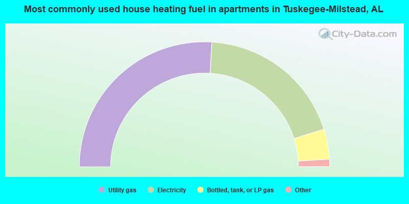
- 51.9%Utility gas
- 38.4%Electricity
- 7.8%Bottled, tank, or LP gas
- 0.9%Other fuel
- 0.5%Fuel oil, kerosene, etc.
- 0.5%Wood
Tuskegee-Milstead compared to Alabama state average:
- Median household income below state average.
- Median house value below state average.
- Black race population percentage significantly above state average.
- Hispanic race population percentage significantly below state average.
- Median age significantly below state average.
- Foreign-born population percentage significantly below state average.
- Renting percentage significantly below state average.
- Length of stay since moving in significantly above state average.
- Number of rooms per house significantly below state average.
- House age significantly below state average.
- Institutionalized population percentage significantly above state average.
- Number of college students above state average.
Tuskegee-Milstead on our top lists:
- #4 on the list of "Top 101 cities with largest percentage of males in occupations: nursing, psychiatric, and home health aides (population 5,000+)"
- #9 on the list of "Top 101 cities with largest percentage of males in occupations: other teachers and instructors, education, training, and library occupations (population 5,000+)"
- #9 on the list of "Top 101 cities with largest percentage of males in industries: health care (population 5,000+)"
- #21 on the list of "Top 101 cities with largest percentage of females in industries: health care (population 5,000+)"
- #29 on the list of "Top 101 cities with largest percentage of males in occupations: supervisors and other personal care and service workers except personal appearance, transportation, and child care workers (population 5,000+)"
- #32 on the list of "Top 101 cities with largest percentage of females in occupations: nursing, psychiatric, and home health aides (population 5,000+)"
- #32 on the list of "Top 101 cities with largest percentage of males in occupations: preschool, kindergarten, elementary and middle school teachers (population 5,000+)"
- #37 on the list of "Top 101 cities with largest percentage of males in occupations: librarians, curators, and archivists (population 5,000+)"
- #41 on the list of "Top 101 cities with the lowest percentage of family households, population 10,000+"
- #62 on the list of "Top 101 cities with largest percentage of males in industries: retail florists (population 5,000+)"
- #78 on the list of "Top 101 cities with the largest percentage of people in short-term care, detention or diagnostic centers for delinquent children (population 1,000+)"
- #93 on the list of "Top 101 cities with the largest household incomes disparities (population 5,000+)"
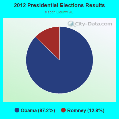
- #11 on the list of "Top 101 counties with highest percentage of residents voting for Obama (Democrat) in the 2012 Presidential Election"