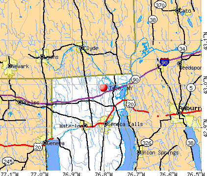
Tyre, New York
Submit your own pictures of this town and show them to the world
- OSM Map
- General Map
- Google Map
- MSN Map
Population change since 2000: +9.1%
 |
| Males: 495 | |
| Females: 486 |
| Median resident age: | 40.0 years |
| New York median age: | 40.7 years |
Zip codes: 13148.
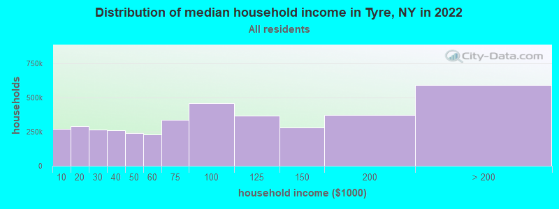
| Tyre: | $74,281 |
| NY: | $79,557 |
Estimated per capita income in 2022: $34,794 (it was $17,836 in 2000)
Tyre town income, earnings, and wages data
Estimated median house or condo value in 2022: $148,743 (it was $76,100 in 2000)
| Tyre: | $148,743 |
| NY: | $400,400 |
Detailed information about poverty and poor residents in Tyre, NY


- 95096.8%White alone
- 141.4%Hispanic
- 131.3%Two or more races
- 30.3%Asian alone
- 10.1%American Indian alone
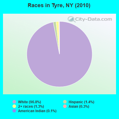
Races in Tyre detailed stats: ancestries, foreign born residents, place of birth
 Recent articles from our blog. Our writers, many of them Ph.D. graduates or candidates, create easy-to-read articles on a wide variety of topics.

 | British Invasion 2022: "Tyre Extinguishers" Activists Arrive in NYC, Slash The Tires of 40 SUV's on UES (6 replies) |
| A casino in Rochester? (105 replies) |
| Post here for Finger Lakes Region (Seneca Lake area) (13 replies) |
| Amazon coming to Rochester?-Of course (140 replies) |
| Tell me about New York's micropolitan areas (73 replies) |
| Syracuse Construction Update (4328 replies) |
Latest news from Tyre, NY collected exclusively by city-data.com from local newspapers, TV, and radio stations
Ancestries: English (25.0%), German (23.4%), Irish (15.4%), Italian (12.8%), Dutch (7.5%), United States (5.2%).
Current Local Time: EST time zone
Elevation: 400 feet
Land area: 30.1 square miles.
Population density: 33 people per square mile (very low).

19 residents are foreign born (1.4% Europe, 0.7% North America).
| This town: | 2.1% |
| New York: | 20.4% |
| Tyre town: | 2.2% ($1,696) |
| New York: | 1.9% ($2,847) |
Nearest city with pop. 50,000+: Clay, NY  (32.0 miles , pop. 58,805).
Nearest city with pop. 200,000+: Rochester, NY (43.6 miles , pop. 219,773).
Nearest city with pop. 1,000,000+: Bronx, NY (210.5 miles , pop. 1,332,650).
Nearest cities:
), ), ), ), ), )Latitude: 42.98 N, Longitude: 76.79 W
Area code commonly used in this area: 315

| Here: | 4.1% |
| New York: | 4.4% |
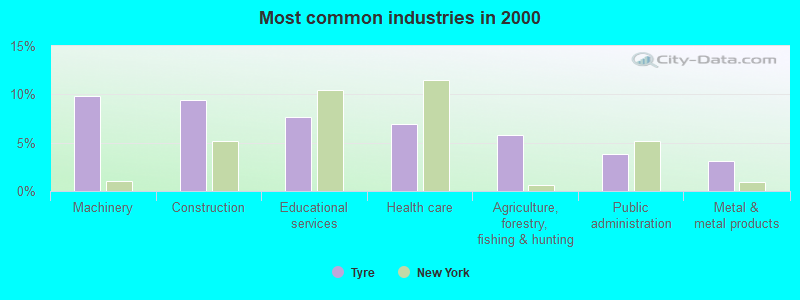
- Machinery (9.8%)
- Construction (9.4%)
- Educational services (7.6%)
- Health care (6.9%)
- Agriculture, forestry, fishing & hunting (5.8%)
- Public administration (3.8%)
- Metal & metal products (3.1%)
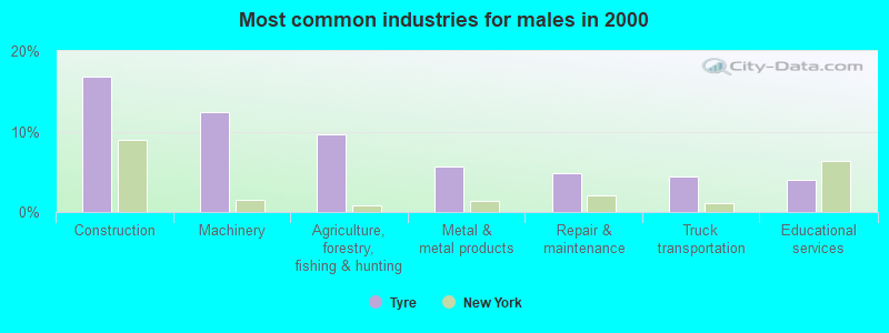
- Construction (16.8%)
- Machinery (12.4%)
- Agriculture, forestry, fishing & hunting (9.6%)
- Metal & metal products (5.6%)
- Repair & maintenance (4.8%)
- Truck transportation (4.4%)
- Educational services (4.0%)
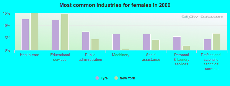
- Health care (12.7%)
- Educational services (12.2%)
- Public administration (7.6%)
- Machinery (6.6%)
- Social assistance (6.6%)
- Personal & laundry services (5.6%)
- Professional, scientific, technical services (4.6%)
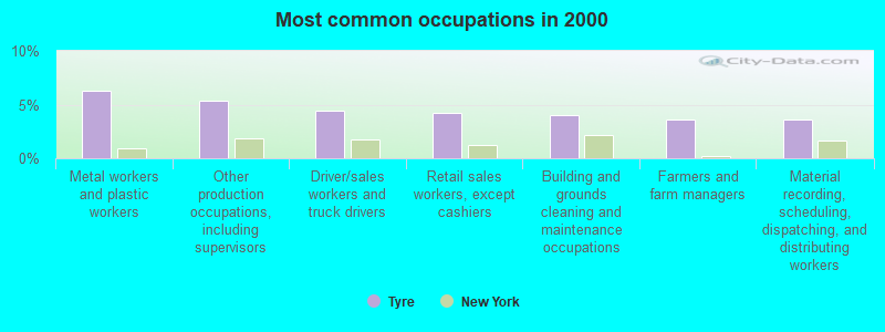
- Metal workers and plastic workers (6.3%)
- Other production occupations, including supervisors (5.4%)
- Driver/sales workers and truck drivers (4.5%)
- Retail sales workers, except cashiers (4.3%)
- Building and grounds cleaning and maintenance occupations (4.0%)
- Farmers and farm managers (3.6%)
- Material recording, scheduling, dispatching, and distributing workers (3.6%)
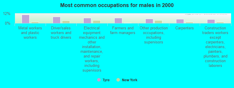
- Metal workers and plastic workers (10.4%)
- Driver/sales workers and truck drivers (8.0%)
- Electrical equipment mechanics and other installation, maintenance, and repair workers, including supervisors (6.4%)
- Farmers and farm managers (6.4%)
- Other production occupations, including supervisors (5.6%)
- Carpenters (5.2%)
- Construction traders workers except carpenters, electricians, painters, plumbers, and construction laborers (4.8%)
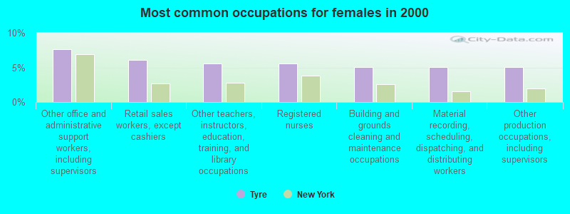
- Other office and administrative support workers, including supervisors (7.6%)
- Retail sales workers, except cashiers (6.1%)
- Other teachers, instructors, education, training, and library occupations (5.6%)
- Registered nurses (5.6%)
- Building and grounds cleaning and maintenance occupations (5.1%)
- Material recording, scheduling, dispatching, and distributing workers (5.1%)
- Other production occupations, including supervisors (5.1%)
Average climate in Tyre, New York
Based on data reported by over 4,000 weather stations


Tornado activity:
Tyre-area historical tornado activity is below New York state average. It is 78% smaller than the overall U.S. average.
On 5/2/1983, a category F3 (max. wind speeds 158-206 mph) tornado 15.3 miles away from the Tyre town center killed one person and caused between $500,000 and $5,000,000 in damages.
On 5/2/1983, a category F3 tornado 29.8 miles away from the town center caused between $50,000 and $500,000 in damages.
Earthquake activity:
Tyre-area historical earthquake activity is significantly above New York state average. It is 68% smaller than the overall U.S. average.On 10/7/1983 at 10:18:46, a magnitude 5.3 (5.1 MB, 5.3 LG, 5.1 ML, Class: Moderate, Intensity: VI - VII) earthquake occurred 139.7 miles away from the city center
On 4/20/2002 at 10:50:47, a magnitude 5.3 (5.3 ML, Depth: 3.0 mi) earthquake occurred 187.0 miles away from the city center
On 4/20/2002 at 10:50:47, a magnitude 5.2 (5.2 MB, 4.2 MS, 5.2 MW, 5.0 MW) earthquake occurred 185.2 miles away from the city center
On 9/25/1998 at 19:52:52, a magnitude 5.2 (4.8 MB, 4.3 MS, 5.2 LG, 4.5 MW, Depth: 3.1 mi) earthquake occurred 211.8 miles away from the city center
On 8/23/2011 at 17:51:04, a magnitude 5.8 (5.8 MW, Depth: 3.7 mi) earthquake occurred 356.2 miles away from Tyre center
On 1/31/1986 at 16:46:43, a magnitude 5.0 (5.0 MB) earthquake occurred 243.4 miles away from the city center
Magnitude types: regional Lg-wave magnitude (LG), body-wave magnitude (MB), local magnitude (ML), surface-wave magnitude (MS), moment magnitude (MW)
Natural disasters:
The number of natural disasters in Seneca County (9) is smaller than the US average (15).Major Disasters (Presidential) Declared: 3
Emergencies Declared: 5
Causes of natural disasters: Hurricanes: 2, Blizzard: 1, Flood: 1, Ice Storm: 1, Power Outage: 1, Storm: 1, Tropical Storm: 1, Other: 2 (Note: some incidents may be assigned to more than one category).

Hospitals and medical centers near Tyre:
- SENECA FALLS HOSP (Hospital, about 6 miles away; SENECA FALLS, NY)
- SENECA NURSING AND REHABILITATION CENTER (Nursing Home, about 7 miles away; WATERLOO, NY)
- HUNTINGTON LIVING CENTER (Nursing Home, about 7 miles away; WATERLOO, NY)
- MERCY HEALTH AND REHAB CENTER N H INC (Nursing Home, about 12 miles away; AUBURN, NY)
- FINGER LAKES CENTER FOR LIVING (Nursing Home, about 12 miles away; AUBURN, NY)
- CAYUGA COUNTY CHHA (Home Health Center, about 12 miles away; AUBURN, NY)
- AUBURN NURSING HOME (Nursing Home, about 12 miles away; AUBURN, NY)
Colleges/universities with over 2000 students nearest to Tyre:
- Cayuga County Community College (about 13 miles; Auburn, NY; Full-time enrollment: 3,141)
- Hobart William Smith Colleges (about 14 miles; Geneva, NY; FT enrollment: 2,476)
- Finger Lakes Community College (about 25 miles; Canandaigua, NY; FT enrollment: 4,732)
- Onondaga Community College (about 30 miles; Syracuse, NY; FT enrollment: 8,920)
- SUNY College of Environmental Science and Forestry (about 33 miles; Syracuse, NY; FT enrollment: 2,044)
- Syracuse University (about 34 miles; Syracuse, NY; FT enrollment: 20,717)
- SUNY College at Oswego (about 35 miles; Oswego, NY; FT enrollment: 7,550)
Points of interest:
Notable locations in Tyre: Halsey Corners (A), Waterloo Toll Plaza (B), Magee Volunteer Fire Department (C). Display/hide their locations on the map
Churches in Tyre include: Tyre Church (A), Tyre United Methodist Church (B). Display/hide their locations on the map
Cemeteries: Tyre City Cemetery (1), Dutch Cemetery (2), Crusoe Cemetery (3), Traver Cemetery (4). Display/hide their locations on the map
Lakes and swamps: Black Lake (A), Montezuma Marsh (B). Display/hide their locations on the map
Streams, rivers, and creeks: White Brook (A), Black Brook (B), Clyde River (C). Display/hide their locations on the map
Park in Tyre: Montezuma National Wildlife Refuge (1). Display/hide its location on the map
Birthplace of: George Lucas Hartsuff - Army general.
| This town: | 2.8 people |
| New York: | 2.6 people |
| This town: | 73.9% |
| Whole state: | 63.5% |
| This town: | 11.5% |
| Whole state: | 6.8% |
Likely homosexual households (counted as self-reported same-sex unmarried-partner households)
- Lesbian couples: 0.6% of all households
- Gay men: 0.6% of all households
| This town: | 10.2% |
| Whole state: | 14.6% |
| This town: | 3.7% |
| Whole state: | 7.4% |
For population 15 years and over in Tyre:
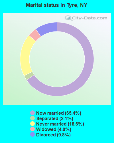
- Never married: 18.6%
- Now married: 65.4%
- Separated: 2.1%
- Widowed: 4.0%
- Divorced: 9.8%
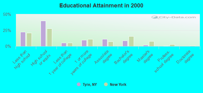
For population 25 years and over in Tyre:
- High school or higher: 77.6%
- Bachelor's degree or higher: 11.4%
- Graduate or professional degree: 2.5%
- Unemployed: 5.5%
- Mean travel time to work (commute): 24.1 minutes
| Here: | 10.3 |
| New York average: | 14.2 |
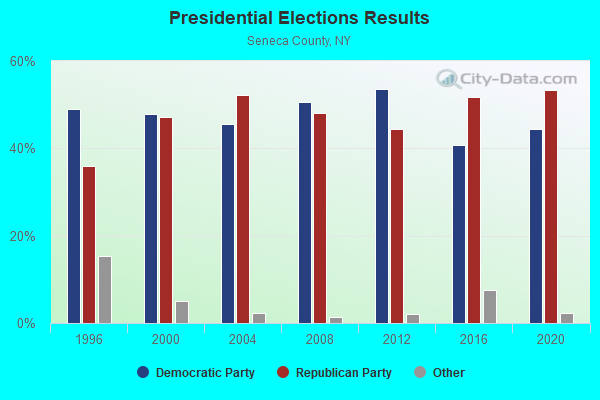
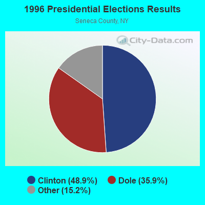
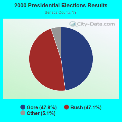
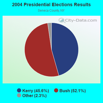
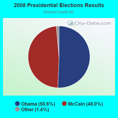
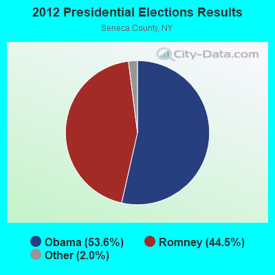
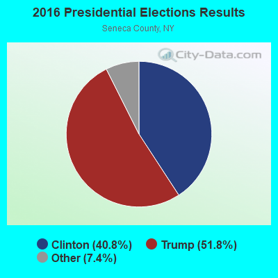
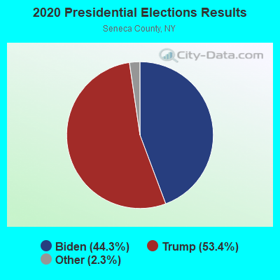
Graphs represent county-level data. Detailed 2008 Election Results
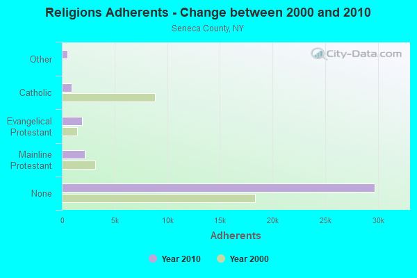
Religion statistics for Tyre, NY (based on Seneca County data)
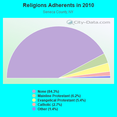
| Religion | Adherents | Congregations |
|---|---|---|
| Mainline Protestant | 2,178 | 18 |
| Evangelical Protestant | 1,893 | 19 |
| Catholic | 943 | 2 |
| Other | 506 | 3 |
| Orthodox | - | - |
| None | 29,731 | - |
Food Environment Statistics:
| This county: | 2.92 / 10,000 pop. |
| New York: | 4.13 / 10,000 pop. |
| Seneca County: | 0.88 / 10,000 pop. |
| State: | 0.92 / 10,000 pop. |
| Here: | 3.21 / 10,000 pop. |
| State: | 1.68 / 10,000 pop. |
| Here: | 7.89 / 10,000 pop. |
| New York: | 8.82 / 10,000 pop. |
| Here: | 8.2% |
| New York: | 8.2% |
| Seneca County: | 30.3% |
| New York: | 23.8% |
| Seneca County: | 16.9% |
| State: | 15.6% |
Strongest AM radio stations in Tyre:
- WSFW (1110 AM; daytime; 1 kW; SENECA FALLS, NY; Owner: AUBURN BROADCASTING, INC.)
- WHAM (1180 AM; 50 kW; ROCHESTER, NY; Owner: CITICASTERS LICENSES, L.P.)
- WACK (1420 AM; 5 kW; NEWARK, NY; Owner: PEMBROOK PINES, INC.)
- WSYR (570 AM; 5 kW; SYRACUSE, NY; Owner: CLEAR CHANNEL BROADCASTING LICENSES, INC.)
- WHEN (620 AM; 5 kW; SYRACUSE, NY; Owner: CLEAR CHANNEL BROADCASTING LICENSES, INC.)
- WWLF (1340 AM; 1 kW; AUBURN, NY; Owner: WOLF RADIO, INC)
- WAUB (1590 AM; 1 kW; AUBURN, NY; Owner: AUBURN BROADCASTING, INC.)
- WPIE (1160 AM; 5 kW; TRUMANSBURG, NY; Owner: PEMBROOK PINES ITHACA LTD. N.A.)
- WGVA (1240 AM; 1 kW; GENEVA, NY; Owner: GENEVA BROADCASTING INC)
- WDCW (1390 AM; 5 kW; SYRACUSE, NY; Owner: KIMTRON, INC.)
- WFBL (1050 AM; 2 kW; BALDWINSVILLE, NY; Owner: BUCKLEY BROADCASTING CORPORATION)
- WHCU (870 AM; 5 kW; ITHACA, NY; Owner: EAGLE BROADCASTING COMPANY, INC.)
- WFLR (1570 AM; 5 kW; DUNDEE, NY; Owner: LAKES COUNTY COMMUNICATION CORP.)
Strongest FM radio stations in Tyre:
- WLLW (99.3 FM; SENECA FALLS, NY; Owner: AUBURN BROADCASTING, INC.)
- WCOV-FM (93.7 FM; CLYDE, NY; Owner: FAMILY LIFE MINISTRIES, INC.)
- WPHR (106.9 FM; AUBURN, NY; Owner: CLEAR CHANNEL BROADCASTING LICENSES, INC.)
- WNYR-FM (98.5 FM; WATERLOO, NY; Owner: LAKE COUNTRY BROADCASTING, INC.)
- WFLK (101.7 FM; GENEVA, NY; Owner: MB COMMUNICATIONS, INC.)
- WISY (102.3 FM; CANANDAIGUA, NY; Owner: CITICASTERS LICENSES, L.P.)
- WCIY (88.9 FM; CANANDAIGUA, NY; Owner: FAMILY LIFE MINISTRIES, INC.)
- WMHR (102.9 FM; SYRACUSE, NY; Owner: MARS HILL BROADCASTING CO., INC.)
- WFXF (107.3 FM; SOUTH BRISTOL TOWNSH, NY; Owner: CITICASTERS LICENSES, L.P.)
- WNVE (95.1 FM; HONEOYE FALLS, NY; Owner: CITICASTERS LICENSES, L.P.)
- WFRW (88.1 FM; WEBSTER, NY; Owner: FAMILY STATIONS, INC.)
- WBBS (104.7 FM; FULTON, NY; Owner: CITICASTERS LICENSES, L.P.)
- WQNY (103.7 FM; ITHACA, NY; Owner: EAGLE II BROADCASTING CORPORATION)
- WYXL (97.3 FM; ITHACA, NY; Owner: EAGLE BROADCASTING COMPANY)
- WEOS (89.7 FM; GENEVA, NY; Owner: THE COLLEGES OF THE SENECA)
- WYYY (94.5 FM; SYRACUSE, NY; Owner: CLEAR CHANNEL BROADCASTING LICENSES, INC.)
- WFLR-FM (95.9 FM; DUNDEE, NY; Owner: LAKES COUNTRY COMMUNICATIONS CORP.)
- W251AK (98.1 FM; NEDROW, NY; Owner: PATHWAY COMMUNITY RADIO, INC.)
- W251AJ (98.1 FM; MELROSE PARK, NY; Owner: FMX BROADCASTING)
- WDWN (89.1 FM; AUBURN, NY; Owner: CAYUGA COUNTY COMM. COLLEGE)
TV broadcast stations around Tyre:
- WCNY-TV (Channel 24; SYRACUSE, NY; Owner: PUBLIC BROADCASTING COUNCIL OF CENTRAL NEW YORK)
- WSTM-TV (Channel 3; SYRACUSE, NY; Owner: WSTM LICENSE SUBSIDIARY, INC.)
- WSYT (Channel 68; SYRACUSE, NY; Owner: WSYT LICENSEE L.P.)
- WIXT-TV (Channel 9; SYRACUSE, NY; Owner: CENTRAL NY NEWS, INC.)
- WNYS-TV (Channel 43; SYRACUSE, NY; Owner: RKM MEDIA, INC.)
- W48AO (Channel 48; AUBURN, NY; Owner: SONNY PERSAD)
- W69AN (Channel 69; UNION SPRINGS, ETC., NY; Owner: SONNY PERSAD)
- WSPX-TV (Channel 56; SYRACUSE, NY; Owner: PAXSON SYRACUSE LICENSE, INC.)
- W54AK (Channel 54; AUBURN, NY; Owner: SONNY PERSAD)
- National Bridge Inventory (NBI) Statistics
- 24Number of bridges
- 538ft / 164mTotal length
- $98,457,000Total costs
- 211,715Total average daily traffic
- 28,196Total average daily truck traffic
- New bridges - historical statistics
- 11910-1919
- 11930-1939
- 11940-1949
- 111950-1959
- 21960-1969
- 51990-1999
- 32000-2009
FCC Registered Broadcast Land Mobile Towers:
2- Int Of Cr 373 & Olmstead Rd (Lat: 43.021444 Lon: -76.774944), Call Sign: KNGG269,
Assigned Frequencies: 152.885 MHz, Grant Date: 12/15/2012, Expiration Date: 03/14/2023, Cancellation Date: 05/20/2023, Registrant: Furman Communications, Inc., Savannah, NY 13146, Phone: (315) 365-3700
- East Rd (Lat: 43.019500 Lon: -76.760500), Call Sign: WNBH205, Licensee ID: L00056988,
Assigned Frequencies: 151.565 MHz, Grant Date: 12/07/1999, Expiration Date: 02/15/2005, Cancellation Date: 04/23/2005, Registrant: Savannah Agri Air Inc, Savannah, NY 13146-0130, Phone: (315) 365-3302
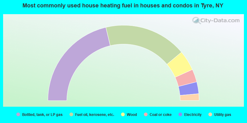
- 42.5%Bottled, tank, or LP gas
- 35.3%Fuel oil, kerosene, etc.
- 8.7%Wood
- 5.5%Coal or coke
- 5.1%Electricity
- 2.9%Utility gas
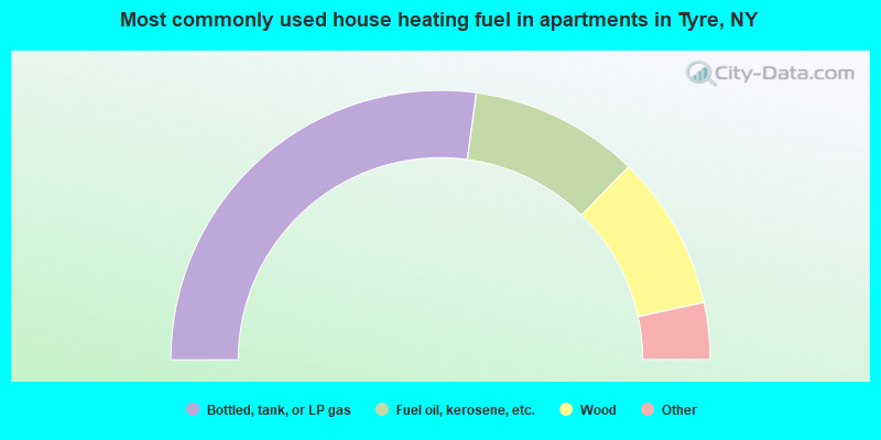
- 54.2%Bottled, tank, or LP gas
- 20.3%Fuel oil, kerosene, etc.
- 18.6%Wood
- 3.4%Utility gas
- 3.4%Electricity
Tyre compared to New York state average:
- Median house value significantly below state average.
- Unemployed percentage below state average.
- Black race population percentage significantly below state average.
- Hispanic race population percentage significantly below state average.
- Foreign-born population percentage significantly below state average.
- Renting percentage significantly below state average.
- Length of stay since moving in significantly above state average.
- Number of rooms per house significantly below state average.
- House age significantly below state average.
- Number of college students below state average.
- Percentage of population with a bachelor's degree or higher significantly below state average.