Verona, Maine
Submit your own pictures of this town and show them to the world
- OSM Map
- General Map
- Google Map
- MSN Map
| Males: 266 | |
| Females: 282 |
| Median resident age: | 43.6 years |
| Maine median age: | 38.6 years |
Zip codes: 04416.
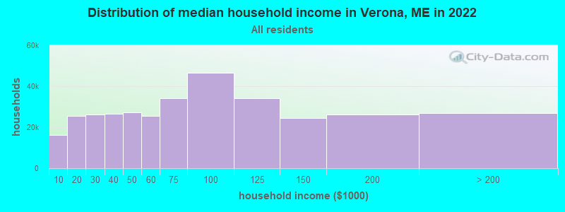
| Verona: | $76,344 |
| ME: | $69,543 |
Estimated per capita income in 2022: $42,058 (it was $20,714 in 2000)
Verona town income, earnings, and wages data
Estimated median house or condo value in 2022: $239,705 (it was $83,700 in 2000)
| Verona: | $239,705 |
| ME: | $290,600 |
Mean prices in 2022: all housing units: $379,336; detached houses: $396,802; townhouses or other attached units: $600,716; in 2-unit structures: $274,479; in 3-to-4-unit structures: $212,346; in 5-or-more-unit structures: $146,369; mobile homes: $158,183; occupied boats, rvs, vans, etc.: $16,454
Detailed information about poverty and poor residents in Verona, ME


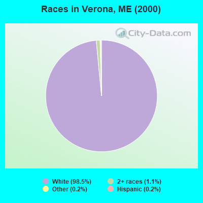
- 52598.5%White alone
- 61.1%Two or more races
- 10.2%Other race alone
- 10.2%Hispanic
Races in Verona detailed stats: ancestries, foreign born residents, place of birth
According to our research of Maine and other state lists, there was 1 registered sex offender living in Verona, Maine as of April 19, 2024.
The ratio of all residents to sex offenders in Verona is 548 to 1.
The ratio of registered sex offenders to all residents in this city is near the state average.
 Recent articles from our blog. Our writers, many of them Ph.D. graduates or candidates, create easy-to-read articles on a wide variety of topics.

 | Bucksport/Verona Island (3 replies) |
| Small houses Part 2 (86 replies) |
| Blue Hill - midcoast or downeast? (27 replies) |
| LePage: "Bring back the guillotine" (90 replies) |
| What do you like and don't like about living in Maine? (102 replies) |
| Lived in Maine a long time but have never ... (15 replies) |
Latest news from Verona, ME collected exclusively by city-data.com from local newspapers, TV, and radio stations
Ancestries: English (23.3%), United States (20.3%), Irish (10.3%), French (9.0%), German (6.0%), Scottish (5.8%).
Current Local Time: EST time zone
Incorporated on 02/18/1861
Elevation: 75 feet
Land area: 6.23 square miles.
Population density: 88 people per square mile (very low).
23 residents are foreign born (2.8% North America, 1.1% Europe).
| This town: | 4.3% |
| Maine: | 2.9% |
| Verona town: | 0.9% ($721) |
| Maine: | 1.5% ($1,417) |
Nearest city with pop. 50,000+: Portland, ME  (94.5 miles , pop. 64,249).
Nearest city with pop. 200,000+: Boston, MA (191.3 miles , pop. 589,141).
Nearest city with pop. 1,000,000+: Bronx, NY (362.6 miles , pop. 1,332,650).
Nearest cities:
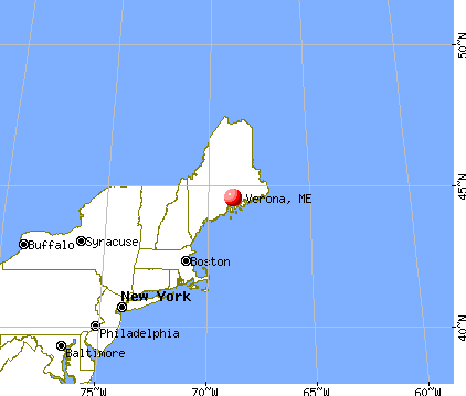
), ), ), Latitude: 44.53 N, Longitude: 68.80 W
Area code commonly used in this area: 207

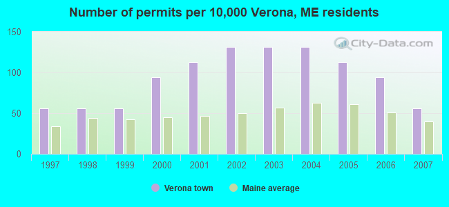
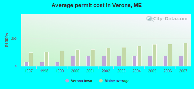
Single-family new house construction building permits:
- 2007: 3 buildings, average cost: $76,000
- 2006: 5 buildings, average cost: $76,000
- 2005: 6 buildings, average cost: $76,000
- 2004: 7 buildings, average cost: $76,000
- 2003: 7 buildings, average cost: $76,000
- 2002: 7 buildings, average cost: $76,000
- 2001: 6 buildings, average cost: $76,000
- 2000: 5 buildings, average cost: $76,000
- 1999: 3 buildings, average cost: $29,700
- 1998: 3 buildings, average cost: $29,700
- 1997: 3 buildings, average cost: $29,700
| Here: | 4.3% |
| Maine: | 3.4% |
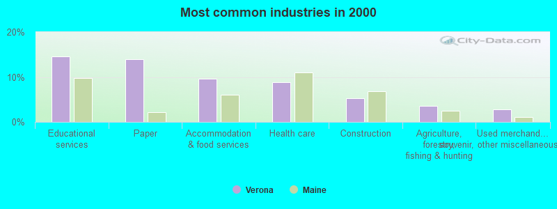
- Educational services (14.6%)
- Paper (13.9%)
- Accommodation & food services (9.6%)
- Health care (8.9%)
- Construction (5.3%)
- Agriculture, forestry, fishing & hunting (3.6%)
- Used merchandise, gift, novelty, souvenir, other miscellaneous stores (2.8%)
- Paper (22.0%)
- Educational services (11.3%)
- Construction (9.4%)
- Health care (5.7%)
- Agriculture, forestry, fishing & hunting (5.0%)
- Accommodation & food services (5.0%)
- Used merchandise, gift, novelty, souvenir, other miscellaneous stores (3.8%)

- Educational services (18.9%)
- Accommodation & food services (15.6%)
- Health care (13.1%)
- Social assistance (5.7%)
- Other transportation, support activities, couriers (4.1%)
- Finance & insurance (4.1%)
- Food (3.3%)
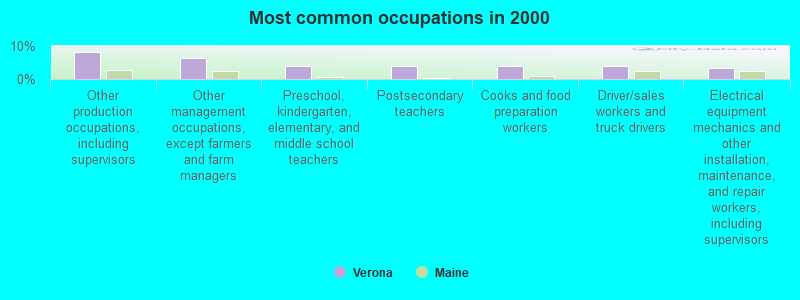
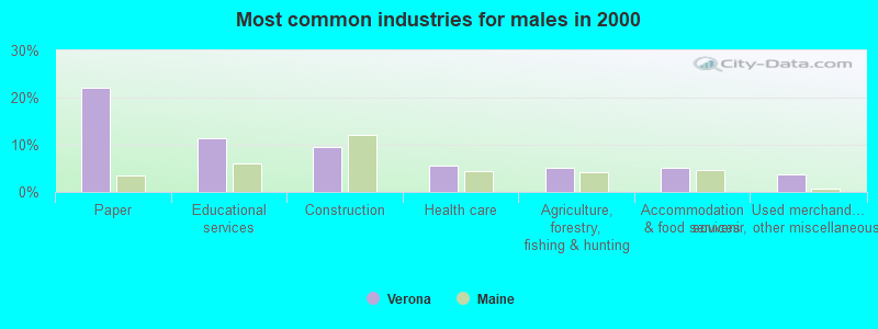
- Other production occupations, including supervisors (8.2%)
- Other management occupations, except farmers and farm managers (6.4%)
- Preschool, kindergarten, elementary, and middle school teachers (3.9%)
- Postsecondary teachers (3.9%)
- Cooks and food preparation workers (3.9%)
- Driver/sales workers and truck drivers (3.9%)
- Electrical equipment mechanics and other installation, maintenance, and repair workers, including supervisors (3.2%)
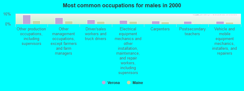
- Other production occupations, including supervisors (14.5%)
- Other management occupations, except farmers and farm managers (10.1%)
- Driver/sales workers and truck drivers (6.9%)
- Electrical equipment mechanics and other installation, maintenance, and repair workers, including supervisors (5.7%)
- Carpenters (5.0%)
- Postsecondary teachers (4.4%)
- Vehicle and mobile equipment mechanics, installers, and repairers (4.4%)

- Cooks and food preparation workers (6.6%)
- Preschool, kindergarten, elementary, and middle school teachers (5.7%)
- Registered nurses (5.7%)
- Other food preparation and serving workers, including supervisors (4.9%)
- Secretaries and administrative assistants (4.9%)
- Other teachers, instructors, education, training, and library occupations (4.1%)
- Counselors, social workers, and other community and social service specialists (4.1%)
Average climate in Verona, Maine
Based on data reported by over 4,000 weather stations


(lower is better)
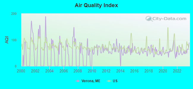
Air Quality Index (AQI) level in 2023 was 61.1. This is about average.
| City: | 61.1 |
| U.S.: | 72.6 |
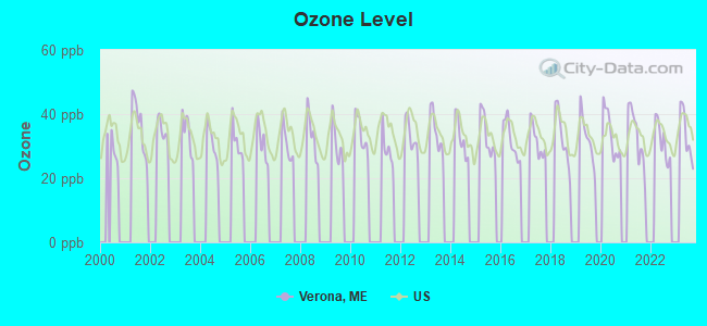
Ozone [ppb] level in 2023 was 33.6. This is about average. Closest monitor was 7.5 miles away from the city center.
| City: | 33.6 |
| U.S.: | 33.3 |
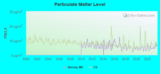
Particulate Matter (PM2.5) [µg/m3] level in 2023 was 5.62. This is significantly better than average. Closest monitor was 18.6 miles away from the city center.
| City: | 5.62 |
| U.S.: | 8.11 |
Earthquake activity:
Verona-area historical earthquake activity is significantly above Maine state average. It is 79% smaller than the overall U.S. average.On 10/16/2012 at 23:12:25, a magnitude 4.7 (4.7 ML, Depth: 10.0 mi, Class: Light, Intensity: IV - V) earthquake occurred 112.8 miles away from Verona center
On 4/20/2002 at 10:50:47, a magnitude 5.3 (5.3 ML, Depth: 3.0 mi, Class: Moderate, Intensity: VI - VII) earthquake occurred 241.7 miles away from the city center
On 4/20/2002 at 10:50:47, a magnitude 5.2 (5.2 MB, 4.2 MS, 5.2 MW, 5.0 MW) earthquake occurred 242.7 miles away from Verona center
On 1/19/1982 at 00:14:42, a magnitude 4.7 (4.5 MB, 4.7 MD, 4.5 LG) earthquake occurred 156.6 miles away from Verona center
On 10/7/1983 at 10:18:46, a magnitude 5.3 (5.1 MB, 5.3 LG, 5.1 ML) earthquake occurred 277.6 miles away from Verona center
On 2/26/1999 at 03:38:43, a magnitude 3.8 (3.8 LG, Depth: 2.0 mi, Class: Light, Intensity: II - III) earthquake occurred 35.9 miles away from Verona center
Magnitude types: regional Lg-wave magnitude (LG), body-wave magnitude (MB), duration magnitude (MD), local magnitude (ML), surface-wave magnitude (MS), moment magnitude (MW)
Natural disasters:
The number of natural disasters in Hancock County (18) is near the US average (15).Major Disasters (Presidential) Declared: 11
Emergencies Declared: 6
Causes of natural disasters: Floods: 9, Storms: 8, Snows: 5, Blizzard: 1, Heavy Rain: 1, Hurricane: 1, Ice Storm: 1, Landslide: 1, Snowfall: 1, Wind: 1, Winter Storm: 1, Other: 2 (Note: some incidents may be assigned to more than one category).
Hospitals and medical centers near Verona:
- HARBOR HILL CENTER (Nursing Home, about 13 miles away; BELFAST, ME)
- BRADBURY MANOR (Nursing Home, about 13 miles away; BELFAST, ME)
- THE COMMONS AT TALL PINES (Nursing Home, about 13 miles away; BELFAST, ME)
- DIALYSIS CLINIC INC. - BELFAST (Dialysis Facility, about 13 miles away; BELFAST, ME)
- WALDO COUNTY GENERAL HOSPITAL Critical Access Hospitals (about 14 miles away; BELFAST, ME)
Colleges/universities with over 2000 students nearest to Verona:
- Husson University (about 21 miles; Bangor, ME; Full-time enrollment: 2,421)
- University of Maine (about 26 miles; Orono, ME; FT enrollment: 8,931)
- University of Maine at Augusta (about 52 miles; Augusta, ME; FT enrollment: 3,204)
- University of Maine at Farmington (about 68 miles; Farmington, ME; FT enrollment: 2,036)
- Southern Maine Community College (about 94 miles; South Portland, ME; FT enrollment: 4,666)
- University of Southern Maine (about 95 miles; Portland, ME; FT enrollment: 6,647)
- Saint Joseph's College of Maine (about 97 miles; Standish, ME; FT enrollment: 2,010)
Points of interest:
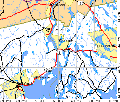
Notable location: The Flying Dutchman Campground (A). Display/hide its location on the map
Cemeteries: Village Cemetery (1), Whitman Cemetery (2). Display/hide their locations on the map
Streams, rivers, and creeks: Ulmer Brook (A). Display/hide its location on the map
| This town: | 2.4 people |
| Maine: | 2.4 people |
| This town: | 72.6% |
| Whole state: | 66.1% |
| This town: | 6.3% |
| Whole state: | 7.3% |
Likely homosexual households (counted as self-reported same-sex unmarried-partner households)
- Lesbian couples: 0.0% of all households
- Gay men: 0.4% of all households
| This town: | 6.5% |
| Whole state: | 10.9% |
| This town: | 1.7% |
| Whole state: | 4.1% |
For population 15 years and over in Verona:
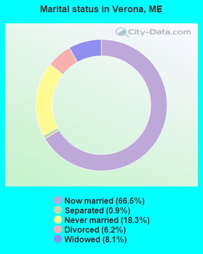
- Never married: 18.3%
- Now married: 66.5%
- Separated: 0.9%
- Widowed: 8.1%
- Divorced: 6.2%
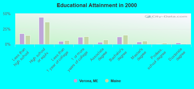
For population 25 years and over in Verona:
- High school or higher: 82.5%
- Bachelor's degree or higher: 18.5%
- Graduate or professional degree: 6.5%
- Unemployed: 4.4%
- Mean travel time to work (commute): 23.0 minutes
| Here: | 11.2 |
| Maine average: | 11.2 |


Graphs represent county-level data. Detailed 2008 Election Results
Religion statistics for Verona, ME (based on Hancock County data)


| Religion | Adherents | Congregations |
|---|---|---|
| Mainline Protestant | 4,691 | 58 |
| Catholic | 2,523 | 9 |
| Evangelical Protestant | 1,288 | 23 |
| Other | 820 | 11 |
| None | 45,096 | - |
Food Environment Statistics:
| Hancock County: | 6.01 / 10,000 pop. |
| Maine: | 2.80 / 10,000 pop. |
| Hancock County: | 1.69 / 10,000 pop. |
| Maine: | 2.20 / 10,000 pop. |
| Hancock County: | 4.89 / 10,000 pop. |
| Maine: | 5.75 / 10,000 pop. |
| This county: | 21.61 / 10,000 pop. |
| Maine: | 11.02 / 10,000 pop. |
| Hancock County: | 7.4% |
| State: | 8.2% |
| Hancock County: | 25.4% |
| Maine: | 25.0% |
Strongest AM radio stations in Verona:
- WABI (910 AM; 5 kW; BANGOR, ME; Owner: CLEAR CHANNEL BROADCASTING LICENSES, INC.)
- WZON (620 AM; 5 kW; BANGOR, ME; Owner: THE ZONE CORPORATION)
- WDEA (1370 AM; 5 kW; ELLSWORTH, ME; Owner: CUMULUS LICENSING CORP.)
- WSKW (1160 AM; 10 kW; SKOWHEGAN, ME; Owner: MOUNTAIN WIRELESS, INCORPORATED)
- WRKO (680 AM; 50 kW; BOSTON, MA; Owner: ENTERCOM BOSTON LICENSE, LLC)
- WTME (780 AM; 10 kW; RUMFORD, ME; Owner: MOUNTAIN VALLEY BROADCASTING, INC.)
- WEEI (850 AM; 50 kW; BOSTON, MA; Owner: ENTERCOM BOSTON LICENSE, LLC)
- WNZS (1340 AM; 1 kW; VEAZIE, ME; Owner: WATERFRONT COMMUNICATIONS INC.)
- WBZ (1030 AM; 50 kW; BOSTON, MA; Owner: INFINITY BROADCASTING OPERATIONS, INC.)
- WFAU (1280 AM; 5 kW; GARDINER, ME; Owner: CAPSTAR TX LIMITED PARTNERSHIP)
- WCRN (830 AM; 50 kW; WORCESTER, MA; Owner: CARTER BROADCASTING CORPORATION)
- WNNZ (640 AM; 50 kW; WESTFIELD, MA; Owner: CLEAR CHANNEL BROADCASTING LICENSES, INC.)
- WMTW (870 AM; 10 kW; GORHAM, ME; Owner: RADIO PARTNERS OF MAINE, L.P.)
Strongest FM radio stations in Verona:
- WBFB (104.7 FM; BELFAST, ME; Owner: CLEAR CHANNEL BROADCASTING LICENSES, INC.)
- WFZX (101.7 FM; SEARSPORT, ME; Owner: CLEAR CHANNEL BROADCASTING LICENSES, INC.)
- WKIT-FM (100.3 FM; BREWER, ME; Owner: THE ZONE CORPORATION)
- WWMJ (95.7 FM; ELLSWORTH, ME; Owner: CUMULUS LICENSING CORP.)
- WERU-FM (89.9 FM; BLUE HILL, ME; Owner: SALT POND COMMUNITY B/C COMPANY)
- WWBX (97.1 FM; BANGOR, ME; Owner: CLEAR CHANNEL BROADCASTING LICENSES, INC.)
- WMEH (90.9 FM; BANGOR, ME; Owner: MAINE PUBLIC BROADCASTING CORPORATION)
- WEZQ (92.9 FM; BANGOR, ME; Owner: CUMULUS LICENSING CORP.)
- WMEP (90.5 FM; CAMDEN, ME; Owner: MAINE PUBLIC BROADCASTING CORP.)
- WQSS (102.5 FM; CAMDEN, ME; Owner: CLEAR CHANNEL BROADCASTING LICENSES, INC.)
- WHCF (88.5 FM; BANGOR, ME; Owner: BANGOR BAPTIST CHURCH)
- WVOM (103.9 FM; HOWLAND, ME; Owner: CLEAR CHANNEL BROADCASTING LICENSES, INC.)
- WNSX (97.7 FM; WINTER HARBOR, ME; Owner: CLEAR CHANNEL BROADCASTING LICENSES, INC.)
- WQCB (106.5 FM; BREWER, ME; Owner: CUMULUS LICENSING CORP.)
- WMCM (103.3 FM; ROCKLAND, ME; Owner: CLEAR CHANNEL BROADCASTING LICENSES, INC.)
- WLKE (99.1 FM; BAR HARBOR, ME; Owner: CLEAR CHANNEL BROADCASTING LICENSES, INC.)
- WBYA (105.5 FM; ISLESBORO, ME; Owner: MARINER BROADCASTING LIMTED PARTNERSHIP)
- WBQX (106.9 FM; THOMASTON, ME; Owner: MARINER BROADCASTING LIMITED PARTNER)
- WBZN (107.3 FM; OLD TOWN, ME; Owner: CUMULUS LICENSING CORP.)
TV broadcast stations around Verona:
- WCKD-LP (Channel 30; BANGOR/DEDHAM, ME; Owner: J. MCLEOD, ME FAMILY B/CING., INC.)
- WABI-TV (Channel 5; BANGOR, ME; Owner: COMMUNITY BROADCASTING SERVICE)
- WLBZ (Channel 2; BANGOR, ME; Owner: PACIFIC AND SOUTHERN COMPANY, INC.)
- WBGR-LP (Channel 33; BANGOR/DEDHAM, ME; Owner: MAINE FAMILY BROADCASTING, INC.)
- WMEB-TV (Channel 12; ORONO, ME; Owner: MAINE PUBLIC BROADCASTING CORPORATION)
- W36CK (Channel 36; BANGOR, ME; Owner: TRINITY BROADCASTING NETWORK)
- W66CL (Channel 66; BANGOR, ME; Owner: MS COMMUNICATIONS, LLC)
Verona fatal accident list:
Sep 19, 2012 07:00 AM, Us-1a, Lat: 44.553658, Lon: -68.864467, Vehicles: 2, Persons: 2, Fatalities: 1
Feb 11, 2008 10:18 PM, I-95, Lat: 44.568730, Lon: -68.788710, Vehicles: 2, Persons: 2, Fatalities: 1
Sep 29, 1993 11:25 PM, 1, Vehicles: 1, Persons: 3, Fatalities: 1, Drunk persons involved: 1
Jul 12, 1986 11:55 PM, 20622064, Vehicles: 1, Persons: 1, Fatalities: 1, Drunk persons involved: 1
- National Bridge Inventory (NBI) Statistics
- 1Number of bridges
- 72ft / 22.1mTotal length
- 10,092Total average daily traffic
- 504Total average daily truck traffic
- 14,129Total future (year 2036) average daily traffic
FCC Registered Broadcast Land Mobile Towers:
1- PENOB CROSSING BRIDG, Penob Crossing Bridge (Lat: 44.558750 Lon: -68.798833), Type: Bridg, Structure height: 447.2 m, Call Sign: WQGU281,
Assigned Frequencies: 453.300 MHz, Grant Date: 04/13/2017, Expiration Date: 04/17/2027, Registrant: State Of Maine, O.I.T., Radio Operations, 66 Industrial Drive, Augusta, ME 04333-0147, Phone: (207) 624-9990, Email:
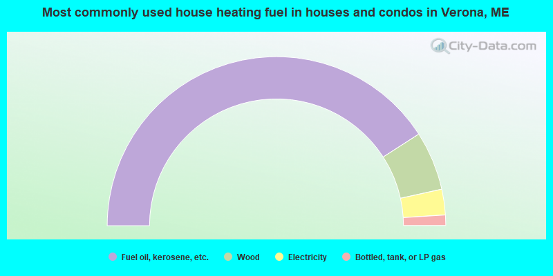
- 81.8%Fuel oil, kerosene, etc.
- 11.3%Wood
- 4.9%Electricity
- 2.0%Bottled, tank, or LP gas
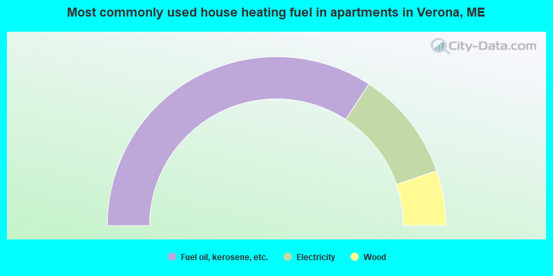
- 68.4%Fuel oil, kerosene, etc.
- 21.1%Electricity
- 10.5%Wood
Verona compared to Maine state average:
- Unemployed percentage significantly below state average.
- Black race population percentage significantly below state average.
- Hispanic race population percentage significantly below state average.
- Renting percentage significantly below state average.
- Length of stay since moving in significantly above state average.
- Number of rooms per house significantly below state average.
- House age significantly below state average.