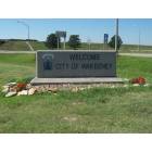
WaKeeney, Kansas

Submit your own pictures of this city and show them to the world
- OSM Map
- General Map
- Google Map
- MSN Map
Population change since 2000: -8.7%
 |
| Males: 905 | |
| Females: 852 |
| Median resident age: | 45.3 years |
| Kansas median age: | 37.6 years |
Zip codes: 67672.
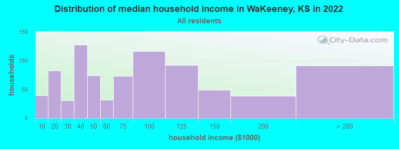
| WaKeeney: | $64,125 |
| KS: | $68,925 |
Estimated per capita income in 2022: $44,708 (it was $17,596 in 2000)
WaKeeney city income, earnings, and wages data
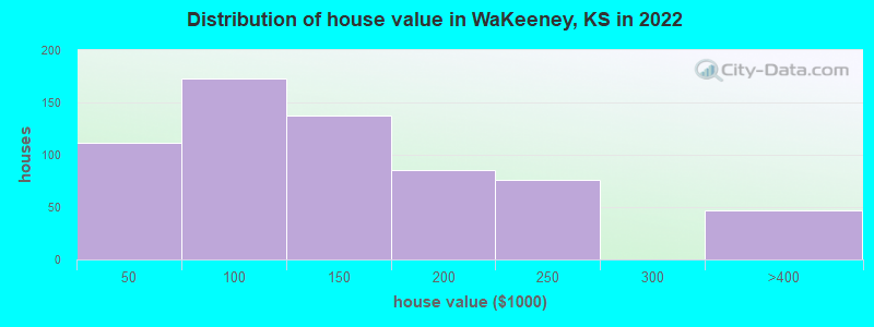
Estimated median house or condo value in 2022: $117,652 (it was $49,200 in 2000)
| WaKeeney: | $117,652 |
| KS: | $206,600 |
Median gross rent in 2022: $645.
(8.6% for White Non-Hispanic residents, 90.0% for Hispanic or Latino residents, 20.0% for two or more races residents)
Detailed information about poverty and poor residents in WaKeeney, KS
Compare current foreclosures near your location:
| Photo | Address | Area | Beds / Baths | Price | Details |
|---|---|---|---|---|---|

|
#1
Bayberry Cir
Columbus, OH 43207
|
1,564 sq. feet
|
1 baths 3 beds |
$127,500
|
show details |

|
#2
E 21st Ave
Columbus, OH 43211
|
1,061 sq. feet
|
1 baths 3 beds |
$187,900
|
show details |

|
#3
Stoneybrook Blvd # 21a
Hilliard, OH 43026
|
1,231 sq. feet
|
2 baths 3 beds |
show details | |

|
#4
Bernadette Rd
Columbus, OH 43204
|
1,168 sq. feet
|
1 baths 3 beds |
show details | |

|
#5
Ferris Rd
Columbus, OH 43224
|
2,218 sq. feet
|
3 baths 3 beds |
show details | |

|
#6
S Ashburton Rd
Columbus, OH 43213
|
1,220 sq. feet
|
1 baths 3 beds |
show details | |

|
#7
Sleeping Meadow Dr
New Albany, OH 43054
|
3,211 sq. feet
|
2 baths 4 beds |
show details | |

|
#8
Vineyard Haven Loop
Dublin, OH 43016
|
4,625 sq. feet
|
4 baths 4 beds |
show details | |

|
#9
Mcguffey Rd
Columbus, OH 43224
|
672 sq. feet
|
1 baths 2 beds |
show details | |

|
#10
Hiawatha Park Dr
Columbus, OH 43211
|
1,278 sq. feet
|
1 baths 4 beds |
show details |
| Photo | Address | Area | Beds / Baths | Price | Details |
|---|---|---|---|---|---|

|
#11
Brookstone Dr
Westerville, OH 43082
|
1,783 sq. feet
|
3 baths 3 beds |
show details | |

|
#12
N Roys Ave
Columbus, OH 43204
|
1,248 sq. feet
|
2 baths 3 beds |
show details | |

|
#13
Franklin Ave
Columbus, OH 43205
|
2,925 sq. feet
|
2 baths 4 beds |
show details | |

|
#14
Marshrun Dr
Grove City, OH 43123
|
2,036 sq. feet
|
2 baths 4 beds |
show details | |

|
#15
S Hague Ave
Columbus, OH 43204
|
979 sq. feet
|
1 baths 2 beds |
show details | |

|
#16
E Welch Ave
Columbus, OH 43207
|
1,864 sq. feet
|
2 baths 3 beds |
show details | |

|
#17
Kingsglen Dr
Grove City, OH 43123
|
1,635 sq. feet
|
2 baths 4 beds |
show details | |

|
#18
Gladiolus Ct
Reynoldsburg, OH 43068
|
2,208 sq. feet
|
2 baths 3 beds |
show details | |

|
#19
Blue Lake Ave
Galloway, OH 43119
|
1,540 sq. feet
|
2 baths 3 beds |
show details | |

|
#20
Derrer Rd -872
Columbus, OH 43204
|
1,667 sq. feet
|
2 baths 5 beds |
show details |
| Photo | Address | Area | Beds / Baths | Price | Details |
|---|---|---|---|---|---|

|
#21
Elaine Rd
Columbus, OH 43213
|
764 sq. feet
|
1 baths 2 beds |
show details | |

|
#22
Midland Ave
Columbus, OH 43223
|
1,518 sq. feet
|
1 baths 2 beds |
show details | |

|
#23
Mayflower Blvd
Columbus, OH 43213
|
1,591 sq. feet
|
2 baths 4 beds |
show details | |

|
#24
S Richardson Ave
Columbus, OH 43204
|
1,520 sq. feet
|
2 baths 3 beds |
show details | |

|
#25
Rosewood Ct
Powell, OH 43065
|
2,801 sq. feet
|
3 baths 4 beds |
show details | |

|
#26
N Grener Ave
Columbus, OH 43228
|
1,120 sq. feet
|
1 baths 3 beds |
show details | |

|
#27
Stone Shadow Dr
Blacklick, OH 43004
|
1,640 sq. feet
|
2 baths 3 beds |
show details | |

|
#28
Spohn Dr
Westerville, OH 43081
|
1,040 sq. feet
|
1 baths 3 beds |
show details | |

|
#29
Bretton Pl
Columbus, OH 43211
|
1,056 sq. feet
|
1 baths 3 beds |
show details | |

|
#30
High Free Pike
West Jefferson, OH 43162
|
1,216 sq. feet
|
2 baths 4 beds |
show details |
| Photo | Address | Area | Beds / Baths | Price | Details |
|---|---|---|---|---|---|

|
#31
Traci Ct
Columbus, OH 43207
|
925 sq. feet
|
3 baths 3 beds |
show details | |

|
#32
S Chillicothe St
Plain City, OH 43064
|
1,736 sq. feet
|
2 baths 4 beds |
show details | |

|
#33
Belle Oak Dr
Galloway, OH 43119
|
1,296 sq. feet
|
2 baths 3 beds |
show details | |

|
#34
Arborlee Dr
Reynoldsburg, OH 43068
|
1,263 sq. feet
|
2 baths 3 beds |
show details | |

|
#35
Mink St SW
Pataskala, OH 43062
|
1,442 sq. feet
|
1 baths 3 beds |
show details | |

|
#36
Falls Peak Ln
Delaware, OH 43015
|
1,352 sq. feet
|
2 baths 2 beds |
show details | |

|
#37
Meadowbrook Dr
Columbus, OH 43207
|
1,752 sq. feet
|
2 baths 4 beds |
show details | |

|
#38
Scottwood Rd
Columbus, OH 43227
|
1,008 sq. feet
|
1 baths 3 beds |
show details | |

|
#39
Minerva Ave
Columbus, OH 43229
|
2,008 sq. feet
|
3 baths 4 beds |
show details | |

|
#40
Omega Dr
Columbus, OH 43231
|
1,292 sq. feet
|
2 baths 3 beds |
show details |
| Photo | Address | Area | Beds / Baths | Price | Details |
|---|---|---|---|---|---|

|
#41
Greenhaven Ave
Galloway, OH 43119
|
1,986 sq. feet
|
2 baths 4 beds |
show details | |

|
#42
Dimson Dr S
Columbus, OH 43213
|
1,054 sq. feet
|
1 baths 3 beds |
show details | |

|
#43
Alder Vista Dr
Columbus, OH 43231
|
1,377 sq. feet
|
1 baths 2 beds |
show details | |

|
#44
Mayflower Cir
Grove City, OH 43123
|
2,084 sq. feet
|
2 baths 4 beds |
show details | |

|
#45
Rio Grande Ave
Groveport, OH 43125
|
1,056 sq. feet
|
1 baths 3 beds |
show details | |

|
#46
Omega Dr
Columbus, OH 43231
|
1,276 sq. feet
|
2 baths 3 beds |
show details | |

|
#47
Blaine Dr
Columbus, OH 43227
|
1,294 sq. feet
|
1 baths 3 beds |
show details | |

|
#48
Wallcrest Blvd
Columbus, OH 43231
|
2,152 sq. feet
|
2 baths 3 beds |
show details | |

|
#49
Oklahoma Ave
Columbus, OH 43230
|
1,824 sq. feet
|
1 baths 4 beds |
show details | |

|
Check over 1 million property listings on Foreclosure.com!
|
browse all offers | |||


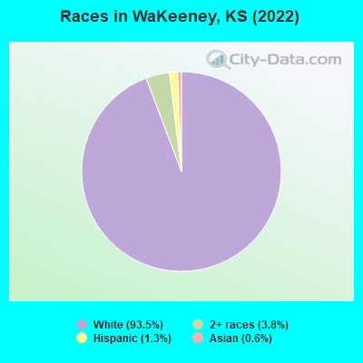
- 1,68493.5%White alone
- 683.8%Two or more races
- 231.3%Hispanic
- 100.6%Asian alone
- 10.06%American Indian alone
Races in WaKeeney detailed stats: ancestries, foreign born residents, place of birth
According to our research of Kansas and other state lists, there were 4 registered sex offenders living in WaKeeney, Kansas as of April 19, 2024.
The ratio of all residents to sex offenders in WaKeeney is 518 to 1.
The ratio of registered sex offenders to all residents in this city is lower than the state average.
Type |
2009 |
2010 |
2011 |
2012 |
2013 |
2014 |
2015 |
2016 |
2017 |
2019 |
2020 |
2021 |
2022 |
|---|---|---|---|---|---|---|---|---|---|---|---|---|---|
| Murders (per 100,000) | 0 (0.0) | 0 (0.0) | 0 (0.0) | 0 (0.0) | 0 (0.0) | 0 (0.0) | 0 (0.0) | 0 (0.0) | 0 (0.0) | 0 (0.0) | 0 (0.0) | 0 (0.0) | 0 (0.0) |
| Rapes (per 100,000) | 0 (0.0) | 0 (0.0) | 1 (53.4) | 1 (54.7) | 0 (0.0) | 0 (0.0) | 1 (56.1) | 0 (0.0) | 0 (0.0) | 0 (0.0) | 0 (0.0) | 0 (0.0) | 0 (0.0) |
| Robberies (per 100,000) | 0 (0.0) | 0 (0.0) | 0 (0.0) | 0 (0.0) | 0 (0.0) | 0 (0.0) | 0 (0.0) | 0 (0.0) | 0 (0.0) | 0 (0.0) | 0 (0.0) | 0 (0.0) | 0 (0.0) |
| Assaults (per 100,000) | 0 (0.0) | 2 (107.4) | 3 (160.1) | 1 (54.7) | 0 (0.0) | 2 (108.5) | 1 (56.1) | 3 (166.4) | 1 (56.7) | 3 (174.1) | 10 (571.1) | 5 (290.0) | 0 (0.0) |
| Burglaries (per 100,000) | 5 (295.5) | 3 (161.1) | 2 (106.7) | 2 (109.5) | 2 (108.0) | 4 (216.9) | 3 (168.3) | 7 (388.2) | 0 (0.0) | 0 (0.0) | 4 (228.4) | 4 (232.0) | 1 (56.2) |
| Thefts (per 100,000) | 13 (768.3) | 9 (483.4) | 7 (373.5) | 15 (821.0) | 12 (647.9) | 12 (650.8) | 7 (392.6) | 16 (887.4) | 1 (56.7) | 0 (0.0) | 18 (1,028) | 2 (116.0) | 4 (224.7) |
| Auto thefts (per 100,000) | 0 (0.0) | 1 (53.7) | 0 (0.0) | 1 (54.7) | 2 (108.0) | 0 (0.0) | 0 (0.0) | 2 (110.9) | 2 (113.4) | 0 (0.0) | 3 (171.3) | 2 (116.0) | 1 (56.2) |
| Arson (per 100,000) | 0 (0.0) | 0 (0.0) | 0 (0.0) | 1 (54.7) | 0 (0.0) | 0 (0.0) | 0 (0.0) | 1 (55.5) | 0 (0.0) | 0 (0.0) | 0 (0.0) | 0 (0.0) | 1 (56.2) |
| City-Data.com crime index | 51.4 | 56.4 | 97.1 | 99.6 | 42.1 | 62.9 | 83.6 | 104.8 | 22.7 | 34.8 | 185.0 | 88.2 | 17.4 |
The City-Data.com crime index weighs serious crimes and violent crimes more heavily. Higher means more crime, U.S. average is 246.1. It adjusts for the number of visitors and daily workers commuting into cities.
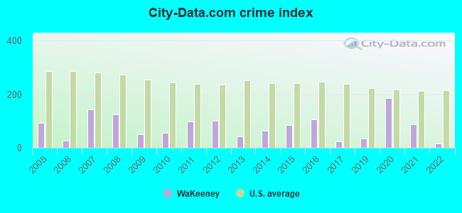
Crime rate in WaKeeney detailed stats: murders, rapes, robberies, assaults, burglaries, thefts, arson
Full-time law enforcement employees in 2021, including police officers: 5 (5 officers - 4 male; 1 female).
| Officers per 1,000 residents here: | 2.90 |
| Kansas average: | 2.70 |
 Recent articles from our blog. Our writers, many of them Ph.D. graduates or candidates, create easy-to-read articles on a wide variety of topics.

 | Interesting things in western Kansas other than farms and ranches? (16 replies) |
| What the hell is up with all the stopping on I-70 from Denver? (63 replies) |
| Non-KC Area Kansans Perspectives (41 replies) |
Latest news from WaKeeney, KS collected exclusively by city-data.com from local newspapers, TV, and radio stations
Ancestries: German (67.0%), Irish (5.3%), American (5.2%), English (4.5%), Eastern European (1.8%), Swedish (1.7%).
Current Local Time: CST time zone
Elevation: 2465 feet
Land area: 1.71 square miles.
Population density: 1,027 people per square mile (low).
12 residents are foreign born
| This city: | 0.7% |
| Kansas: | 7.1% |
Median real estate property taxes paid for housing units with mortgages in 2022: $2,645 (1.9%)
Median real estate property taxes paid for housing units with no mortgage in 2022: $1,318 (1.6%)
Nearest city with pop. 50,000+: Wichita, KS  (166.1 miles , pop. 344,284).
Nearest city with pop. 1,000,000+: Dallas, TX (464.1 miles , pop. 1,188,580).
Nearest cities:
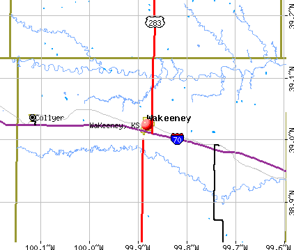
Latitude: 39.02 N, Longitude: 99.88 W
Area code commonly used in this area: 785
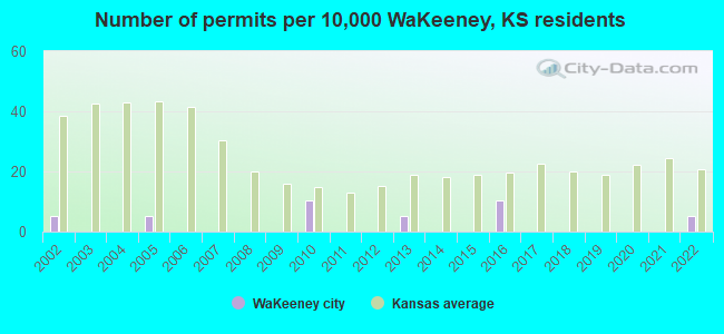
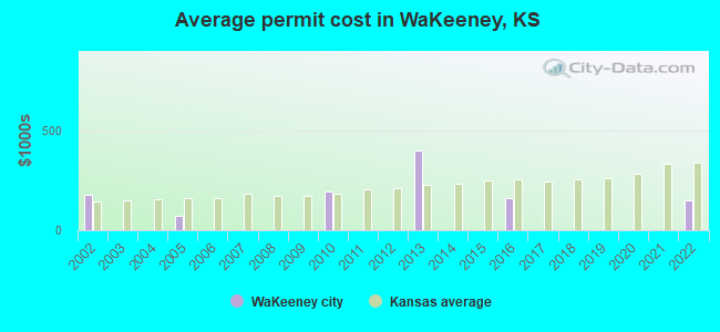
Single-family new house construction building permits:
- 2022: 1 building, cost: $150,000
- 2016: 2 buildings, average cost: $162,500
- 2013: 1 building, cost: $400,000
- 2010: 2 buildings, average cost: $192,500
- 2005: 1 building, cost: $75,000
- 2002: 1 building, cost: $180,000
| Here: | 2.0% |
| Kansas: | 2.0% |
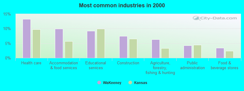
- Health care (13.2%)
- Accommodation & food services (9.9%)
- Educational services (9.2%)
- Construction (7.5%)
- Agriculture, forestry, fishing & hunting (6.3%)
- Public administration (4.2%)
- Food & beverage stores (3.4%)
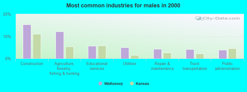
- Construction (15.3%)
- Agriculture, forestry, fishing & hunting (12.1%)
- Educational services (5.7%)
- Utilities (5.0%)
- Repair & maintenance (4.3%)
- Truck transportation (4.1%)
- Public administration (3.9%)
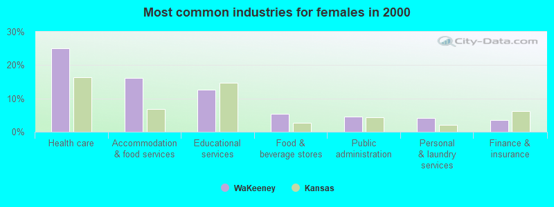
- Health care (25.0%)
- Accommodation & food services (16.1%)
- Educational services (12.6%)
- Food & beverage stores (5.4%)
- Public administration (4.6%)
- Personal & laundry services (4.1%)
- Finance & insurance (3.5%)
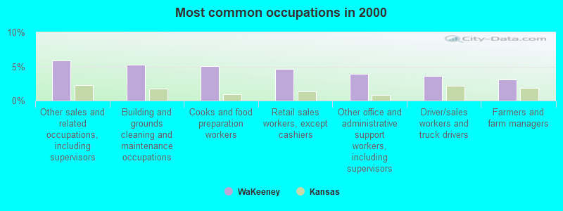
- Other sales and related occupations, including supervisors (5.9%)
- Building and grounds cleaning and maintenance occupations (5.2%)
- Cooks and food preparation workers (5.0%)
- Retail sales workers, except cashiers (4.7%)
- Other office and administrative support workers, including supervisors (3.9%)
- Driver/sales workers and truck drivers (3.6%)
- Farmers and farm managers (3.1%)
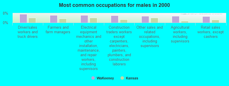
- Driver/sales workers and truck drivers (7.3%)
- Farmers and farm managers (6.4%)
- Electrical equipment mechanics and other installation, maintenance, and repair workers, including supervisors (6.4%)
- Construction traders workers except carpenters, electricians, painters, plumbers, and construction laborers (6.2%)
- Other sales and related occupations, including supervisors (5.7%)
- Agricultural workers, including supervisors (5.7%)
- Retail sales workers, except cashiers (5.2%)
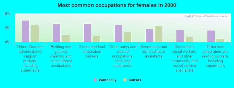
- Other office and administrative support workers, including supervisors (7.6%)
- Building and grounds cleaning and maintenance occupations (6.5%)
- Cooks and food preparation workers (6.5%)
- Other sales and related occupations, including supervisors (6.1%)
- Secretaries and administrative assistants (4.6%)
- Counselors, social workers, and other community and social service specialists (4.3%)
- Other food preparation and serving workers, including supervisors (4.1%)
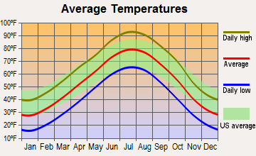
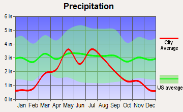
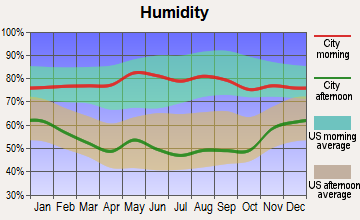
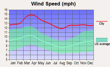
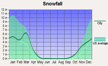
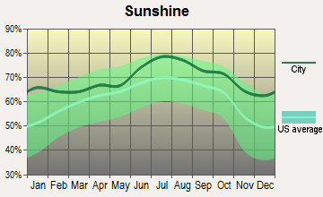
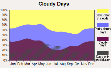
Average climate in WaKeeney, Kansas
Based on data reported by over 4,000 weather stations
|
|

(lower is better)
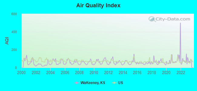
Air Quality Index (AQI) level in 2022 was 75.9. This is about average.
| City: | 75.9 |
| U.S.: | 72.6 |
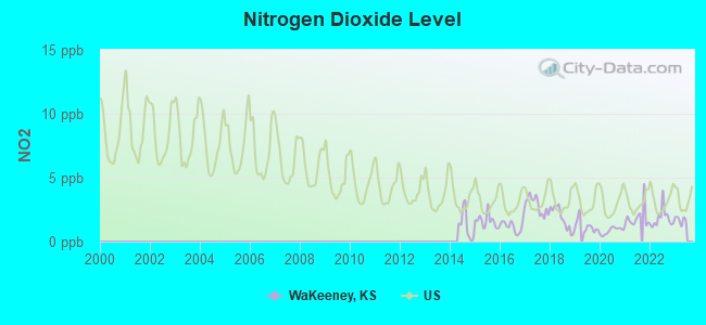
Nitrogen Dioxide (NO2) [ppb] level in 2022 was 1.81. This is significantly better than average. Closest monitor was 18.7 miles away from the city center.
| City: | 1.81 |
| U.S.: | 5.11 |
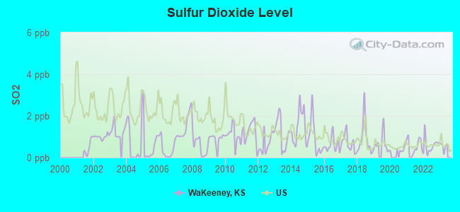
Sulfur Dioxide (SO2) [ppb] level in 2022 was 0.567. This is significantly better than average. Closest monitor was 18.7 miles away from the city center.
| City: | 0.567 |
| U.S.: | 1.515 |
Ozone [ppb] level in 2022 was 31.9. This is about average. Closest monitor was 18.7 miles away from the city center.
| City: | 31.9 |
| U.S.: | 33.3 |
Particulate Matter (PM10) [µg/m3] level in 2022 was 27.3. This is significantly worse than average. Closest monitor was 18.7 miles away from the city center.
| City: | 27.3 |
| U.S.: | 19.2 |

Particulate Matter (PM2.5) [µg/m3] level in 2022 was 7.24. This is about average. Closest monitor was 18.7 miles away from the city center.
| City: | 7.24 |
| U.S.: | 8.11 |
Tornado activity:
WaKeeney-area historical tornado activity is slightly below Kansas state average. It is 67% greater than the overall U.S. average.
On 6/27/1951, a category F4 (max. wind speeds 207-260 mph) tornado 0.4 miles away from the WaKeeney city center killed 5 people and injured 100 people and caused between $500,000 and $5,000,000 in damages.
On 5/23/2008, a category F4 tornado 22.7 miles away from the city center injured 2 people and caused $3 million in damages.
Earthquake activity:
WaKeeney-area historical earthquake activity is significantly above Kansas state average. It is 604% greater than the overall U.S. average.On 9/3/2016 at 12:02:44, a magnitude 5.8 (5.8 MW, Depth: 3.5 mi, Class: Moderate, Intensity: VI - VII) earthquake occurred 241.7 miles away from the city center
On 6/22/2019 at 08:50:24, a magnitude 4.6 (4.6 MW, Depth: 1.9 mi, Class: Light, Intensity: IV - V) earthquake occurred 27.8 miles away from WaKeeney center
On 11/6/2011 at 03:53:10, a magnitude 5.7 (5.7 MW, Depth: 3.2 mi) earthquake occurred 296.2 miles away from the city center
On 2/13/2016 at 17:07:06, a magnitude 5.1 (5.1 MW, Depth: 5.2 mi) earthquake occurred 186.7 miles away from WaKeeney center
On 11/12/2014 at 21:40:00, a magnitude 4.9 (4.9 MW, Depth: 2.5 mi) earthquake occurred 172.7 miles away from WaKeeney center
On 1/19/2020 at 19:08:42, a magnitude 4.5 (4.5 MW, Depth: 3.1 mi) earthquake occurred 124.3 miles away from WaKeeney center
Magnitude types: moment magnitude (MW)
Natural disasters:
The number of natural disasters in Trego County (9) is smaller than the US average (15).Major Disasters (Presidential) Declared: 5
Emergencies Declared: 2
Causes of natural disasters: Winter Storms: 4, Floods: 3, Storms: 3, Tornadoes: 2, Hurricane: 1, Other: 1 (Note: some incidents may be assigned to more than one category).
Hospitals and medical centers in WaKeeney:
Airports located in WaKeeney:
- Trego Wakeeney Airport (0H1) (Runways: 1, Air Taxi Ops: 100, Itinerant Ops: 900, Local Ops: 1,000)
Colleges/universities with over 2000 students nearest to WaKeeney:
- Fort Hays State University (about 31 miles; Hays, KS; Full-time enrollment: 8,728)
- Barton County Community College (about 76 miles; Great Bend, KS; FT enrollment: 4,108)
- University of Nebraska at Kearney (about 124 miles; Kearney, NE; FT enrollment: 6,047)
- Hutchinson Community College (about 126 miles; Hutchinson, KS; FT enrollment: 4,174)
- Central Community College (about 152 miles; Grand Island, NE; FT enrollment: 4,159)
- Newman University (about 165 miles; Wichita, KS; FT enrollment: 2,066)
- Friends University (about 166 miles; Wichita, KS; FT enrollment: 2,024)
Public high school in WaKeeney:
- TREGO COMMUNITY HIGH (Students: 138, Location: 1200 RUSSELL AVENUE, Grades: 9-12)
Public elementary/middle school in WaKeeney:
- TREGO GRADE SCHOOL (Students: 278, Location: 612 JUNCTION AVENUE, Grades: PK-8)
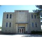
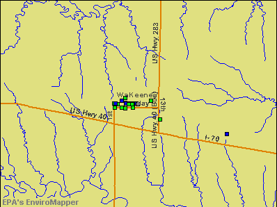
Points of interest:
Notable locations in WaKeeney: WaKeeney Kampgrounds of America (A), Wakeeney Speedway (B), Trego County Fairgrounds (C), Frontier Agricultural Grain Elevator Number 25 (D), Trego County Sheriff's Department (E), Kansas Highway Patrol Troop D - Trego (F), Trego County Courthouse (G), Wakeeney Police Department (H), Wakeeney Fire Department (I), Trego County Rural Fire Department Station 1 (J), Trego County Sheriff's Department Jail (K), Trego County Detention Center / Juvenile Detention Center (L), Trego County Emergency Medical Services (M), Trego County Health Department (N), Wakeeney Public Library (O), Trego County Museum (P), Wakeeney City Hall (Q), Trego County Senior Center (R), Trego County Fair Exhibit Building (S). Display/hide their locations on the map
Churches in WaKeeney include: WaKeeney United Methodist Church (A), Bethany Baptist Church (B), Bethlehem Lutheran Church (C), Harvestime Assembly of God Church (D), Immanuel Lutheran Church (E), WaKeeney Church of God (F), WaKeeney Presbyterian Church (G), Christ the King Catholic Church (H). Display/hide their locations on the map
Cemetery: Wakeeney City Cemetery (1). Display/hide its location on the map
Birthplace of: Steve Gotsche - Professional golfer.
| This city: | 2.1 people |
| Kansas: | 2.5 people |
| This city: | 57.9% |
| Whole state: | 66.0% |
| This city: | 5.4% |
| Whole state: | 5.8% |
Likely homosexual households (counted as self-reported same-sex unmarried-partner households)
- Lesbian couples: 0.1% of all households
- Gay men: 0.1% of all households
34 people in nursing homes in 2000
For population 15 years and over in WaKeeney:
- Never married: 20.7%
- Now married: 62.2%
- Separated: 0.5%
- Widowed: 9.3%
- Divorced: 7.2%
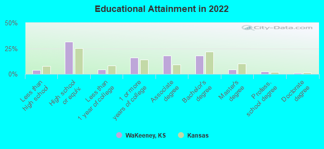
For population 25 years and over in WaKeeney:
- High school or higher: 95.6%
- Bachelor's degree or higher: 25.0%
- Graduate or professional degree: 7.3%
- Unemployed: 2.8%
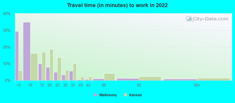
- Mean travel time to work (commute): 15.8 minutes
| Here: | 8.2 |
| Kansas average: | 11.5 |
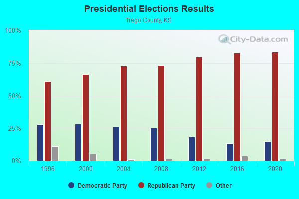
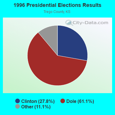
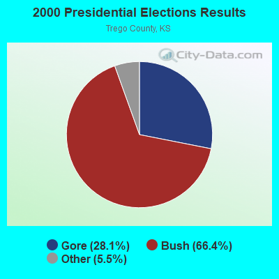

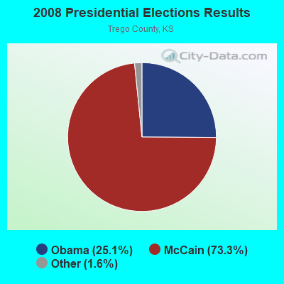
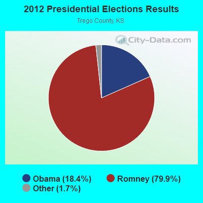
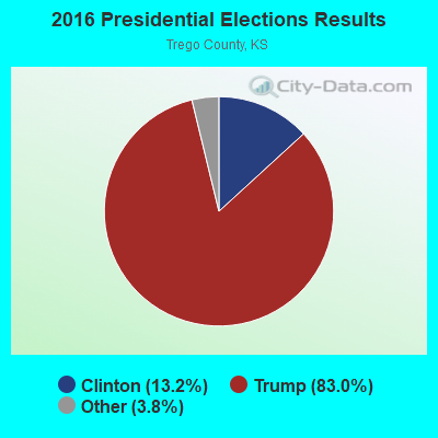
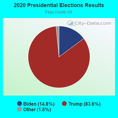
Graphs represent county-level data. Detailed 2008 Election Results
Religion statistics for WaKeeney, KS (based on Trego County data)
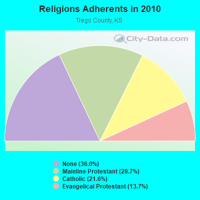
| Religion | Adherents | Congregations |
|---|---|---|
| Mainline Protestant | 861 | 6 |
| Catholic | 648 | 2 |
| Evangelical Protestant | 410 | 5 |
| Other | 3 | - |
| None | 1,079 | - |
Food Environment Statistics:
| Here: | 3.44 / 10,000 pop. |
| State: | 1.96 / 10,000 pop. |
| Trego County: | 24.09 / 10,000 pop. |
| Kansas: | 3.84 / 10,000 pop. |
| Trego County: | 10.32 / 10,000 pop. |
| Kansas: | 7.33 / 10,000 pop. |
| Trego County: | 10.2% |
| State: | 8.1% |
| Trego County: | 28.8% |
| Kansas: | 27.9% |
Health and Nutrition:
| Here: | 51.2% |
| Kansas: | 49.2% |
| WaKeeney: | 45.4% |
| Kansas: | 46.3% |
| This city: | 28.9 |
| Kansas: | 28.6 |
| This city: | 19.9% |
| Kansas: | 21.2% |
| Here: | 7.0% |
| State: | 10.5% |
| This city: | 6.9 |
| State: | 6.8 |
| WaKeeney: | 31.0% |
| Kansas: | 33.5% |
| WaKeeney: | 57.3% |
| Kansas: | 56.0% |
| This city: | 73.6% |
| State: | 78.6% |
More about Health and Nutrition of WaKeeney, KS Residents
| Local government employment and payroll (March 2022) | |||||
| Function | Full-time employees | Monthly full-time payroll | Average yearly full-time wage | Part-time employees | Monthly part-time payroll |
|---|---|---|---|---|---|
| Streets and Highways | 5 | $15,887 | $38,129 | 0 | $0 |
| Police Protection - Officers | 5 | $25,853 | $62,047 | 0 | $0 |
| Water Supply | 3 | $15,053 | $60,212 | 0 | $0 |
| Financial Administration | 2 | $12,743 | $76,458 | 0 | $0 |
| Local Libraries | 2 | $3,633 | $21,798 | 5 | $1,546 |
| Parks and Recreation | 1 | $3,127 | $37,524 | 1 | $1,968 |
| Firefighters | 0 | $0 | 4 | $2,463 | |
| Judicial and Legal | 0 | $0 | 2 | $1,858 | |
| Other Government Administration | 0 | $0 | 11 | $8,944 | |
| Airports | 0 | $0 | 1 | $1,527 | |
| Totals for Government | 18 | $76,296 | $50,864 | 24 | $18,306 |
WaKeeney government finances - Expenditure in 2017 (per resident):
- Current Operations - Central Staff Services: $513,000 ($291.97)
Water Utilities: $240,000 ($136.60)
Solid Waste Management: $172,000 ($97.89)
Police Protection: $102,000 ($58.05)
Housing and Community Development: $88,000 ($50.09)
General - Other: $78,000 ($44.39)
Sewerage: $71,000 ($40.41)
Libraries: $66,000 ($37.56)
Regular Highways: $53,000 ($30.17)
Local Fire Protection: $43,000 ($24.47)
Parks and Recreation: $27,000 ($15.37)
Transit Utilities: $26,000 ($14.80)
- General - Interest on Debt: $115,000 ($65.45)
- Intergovernmental to Local - Other - Air Transportation: $3,000 ($1.71)
- Intergovernmental to State - Water Utilities: $8,000 ($4.55)
- Other Capital Outlay - Regular Highways: $69,000 ($39.27)
Water Utilities: $8,000 ($4.55)
Parks and Recreation: $6,000 ($3.41)
- Total Salaries and Wages: $709,000 ($403.53)
WaKeeney government finances - Revenue in 2017 (per resident):
- Charges - Sewerage: $273,000 ($155.38)
Solid Waste Management: $173,000 ($98.46)
Parks and Recreation: $26,000 ($14.80)
Miscellaneous Commercial Activities: $5,000 ($2.85)
- Federal Intergovernmental - Housing and Community Development: $72,000 ($40.98)
- Local Intergovernmental - General Local Government Support: $43,000 ($24.47)
Other: $9,000 ($5.12)
Transit Utilities: $2,000 ($1.14)
- Miscellaneous - General Revenue - Other: $47,000 ($26.75)
Fines and Forfeits: $19,000 ($10.81)
Rents: $15,000 ($8.54)
Donations From Private Sources: $7,000 ($3.98)
Interest Earnings: $1,000 ($0.57)
- Revenue - Water Utilities: $376,000 ($214.00)
Transit Utilities: $7,000 ($3.98)
- State Intergovernmental - Highways: $46,000 ($26.18)
General Local Government Support: $9,000 ($5.12)
Other: $7,000 ($3.98)
Transit Utilities: $7,000 ($3.98)
- Tax - Property: $878,000 ($499.72)
General Sales and Gross Receipts: $376,000 ($214.00)
Public Utilities Sales: $245,000 ($139.44)
Other License: $4,000 ($2.28)
WaKeeney government finances - Debt in 2017 (per resident):
- Long Term Debt - Beginning Outstanding - Unspecified Public Purpose: $3,758,000 ($2138.87)
Outstanding Unspecified Public Purpose: $3,534,000 ($2011.38)
Retired Unspecified Public Purpose: $224,000 ($127.49)
WaKeeney government finances - Cash and Securities in 2017 (per resident):
- Other Funds - Cash and Securities: $381,000 ($216.85)
- Sinking Funds - Cash and Securities: $408,000 ($232.21)
| Businesses in WaKeeney, KS | ||||
| Name | Count | Name | Count | |
|---|---|---|---|---|
| Best Western | 1 | Subway | 1 | |
| Dairy Queen | 1 | Super 8 | 1 | |
| Econo Lodge | 1 | True Value | 1 | |
| McDonald's | 1 | UPS | 1 | |
Strongest AM radio stations in WaKeeney:
- KRVN (880 AM; 50 kW; LEXINGTON, NE; Owner: NEBRASKA RURAL RADIO ASSOCIATION)
- KXXX (790 AM; 5 kW; COLBY, KS; Owner: WAITT RADIO, INC.)
- KGYN (1210 AM; 50 kW; GUYMON, OK; Owner: TELNS BROADCASTING COMPANY, INC.)
- KLTT (670 AM; 50 kW; COMMERCE CITY, CO; Owner: KLZ RADIO, INC.)
- KAYS (1400 AM; 1 kW; HAYS, KS; Owner: EAGLE RADIO, INC.)
- KOA (850 AM; 50 kW; DENVER, CO; Owner: JACOR BROADCASTING OF COLORADO, INC.)
- KKZN (760 AM; 50 kW; THORNTON, CO; Owner: JACOR BROADCASTING OF COLORADO, INC.)
- KRMG (740 AM; 50 kW; TULSA, OK; Owner: CXR HOLDINGS, INC.)
- KOIL (1020 AM; 50 kW; PLATTSMOUTH, NE; Owner: WAITT RADIO, INC.)
- WHB (810 AM; 50 kW; KANSAS CITY, MO; Owner: UNION BROADCASTING, INC.)
- KFAB (1110 AM; 50 kW; OMAHA, NE; Owner: CAPSTAR TX LIMITED PARTNERSHIP)
- KMXA (1090 AM; 50 kW; AURORA, CO; Owner: ENTRAVISION HOLDINGS, LLC)
- KIMB (1260 AM; 50 kW; KIMBALL, NE; Owner: G & L INVESTMENTS, LLC)
Strongest FM radio stations in WaKeeney:
- KJLS (103.3 FM; HAYS, KS; Owner: EAGLE RADIO, INC)
- KKQY (101.9 FM; HILL CITY, KS; Owner: EAGLE RADIO, INC)
- KZNA (90.5 FM; HILL CITY, KS; Owner: KANZA SOCIETY, INC)
- KFIX (96.9 FM; PLAINVILLE, KS; Owner: HULL BROADCASTING, INC.)
- KHAZ (99.5 FM; HAYS, KS; Owner: EAGLE RADIO, INC.)
- K207BP (89.3 FM; QUINTER, KS; Owner: GOVE COUNTY TRANSLATOR COMMITTEE)
TV broadcast stations around WaKeeney:
- KBSH-TV (Channel 7; HAYS, KS; Owner: MEDIA GENERAL BROADCASTING OF SO. CAROLINA HOLDINGS, INC.)
WaKeeney fatal accident list:
Nov 29, 2008 05:46 PM, Us-283, 6th, Lat: 39.021380, Lon: -99.882460, Vehicles: 1, Persons: 2, Pedestrians: 1, Fatalities: 1
Jan 17, 2005 01:36 PM, Us-283, Barclay, Lat: 39.022180, Lon: -99.882410, Vehicles: 1, Persons: 1, Fatalities: 1, Drunk persons involved: 1
Jan 8, 1985 08:30 PM, I70, Vehicles: 2, Persons: 3, Fatalities: 1
- National Bridge Inventory (NBI) Statistics
- 21Number of bridges
- 194ft / 58.7mTotal length
- $225,000Total costs
- 71,976Total average daily traffic
- 18,396Total average daily truck traffic
- New bridges - historical statistics
- 11940-1949
- 141950-1959
- 21960-1969
- 21970-1979
- 11990-1999
- 12000-2009
FCC Registered Cell Phone Towers:
5 (See the full list of FCC Registered Cell Phone Towers in WaKeeney)FCC Registered Antenna Towers:
54 (See the full list of FCC Registered Antenna Towers)FCC Registered Broadcast Land Mobile Towers:
9 (See the full list of FCC Registered Broadcast Land Mobile Towers in WaKeeney, KS)FCC Registered Microwave Towers:
15 (See the full list of FCC Registered Microwave Towers in this town)FCC Registered Amateur Radio Licenses:
9 (See the full list of FCC Registered Amateur Radio Licenses in WaKeeney)FAA Registered Aircraft:
1- Aircraft: CESSNA 182K (Category: Land, Seats: 4, Weight: Up to 12,499 Pounds, Speed: 119 mph), Engine: CONT MOTOR O-470 SERIES (230 HP) (Reciprocating)
N-Number: 2643Q, N2643Q, N-2643Q, Serial Number: 18257843, Year manufactured: 1966, Airworthiness Date: 07/01/1985, Certificate Issue Date: 01/04/2018
Registrant (Co-Owned): Richard Hearting, 303 N Main St, Wakeeney, KS 67672, Other Owners: Judy Hearting
2002 - 2018 National Fire Incident Reporting System (NFIRS) incidents
- Fire incident types reported to NFIRS in WaKeeney, KS
- 26065.8%Outside Fires
- 8020.3%Mobile Property/Vehicle Fires
- 5012.7%Structure Fires
- 51.3%Other
 According to the data from the years 2002 - 2018 the average number of fires per year is 23. The highest number of reported fires - 45 took place in 2006, and the least - 5 in 2013. The data has a dropping trend.
 When looking into fire subcategories, the most reports belonged to: Outside Fires (65.8%), and Mobile Property/Vehicle Fires (20.3%).
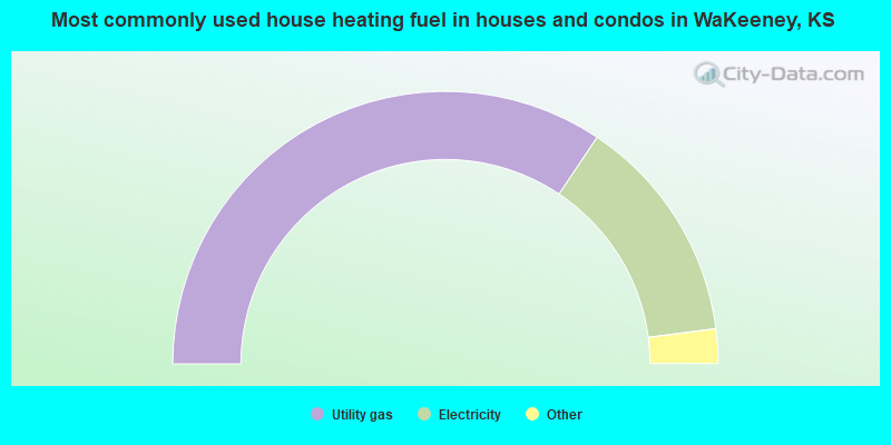
- 68.9%Utility gas
- 27.2%Electricity
- 3.0%No fuel used
- 0.9%Bottled, tank, or LP gas
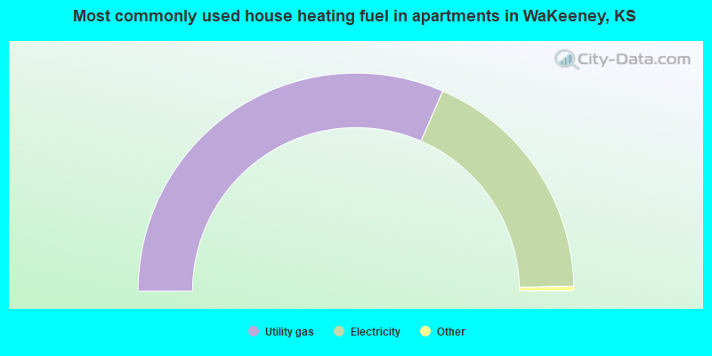
- 63.5%Utility gas
- 36.5%Electricity
WaKeeney compared to Kansas state average:
- Median house value below state average.
- Unemployed percentage significantly below state average.
- Black race population percentage significantly below state average.
- Hispanic race population percentage significantly below state average.
- Median age significantly above state average.
- Foreign-born population percentage significantly below state average.
- Length of stay since moving in significantly above state average.
- Number of college students below state average.
WaKeeney on our top lists:
- #65 on the list of "Top 100 high-educated but low-earning cities"
- #59 on the list of "Top 101 counties with the highest number of deaths per 1000 residents 2007-2013"