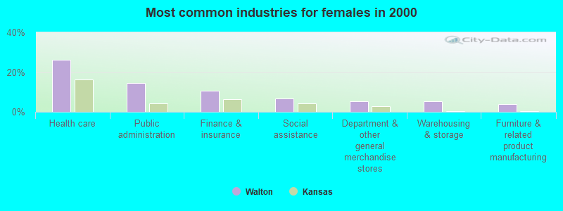
Other sales and related occupations, including supervisors (7.4%)
Metal workers and plastic workers (5.7%)
Other production occupations, including supervisors (5.1%)
Construction traders workers except carpenters, electricians, painters, plumbers, and construction laborers (4.5%)
Building and grounds cleaning and maintenance occupations (4.5%)
Information and record clerks, except customer service representatives (4.5%)
Bookkeeping, accounting, and auditing clerks (4.5%)
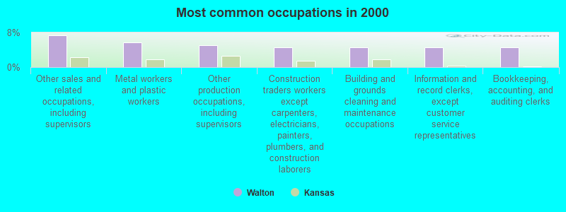
Metal workers and plastic workers (10.0%)
Construction traders workers except carpenters, electricians, painters, plumbers, and construction laborers (8.0%)
Assemblers and fabricators (7.0%)
Driver/sales workers and truck drivers (6.0%)
Other production occupations, including supervisors (6.0%)
Law enforcement workers, including supervisors (6.0%)
Farmers and farm managers (5.0%)
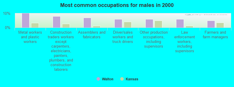
Other sales and related occupations, including supervisors (10.5%)
Bookkeeping, accounting, and auditing clerks (10.5%)
Child care workers (9.2%)
Information and record clerks, except customer service representatives (7.9%)
Building and grounds cleaning and maintenance occupations (6.6%)
Other office and administrative support workers, including supervisors (6.6%)
Registered nurses (5.3%)
Average climate in Walton, Kansas
Based on data reported by over 4,000 weather stations
Tornado activity:
Walton-area historical tornado activity is near Kansas state average. It is 93% greater than the overall U.S. average.
On 3/13/1990, a category F5 (max. wind speeds 261-318 mph) tornado 7.5 miles away from the Walton city center killed one personand injured 60 peopleand causedbetween $5,000,000 and $50,000,000 in damages.
On 3/13/1990, a category F5 tornado 9.7 miles away from the city center killed one personand causedbetween $5,000,000 and $50,000,000 in damages.
Earthquake activity:
Walton-area historical earthquake activity is significantly above Kansas state average. It is 756% greater than the overall U.S. average.
On 9/3/2016 at 12:02:44, a magnitude 5.8 (5.8 MW, Depth: 3.5 mi, Class: Moderate, Intensity: VI - VII) earthquake occurred 118.4 miles away from Walton center On 11/6/2011 at 03:53:10, a magnitude 5.7 (5.7 MW, Depth: 3.2 mi) earthquake occurred 180.9 miles away from Walton center On 11/12/2014 at 21:40:00, a magnitude 4.9 (4.9 MW, Depth: 2.5 mi, Class: Light, Intensity: IV - V) earthquake occurred 61.8 miles away from the city center On 2/13/2016 at 17:07:06, a magnitude 5.1 (5.1 MW, Depth: 5.2 mi) earthquake occurred 138.1 miles away from the city center On 1/19/2020 at 19:08:42, a magnitude 4.5 (4.5 MW, Depth: 3.1 mi) earthquake occurred 39.5 miles away from Walton center On 11/7/2016 at 01:44:24, a magnitude 5.0 (5.0 MW, Depth: 2.8 mi) earthquake occurred 149.2 miles away from Walton center Magnitude types: moment magnitude (MW)
Natural disasters:
The number of natural disasters in Harvey County (20) is greater than the US average (15). Major Disasters (Presidential) Declared: 14 Emergencies Declared: 3
Causes of natural disasters: Floods: 13, Storms: 11, Tornadoes: 7, Winds: 5, Winter Storms: 4, Explosion: 1, Heavy Rain: 1, Hurricane: 1, Landslide: 1, Mudslide: 1, Snow: 1, Snowstorm: 1, Other: 1 (Note: some incidents may be assigned to more than one category).
Hospitals and medical centers near Walton:
BETHEL HEALTH CARE CENTRE (Nursing Home, about 6 miles away; NORTH NEWTON, KS)
NEWTON PRESBYTERIAN MANOR (Nursing Home, about 6 miles away; NEWTON, KS)
KANSAS CHRISTIAN HOME (Nursing Home, about 7 miles away; NEWTON, KS)
AXTELL CHRISTIAN HOSPITAL (Hospital, about 7 miles away; NEWTON, KS)
NEWTON DIALYSIS CENTER (Dialysis Facility, about 8 miles away; NEWTON, KS)
RENAL CARE GROUP - NEWTON (Dialysis Facility, about 8 miles away; NEWTON, KS)
NEWTON MEDICAL CENTER Acute Care Hospitals (about 8 miles away; NEWTON, KS)
Amtrak station near Walton:
7 miles: NEWTON (5TH & MAIN STS.) . Services: ticket office, fully wheelchair accessible, enclosed waiting area, public restrooms, public payphones, vending machines, free short-term parking, free long-term parking, call for taxi service.
Colleges/universities with over 2000 students nearest to Walton:
Wichita Area Technical College (about 25 miles; Wichita, KS; Full-time enrollment: 2,220)
Wichita State University (about 28 miles; Wichita, KS; FT enrollment: 11,743)
Butler Community College (about 30 miles; El Dorado, KS; FT enrollment: 6,676)
Friends University (about 31 miles; Wichita, KS; FT enrollment: 2,024)
Newman University (about 32 miles; Wichita, KS; FT enrollment: 2,066)
Wichita Technical Institute (about 33 miles; Wichita, KS; FT enrollment: 2,015)
Hutchinson Community College (about 37 miles; Hutchinson, KS; FT enrollment: 4,174)
Public elementary/middle school in Walton:
WALTON RURAL LIFE CENTER (Location: 502 MAIN, Grades: PK-4, Charter school)
Library in Walton:
WALTON COMMUNITY LIBRARY (Operating income: $5,192; Location: 122 MAIN ST; 4,230 books; 25 e-books; 75 audio materials; 260 video materials; 30 state licensed databases; 55 print serial subscriptions)
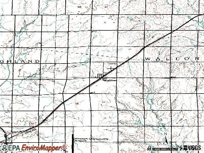
Notable locations in Walton: Team Marketing Alliance Grain Elevator Number 35 (A), Walton Police Department (B), Walton Fire Department (C), Walton Community Library (D). Display/hide their locations on the map
Harvey County has a predicted average indoor radon screening level between 2 and 4 pCi/L (pico curies per liter) - Moderate Potential
Drinking water stations with addresses in Walton that have no violations reported:
HARVEY CO RWD 1 (Population served: 3,000,Primary Water Source Type: Groundwater)
Average household size:
This city:
2.5 people
Kansas:
2.5 people
Percentage of family households:
This city:
74.2%
Whole state:
66.0%
Percentage of households with unmarried partners:
This city:
5.4%
Whole state:
5.8%
Likely homosexual households (counted as self-reported same-sex unmarried-partner households)
Lesbian couples: 1.1% of all households
Gay men: 0.0% of all households
Banks with branches in Walton (2011 data):
The Walton State Bank: at 116 Main St, branch established on 1907/05/27. Info updated 2010/09/29: Bank assets: $8.6 mil, Deposits: $8.0 mil, local headquarters, positive income, 1 total offices, Holding Company: J & M Bancshares, Inc.
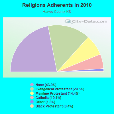
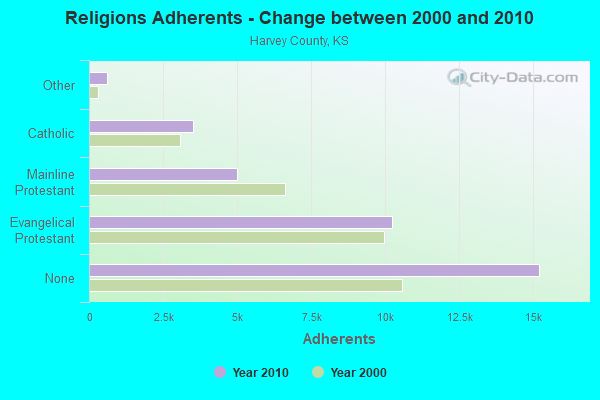
Religion statistics for Walton, KS (based on Harvey County data)
Religion
Adherents
Congregations
Evangelical Protestant
10,235
48
Mainline Protestant
5,000
20
Catholic
3,500
3
Other
611
2
Black Protestant
124
1
None
15,214
-
Source: Clifford Grammich, Kirk Hadaway, Richard Houseal, Dale E.Jones, Alexei Krindatch, Richie Stanley and Richard H.Taylor. 2012. 2010 U.S.Religion Census: Religious Congregations & Membership Study. Association of Statisticians of American Religious Bodies. Jones, Dale E., et al. 2002. Congregations and Membership in the United States 2000. Nashville, TN: Glenmary Research Center. Graphs represent county-level data
Corner Of First And Main (Lat: 38.118056 Lon: -97.518639), Call Sign: KNBM297, Assigned Frequencies: 154.355 MHz, Grant Date: 09/27/2011, Expiration Date: 09/27/2021, Cancellation Date: 11/27/2021, Registrant: City Of Walton, 122 Main St, Walton, KS 67151, Phone: (620) 837-3252, Email:
Eastside Of Town Walton Pit Rtu (Lat: 38.116667 Lon: -97.263083), Structure height: 3 m, Call Sign: WDC604, Assigned Frequencies: 173.237 MHz, Grant Date: 10/08/2022, Expiration Date: 11/30/2032, Registrant: Harvey County Rural Water District No 1, 210 Esau, Walton, KS 67151, Phone: (620) 837-5634, Fax: (620) 837-5641, Email:
Adjacent Santa Fe Right Of Way 1.65 Mi Sw (Lat: 38.097222 Lon: -97.278083), Type: Building, Structure height: 3 m, Overall height: 5 m, Call Sign: WPDY777, Assigned Frequencies: 160.935 MHz, Grant Date: 09/24/2013, Expiration Date: 12/22/2023, Cancellation Date: 03/29/2018, Registrant: Bnsf Railway Co., 4515 Kansas Ave, Kansas City, KS 66106, Phone: (913) 551-4015, Fax: (913) 551-4639, Email:
Call Sign: KB0NGH, Licensee ID: L00836987, Grant Date: 03/27/2014, Expiration Date: 06/22/2024, Certifier: Alan J Vermilyea, Registrant: Alan J Vermilyea, 9222 N Rock Rd, Walton, KS 67151-9034
Call Sign: N0OMO, Licensee ID: L00142132, Grant Date: 04/12/2021, Expiration Date: 07/02/2031, Certifier: Terry W Clover, Registrant: Terry W Clover, 314 N Walton Ave, Walton, KS 67151-8855
Call Sign: KD0VWD, Licensee ID: L01795610, Grant Date: 03/26/2024, Expiration Date: 03/26/2034, Certifier: Rex A Schechter, Registrant: Rex A Schechter, 5700 E Dutch Ave, Walton, KS 67151
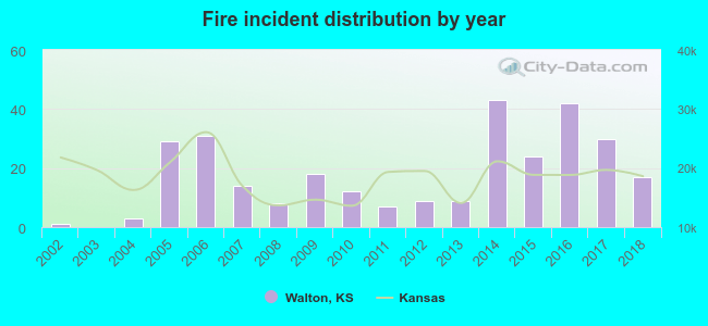
2002 - 2018 National Fire Incident Reporting System (NFIRS) incidents
According to the data from the years 2002 - 2018 the average number of fire incidents per year is 17. The highest number of fire incidents - 43 took place in 2014, and the least - 0 in 2003. The data has a rising trend.
When looking into fire subcategories, the most reports belonged to: Outside Fires (68.7%), and Structure Fires (20.2%).
Fire incident types reported to NFIRS in Walton, KS
 Recent articles from our blog. Our writers, many of them Ph.D. graduates or candidates, create easy-to-read articles on a wide variety of topics.


 According to the data from the years 2002 - 2018 the average number of fire incidents per year is 17. The highest number of fire incidents - 43 took place in 2014, and the least - 0 in 2003. The data has a rising trend.
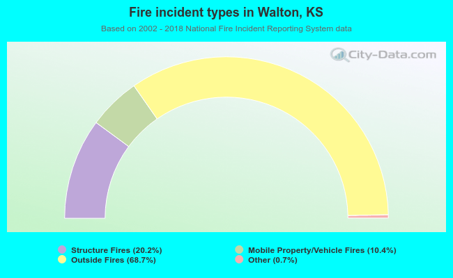 When looking into fire subcategories, the most reports belonged to: Outside Fires (68.7%), and Structure Fires (20.2%).