Weathersfield, Vermont
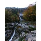
Weathersfield: Cascade Falls near Weathersfield, VT
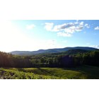
Weathersfield: This picture was taken by me during the summer of 2008. Springweather is my favorite place to go for walks. I have been going there since I was a small child.
Weathersfield: This picture was taken by me during the summer of 2008. Springweather is my favorite place to go for walks. I have been going there since I was a small child.
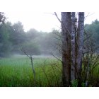
Weathersfield: I love Springweather! I have many many beautiful pictures I am having fun sharing some.
- add
your
Submit your own pictures of this town and show them to the world
- OSM Map
- Google Map
- MSN Map
Population change since 2000: +1.3%
 |
| Males: 1,441 | |
| Females: 1,384 |
| Median resident age: | 49.0 years |
| Vermont median age: | 45.8 years |
Zip codes: 05151.
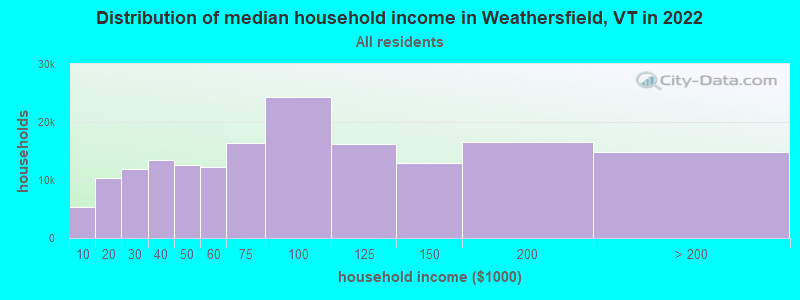
| Weathersfield: | $71,808 |
| VT: | $73,991 |
Estimated per capita income in 2022: $42,359 (it was $21,647 in 2000)
Weathersfield town income, earnings, and wages data
Estimated median house or condo value in 2022: $234,958 (it was $94,300 in 2000)
| Weathersfield: | $234,958 |
| VT: | $304,700 |
Mean prices in 2022: all housing units: $358,264; detached houses: $381,996; townhouses or other attached units: $340,107; in 2-unit structures: $283,645; in 3-to-4-unit structures: $498,076; in 5-or-more-unit structures: $190,965; mobile homes: $75,013
Detailed information about poverty and poor residents in Weathersfield, VT
Compare current foreclosures near Weathersfield, VT:
| Photo | Address | Area | Beds / Baths | Price | Details |
|---|---|---|---|---|---|

|
#1
Doe Hill Way
Woodstock, VT 05091
|
1,264 sq. feet
|
1 baths 1 beds |
$262,900
|
show details |

|
#2
S Main St
Newport, NH 03773
|
100 sq. feet
|
1 baths 1 beds |
$60,000
|
show details |

|
#3
S Koski Rd
Newport, NH 03773
|
1,596 sq. feet
|
2 baths 3 beds |
show details | |

|
#4
Elm St
Claremont, NH 03743
|
2,232 sq. feet
|
2 baths 4 beds |
show details | |

|
#5
Morways Park
Charlestown, NH 03603
|
1,064 sq. feet
|
2 baths 2 beds |
show details | |

|
#6
Old Springfield Rd
Charlestown, NH 03603
|
1,848 sq. feet
|
1 baths 4 beds |
show details | |

|
#7
Pine Grove St
Claremont, NH 03743
|
2,304 sq. feet
|
1 baths 3 beds |
show details | |

|
#8
Byrd Ave
Claremont, NH 03743
|
1,904 sq. feet
|
1 baths 3 beds |
show details | |

|
#9
Acworth Rd
Charlestown, NH 03603
|
1,826 sq. feet
|
1 baths 3 beds |
show details | |

|
#10
Elm St
Claremont, NH 03743
|
2,176 sq. feet
|
2 baths 5 beds |
show details |
| Photo | Address | Area | Beds / Baths | Price | Details |
|---|---|---|---|---|---|

|
#11
Taylor Hill Rd
Charlestown, NH 03603
|
2,226 sq. feet
|
2 baths 4 beds |
show details | |

|
#12
Dodge Pl
Claremont, NH 03743
|
1,650 sq. feet
|
2 baths 3 beds |
show details | |

|
#13
Blood Rd
Newport, NH 03773
|
- sq. feet
|
- baths - beds |
show details | |

|
#14
N Puckerbrush Rd
Reading, VT 05062
|
- sq. feet
|
- baths - beds |
show details | |

|
#15
Roberts Rd
Springfield, VT 05156
|
- sq. feet
|
- baths - beds |
show details | |

|
#16
Bavier Ave
Windsor, VT 05089
|
- sq. feet
|
- baths - beds |
show details | |

|
#17
W Pleasant St
Claremont, NH 03743
|
- sq. feet
|
- baths - beds |
show details | |

|
#18
W Terrace St
Claremont, NH 03743
|
- sq. feet
|
- baths - beds |
show details | |

|
#19
Westview Ter
Springfield, VT 05156
|
- sq. feet
|
- baths - beds |
show details | |

|
#20
Dogwood Ln
Springfield, VT 05156
|
- sq. feet
|
- baths - beds |
show details |
| Photo | Address | Area | Beds / Baths | Price | Details |
|---|---|---|---|---|---|

|
#21
Little Ascutney Rd
Perkinsville, VT 05151
|
- sq. feet
|
- baths - beds |
show details | |

|
#22
Edgebrook Park
Bellows Falls, VT 05101
|
- sq. feet
|
- baths - beds |
show details | |

|
#23
Upper Falls Rd
Perkinsville, VT 05151
|
- sq. feet
|
- baths - beds |
show details | |

|
#24
Mill St
Cavendish, VT 05142
|
- sq. feet
|
- baths - beds |
show details | |

|
#25
Mcdonough Rd
Newport, NH 03773
|
- sq. feet
|
- baths - beds |
show details | |

|
#26
Dillon Rd
Ludlow, VT 05149
|
- sq. feet
|
- baths - beds |
show details | |

|
#27
Taylor Dr
Springfield, VT 05156
|
- sq. feet
|
- baths - beds |
show details | |

|
#28
Parkview St
Newport, NH 03773
|
- sq. feet
|
- baths - beds |
show details | |

|
#29
Sawyer Hill Rd
Mount Holly, VT 05758
|
- sq. feet
|
- baths - beds |
show details | |

|
#30
Center St
North Walpole, NH 03609
|
- sq. feet
|
- baths - beds |
show details |
| Photo | Address | Area | Beds / Baths | Price | Details |
|---|---|---|---|---|---|

|
Check over 1 million property listings on Foreclosure.com!
|
browse all offers | |||
| Photo | Address | Area | Beds / Baths | Price | Details |
|---|

- 2,74297.1%White alone
- 321.1%Hispanic
- 291.0%Two or more races
- 120.4%Asian alone
- 40.1%Black alone
- 40.1%American Indian alone
- 20.07%Other race alone
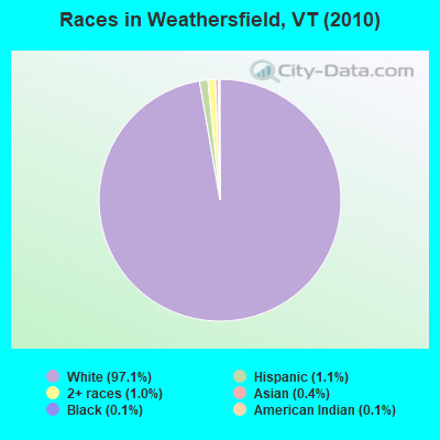
Races in Weathersfield detailed stats: ancestries, foreign born residents, place of birth
According to our research of Vermont and other state lists, there were 3 registered sex offenders living in Weathersfield, Vermont as of April 17, 2024.
The ratio of all residents to sex offenders in Weathersfield is 942 to 1.
The ratio of registered sex offenders to all residents in this city is lower than the state average.
Type |
2009 |
2010 |
2011 |
2012 |
2013 |
2014 |
2015 |
2016 |
2017 |
2018 |
2019 |
2020 |
2021 |
2022 |
|---|---|---|---|---|---|---|---|---|---|---|---|---|---|---|
| Murders (per 100,000) | 0 (0.0) | 0 (0.0) | 0 (0.0) | 0 (0.0) | 0 (0.0) | 0 (0.0) | 0 (0.0) | 0 (0.0) | 0 (0.0) | 0 (0.0) | 0 (0.0) | 0 (0.0) | 0 (0.0) | 0 (0.0) |
| Rapes (per 100,000) | 0 (0.0) | 0 (0.0) | 0 (0.0) | 0 (0.0) | 0 (0.0) | 0 (0.0) | 0 (0.0) | 0 (0.0) | 0 (0.0) | 1 (36.4) | 0 (0.0) | 0 (0.0) | 0 (0.0) | 6 (207.8) |
| Robberies (per 100,000) | 0 (0.0) | 0 (0.0) | 0 (0.0) | 0 (0.0) | 0 (0.0) | 0 (0.0) | 0 (0.0) | 0 (0.0) | 0 (0.0) | 0 (0.0) | 0 (0.0) | 0 (0.0) | 0 (0.0) | 0 (0.0) |
| Assaults (per 100,000) | 0 (0.0) | 0 (0.0) | 0 (0.0) | 0 (0.0) | 1 (35.6) | 1 (35.9) | 0 (0.0) | 1 (36.2) | 0 (0.0) | 3 (109.3) | 2 (72.6) | 1 (36.7) | 0 (0.0) | 2 (69.3) |
| Burglaries (per 100,000) | 10 (352.6) | 9 (318.6) | 6 (212.2) | 14 (496.1) | 16 (570.2) | 10 (358.8) | 7 (251.4) | 6 (217.0) | 9 (325.3) | 4 (145.7) | 3 (109.0) | 3 (110.0) | 5 (184.0) | 0 (0.0) |
| Thefts (per 100,000) | 16 (564.2) | 23 (814.2) | 14 (495.0) | 9 (318.9) | 29 (1,033) | 34 (1,220) | 12 (431.0) | 11 (397.8) | 6 (216.8) | 11 (400.7) | 3 (109.0) | 5 (183.4) | 25 (919.8) | 8 (277.1) |
| Auto thefts (per 100,000) | 1 (35.3) | 0 (0.0) | 1 (35.4) | 2 (70.9) | 2 (71.3) | 1 (35.9) | 0 (0.0) | 0 (0.0) | 1 (36.1) | 0 (0.0) | 1 (36.3) | 1 (36.7) | 1 (36.8) | 2 (69.3) |
| Arson (per 100,000) | 0 (0.0) | 0 (0.0) | 0 (0.0) | 0 (0.0) | 0 (0.0) | 0 (0.0) | 1 (35.9) | 0 (0.0) | 0 (0.0) | 0 (0.0) | 0 (0.0) | 0 (0.0) | 0 (0.0) | 0 (0.0) |
| City-Data.com crime index | 50.1 | 54.9 | 37.5 | 53.2 | 94.1 | 84.0 | 34.8 | 38.3 | 34.3 | 77.2 | 29.4 | 25.3 | 52.6 | 196.7 |
The City-Data.com crime index weighs serious crimes and violent crimes more heavily. Higher means more crime, U.S. average is 246.1. It adjusts for the number of visitors and daily workers commuting into cities.
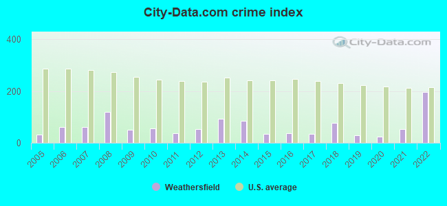
Crime rate in Weathersfield detailed stats: murders, rapes, robberies, assaults, burglaries, thefts, arson
Full-time law enforcement employees in 2021, including police officers: 2 (2 officers - 2 male; 0 female).
| Officers per 1,000 residents here: | 0.74 |
| Vermont average: | 1.69 |
 Recent articles from our blog. Our writers, many of them Ph.D. graduates or candidates, create easy-to-read articles on a wide variety of topics.
Ancestries: English (21.1%), French (15.1%), Irish (12.2%), United States (9.5%), French Canadian (9.0%), German (6.5%).
Current Local Time: EST time zone
Land area: 43.8 square miles.
Population density: 65 people per square mile (very low).
57 residents are foreign born (1.1% Europe, 0.5% North America, 0.3% Asia).
| This town: | 2.0% |
| Vermont: | 3.8% |
| Weathersfield town: | 2.1% ($1,934) |
| Vermont: | 2.0% ($2,196) |
Nearest city with pop. 50,000+: Manchester, NH  (57.9 miles , pop. 107,006).
Nearest city with pop. 200,000+: Boston, MA (101.3 miles , pop. 589,141).
Nearest city with pop. 1,000,000+: Bronx, NY (189.9 miles , pop. 1,332,650).
Nearest cities:
), ), )Latitude: 43.38 N, Longitude: 72.46 W
Area code: 802
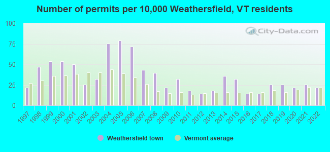
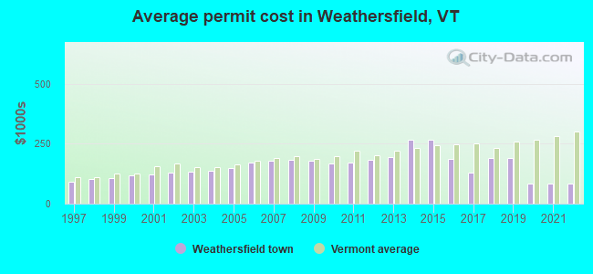
Single-family new house construction building permits:
- 2022: 6 buildings, average cost: $83,600
- 2021: 7 buildings, average cost: $81,600
- 2020: 6 buildings, average cost: $81,600
- 2019: 7 buildings, average cost: $190,700
- 2018: 7 buildings, average cost: $190,700
- 2017: 4 buildings, average cost: $130,000
- 2016: 4 buildings, average cost: $187,500
- 2015: 9 buildings, average cost: $268,000
- 2014: 10 buildings, average cost: $268,000
- 2013: 5 buildings, average cost: $193,300
- 2012: 4 buildings, average cost: $184,000
- 2011: 5 buildings, average cost: $172,800
- 2010: 9 buildings, average cost: $165,900
- 2009: 6 buildings, average cost: $178,900
- 2008: 11 buildings, average cost: $182,400
- 2007: 12 buildings, average cost: $181,200
- 2006: 20 buildings, average cost: $171,000
- 2005: 22 buildings, average cost: $150,200
- 2004: 21 buildings, average cost: $138,500
- 2003: 9 buildings, average cost: $132,300
- 2002: 7 buildings, average cost: $130,700
- 2001: 14 buildings, average cost: $121,400
- 2000: 15 buildings, average cost: $116,800
- 1999: 15 buildings, average cost: $108,200
- 1998: 13 buildings, average cost: $101,700
- 1997: 6 buildings, average cost: $91,700
| Here: | 1.9% |
| Vermont: | 2.0% |
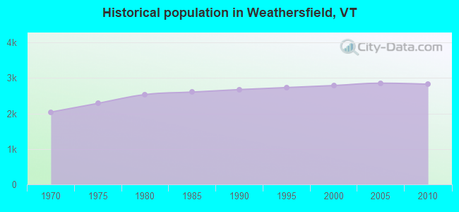
Population change in the 1990s: +88 (+3.3%).

- Health care (11.6%)
- Construction (11.2%)
- Educational services (10.5%)
- Machinery (6.4%)
- Accommodation & food services (5.4%)
- Professional, scientific, technical services (3.9%)
- Food & beverage stores (3.3%)
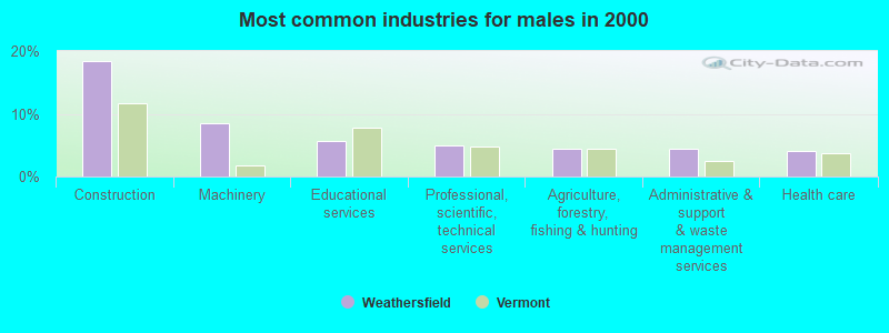
- Construction (18.5%)
- Machinery (8.5%)
- Educational services (5.6%)
- Professional, scientific, technical services (5.0%)
- Agriculture, forestry, fishing & hunting (4.5%)
- Administrative & support & waste management services (4.5%)
- Health care (4.1%)
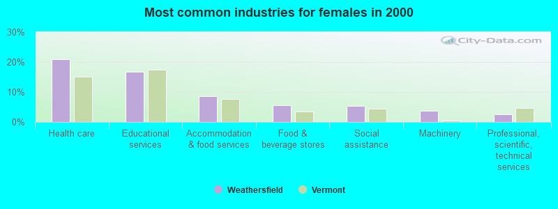
- Health care (21.0%)
- Educational services (16.7%)
- Accommodation & food services (8.6%)
- Food & beverage stores (5.6%)
- Social assistance (5.4%)
- Machinery (3.7%)
- Professional, scientific, technical services (2.5%)
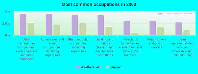
- Other management occupations, except farmers and farm managers (4.5%)
- Other sales and related occupations, including supervisors (4.5%)
- Other production occupations, including supervisors (4.4%)
- Building and grounds cleaning and maintenance occupations (4.2%)
- Preschool, kindergarten, elementary, and middle school teachers (3.0%)
- Metal workers and plastic workers (3.0%)
- Sales representatives, services, wholesale and manufacturing (2.8%)
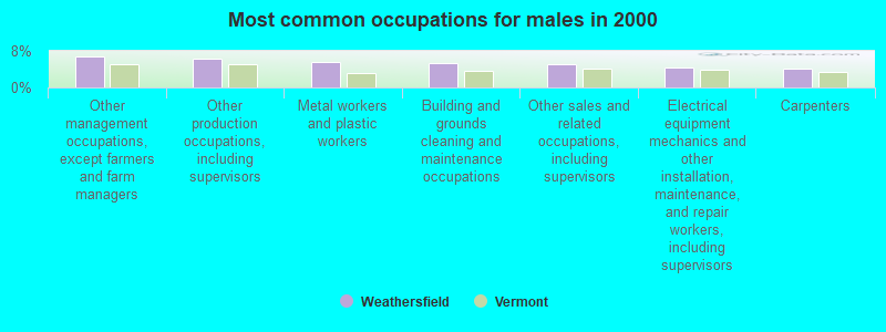
- Other management occupations, except farmers and farm managers (6.9%)
- Other production occupations, including supervisors (6.2%)
- Metal workers and plastic workers (5.5%)
- Building and grounds cleaning and maintenance occupations (5.2%)
- Other sales and related occupations, including supervisors (5.1%)
- Electrical equipment mechanics and other installation, maintenance, and repair workers, including supervisors (4.3%)
- Carpenters (4.1%)
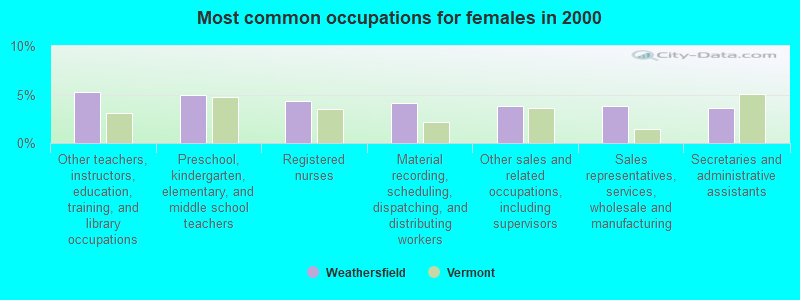
- Other teachers, instructors, education, training, and library occupations (5.2%)
- Preschool, kindergarten, elementary, and middle school teachers (4.9%)
- Registered nurses (4.3%)
- Material recording, scheduling, dispatching, and distributing workers (4.1%)
- Other sales and related occupations, including supervisors (3.8%)
- Sales representatives, services, wholesale and manufacturing (3.8%)
- Secretaries and administrative assistants (3.7%)
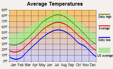
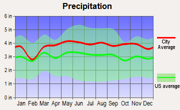
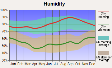
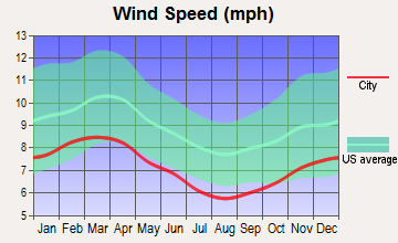
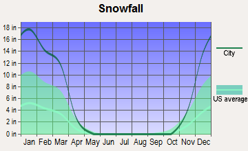
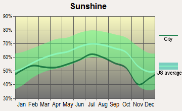
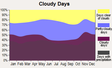
Average climate in Weathersfield, Vermont
Based on data reported by over 4,000 weather stations
(lower is better)
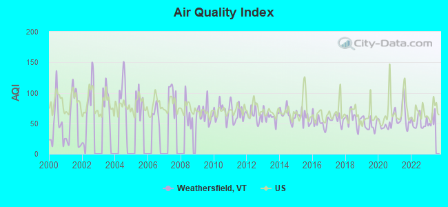
Air Quality Index (AQI) level in 2022 was 51.4. This is significantly better than average.
| City: | 51.4 |
| U.S.: | 72.6 |
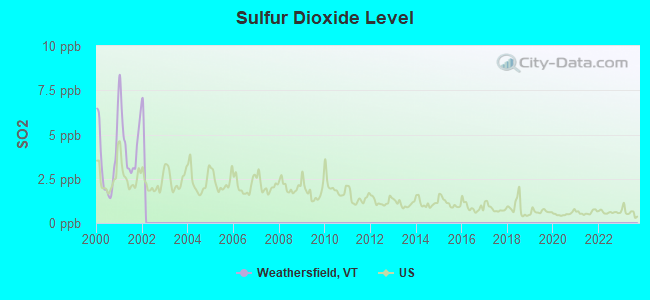
Sulfur Dioxide (SO2) [ppb] level in 2001 was 4.62. This is significantly worse than average. Closest monitor was 6.3 miles away from the city center.
| City: | 4.62 |
| U.S.: | 1.51 |
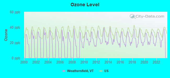
Ozone [ppb] level in 2022 was 25.3. This is better than average. Closest monitor was 6.4 miles away from the city center.
| City: | 25.3 |
| U.S.: | 33.3 |
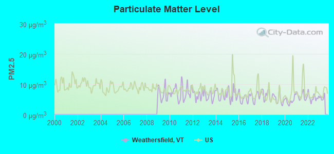
Particulate Matter (PM2.5) [µg/m3] level in 2022 was 5.54. This is significantly better than average. Closest monitor was 6.4 miles away from the city center.
| City: | 5.54 |
| U.S.: | 8.11 |
Tornado activity:
Weathersfield-area historical tornado activity is above Vermont state average. It is 53% smaller than the overall U.S. average.
On 8/20/1968, a category F3 (max. wind speeds 158-206 mph) tornado 26.0 miles away from the Weathersfield town center injured one person and caused between $5000 and $50,000 in damages.
On 7/9/1962, a category F2 (max. wind speeds 113-157 mph) tornado 1.1 miles away from the town center caused between $5000 and $50,000 in damages.
Earthquake activity:
Weathersfield-area historical earthquake activity is significantly above Vermont state average. It is 70% smaller than the overall U.S. average.On 4/20/2002 at 10:50:47, a magnitude 5.3 (5.3 ML, Depth: 3.0 mi, Class: Moderate, Intensity: VI - VII) earthquake occurred 99.3 miles away from the city center
On 10/7/1983 at 10:18:46, a magnitude 5.3 (5.1 MB, 5.3 LG, 5.1 ML) earthquake occurred 101.9 miles away from the city center
On 4/20/2002 at 10:50:47, a magnitude 5.2 (5.2 MB, 4.2 MS, 5.2 MW, 5.0 MW) earthquake occurred 98.6 miles away from Weathersfield center
On 1/19/1982 at 00:14:42, a magnitude 4.7 (4.5 MB, 4.7 MD, 4.5 LG, Class: Light, Intensity: IV - V) earthquake occurred 44.0 miles away from Weathersfield center
On 10/16/2012 at 23:12:25, a magnitude 4.7 (4.7 ML, Depth: 10.0 mi) earthquake occurred 91.8 miles away from the city center
On 6/17/1991 at 08:53:16, a magnitude 4.1 (4.0 MB, 4.0 LG, Depth: 3.1 mi) earthquake occurred 123.6 miles away from Weathersfield center
Magnitude types: regional Lg-wave magnitude (LG), body-wave magnitude (MB), duration magnitude (MD), local magnitude (ML), surface-wave magnitude (MS), moment magnitude (MW)
Natural disasters:
The number of natural disasters in Windsor County (20) is greater than the US average (15).Major Disasters (Presidential) Declared: 16
Emergencies Declared: 2
Causes of natural disasters: Floods: 14, Storms: 13, Tropical Storms: 2, Heavy Rain: 1, Hurricane: 1, Ice Storm: 1, Landslide: 1, Snowstorm: 1, Wind: 1, Winter Storm: 1 (Note: some incidents may be assigned to more than one category).
Hospitals and medical centers near Weathersfield:
- CEDAR HILL HEALTH CARE CENTER (Nursing Home, about 5 miles away; WINDSOR, VT)
- VALLEY REGIONAL HOSPITAL Critical Access Hospitals (about 7 miles away; CLAREMONT, NH)
- SPRINGFIELD HEALTH AND REHAB (Nursing Home, about 7 miles away; SPRINGFIELD, VT)
- ELM WOOD CENTER AT CLAREMONT (Nursing Home, about 7 miles away; CLAREMONT, NH)
- MT ASCUTNEY HOSPITAL Critical Access Hospitals (about 9 miles away; WINDSOR, VT)
- GILL ODD FELLOWS HOME (Nursing Home, about 12 miles away; LUDLOW, VT)
- CONNECTICUT VALLEY HOME CARE (Home Health Center, about 13 miles away; NEWPORT, NH)
Amtrak stations near Weathersfield:
- 5 miles: CLAREMONT (PLAINS RD.) . Services: public payphones, free short-term parking, free long-term parking.
- 8 miles: WINDSOR-MOUNT ASCUTNEY (WINDSOR, DEPOT AVE.) . Services: public payphones, free short-term parking, free long-term parking, call for car rental service, intercity bus service.
- 13 miles: OKEMO (LUDLOW, OKEMO MOUNTAIN) - Seasonal Bus Station
Colleges/universities with over 2000 students nearest to Weathersfield:
- Dartmouth College (about 24 miles; Hanover, NH; Full-time enrollment: 6,030)
- Keene State College (about 33 miles; Keene, NH; FT enrollment: 5,098)
- Castleton State College (about 40 miles; Castleton, VT; FT enrollment: 2,079)
- Franklin Pierce University (about 47 miles; Rindge, NH; FT enrollment: 2,139)
- Plymouth State University (about 47 miles; Plymouth, NH; FT enrollment: 4,838)
- NHTI-Concord's Community College (about 49 miles; Concord, NH; FT enrollment: 2,865)
- Norwich University (about 54 miles; Northfield, VT; FT enrollment: 4,221)
Points of interest:
Notable locations in Weathersfield: Crown Point Country Club (A), Crown Point Camping Area (B), Running Bear Campground (C), Weathersfield Center (D), Ascutney Volunteer Fire Department (E), West Weathersfield Volunteer Fire Department (F). Display/hide their locations on the map
Churches in Weathersfield include: Bow Church (A), Perkinsville Community Church (B). Display/hide their locations on the map
Cemeteries: Plain Cemetery (1), Weathersfield Bow Cemetery (2), Upham-Aldrich Cemetery (3), Tuttle Cemetery (4), Toles Cemetery (5), Hubbard Cemetery (6), Grout Cemetery (7). Display/hide their locations on the map
Lakes and reservoirs: Cooks Pond (A), Stoughton Pond (B), Quarry Pond (C), Springfield Reservoir (D), North Springfield Reservoir (E). Display/hide their locations on the map
River: North Branch Black River (A). Display/hide its location on the map
Parks in Weathersfield include: Wilgus State Park (1), North Springfield Lake Recreation Area (2), Weathersfield Center Historic District (3), Little Ascutney State Wildlife Manage Area (4). Display/hide their locations on the map
Birthplace of: Edgar J. Sherman - Politician, Aretas Blood - (1816-1897), railroad steam locomotive builder.
| This town: | 2.2 people |
| Vermont: | 2.3 people |
| This town: | 67.1% |
| Whole state: | 62.5% |
| This town: | 8.6% |
| Whole state: | 9.2% |
Likely homosexual households (counted as self-reported same-sex unmarried-partner households)
- Lesbian couples: 0.4% of all households
- Gay men: 0.6% of all households
| This town: | 6.5% |
| Whole state: | 9.4% |
| This town: | 3.8% |
| Whole state: | 3.6% |
For population 15 years and over in Weathersfield:
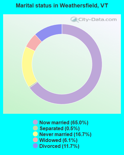
- Never married: 16.7%
- Now married: 65.0%
- Separated: 0.5%
- Widowed: 6.1%
- Divorced: 11.7%
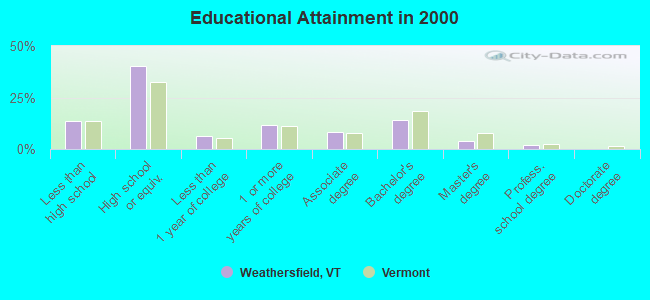
For population 25 years and over in Weathersfield:
- High school or higher: 86.2%
- Bachelor's degree or higher: 19.8%
- Graduate or professional degree: 5.8%
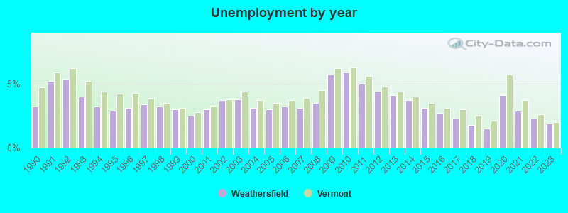
- Unemployed: 3.3%
- Mean travel time to work (commute): 23.4 minutes
| Here: | 10.4 |
| Vermont average: | 11.7 |
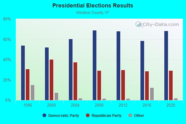
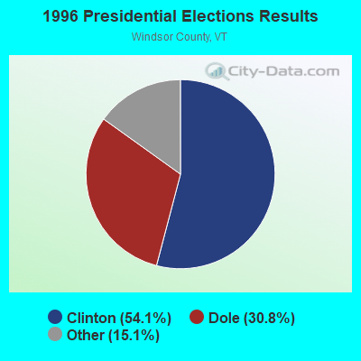
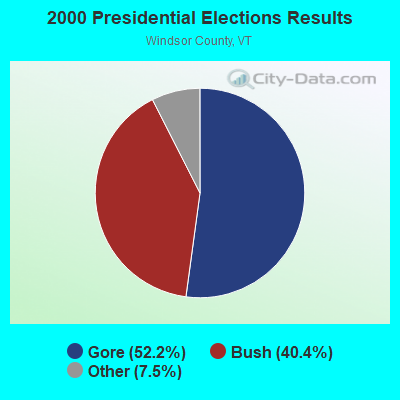
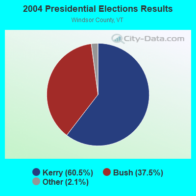
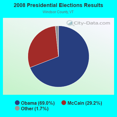
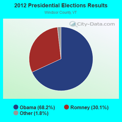
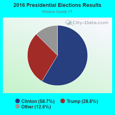
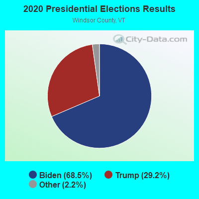
Graphs represent county-level data. Detailed 2008 Election Results
Religion statistics for Weathersfield, VT (based on Windsor County data)
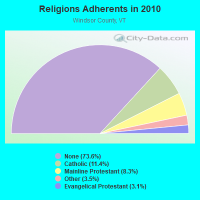
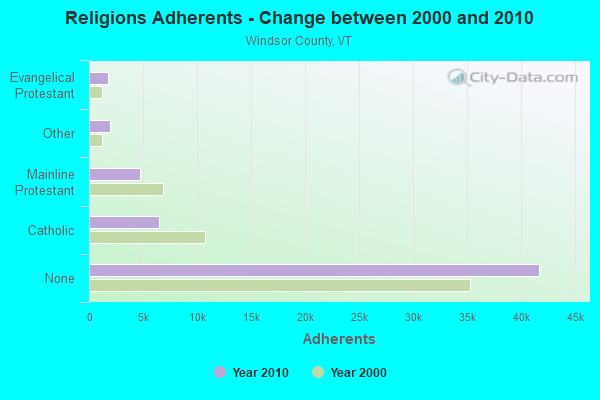
| Religion | Adherents | Congregations |
|---|---|---|
| Catholic | 6,485 | 10 |
| Mainline Protestant | 4,700 | 45 |
| Other | 1,964 | 17 |
| Evangelical Protestant | 1,750 | 21 |
| Orthodox | 55 | 1 |
| None | 41,716 | - |
Food Environment Statistics:
| Here: | 4.93 / 10,000 pop. |
| Vermont: | 3.84 / 10,000 pop. |
| This county: | 1.23 / 10,000 pop. |
| Vermont: | 1.95 / 10,000 pop. |
| Here: | 7.93 / 10,000 pop. |
| Vermont: | 6.40 / 10,000 pop. |
| Windsor County: | 14.97 / 10,000 pop. |
| Vermont: | 11.52 / 10,000 pop. |
| Windsor County: | 7.1% |
| Vermont: | 6.8% |
| Windsor County: | 22.8% |
| Vermont: | 22.3% |
| Here: | 9.7% |
| State: | 13.3% |
Strongest AM radio stations in Weathersfield:
- WNBX (1480 AM; 5 kW; SPRINGFIELD, VT)
- WNTK (1020 AM; 10 kW; NEWPORT, NH; Owner: KOOR COMMUNICATIONS, INC.)
- WTSV (1230 AM; 1 kW; CLAREMONT, NH; Owner: GREAT NORTHERN RADIO, L.L.C.)
- WNNZ (640 AM; 50 kW; WESTFIELD, MA; Owner: CLEAR CHANNEL BROADCASTING LICENSES, INC.)
- WRKO (680 AM; 50 kW; BOSTON, MA; Owner: ENTERCOM BOSTON LICENSE, LLC)
- WCRN (830 AM; 50 kW; WORCESTER, MA; Owner: CARTER BROADCASTING CORPORATION)
- WGY (810 AM; 50 kW; SCHENECTADY, NY; Owner: CLEAR CHANNEL BROADCASTING LICENSES, INC.)
- WEEI (850 AM; 50 kW; BOSTON, MA; Owner: ENTERCOM BOSTON LICENSE, LLC)
- WKOX (1200 AM; 50 kW; FRAMINGHAM, MA; Owner: CAPSTAR TX LIMITED PARTNERSHIP)
- WVNE (760 AM; daytime; 25 kW; LEICESTER, MA; Owner: BLOUNT MASSCOM, INC.)
- WPTR (1540 AM; 50 kW; ALBANY, NY; Owner: KIMTRON, INC.)
- WBIX (1060 AM; 40 kW; NATICK, MA; Owner: LANGER BROADCASTING CORPORATION)
- WALE (990 AM; 50 kW; GREENVILLE, RI; Owner: NORTH AMERICAN BROADCASTING CO., INC.)
Strongest FM radio stations in Weathersfield:
- WVPR (89.5 FM; WINDSOR, VT; Owner: VERMONT PUBLIC RADIO)
- WHDQ (106.1 FM; CLAREMONT, NH; Owner: GREAT NORTHERN RADIO, L.L.C.)
- WVRR (101.7 FM; NEWPORT, NH; Owner: CAPSTAR TX LIMITED PARTNERSHIP)
- WXKK (93.5 FM; SPRINGFIELD, VT; Owner: CLEAR CHANNEL BROADCASTING LICENSES, INC.)
- WJJR (98.1 FM; RUTLAND, VT; Owner: 6 JOHNSON ROAD LICENSES, INC.)
- WZRT (97.1 FM; RUTLAND, VT; Owner: CAPSTAR TX LIMITED PARTNERSHIP)
- WEBK (105.3 FM; KILLINGTON, VT; Owner: 6 JOHNSON ROAD LICENSES, INC.)
- WGLV (91.7 FM; WOODSTOCK, VT; Owner: CHRISTIAN MINISTRIES INC)
- WHDQ-FM1 (106.1 FM; RUTLAND, VT; Owner: GREAT NORTHERN RADIO, L.L.C.)
- WEQX (102.7 FM; MANCHESTER, VT; Owner: NORTHSHIRE COMMUNICATIONS, INC.)
- WJAN (95.1 FM; SUNDERLAND, VT; Owner: 6 JOHNSON ROAD LICENSES, INC.)
- WMXR (93.9 FM; WOODSTOCK, VT; Owner: CLEAR CHANNEL BROADCASTING LICENSES, INC.)
- WZSH (107.1 FM; BELLOWS FALLS, VT; Owner: GREAT NORTHERN RADIO, L.L.C.)
- WEVH (91.3 FM; HANOVER, NH; Owner: NEW HAMPSHIRE PUBLIC RADIO INC)
- WKNE (103.7 FM; KEENE, NH; Owner: SAGA COMMUNICATIONS OF NEW ENGLAND, LLC)
- WEVN (90.7 FM; KEENE, NH; Owner: NEW HAMPSHIRE PUBLIC RADIO, INC.)
- WXXK (100.5 FM; LEBANON, NH; Owner: CAPSTAR TX LIMITED PARTNERSHIP)
- WVAY (100.7 FM; WILMINGTON, VT; Owner: GREAT NORTHERN RADIO, L.L.C.)
- WNTK-FM (99.7 FM; NEW LONDON, NH; Owner: SHEILA E. VINIKOOR)
- WJEN (94.5 FM; RUTLAND, VT; Owner: 6 JOHNSON ROAD LICENSES, INC.)
TV broadcast stations around Weathersfield:
- WVTA (Channel 41; WINDSOR, VT; Owner: VERMONT ETV, INC.)
- W17CI (Channel 17; CLAREMONT, NH; Owner: UPPER VALLEY BROADCASTING, LLC)
- WNNE (Channel 31; HARTFORD, VT; Owner: HEARST-ARGYLE STATIONS, INC.)
- WEKW-TV (Channel 52; KEENE, NH; Owner: UNIVERSITY OF NEW HAMPSHIRE)
- W62AT (Channel 62; BELLOWS FALLS, VT; Owner: MT. MANSFIELD TELEVISION, INC.)
- W15BK (Channel 15; HANOVER, NH; Owner: UNIVERSITY OF NEW HAMPSHIRE)
- W10AC (Channel 10; CLAREMONT, NH; Owner: CLAREMONT TELEVISION, INC.)
- W12AF (Channel 12; CLAREMONT, NH; Owner: CLAREMONT TELEVISION INC.)
- National Bridge Inventory (NBI) Statistics
- 20Number of bridges
- 226ft / 69.2mTotal length
- $13,688,000Total costs
- 103,598Total average daily traffic
- 11,196Total average daily truck traffic
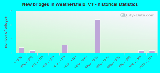
- New bridges - historical statistics
- 2Before 1900
- 11900-1909
- 31930-1939
- 121960-1969
- 12000-2009
- 12010-2019
FCC Registered Antenna Towers:
4- Aiko Sogabe, 7228 Vermont Route 131 (281630) (Lat: 43.398389 Lon: -72.512500), Type: 44.2, Structure height: 50027 m, Overall height: 36.6 m, Registrant: American Towers LLC, Faa-Fcc@americantower.Com, , Wobur-n, Phone: (781) 926-4500
- Aiko Sogabe, 7228 Vermont Route 131 (281630) (Lat: 43.398389 Lon: -72.512500), Type: 44.2, Structure height: 50027 m, Overall height: 36.6 m, Registrant: American Towers LLC, Faa-Fcc@americantower.Com, , Wobur-n, Phone: (781) 926-4500
- Aiko Sogabe, 7228 Vermont Rt 131 (281630) (Lat: 43.398389 Lon: -72.512500), Type: 44.2, Structure height: 50027 m, Overall height: 36.6 m, Registrant: American Towers LLC, Faa-Fcc@americantower.Com, , Wobur-n, Phone: (781) 926-4500
- Aiko Sogabe, 7228 Vermont Rt 131 (281630) (Lat: 43.398389 Lon: -72.512500), Type: 44.2, Structure height: 50027 m, Overall height: 36.6 m, Licensee ID: L, Registrant: American Towers LLC, Faa-Fcc@americantower.Com, , Wobur-n, Phone: (781) 926-4500
FCC Registered Broadcast Land Mobile Towers:
1- Perkinsville Fire Station (Lat: 43.401194 Lon: -72.513417), Call Sign: KNDJ507,
Assigned Frequencies: 46.0800 MHz, Grant Date: 06/05/1997, Expiration Date: 08/06/2002, Cancellation Date: 12/08/2002, Registrant: Weathersfield, Town Of, West Weatherfield Fire Station, Perkinsville, VT 05151, Phone: (802) 263-5309
FCC Registered Microwave Towers:
2- ASCUTNEY FAC, 4402 Route 5 (Lat: 43.395278 Lon: -72.407500), Type: Mtower, Structure height: 18.3 m, Overall height: 19.3 m, Call Sign: WQTG245,
Assigned Frequencies: 11545.0 MHz, 11545.0 MHz, 11545.0 MHz, Grant Date: 01/27/2014, Expiration Date: 01/27/2024, Cancellation Date: 03/30/2024, Certifier: Philip T Chitwood, Registrant: Vermont Transco, LLC, 366 Pinnacle Ridge Rd, Rutland, VT 05701, Phone: (802) 772-3777, Email:
- STATION, Ascutney Substa (Lat: 43.400889 Lon: -72.419250), Overall height: 19.2 m, Call Sign: WAY493,
Assigned Frequencies: 1975.00 MHz, Grant Date: 10/26/1995, Expiration Date: 10/26/2000, Cancellation Date: 01/28/2001, Phone: (802) 773-9161
FCC Registered Amateur Radio Licenses:
2- Call Sign: KA2MSM, Licensee ID: L01498477, Grant Date: 06/13/2009, Expiration Date: 08/05/2019, Cancellation Date: 08/06/2021, Registrant: Mark A Kernagis, 955 Plains Road, Weathersfield, VT 05151
- Call Sign: KA2QMP, Licensee ID: L01498484, Grant Date: 06/13/2009, Expiration Date: 06/13/2019, Cancellation Date: 06/15/2021, Registrant: Bonnie L Kernagis, 955 Plains Road, Weathersfield, VT 05151
FAA Registered Aircraft:
1- Aircraft: SIX CHUTER WEST LLC LEGEND XL (Category: Land, Seats: 2, Weight: Up to 12,499 Pounds), Engine: ROTAX 912UL SERIES (80 HP) (4 Cycle)
N-Number: 105SC, N105SC, N-105SC, Serial Number: 3145, Year manufactured: 2014, Airworthiness Date: 08/22/2014, Certificate Issue Date: 03/21/2017
Registrant (Individual): Christopher J Davey, 1325 Skyline Dr, Weathersfield, VT 05156
2003 - 2018 National Fire Incident Reporting System (NFIRS) incidents
- Fire incident types reported to NFIRS in Weathersfield, VT
- 8663.2%Structure Fires
- 4432.4%Outside Fires
- 53.7%Mobile Property/Vehicle Fires
- 10.7%Other
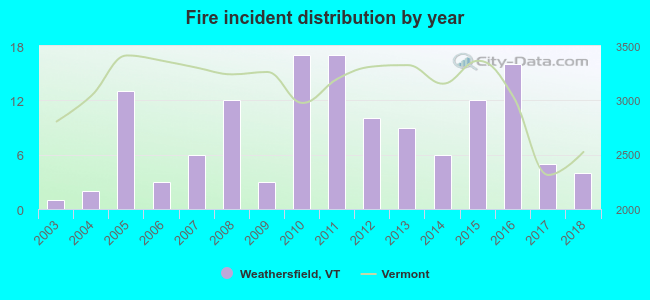 According to the data from the years 2003 - 2018 the average number of fire incidents per year is 8. The highest number of reported fires - 17 took place in 2010, and the least - 1 in 2003. The data has a growing trend.
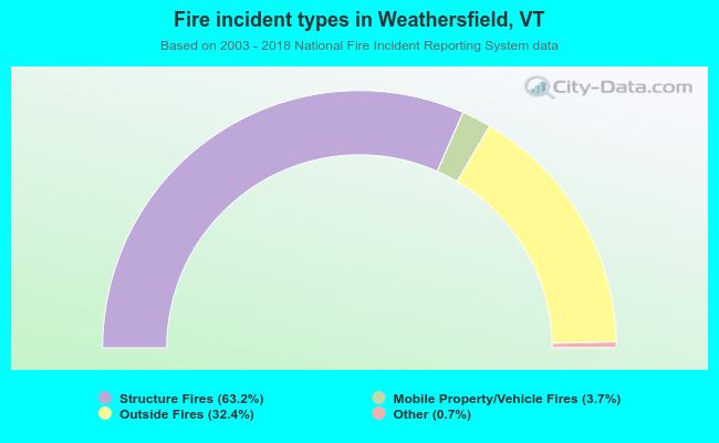 When looking into fire subcategories, the most incidents belonged to: Structure Fires (63.2%), and Outside Fires (32.4%).
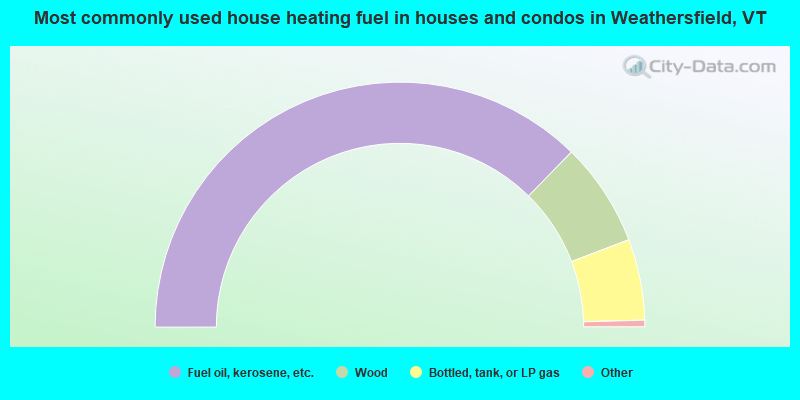
- 74.7%Fuel oil, kerosene, etc.
- 13.7%Wood
- 10.7%Bottled, tank, or LP gas
- 0.5%Utility gas
- 0.4%Electricity
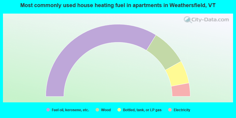
- 67.7%Fuel oil, kerosene, etc.
- 16.2%Wood
- 10.2%Bottled, tank, or LP gas
- 6.0%Electricity
Weathersfield compared to Vermont state average:
- Unemployed percentage significantly below state average.
- Black race population percentage significantly below state average.
- Hispanic race population percentage below state average.
- Foreign-born population percentage below state average.
- Renting percentage significantly below state average.
- Length of stay since moving in significantly above state average.
- Number of rooms per house significantly below state average.
- House age significantly below state average.
- Percentage of population with a bachelor's degree or higher below state average.
State forum archive: