Weogufka-Marble Valley, Alabama
Submit your own pictures of this place and show them to the world
- OSM Map
- Google Map
- MSN Map
| Males: 1,908 | |
| Females: 1,863 |
| Median resident age: | 38.2 years |
| Alabama median age: | 35.8 years |
Zip code: 35183
| Weogufka-Marble Valley: | $54,608 |
| AL: | $59,674 |
Estimated per capita income in 2022: $31,612 (it was $16,008 in 2000)
Weogufka-Marble Valley CCD income, earnings, and wages data
Estimated median house or condo value in 2022: $131,595 (it was $57,200 in 2000)
| Weogufka-Marble Valley: | $131,595 |
| AL: | $200,900 |
Mean prices in 2022: all housing units: $166,797; detached houses: $210,568; mobile homes: $69,306
Weogufka-Marble Valley, AL residents, houses, and apartments details
Detailed information about poverty and poor residents in Weogufka-Marble Valley, AL
Compare current foreclosures near your location:
| Photo | Address | Area | Beds / Baths | Price | Details |
|---|---|---|---|---|---|

|
#1
S High St
Columbus, OH 43207
|
1,678 sq. feet
|
2 baths 4 beds |
$31,900
|
show details |

|
#2
Bayberry Cir
Columbus, OH 43207
|
1,564 sq. feet
|
1 baths 3 beds |
$127,500
|
show details |

|
#3
E 21st Ave
Columbus, OH 43211
|
1,061 sq. feet
|
1 baths 3 beds |
$187,900
|
show details |

|
#4
Meadowbrook Dr
Columbus, OH 43207
|
1,752 sq. feet
|
2 baths 4 beds |
show details | |

|
#5
Bretton Pl
Columbus, OH 43211
|
1,056 sq. feet
|
1 baths 3 beds |
show details | |

|
#6
S Richardson Ave
Columbus, OH 43204
|
1,520 sq. feet
|
2 baths 3 beds |
show details | |

|
#7
Fergus Rd
Grove City, OH 43123
|
3,312 sq. feet
|
2 baths 4 beds |
show details | |

|
#8
High Free Pike
West Jefferson, OH 43162
|
1,216 sq. feet
|
2 baths 4 beds |
show details | |

|
#9
S Chillicothe St
Plain City, OH 43064
|
1,736 sq. feet
|
2 baths 4 beds |
show details | |

|
#10
Kingsglen Dr
Grove City, OH 43123
|
1,635 sq. feet
|
2 baths 4 beds |
show details |
| Photo | Address | Area | Beds / Baths | Price | Details |
|---|---|---|---|---|---|

|
#11
Derrer Rd -872
Columbus, OH 43204
|
1,667 sq. feet
|
2 baths 5 beds |
show details | |

|
#12
Mink St SW
Pataskala, OH 43062
|
1,442 sq. feet
|
1 baths 3 beds |
show details | |

|
#13
Hiawatha Park Dr
Columbus, OH 43211
|
1,278 sq. feet
|
1 baths 4 beds |
show details | |

|
#14
Rosewood Ct
Powell, OH 43065
|
2,801 sq. feet
|
3 baths 4 beds |
show details | |

|
#15
Ferris Rd
Columbus, OH 43224
|
2,218 sq. feet
|
3 baths 3 beds |
show details | |

|
#16
N Roys Ave
Columbus, OH 43204
|
1,248 sq. feet
|
2 baths 3 beds |
show details | |

|
#17
Falls Peak Ln
Delaware, OH 43015
|
1,352 sq. feet
|
2 baths 2 beds |
show details | |

|
#18
Midland Ave
Columbus, OH 43223
|
1,518 sq. feet
|
1 baths 2 beds |
show details | |

|
#19
Elaine Rd
Columbus, OH 43213
|
764 sq. feet
|
1 baths 2 beds |
show details | |

|
#20
Vineyard Haven Loop
Dublin, OH 43016
|
4,625 sq. feet
|
4 baths 4 beds |
show details |
| Photo | Address | Area | Beds / Baths | Price | Details |
|---|---|---|---|---|---|

|
#21
Wrexham Ave
Columbus, OH 43223
|
1,235 sq. feet
|
1 baths 3 beds |
show details | |

|
#22
Bunch Flower Ct
Westerville, OH 43082
|
3,173 sq. feet
|
2 baths 4 beds |
show details | |

|
#23
Mayflower Blvd
Columbus, OH 43213
|
1,591 sq. feet
|
2 baths 4 beds |
show details | |

|
#24
S Hague Ave
Columbus, OH 43204
|
979 sq. feet
|
1 baths 2 beds |
show details | |

|
#25
Arborlee Dr
Reynoldsburg, OH 43068
|
1,263 sq. feet
|
2 baths 3 beds |
show details | |

|
#26
Brookstone Dr
Westerville, OH 43082
|
1,783 sq. feet
|
3 baths 3 beds |
show details | |

|
#27
N Grener Ave
Columbus, OH 43228
|
1,120 sq. feet
|
1 baths 3 beds |
show details | |

|
#28
Bernadette Rd
Columbus, OH 43204
|
1,168 sq. feet
|
1 baths 3 beds |
show details | |

|
#29
Sleeping Meadow Dr
New Albany, OH 43054
|
3,211 sq. feet
|
2 baths 4 beds |
show details | |

|
#30
Belle Oak Dr
Galloway, OH 43119
|
1,296 sq. feet
|
2 baths 3 beds |
show details |
| Photo | Address | Area | Beds / Baths | Price | Details |
|---|---|---|---|---|---|

|
#31
Scottwood Rd
Columbus, OH 43227
|
1,008 sq. feet
|
1 baths 3 beds |
show details | |

|
#32
Fahlander Dr N
Columbus, OH 43229
|
1,338 sq. feet
|
2 baths 3 beds |
show details | |

|
#33
Stoneybrook Blvd # 21a
Hilliard, OH 43026
|
1,231 sq. feet
|
2 baths 3 beds |
show details | |

|
#34
Marshrun Dr
Grove City, OH 43123
|
2,036 sq. feet
|
2 baths 4 beds |
show details | |

|
#35
Spohn Dr
Westerville, OH 43081
|
1,040 sq. feet
|
1 baths 3 beds |
show details | |

|
#36
E Kanawha Ave
Columbus, OH 43214
|
1,230 sq. feet
|
1 baths 3 beds |
show details | |

|
#37
Oreily Dr
Galloway, OH 43119
|
1,533 sq. feet
|
2 baths 3 beds |
show details | |

|
#38
Pendent Ln
Columbus, OH 43207
|
1,260 sq. feet
|
2 baths 3 beds |
show details | |

|
#39
Conway Dr
Columbus, OH 43227
|
1,232 sq. feet
|
1 baths 3 beds |
show details | |

|
#40
Barthel Ave
Columbus, OH 43227
|
1,276 sq. feet
|
1 baths 3 beds |
show details |
| Photo | Address | Area | Beds / Baths | Price | Details |
|---|---|---|---|---|---|

|
#41
Ridgebury Dr
Hilliard, OH 43026
|
832 sq. feet
|
1 baths 2 beds |
show details | |

|
#42
Sandpiper Dr
Orient, OH 43146
|
2,219 sq. feet
|
2 baths 4 beds |
show details | |

|
#43
Leap Rd
Hilliard, OH 43026
|
1,352 sq. feet
|
1 baths 3 beds |
show details | |

|
#44
Messner Dr
Hilliard, OH 43026
|
832 sq. feet
|
1 baths 2 beds |
show details | |

|
#45
Illinois Ave
Westerville, OH 43081
|
1,120 sq. feet
|
1 baths 3 beds |
show details | |

|
#46
Mango Ln
Hilliard, OH 43026
|
1,024 sq. feet
|
1 baths 2 beds |
show details | |

|
#47
Tea Party Pl
Columbus, OH 43207
|
1,176 sq. feet
|
2 baths 3 beds |
show details | |

|
#48
Maroon Dr
Powell, OH 43065
|
1,198 sq. feet
|
2 baths 3 beds |
show details | |

|
#49
Windy Hill Ln
Galloway, OH 43119
|
1,108 sq. feet
|
2 baths 3 beds |
show details | |

|
Check over 1 million property listings on Foreclosure.com!
|
browse all offers | |||

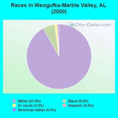
- 3,80391.8%White alone
- 2506.0%Black alone
- 401.0%Two or more races
- 260.6%Hispanic
- 210.5%American Indian alone
- 20.05%Other race alone
 Recent articles from our blog. Our writers, many of them Ph.D. graduates or candidates, create easy-to-read articles on a wide variety of topics.
Current Local Time: CST time zone
Land area: 303.7 square miles.
Population density: 12 people per square mile (very low).
| Weogufka-Marble Valley CCD: | 0.3% ($199) |
| Alabama: | 0.4% ($289) |
Nearest city with pop. 50,000+: Hoover, AL  (37.1 miles , pop. 62,742).
Nearest city with pop. 200,000+: Birmingham, AL (44.6 miles , pop. 242,820).
Nearest city with pop. 1,000,000+: Houston, TX (578.2 miles , pop. 1,953,631).
Nearest cities:
), ), ), ), Latitude: 33.01 N, Longitude: 86.35 W
Area code commonly used in this area: 256
| Here: | 2.8% |
| Alabama: | 2.6% |
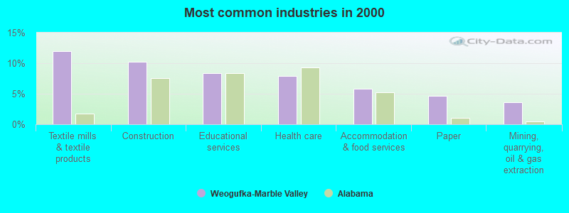
- Textile mills & textile products (11.9%)
- Construction (10.3%)
- Educational services (8.4%)
- Health care (7.9%)
- Accommodation & food services (5.8%)
- Paper (4.6%)
- Mining, quarrying, oil & gas extraction (3.6%)

- Construction (17.1%)
- Textile mills & textile products (10.5%)
- Paper (7.4%)
- Accommodation & food services (5.5%)
- Mining, quarrying, oil & gas extraction (4.9%)
- Public administration (3.7%)
- Truck transportation (3.6%)
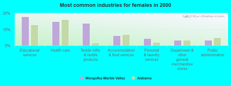
- Educational services (17.9%)
- Health care (14.9%)
- Textile mills & textile products (13.8%)
- Accommodation & food services (6.3%)
- Personal & laundry services (4.5%)
- Department & other general merchandise stores (3.3%)
- Public administration (3.3%)
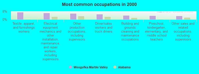
- Textile, apparel, and furnishings workers (7.2%)
- Electrical equipment mechanics and other installation, maintenance, and repair workers, including supervisors (6.5%)
- Other production occupations, including supervisors (6.2%)
- Driver/sales workers and truck drivers (5.3%)
- Building and grounds cleaning and maintenance occupations (4.1%)
- Preschool, kindergarten, elementary, and middle school teachers (3.9%)
- Other sales and related occupations, including supervisors (3.8%)
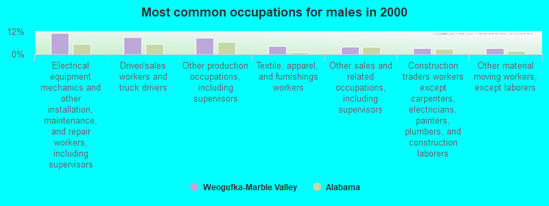
- Electrical equipment mechanics and other installation, maintenance, and repair workers, including supervisors (11.4%)
- Driver/sales workers and truck drivers (9.2%)
- Other production occupations, including supervisors (8.6%)
- Textile, apparel, and furnishings workers (4.4%)
- Other sales and related occupations, including supervisors (4.1%)
- Construction traders workers except carpenters, electricians, painters, plumbers, and construction laborers (3.4%)
- Other material moving workers, except laborers (3.3%)
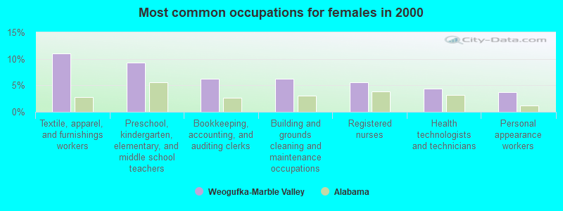
- Textile, apparel, and furnishings workers (11.0%)
- Preschool, kindergarten, elementary, and middle school teachers (9.2%)
- Bookkeeping, accounting, and auditing clerks (6.3%)
- Building and grounds cleaning and maintenance occupations (6.3%)
- Registered nurses (5.5%)
- Health technologists and technicians (4.4%)
- Personal appearance workers (3.7%)
Average climate in Weogufka-Marble Valley, Alabama
Based on data reported by over 4,000 weather stations


Tornado activity:
Weogufka-Marble Valley-area historical tornado activity is near Alabama state average. It is 90% greater than the overall U.S. average.
On 1/24/1964, a category F4 (max. wind speeds 207-260 mph) tornado 22.1 miles away from the Weogufka-Marble Valley place center killed 10 people and injured 6 people and caused between $50,000 and $500,000 in damages.
On 5/1/1953, a category F4 tornado 28.6 miles away from the place center killed 7 people and injured 12 people and caused between $50,000 and $500,000 in damages.
Earthquake activity:
Weogufka-Marble Valley-area historical earthquake activity is significantly above Alabama state average. It is 93% greater than the overall U.S. average.On 1/18/1999 at 07:00:53, a magnitude 4.8 (4.8 MB, 4.0 LG, Depth: 0.6 mi, Class: Light, Intensity: IV - V) earthquake occurred 59.0 miles away from the city center
On 4/29/2003 at 08:59:39, a magnitude 4.9 (4.4 MB, 4.6 MW, 4.9 LG) earthquake occurred 111.0 miles away from the city center
On 10/24/1997 at 08:35:17, a magnitude 4.9 (4.8 MB, 4.2 MS, 4.9 LG, Depth: 6.2 mi) earthquake occurred 141.0 miles away from Weogufka-Marble Valley center
On 4/29/2003 at 08:59:39, a magnitude 4.6 (4.6 MW, Depth: 12.3 mi) earthquake occurred 111.0 miles away from Weogufka-Marble Valley center
On 6/24/1975 at 11:11:36, a magnitude 4.5 (4.5 MB) earthquake occurred 99.0 miles away from the city center
On 11/7/2004 at 11:20:21, a magnitude 4.3 (4.3 MW, Depth: 3.1 mi) earthquake occurred 95.1 miles away from Weogufka-Marble Valley center
Magnitude types: regional Lg-wave magnitude (LG), body-wave magnitude (MB), surface-wave magnitude (MS), moment magnitude (MW)
Natural disasters:
The number of natural disasters in Coosa County (16) is near the US average (15).Major Disasters (Presidential) Declared: 8
Emergencies Declared: 6
Causes of natural disasters: Hurricanes: 6, Storms: 6, Floods: 5, Tornadoes: 5, Winds: 4, Drought: 1, Snowfall: 1, Winter Storm: 1, Other: 1 (Note: some incidents may be assigned to more than one category).
Hospitals and medical centers near Weogufka-Marble Valley:
- MID-SOUTH HOME HEALTH (Home Health Center, about 13 miles away; SYLACAUGA, AL)
- SYLACAUGA DIALYSIS (Dialysis Facility, about 13 miles away; SYLACAUGA, AL)
- SYLACAUGA HEALTH AND REHAB SERVICES (Nursing Home, about 13 miles away; SYLACAUGA, AL)
- COOSA VALLEY HOMECARE (Home Health Center, about 13 miles away; SYLACAUGA, AL)
- COOSA VALLEY MEDICAL CENTER Acute Care Hospitals (about 13 miles away; SYLACAUGA, AL)
- COOSA VALLEY NURSING FACILITY (Nursing Home, about 13 miles away; SYLACAUGA, AL)
- FMC SYLACAUGA (Dialysis Facility, about 13 miles away; SYLACAUGA, AL)
Colleges/universities with over 2000 students nearest to Weogufka-Marble Valley:
- University of Montevallo (about 31 miles; Montevallo, AL; Full-time enrollment: 2,826)
- Samford University (about 41 miles; Birmingham, AL; FT enrollment: 3,829)
- Virginia College-Birmingham (about 42 miles; Birmingham, AL; FT enrollment: 8,167)
- University of Alabama at Birmingham (about 44 miles; Birmingham, AL; FT enrollment: 14,853)
- Lawson State Community College-Birmingham Campus (about 44 miles; Birmingham, AL; FT enrollment: 2,695)
- Faulkner University (about 44 miles; Montgomery, AL; FT enrollment: 2,887)
- Alabama State University (about 45 miles; Montgomery, AL; FT enrollment: 5,457)
Points of interest:
Notable locations in Weogufka-Marble Valley: Paty Fishing Camp (A), Flag Mountain Lookout Tower (B), Little Toms Fish Camp (C), Little Joes Fish Camp (D), Cedar Circle Fish Camp (E), Blue Springs Fish Camp (F), Blackmons Landing (G), Horse Stomp Campground (H), Weogufka Volunteer Fire Department (I), Saint Clair County Courthouse (J), Marble Valley Volunteer Fire Department (K), Hanover Volunteer Fire Department (L), Stewartville Volunteer Fire Department (M). Display/hide their locations on the map
Churches in Weogufka-Marble Valley include: Newsite Church (A), Mount Moriah Baptist Church (B), Salem Church (C), Shady Grove Church (D), Poplar Springs Baptist Church (E), Union Baptist Church (F), Stewartville Church of God (G), Parkdale Church (H), Mount Olive Baptist Church (I). Display/hide their locations on the map
Cemeteries: Jennings Cemetery (1), Duke Cemetery (2), Quinsey Cemetery (3), Weogufka Cemetery (4), Unity Cemetery (5), Stewarts Cemetery (6), Poplar Springs Cemetery (7). Display/hide their locations on the map
Reservoirs: Kauls Lake (A), Thomas Lake (B). Display/hide their locations on the map
Streams, rivers, and creeks: Stewart Branch (A), Spivey Creek (B), Spear Branch (C), Slaughter Creek (D), Shelton Creek (E), Rocky Branch (F), Rock Branch (G), Pinefiold Branch (H), Paint Creek (I). Display/hide their locations on the map
Park in Weogufka-Marble Valley: Dickson Park (1). Display/hide its location on the map
| This place: | 2.5 people |
| Alabama: | 2.5 people |
| This place: | 71.2% |
| Whole state: | 67.8% |
| This place: | 6.0% |
| Whole state: | 4.7% |
Likely homosexual households (counted as self-reported same-sex unmarried-partner households)
- Lesbian couples: 0.3% of all households
- Gay men: 0.0% of all households
| This place: | 10.3% |
| Whole state: | 16.1% |
| This place: | 4.8% |
| Whole state: | 7.3% |
For population 15 years and over in Weogufka-Marble Valley:
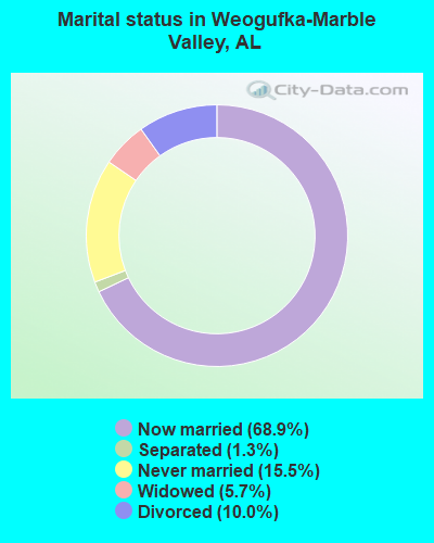
- Never married: 15.5%
- Now married: 68.9%
- Separated: 1.3%
- Widowed: 5.7%
- Divorced: 10.0%
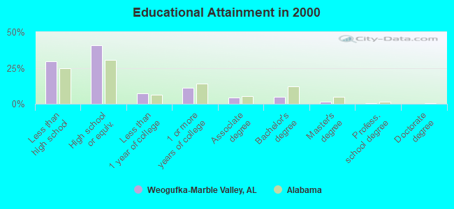
For population 25 years and over in Weogufka-Marble Valley:
- High school or higher: 70.4%
- Bachelor's degree or higher: 6.8%
- Graduate or professional degree: 2.0%
- Unemployed: 6.7%
- Mean travel time to work (commute): 29.3 minutes
| Here: | 11.6 |
| Alabama average: | 13.2 |
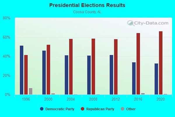
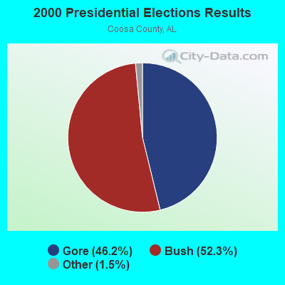
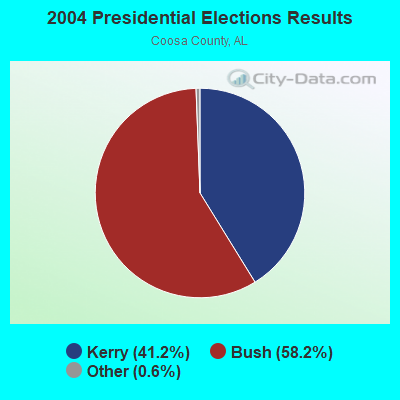
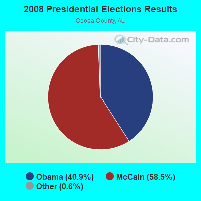
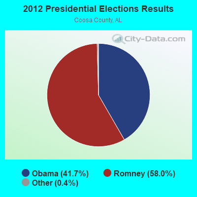
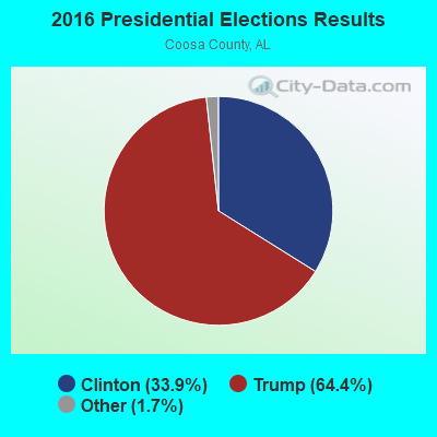

Graphs represent county-level data. Detailed 2008 Election Results
Religion statistics for Weogufka-Marble Valley, AL (based on Coosa County data)
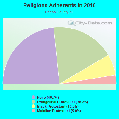
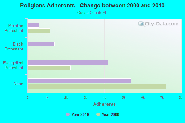
| Religion | Adherents | Congregations |
|---|---|---|
| Evangelical Protestant | 4,180 | 29 |
| Black Protestant | 1,388 | 10 |
| Mainline Protestant | 577 | 10 |
| Other | 3 | - |
| None | 5,391 | - |
Food Environment Statistics:
| Coosa County: | 0.92 / 10,000 pop. |
| State: | 0.65 / 10,000 pop. |
| This county: | 6.46 / 10,000 pop. |
| Alabama: | 6.32 / 10,000 pop. |
| Coosa County: | 12.9% |
| State: | 11.8% |
| Here: | 34.5% |
| Alabama: | 31.7% |
| This county: | 8.6% |
| State: | 13.5% |
Strongest AM radio stations in Weogufka-Marble Valley:
- WJOX (690 AM; 50 kW; BIRMINGHAM, AL; Owner: CITADEL BROADCASTING COMPANY)
- WDJC (850 AM; 50 kW; BIRMINGHAM, AL; Owner: KIMTRON, INC.)
- WAPI (1070 AM; 50 kW; BIRMINGHAM, AL; Owner: CITADEL BROADCASTING COMPANY)
- WNSI (810 AM; 50 kW; JACKSONVILLE, AL; Owner: UNITED BROADCASTING NETWORK, INC.)
- WMSP (740 AM; 10 kW; MONTGOMERY, AL; Owner: CUMULUS LICENSING CORP.)
- WKNG (1060 AM; daytime; 50 kW; TALLAPOOSA, GA; Owner: WKNG, INC.)
- WACV (1170 AM; 10 kW; MONTGOMERY, AL; Owner: MONTGOMERY BROADCAST PROPERTIES, LTD)
- WGST (640 AM; 50 kW; ATLANTA, GA; Owner: CITICASTERS LICENSES, L.P.)
- WZZX (780 AM; daytime; 5 kW; LINEVILLE, AL; Owner: ROBERT A. PERRY)
- WFEB (1340 AM; 1 kW; SYLACAUGA, AL; Owner: ALABAMA BROADCASTING COMPANY, INC.)
- WYEA (1290 AM; 1 kW; SYLACAUGA, AL; Owner: SPIRIT BROADCASTING CO., INC.)
- WCNN (680 AM; 50 kW; NORTH ATLANTA, GA; Owner: DICKEY BROADCASTING COMPANY)
- WSB (750 AM; 50 kW; ATLANTA, GA; Owner: CXR HOLDINGS, INC.)
Strongest FM radio stations in Weogufka-Marble Valley:
- WTRB-FM (98.3 FM; SYLACAUGA, AL; Owner: WILLIAMS COMMUNICATIONS, INC.)
- WLWI-FM (92.3 FM; MONTGOMERY, AL; Owner: CUMULUS LICENSING CORP.)
- WTBJ (91.3 FM; OXFORD, AL; Owner: TRINITY CHRISTIAN ACADEMY)
- WTDR (92.7 FM; TALLADEGA, AL; Owner: JACOBS BROADCAST GROUP, INC.)
- WGIB (91.9 FM; BIRMINGHAM, AL; Owner: GLEN IRIS BAPTIST SCHOOL)
- WBHK (98.7 FM; WARRIOR, AL; Owner: CXR HOLDINGS, INC.)
- WBPT (106.9 FM; BIRMINGHAM, AL; Owner: CXR HOLDINGS, INC.)
- WZZK-FM (104.7 FM; BIRMINGHAM, AL; Owner: CXR HOLDINGS, INC.)
- WODL (97.3 FM; HOMEWOOD, AL; Owner: CXR HOLDINGS, INC.)
- WQEM (101.5 FM; COLUMBIANA, AL; Owner: GLEN IRIS BAPTIST SCHOOL)
- WBHM (90.3 FM; BIRMINGHAM, AL; Owner: BD OF TRUSTEES/U OF AL AT BIRMINGHAM)
- WMXS (103.3 FM; MONTGOMERY, AL; Owner: CUMULUS LICENSING CORP.)
- WYSF (94.5 FM; BIRMINGHAM, AL; Owner: CITADEL BROADCASTING COMPANY)
- WMJJ (96.5 FM; BIRMINGHAM, AL; Owner: CAPSTAR TX LIMITED PARTNERSHIP)
- WQEN (103.7 FM; GADSDEN, AL; Owner: CAPSTAR TX LIMITED PARTNERSHIP)
- WBAM-FM (98.9 FM; MONTGOMERY, AL; Owner: DEEP SOUTH BROADCASTING COMPANY)
- WHHY-FM (101.9 FM; MONTGOMERY, AL; Owner: CUMULUS LICENSING CORP.)
- WEZZ-FM (97.7 FM; CLANTON, AL; Owner: SOUTHEASTERN BROADCASTING CO., INC)
- WZRR (99.5 FM; BIRMINGHAM, AL; Owner: CITADEL BROADCASTING COMPANY)
- WDJC-FM (93.7 FM; BIRMINGHAM, AL; Owner: KIMTRON, INC.)
TV broadcast stations around Weogufka-Marble Valley:
- WNCF (Channel 32; MONTGOMERY, AL; Owner: CHANNEL 32 MONTGOMERY LLC)
- WBIH (Channel 29; SELMA, AL; Owner: FLINN BROADCASTING CORPORATION)
- WIAT (Channel 42; BIRMINGHAM, AL; Owner: MEDIA GENERAL COMMUNICATIONS, INC.)
- WBIQ (Channel 10; BIRMINGHAM, AL; Owner: ALABAMA EDUCATIONAL TELEVISION COMMISSION)
- WTTO (Channel 21; HOMEWOOD, AL; Owner: WTTO LICENSEE, LLC)
- WBRC (Channel 6; BIRMINGHAM, AL; Owner: WBRC LICENSE, INC.)
- WABM (Channel 68; BIRMINGHAM, AL; Owner: BIRMINGHAM (WABM-TV) LICENSEE, INC.)
- WMCF-TV (Channel 45; MONTGOMERY, AL; Owner: TRINITY BROADCASTING NETWORK)
- WVTM-TV (Channel 13; BIRMINGHAM, AL; Owner: BIRMINGHAM BROADCASTING (WVTM-TV), LLC)
- W04CB (Channel 4; SYLACAUGA, AL; Owner: MEDIA GENERAL COMMUNICATIONS, INC.)
- National Bridge Inventory (NBI) Statistics
- 1Number of bridges
- 20ft / 6.2mTotal length
- $1,315,000Total costs
- 3,417Total average daily traffic
- 239Total average daily truck traffic
- 4,784Total future (year 2038) average daily traffic
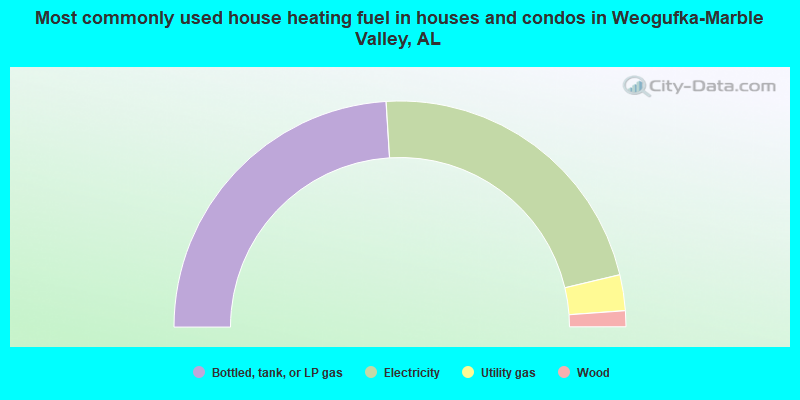
- 48.0%Bottled, tank, or LP gas
- 44.5%Electricity
- 5.1%Utility gas
- 2.3%Wood

- 70.3%Bottled, tank, or LP gas
- 14.8%Electricity
- 9.9%Utility gas
- 4.9%Wood
Weogufka-Marble Valley compared to Alabama state average:
- Median house value below state average.
- Unemployed percentage below state average.
- Black race population percentage significantly below state average.
- Hispanic race population percentage significantly below state average.
- Median age below state average.
- Foreign-born population percentage significantly below state average.
- Renting percentage below state average.
- Length of stay since moving in significantly above state average.
- Number of rooms per house significantly below state average.
- House age significantly below state average.
- Number of college students below state average.
- Percentage of population with a bachelor's degree or higher significantly below state average.