Wind River, Wyoming
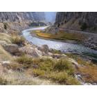
Wind River: Wind River
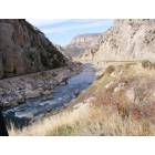
Wind River: Wind River Canyon

Wind River: Lower Green River Lake, Squaretop Mountain
- add
your
Submit your own pictures of this place and show them to the world
- OSM Map
- General Map
- Google Map
- MSN Map

| Males: 11,981 | |
| Females: 12,176 |
| Median resident age: | 35.0 years |
| Wyoming median age: | 36.2 years |
Zip code: 82501
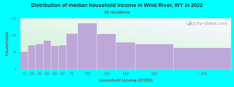
| Wind River: | $55,283 |
| WY: | $70,042 |
Estimated per capita income in 2022: $26,024 (it was $14,666 in 2000)
Wind River CCD income, earnings, and wages data
Estimated median house or condo value in 2022: $242,601 (it was $81,200 in 2000)
| Wind River: | $242,601 |
| WY: | $292,300 |
Detailed information about poverty and poor residents in Wind River, WY


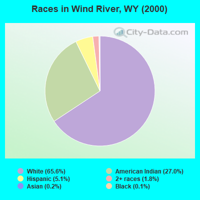
- 15,18465.6%White alone
- 6,25327.0%American Indian alone
- 1,1915.1%Hispanic
- 4281.8%Two or more races
- 460.2%Asian alone
- 290.1%Black alone
- 170.07%Other race alone
- 70.03%Native Hawaiian and Other
Pacific Islander alone
Races in Wind River detailed stats: ancestries, foreign born residents, place of birth
 Recent articles from our blog. Our writers, many of them Ph.D. graduates or candidates, create easy-to-read articles on a wide variety of topics.
Current Local Time: MST time zone
Elevation: 5592 feet
Land area: 3051.3 square miles.
Population density: 7.9 people per square mile (very low).
| Wind River CCD: | 0.7% ($563) |
| Wyoming: | 0.7% ($627) |
Nearest city with pop. 50,000+: Idaho Falls, ID  (172.7 miles , pop. 50,730).
Nearest city with pop. 200,000+: West Adams, CO (294.3 miles , pop. 259,628).
Nearest city with pop. 1,000,000+: Phoenix, AZ (690.4 miles , pop. 1,321,045).
Nearest cities:
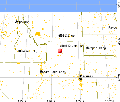
), ), )Latitude: 43.14 N, Longitude: 108.63 W
Area code commonly used in this area: 307

| Here: | 2.8% |
| Wyoming: | 2.5% |
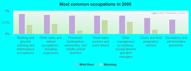
- Building and grounds cleaning and maintenance occupations (4.4%)
- Other sales and related occupations, including supervisors (4.2%)
- Preschool, kindergarten, elementary, and middle school teachers (4.0%)
- Driver/sales workers and truck drivers (4.0%)
- Other management occupations, except farmers and farm managers (4.0%)
- Cooks and food preparation workers (3.5%)
- Secretaries and administrative assistants (3.1%)
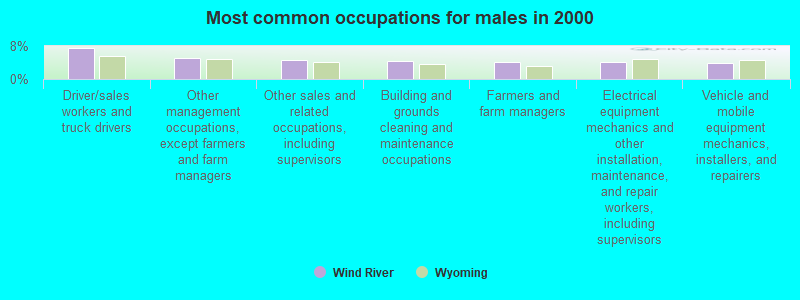
- Driver/sales workers and truck drivers (7.6%)
- Other management occupations, except farmers and farm managers (5.0%)
- Other sales and related occupations, including supervisors (4.7%)
- Building and grounds cleaning and maintenance occupations (4.4%)
- Farmers and farm managers (4.0%)
- Electrical equipment mechanics and other installation, maintenance, and repair workers, including supervisors (4.0%)
- Vehicle and mobile equipment mechanics, installers, and repairers (3.8%)
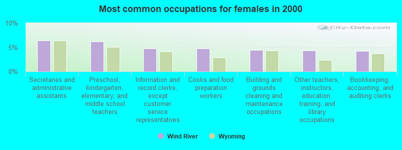
- Secretaries and administrative assistants (6.4%)
- Preschool, kindergarten, elementary, and middle school teachers (6.2%)
- Information and record clerks, except customer service representatives (4.8%)
- Cooks and food preparation workers (4.8%)
- Building and grounds cleaning and maintenance occupations (4.4%)
- Other teachers, instructors, education, training, and library occupations (4.3%)
- Bookkeeping, accounting, and auditing clerks (4.2%)
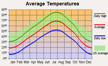
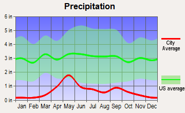
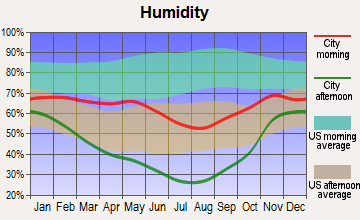
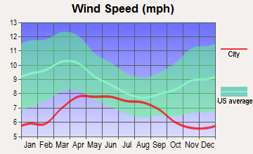
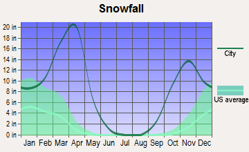
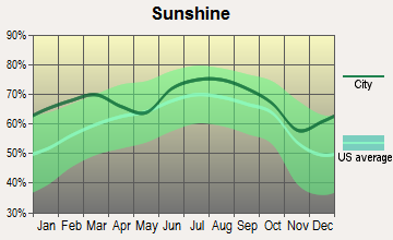
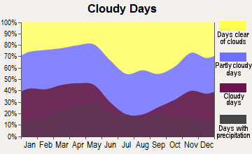
Average climate in Wind River, Wyoming
Based on data reported by over 4,000 weather stations
(lower is better)
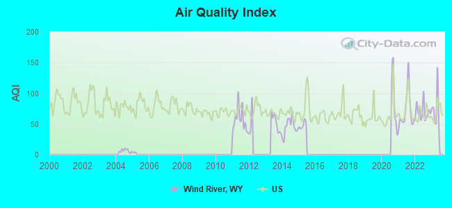
Air Quality Index (AQI) level in 2022 was 70.0. This is about average.
| City: | 70.0 |
| U.S.: | 72.6 |
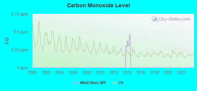
Carbon Monoxide (CO) [ppm] level in 2014 was 0.173. This is significantly better than average. Closest monitor was 16.8 miles away from the city center.
| City: | 0.173 |
| U.S.: | 0.251 |
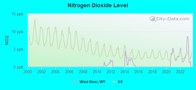
Nitrogen Dioxide (NO2) [ppb] level in 2022 was 3.13. This is significantly better than average. Closest monitor was 8.6 miles away from the city center.
| City: | 3.13 |
| U.S.: | 5.11 |
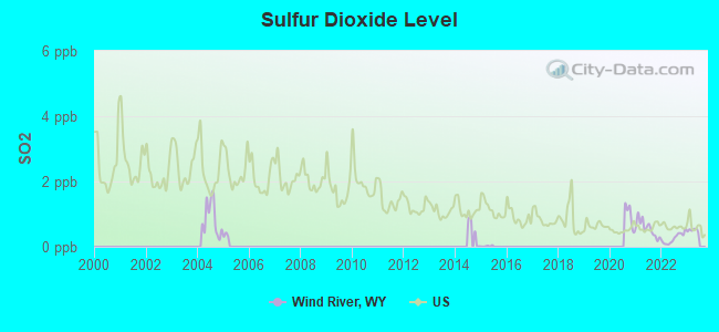
Sulfur Dioxide (SO2) [ppb] level in 2022 was 0.259. This is significantly better than average. Closest monitor was 15.9 miles away from the city center.
| City: | 0.259 |
| U.S.: | 1.515 |
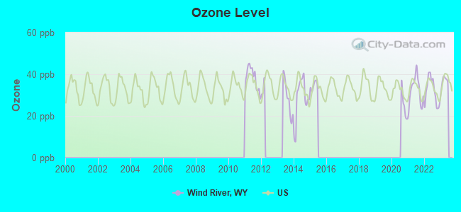
Ozone [ppb] level in 2022 was 31.8. This is about average. Closest monitor was 8.6 miles away from the city center.
| City: | 31.8 |
| U.S.: | 33.3 |
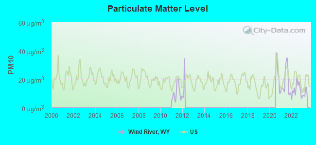
Particulate Matter (PM10) [µg/m3] level in 2022 was 12.9. This is significantly better than average. Closest monitor was 8.6 miles away from the city center.
| City: | 12.9 |
| U.S.: | 19.2 |
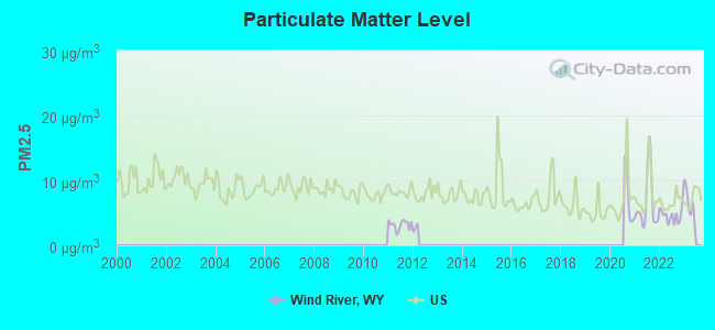
Particulate Matter (PM2.5) [µg/m3] level in 2022 was 4.58. This is significantly better than average. Closest monitor was 8.6 miles away from the city center.
| City: | 4.58 |
| U.S.: | 8.11 |
Earthquake activity:
Wind River-area historical earthquake activity is significantly above Wyoming state average. It is 1139% greater than the overall U.S. average.On 8/18/1959 at 06:37:13, a magnitude 7.7 (7.7 UK, Class: Major, Intensity: VIII - XII) earthquake occurred 140.9 miles away from Wind River center, causing $26,000,000 total damage
On 10/28/1983 at 14:06:06, a magnitude 7.3 (6.2 MB, 7.3 MS, 7.0 MW) earthquake occurred 266.7 miles away from Wind River center, causing 2 deaths (2 shaking deaths) and 3 injuries, causing $15,000,000 total damage
On 6/30/1975 at 18:54:13, a magnitude 6.1 (5.6 MB, 5.9 MS, 6.1 UK, 6.1 ML, Class: Strong, Intensity: VII - IX) earthquake occurred 149.0 miles away from the city center
On 2/3/1994 at 09:05:04, a magnitude 5.8 (5.4 MB, 5.5 MS, 5.8 MW, 5.8 ML, Depth: 4.9 mi, Class: Moderate, Intensity: VI - VII) earthquake occurred 120.6 miles away from the city center
On 3/28/1975 at 02:31:05, a magnitude 6.2 (6.1 MB, 6.0 MS, 6.2 ML) earthquake occurred 210.6 miles away from Wind River center
On 10/3/1915 at 06:52:48, a magnitude 7.6 (7.6 UK) earthquake occurred 491.8 miles away from Wind River center
Magnitude types: body-wave magnitude (MB), local magnitude (ML), surface-wave magnitude (MS), moment magnitude (MW)
Natural disasters:
The number of natural disasters in Fremont County (4) is a lot smaller than the US average (15).Major Disasters (Presidential) Declared: 2
Causes of natural disasters: Floods: 3, Landslide: 1, Storm: 1, Other: 1 (Note: some incidents may be assigned to more than one category).
Hospitals and medical centers near Wind River:
- RIVERTON MEMORIAL HOSPITAL Acute Care Hospitals (about 14 miles away; RIVERTON, WY)
- LITTLE WIND HOSPICE, AN AMEDISYS COMPANY (Hospital, about 14 miles away; RIVERTON, WY)
- AMEDISYS HOME HEALTH OF RIVERTON (Home Health Center, about 15 miles away; RIVERTON, WY)
- KINDRED NURSING AND REHABILITATION - WIND RIVER (Nursing Home, about 15 miles away; RIVERTON, WY)
- WIND RIVER DIALYSIS CENTER (Dialysis Facility, about 16 miles away; FORT WASHAKIE, WY)
- MORNING STAR CARE CENTER (Nursing Home, about 16 miles away; FORT WASHAKIE, WY)
Colleges/universities with over 2000 students nearest to Wind River:
- Western Wyoming Community College (about 112 miles; Rock Springs, WY; Full-time enrollment: 2,086)
- Casper College (about 119 miles; Casper, WY; FT enrollment: 2,770)
- Sheridan College (about 141 miles; Sheridan, WY; FT enrollment: 2,070)
- Brigham Young University-Idaho (about 165 miles; Rexburg, ID; FT enrollment: 30,522)
- Montana State University-Billings (about 184 miles; Billings, MT; FT enrollment: 4,319)
- Utah State University (about 189 miles; Logan, UT; FT enrollment: 21,131)
- Idaho State University (about 193 miles; Pocatello, ID; FT enrollment: 10,350)
Points of interest:
Notable locations in Wind River: Mail Camp Ranger Station (A), Merriam Ranch (B), Paradise Valley Community House (C), Porter Cabin Cow Camp (D), Saint Lawrence Ranger Station (E), Riverton Country Club (F), Pilot Butte Power Plant (G), Shotgun Ranch (H), State Game and Fish Checking Station (I), Burgess Ranch (J), Delfelder (K), Holland Place (L), Laird (M), Neble (N), Wind River (O), Arapahoe Ranch (P), Bargee Ranch (Q), Boysen Camp (R), Bradford Ranch (S), Bull Lake Lodge (T). Display/hide their locations on the map
Churches in Wind River include: Saint Helen Church (A), Blessed Sacrament Church (B), Latter Day Saints Church (C), Missouri Valley Church (D), Saint James Church (E), Saint Edwards Church (F), Sunnyside Church (G), Union Church (H), Roberts Mission (I). Display/hide their locations on the map
Cemeteries: Shakespare Cemetery (1), Red Man Cemetery (2), Wallowing Bull Cemetery (3), White Plume Cemetery (4), Willow Cemetery (5), Yellow Calf Cemetery (6), Hurtado Cemetery (7). Display/hide their locations on the map
Lakes and reservoirs: Lake Kagevah (A), Wilson Creek Lakes (B), Hidden Lake (C), Pie Lake (D), Kirkland Lake (E), Steamboat Lake (F), Upper Dinwoody Lake (G), Lydle Lake (H). Display/hide their locations on the map
Streams, rivers, and creeks: McKee Grave Creek (A), McCaskey Drain (B), Marys Creek (C), Norkok Creek (D), Norkok Meadows Creek (E), Popo Agie River (F), Lost Creek (G), Little Wind River (H), Antelope Springs Creek (I). Display/hide their locations on the map
Park in Wind River: Diversion Dam Park (1). Display/hide its location on the map
| This place: | 2.7 people |
| Wyoming: | 2.4 people |
| This place: | 69.2% |
| Whole state: | 64.6% |
| This place: | 9.0% |
| Whole state: | 7.1% |
Likely homosexual households (counted as self-reported same-sex unmarried-partner households)
- Lesbian couples: 0.6% of all households
- Gay men: 0.4% of all households
| This place: | 21.0% |
| Whole state: | 11.4% |
| This place: | 10.1% |
| Whole state: | 4.5% |
People in group quarters in Wind River in 2010:
- 210 people in state prisons
- 206 people in college/university student housing
- 110 people in nursing facilities/skilled-nursing facilities
- 37 people in residential treatment centers for adults
- 24 people in local jails and other municipal confinement facilities
- 17 people in group homes intended for adults
- 12 people in emergency and transitional shelters (with sleeping facilities) for people experiencing homelessness
- 6 people in group homes for juveniles (non-correctional)
- 4 people in other noninstitutional facilities
People in group quarters in Wind River in 2000:
- 129 people in state prisons
- 123 people in nursing homes
- 112 people in college dormitories (includes college quarters off campus)
- 40 people in other group homes
- 38 people in other noninstitutional group quarters
- 26 people in religious group quarters
- 17 people in homes for the mentally retarded
- 12 people in other types of correctional institutions
For population 15 years and over in Wind River:
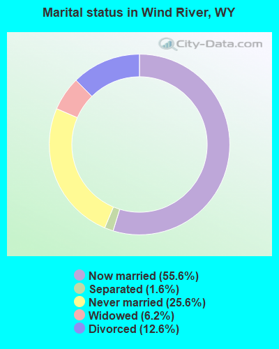
- Never married: 25.6%
- Now married: 55.6%
- Separated: 1.6%
- Widowed: 6.2%
- Divorced: 12.6%
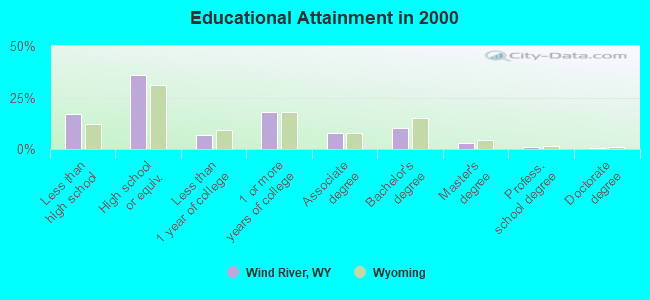
For population 25 years and over in Wind River:
- High school or higher: 83.1%
- Bachelor's degree or higher: 14.7%
- Graduate or professional degree: 4.3%
- Unemployed: 11.5%
- Mean travel time to work (commute): 16.2 minutes
| Here: | 9.7 |
| Wyoming average: | 10.0 |
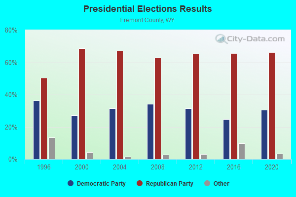
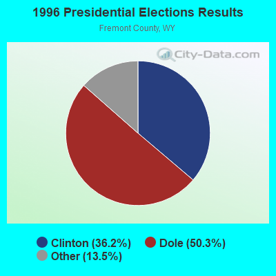
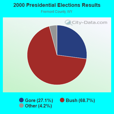
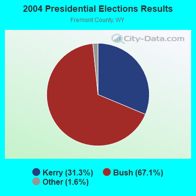

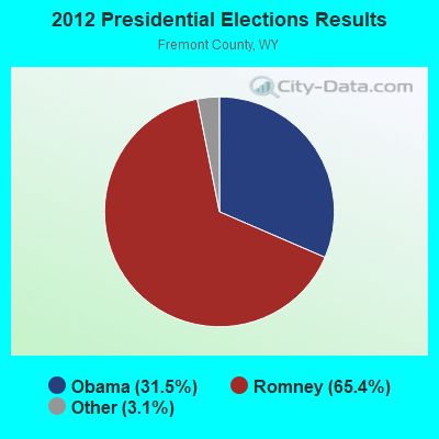
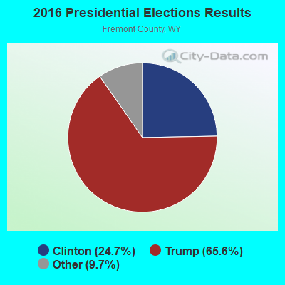

Graphs represent county-level data. Detailed 2008 Election Results
Religion statistics for Wind River, WY (based on Fremont County data)
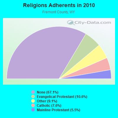
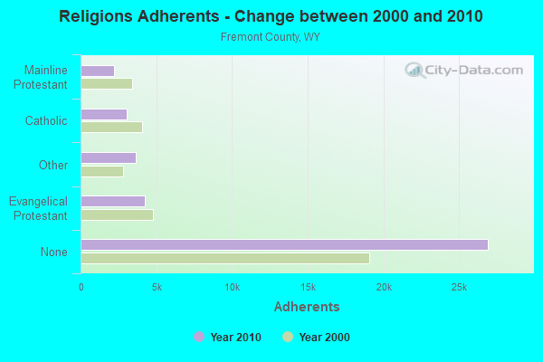
| Religion | Adherents | Congregations |
|---|---|---|
| Evangelical Protestant | 4,269 | 50 |
| Other | 3,658 | 12 |
| Catholic | 3,047 | 10 |
| Mainline Protestant | 2,219 | 16 |
| None | 26,930 | - |
Food Environment Statistics:
| This county: | 2.67 / 10,000 pop. |
| Wyoming: | 2.10 / 10,000 pop. |
| Fremont County: | 0.27 / 10,000 pop. |
| Wyoming: | 0.27 / 10,000 pop. |
| Here: | 1.07 / 10,000 pop. |
| State: | 0.65 / 10,000 pop. |
| Here: | 3.74 / 10,000 pop. |
| Wyoming: | 5.36 / 10,000 pop. |
| Fremont County: | 9.61 / 10,000 pop. |
| Wyoming: | 10.08 / 10,000 pop. |
| This county: | 8.0% |
| Wyoming: | 7.1% |
| Fremont County: | 26.0% |
| State: | 24.4% |
Strongest AM radio stations in Wind River:
- KOVE (1330 AM; 5 kW; LANDER, WY; Owner: FREMONT BROADCASTING, INC.)
- KTWO (1030 AM; 50 kW; CASPER, WY; Owner: CITICASTERS LICENSES, L.P.)
- KVOW (1450 AM; 1 kW; RIVERTON, WY; Owner: EDWARDS COMMUNICATIONS, LC)
- KUYO (830 AM; daytime; 25 kW; EVANSVILLE, WY; Owner: WYOMING CHRISTIAN BROADCASTING COMPANY)
- KALL (700 AM; 50 kW; NORTH SALT LAKE CITY, UT; Owner: CITICASTERS LICENSES, L.P.)
- KZMQ (1140 AM; daytime; 10 kW; GREYBULL, WY; Owner: LEGEND COMMUNICATIONS OF WYOMING LLC)
- KIQN (1010 AM; 50 kW; TOOELE, UT)
- KLTT (670 AM; 50 kW; COMMERCE CITY, CO; Owner: KLZ RADIO, INC.)
- KKZN (760 AM; 50 kW; THORNTON, CO; Owner: JACOR BROADCASTING OF COLORADO, INC.)
- KSL (1160 AM; 50 kW; SALT LAKE CITY, UT; Owner: BONNEVILLE HOLDING COMPANY)
- KOA (850 AM; 50 kW; DENVER, CO; Owner: JACOR BROADCASTING OF COLORADO, INC.)
- KNZZ (1100 AM; 50 kW; GRAND JUNCTION, CO; Owner: M B C GRAND BROADCASTING, INC.)
- KIMB (1260 AM; 50 kW; KIMBALL, NE; Owner: G & L INVESTMENTS, LLC)
Strongest FM radio stations in Wind River:
- KDNO (101.7 FM; THERMOPOLIS, WY; Owner: CARJIM, LLC)
- KWRR (89.5 FM; ETHETE, WY; Owner: BUSINESS COUNCIL OF THE NORTHERN ARAPAHO TRIBE)
- KWYW (99.1 FM; LOST CABIN, WY; Owner: JIMMY RAY CARROLL)
- KDLY (97.5 FM; LANDER, WY; Owner: FREMONT BROADCASTING, INC.)
- KCWC-FM (88.1 FM; RIVERTON, WY; Owner: CENTRAL WYOMING COLLEGE)
- K244DP (96.7 FM; LANDER, WY; Owner: WESTERN INSPIRATIONAL BROADCASTERS, INC)
- K276DV (103.1 FM; EDEN, WY; Owner: WESTERN INSPIRATIONAL BROADCASTERS)
- KTAK (93.9 FM; RIVERTON, WY; Owner: EDWARDS COMMUNICATIONS, LC)
- KTRZ (93.1 FM; RIVERTON, WY; Owner: JIMMY RAY CARROLL)
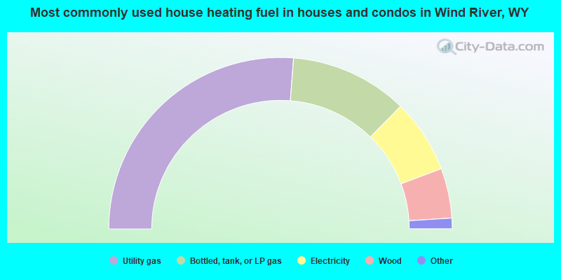
- 52.5%Utility gas
- 22.2%Bottled, tank, or LP gas
- 14.0%Electricity
- 9.4%Wood
- 0.8%Coal or coke
- 0.6%Fuel oil, kerosene, etc.
- 0.3%Other fuel
- 0.1%Solar energy
- 0.1%No fuel used
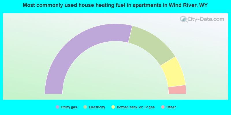
- 57.7%Utility gas
- 24.4%Electricity
- 13.8%Bottled, tank, or LP gas
- 3.0%Wood
- 1.0%Other fuel
Wind River compared to Wyoming state average:
- Black race population percentage significantly below state average.
- Hispanic race population percentage below state average.
- Median age below state average.
- Foreign-born population percentage significantly below state average.
- Length of stay since moving in significantly above state average.
- Number of rooms per house significantly below state average.
- House age significantly below state average.
Wind River on our top lists:
- #11 on the list of "Top 101 cities with largest percentage of males in occupations: extraction workers (population 5,000+)"
- #11 on the list of "Top 101 cities with largest percentage of males in industries: farm product raw materials merchant wholesalers (population 5,000+)"
- #17 on the list of "Top 101 cities with largest percentage of females in industries: farm product raw materials merchant wholesalers (population 5,000+)"
- #24 on the list of "Top 100 cities with largest land areas"
- #28 on the list of "Top 101 cities with largest percentage of females in industries: social assistance (population 5,000+)"
- #49 on the list of "Top 101 cities with largest percentage of females in occupations: cooks and food preparation workers (population 5,000+)"
- #52 on the list of "Top 101 cities with largest percentage of males in industries: social assistance (population 5,000+)"
- #56 on the list of "Top 101 cities with largest percentage of males in occupations: farmers and farm managers (population 5,000+)"
- #64 on the list of "Top 101 cities with largest percentage of females in occupations: other transportation workers (population 5,000+)"
- #65 on the list of "Top 101 cities with largest percentage of females in industries: petroleum and petroleum products merchant wholesalers (population 5,000+)"
- #68 on the list of "Top 101 cities with largest percentage of males in occupations: occupational and physical therapist assistants and aides (population 5,000+)"
- #73 on the list of "Top 101 cities with largest percentage of males in industries: truck transportation (population 5,000+)"
- #82 on the list of "Top 101 cities with largest percentage of females in occupations: farmers and farm managers (population 5,000+)"
- #87 on the list of "Top 101 cities with largest percentage of females in industries: retail florists (population 5,000+)"
- #97 on the list of "Top 100 highest located cities (pop. 5,000+)"
- #9 on the list of "Top 101 counties with the highest Ozone (1-hour) air pollution readings in 2012 (ppm)"
- #13 on the list of "Top 101 counties with the lowest Particulate Matter (PM2.5) Annual air pollution readings in 2012 (µg/m3)"
- #16 on the list of "Top 101 counties with the lowest Nitrogen Dioxide air pollution readings in 2012 (ppm)"
- #26 on the list of "Top 101 counties with the lowest Particulate Matter (PM10) Annual air pollution readings in 2012 (µg/m3)"
- #27 on the list of "Top 101 counties with the lowest percentage of residents that visited a dentist within the past year"