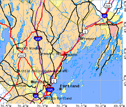
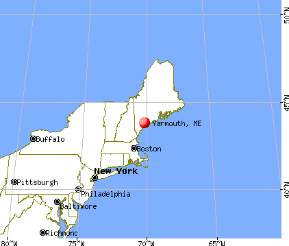
Yarmouth, Maine
Submit your own pictures of this place and show them to the world
- OSM Map
- General Map
- Google Map
- MSN Map
Population change since 2000: +64.9%
| Males: 2,653 | |
| Females: 3,216 |
| Median resident age: | 39.6 years |
| Maine median age: | 45.1 years |
Zip codes: 04096.
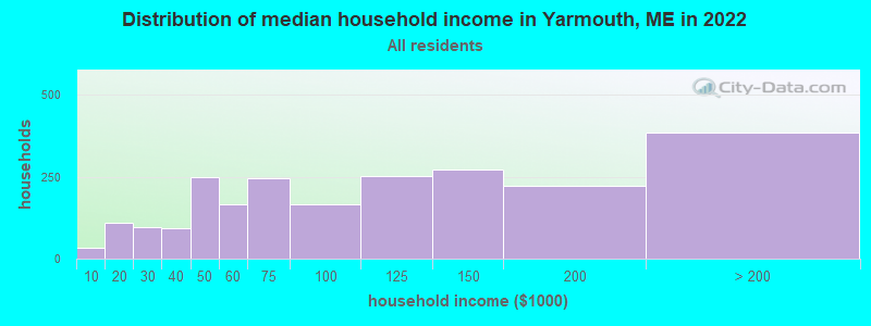
| Yarmouth: | $91,443 |
| ME: | $69,543 |
Estimated per capita income in 2022: $54,491 (it was $29,599 in 2000)
Yarmouth CDP income, earnings, and wages data
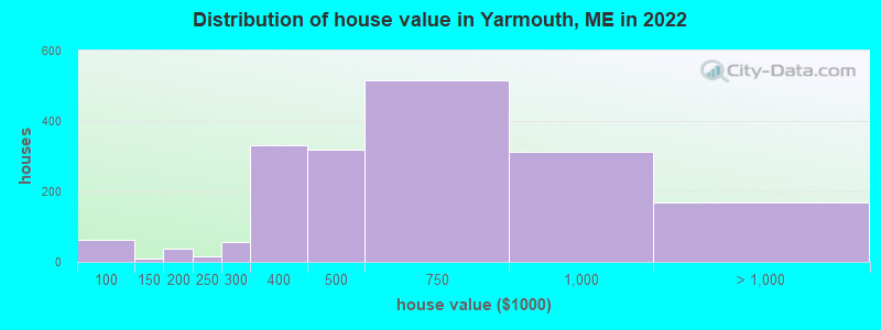
Estimated median house or condo value in 2022: $560,555 (it was $183,000 in 2000)
| Yarmouth: | $560,555 |
| ME: | $290,600 |
Mean prices in 2022: all housing units: $485,947; detached houses: $518,301; townhouses or other attached units: $411,184; in 2-unit structures: $236,901; mobile homes: $170,805
Median gross rent in 2022: $1,599.
(17.5% for White Non-Hispanic residents, 0.7% for Hispanic or Latino residents, 100.0% for American Indian residents, 0.6% for two or more races residents)
Detailed information about poverty and poor residents in Yarmouth, ME

Compare current foreclosures near Yarmouth, ME:
| Photo | Address | Area | Beds / Baths | Price | Details |
|---|---|---|---|---|---|

|
#1
High St
Windham, ME 04062
|
933 sq. feet
|
1 baths 2 beds |
show details | |

|
#2
Pleasant St
Lisbon Falls, ME 04252
|
561 sq. feet
|
1 baths 2 beds |
show details | |

|
#3
Motorcycle Dr
Windham, ME 04062
|
2,772 sq. feet
|
2 baths 3 beds |
show details | |

|
#4
Spring St
Lisbon, ME 04250
|
1,141 sq. feet
|
1 baths 3 beds |
show details | |

|
#5
Pownal Rd
Auburn, ME 04210
|
1,099 sq. feet
|
1 baths 2 beds |
show details | |

|
#6
Bridge St
Westbrook, ME 04092
|
1,268 sq. feet
|
1 baths 2 beds |
show details | |

|
#7
Haskell St
Westbrook, ME 04092
|
1,573 sq. feet
|
1 baths 3 beds |
show details | |

|
#8
Running Brook Rd
Windham, ME 04062
|
1,749 sq. feet
|
2 baths 3 beds |
show details | |

|
#9
Bruce Hill Rd
Cumberland Center, ME 04021
|
2,536 sq. feet
|
2 baths 3 beds |
show details | |

|
#10
Emerson Dr
Windham, ME 04062
|
1,080 sq. feet
|
1 baths 3 beds |
show details |
| Photo | Address | Area | Beds / Baths | Price | Details |
|---|---|---|---|---|---|

|
#11
Windham Center Rd
Windham, ME 04062
|
1,576 sq. feet
|
1 baths 3 beds |
show details | |

|
#12
Cottage Rd
Windham, ME 04062
|
1,404 sq. feet
|
1 baths 2 beds |
show details | |

|
#13
Dollys Way
Scarborough, ME 04074
|
1,821 sq. feet
|
2 baths 3 beds |
show details | |

|
#14
Church St
Westbrook, ME 04092
|
1,529 sq. feet
|
1 baths 3 beds |
show details | |

|
#15
Majestic Hts
Windham, ME 04062
|
1,668 sq. feet
|
2 baths 3 beds |
show details | |

|
#16
Saco St Unit 2
Westbrook, ME 04092
|
1,725 sq. feet
|
2 baths 4 beds |
show details | |

|
#17
Jennifer Way
Gorham, ME 04038
|
1,414 sq. feet
|
1 baths 3 beds |
show details | |

|
#18
Coach Rd
South Portland, ME 04106
|
1,300 sq. feet
|
2 baths 3 beds |
show details | |

|
#19
Liza Harmon Dr Apt 128
Westbrook, ME 04092
|
- sq. feet
|
- baths - beds |
show details | |

|
#20
N Kelsey St Apt 2
South Portland, ME 04106
|
- sq. feet
|
- baths - beds |
show details |
| Photo | Address | Area | Beds / Baths | Price | Details |
|---|---|---|---|---|---|

|
#21
Cape Woods Dr
Cape Elizabeth, ME 04107
|
- sq. feet
|
- baths - beds |
show details | |

|
#22
Sargent St
Westbrook, ME 04092
|
- sq. feet
|
- baths - beds |
show details | |

|
#23
Devereaux Cir
South Portland, ME 04106
|
- sq. feet
|
- baths - beds |
show details | |

|
#24
Townhouse Dr
South Portland, ME 04106
|
- sq. feet
|
- baths - beds |
show details | |

|
#25
Wainwright Cir W
South Portland, ME 04106
|
- sq. feet
|
- baths - beds |
show details | |

|
#26
Main St Apt 15
South Portland, ME 04106
|
- sq. feet
|
- baths - beds |
show details | |

|
#27
Congress St Unit 307
Portland, ME 04101
|
- sq. feet
|
- baths - beds |
show details | |

|
#28
Congress St # 2
Portland, ME 04102
|
- sq. feet
|
- baths - beds |
show details | |

|
#29
Winter St Apt 2
Topsham, ME 04086
|
- sq. feet
|
- baths - beds |
show details | |

|
#30
Chase Ct
Freeport, ME 04032
|
- sq. feet
|
- baths - beds |
show details |
| Photo | Address | Area | Beds / Baths | Price | Details |
|---|---|---|---|---|---|

|
#31
Gray Rd
Cumberland Center, ME 04021
|
- sq. feet
|
- baths - beds |
show details | |

|
#32
Us Route 1, Apt 11
Scarborough, ME 04074
|
- sq. feet
|
- baths - beds |
show details | |

|
#33
Durham Rd
Freeport, ME 04032
|
- sq. feet
|
- baths - beds |
show details | |

|
#34
Yarmouth Rd
Gray, ME 04039
|
- sq. feet
|
- baths - beds |
show details | |

|
#35
Ballantyne Dr
Scarborough, ME 04074
|
- sq. feet
|
- baths - beds |
show details | |

|
#36
Ocean Ave
Portland, ME 04103
|
- sq. feet
|
- baths - beds |
show details | |

|
#37
Lambert St # C2
Portland, ME 04103
|
- sq. feet
|
- baths - beds |
show details | |

|
#38
Liberty Way
Portland, ME 04103
|
- sq. feet
|
- baths - beds |
show details | |

|
#39
Ocean Ave
Portland, ME 04103
|
- sq. feet
|
- baths - beds |
show details | |

|
#40
Scarborough Downs Rd
Scarborough, ME 04074
|
- sq. feet
|
- baths - beds |
show details |
| Photo | Address | Area | Beds / Baths | Price | Details |
|---|---|---|---|---|---|

|
#41
Pleasant Ave
Portland, ME 04103
|
- sq. feet
|
- baths - beds |
show details | |

|
#42
India St # 1
Portland, ME 04101
|
- sq. feet
|
- baths - beds |
show details | |

|
#43
Congress St
Portland, ME 04101
|
- sq. feet
|
- baths - beds |
show details | |

|
#44
Cumberland Ave # 302
Portland, ME 04101
|
- sq. feet
|
- baths - beds |
show details | |

|
#45
Park Ave Apt 2
Portland, ME 04101
|
- sq. feet
|
- baths - beds |
show details | |

|
#46
Bickford Ave
Brunswick, ME 04011
|
- sq. feet
|
- baths - beds |
show details | |

|
#47
Woodside Dr
Lisbon, ME 04250
|
- sq. feet
|
- baths - beds |
show details | |

|
#48
Wing St
Lisbon Falls, ME 04252
|
- sq. feet
|
- baths - beds |
show details | |

|
#49
Ward Cir
Brunswick, ME 04011
|
- sq. feet
|
- baths - beds |
show details | |

|
Check over 1 million property listings on Foreclosure.com!
|
browse all offers | |||


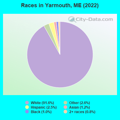
- 5,51191.6%White alone
- 1542.6%Other race alone
- 1512.5%Hispanic
- 741.2%Asian alone
- 601.0%Black alone
- 480.8%Two or more races
- 10.02%American Indian alone
Races in Yarmouth detailed stats: ancestries, foreign born residents, place of birth
According to our research of Maine and other state lists, there were 2 registered sex offenders living in Yarmouth, Maine as of April 25, 2024.
The ratio of all residents to sex offenders in Yarmouth is 2,893 to 1.
The ratio of registered sex offenders to all residents in this city is much lower than the state average.
Type |
2009 |
2010 |
2011 |
2012 |
2013 |
2014 |
2015 |
2016 |
2017 |
2018 |
2019 |
2020 |
2021 |
2022 |
|---|---|---|---|---|---|---|---|---|---|---|---|---|---|---|
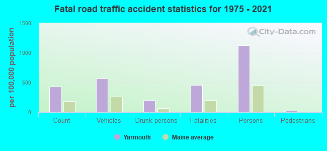
| Murders (per 100,000) | 0 (0.0) | 0 (0.0) | 0 (0.0) | 0 (0.0) | 0 (0.0) | 0 (0.0) | 0 (0.0) | 0 (0.0) | 0 (0.0) | 0 (0.0) | 0 (0.0) | 0 (0.0) | 0 (0.0) | 0 (0.0) |
| Rapes (per 100,000) | 1 (12.4) | 2 (24.0) | 0 (0.0) | 2 (23.9) | 2 (23.6) | 0 (0.0) | 1 (11.7) | 0 (0.0) | 2 (23.3) | 3 (35.3) | 2 (23.4) | 3 (34.8) | 2 (23.2) | 2 (22.2) |
| Robberies (per 100,000) | 1 (12.4) | 2 (24.0) | 0 (0.0) | 1 (11.9) | 1 (11.8) | 1 (11.7) | 0 (0.0) | 0 (0.0) | 0 (0.0) | 0 (0.0) | 1 (11.7) | 1 (11.6) | 1 (11.6) | 1 (11.1) |
| Assaults (per 100,000) | 0 (0.0) | 1 (12.0) | 1 (12.0) | 1 (11.9) | 3 (35.5) | 2 (23.5) | 1 (11.7) | 5 (58.2) | 4 (46.5) | 0 (0.0) | 0 (0.0) | 2 (23.2) | 0 (0.0) | 1 (11.1) |
| Burglaries (per 100,000) | 28 (347.0) | 12 (143.7) | 12 (143.7) | 21 (250.7) | 19 (224.6) | 11 (129.2) | 19 (222.2) | 8 (93.2) | 6 (69.8) | 7 (82.3) | 4 (46.8) | 4 (46.4) | 2 (23.2) | 1 (11.1) |
| Thefts (per 100,000) | 70 (867.5) | 76 (910.3) | 61 (730.7) | 56 (668.6) | 52 (614.7) | 57 (669.2) | 46 (537.9) | 58 (675.7) | 52 (605.1) | 24 (282.0) | 33 (386.4) | 49 (568.6) | 35 (405.7) | 47 (521.7) |
| Auto thefts (per 100,000) | 2 (24.8) | 3 (35.9) | 2 (24.0) | 1 (11.9) | 1 (11.8) | 6 (70.4) | 2 (23.4) | 2 (23.3) | 3 (34.9) | 1 (11.8) | 1 (11.7) | 1 (11.6) | 0 (0.0) | 1 (11.1) |
| Arson (per 100,000) | 1 (12.4) | 4 (47.9) | 0 (0.0) | 0 (0.0) | 1 (11.8) | 0 (0.0) | 0 (0.0) | 0 (0.0) | 0 (0.0) | 0 (0.0) | 0 (0.0) | 0 (0.0) | 0 (0.0) | 0 (0.0) |
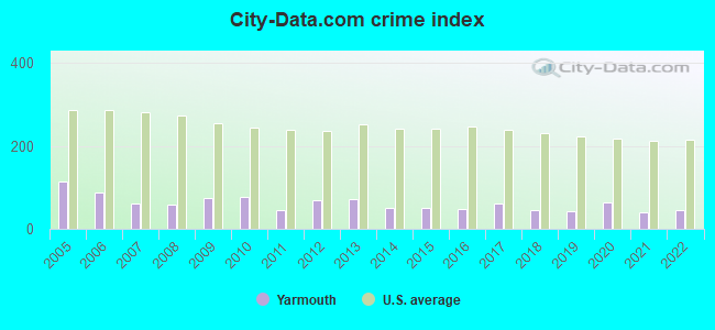
| City-Data.com crime index | 74.6 | 78.1 | 43.6 | 70.3 | 70.8 | 49.7 | 50.6 | 47.1 | 59.8 | 46.2 | 41.9 | 62.9 | 39.9 | 45.8 |
The City-Data.com crime index weighs serious crimes and violent crimes more heavily. Higher means more crime, U.S. average is 246.1. It adjusts for the number of visitors and daily workers commuting into cities.
Crime rate in Yarmouth detailed stats: murders, rapes, robberies, assaults, burglaries, thefts, arson
Full-time law enforcement employees in 2021, including police officers: 14 (13 officers - 12 male; 1 female).
| Officers per 1,000 residents here: | 1.51 |
| Maine average: | 1.71 |
 Recent articles from our blog. Our writers, many of them Ph.D. graduates or candidates, create easy-to-read articles on a wide variety of topics.


Latest news from Yarmouth, ME collected exclusively by city-data.com from local newspapers, TV, and radio stations
Yarmouth, ME City Guides:
Ancestries: Irish (16.0%), English (13.7%), French Canadian (6.5%), Scottish (5.1%), European (4.5%), American (4.3%).
Current Local Time: EST time zone
Incorporated on 08/08/1849
Elevation: 110 feet
Land area: 2.60 square miles.
Population density: 2,259 people per square mile (low).
234 residents are foreign born (1.6% Europe, 1.3% Asia, 0.9% Latin America).
| This place: | 3.9% |
| Maine: | 3.8% |
Median real estate property taxes paid for housing units with mortgages in 2022: $6,419 (1.1%)
Median real estate property taxes paid for housing units with no mortgage in 2022: $5,709 (1.1%)
Nearest city with pop. 50,000+: Portland, ME  (10.1 miles , pop. 64,249).
Nearest city with pop. 200,000+: Boston, MA (111.8 miles , pop. 589,141).
Nearest city with pop. 1,000,000+: Bronx, NY (277.7 miles , pop. 1,332,650).
Nearest cities:
), ), ), ), )Latitude: 43.80 N, Longitude: 70.19 W
Area code: 207
Yarmouth tourist attractions:
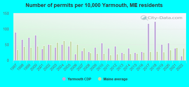
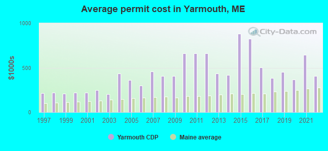
Single-family new house construction building permits:
- 2022: 5 buildings, average cost: $408,600
- 2021: 14 buildings, average cost: $644,300
- 2020: 20 buildings, average cost: $366,800
- 2019: 18 buildings, average cost: $453,100
- 2018: 44 buildings, average cost: $384,800
- 2017: 42 buildings, average cost: $502,300
- 2016: 10 buildings, average cost: $825,500
- 2015: 9 buildings, average cost: $882,600
- 2014: 14 buildings, average cost: $417,400
- 2013: 9 buildings, average cost: $433,000
- 2012: 16 buildings, average cost: $659,300
- 2011: 14 buildings, average cost: $659,300
- 2010: 20 buildings, average cost: $659,300
- 2009: 15 buildings, average cost: $407,500
- 2008: 10 buildings, average cost: $407,500
- 2007: 11 buildings, average cost: $455,600
- 2006: 7 buildings, average cost: $298,300
- 2005: 16 buildings, average cost: $361,800
- 2004: 18 buildings, average cost: $432,600
- 2003: 15 buildings, average cost: $203,500
- 2002: 18 buildings, average cost: $250,200
- 2001: 13 buildings, average cost: $221,900
- 2000: 29 buildings, average cost: $219,900
- 1999: 26 buildings, average cost: $211,200
- 1998: 24 buildings, average cost: $218,100
- 1997: 32 buildings, average cost: $214,400
| Here: | 2.8% |
| Maine: | 3.4% |
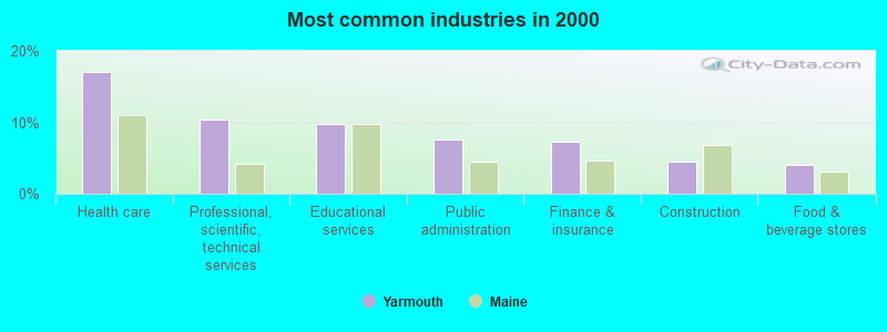
- Health care (17.1%)
- Professional, scientific, technical services (10.4%)
- Educational services (9.7%)
- Public administration (7.6%)
- Finance & insurance (7.3%)
- Construction (4.5%)
- Food & beverage stores (4.0%)

- Professional, scientific, technical services (11.8%)
- Health care (10.1%)
- Public administration (9.4%)
- Construction (7.4%)
- Finance & insurance (7.2%)
- Food & beverage stores (5.7%)
- Educational services (4.9%)
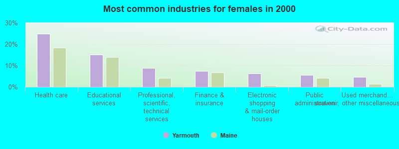
- Health care (24.9%)
- Educational services (15.1%)
- Professional, scientific, technical services (8.9%)
- Finance & insurance (7.5%)
- Electronic shopping & mail-order houses (6.4%)
- Public administration (5.6%)
- Used merchandise, gift, novelty, souvenir, other miscellaneous stores (4.6%)

- Other management occupations, except farmers and farm managers (6.7%)
- Physicians and surgeons (4.8%)
- Registered nurses (4.4%)
- Counselors, social workers, and other community and social service specialists (3.7%)
- Top executives (3.6%)
- Other office and administrative support workers, including supervisors (3.5%)
- Preschool, kindergarten, elementary, and middle school teachers (3.5%)

- Other management occupations, except farmers and farm managers (6.6%)
- Physicians and surgeons (6.3%)
- Top executives (5.7%)
- Material recording, scheduling, dispatching, and distributing workers (5.7%)
- Lawyers (3.6%)
- Sales representatives, services, wholesale and manufacturing (3.6%)
- Engineers (3.1%)

- Registered nurses (9.2%)
- Preschool, kindergarten, elementary, and middle school teachers (7.3%)
- Other management occupations, except farmers and farm managers (6.8%)
- Secretaries and administrative assistants (6.6%)
- Other office and administrative support workers, including supervisors (5.4%)
- Bookkeeping, accounting, and auditing clerks (4.8%)
- Counselors, social workers, and other community and social service specialists (4.7%)
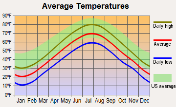
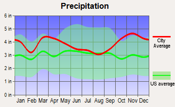
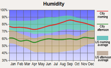
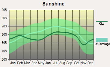
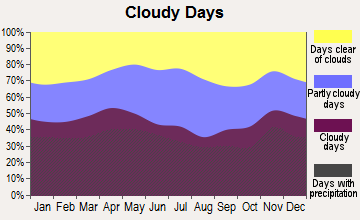
Average climate in Yarmouth, Maine
Based on data reported by over 4,000 weather stations
|
|

(lower is better)
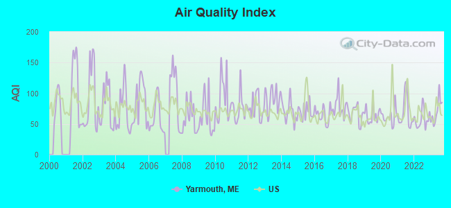
Air Quality Index (AQI) level in 2023 was 70.7. This is about average.
| City: | 70.7 |
| U.S.: | 72.6 |
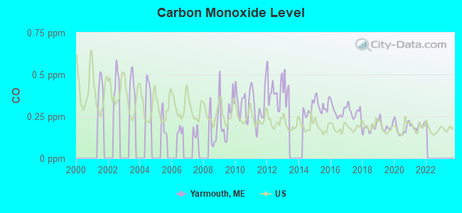
Carbon Monoxide (CO) [ppm] level in 2021 was 0.192. This is better than average. Closest monitor was 10.4 miles away from the city center.
| City: | 0.192 |
| U.S.: | 0.251 |
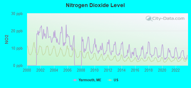
Nitrogen Dioxide (NO2) [ppb] level in 2023 was 5.47. This is about average. Closest monitor was 10.2 miles away from the city center.
| City: | 5.47 |
| U.S.: | 5.11 |
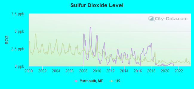
Sulfur Dioxide (SO2) [ppb] level in 2020 was 0.222. This is significantly better than average. Closest monitor was 3.2 miles away from the city center.
| City: | 0.222 |
| U.S.: | 1.515 |
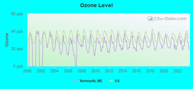
Ozone [ppb] level in 2023 was 29.1. This is about average. Closest monitor was 6.7 miles away from the city center.
| City: | 29.1 |
| U.S.: | 33.3 |
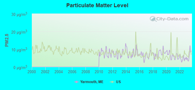
Particulate Matter (PM2.5) [µg/m3] level in 2023 was 6.44. This is better than average. Closest monitor was 9.0 miles away from the city center.
| City: | 6.44 |
| U.S.: | 8.11 |
Tornado activity:
Yarmouth-area historical tornado activity is above Maine state average. It is 80% smaller than the overall U.S. average.
On 7/8/1996, a category F2 (max. wind speeds 113-157 mph) tornado 28.9 miles away from the Yarmouth place center caused $10,000 in damages.
On 10/10/1966, a category F2 tornado 39.0 miles away from the place center caused between $5000 and $50,000 in damages.
Earthquake activity:
Yarmouth-area historical earthquake activity is significantly above Maine state average. It is 75% smaller than the overall U.S. average.On 10/16/2012 at 23:12:25, a magnitude 4.7 (4.7 ML, Depth: 10.0 mi, Class: Light, Intensity: IV - V) earthquake occurred 27.0 miles away from Yarmouth center
On 4/20/2002 at 10:50:47, a magnitude 5.3 (5.3 ML, Depth: 3.0 mi, Class: Moderate, Intensity: VI - VII) earthquake occurred 180.7 miles away from the city center
On 1/19/1982 at 00:14:42, a magnitude 4.7 (4.5 MB, 4.7 MD, 4.5 LG) earthquake occurred 73.4 miles away from the city center
On 4/20/2002 at 10:50:47, a magnitude 5.2 (5.2 MB, 4.2 MS, 5.2 MW, 5.0 MW) earthquake occurred 181.2 miles away from Yarmouth center
On 10/7/1983 at 10:18:46, a magnitude 5.3 (5.1 MB, 5.3 LG, 5.1 ML) earthquake occurred 207.1 miles away from the city center
On 2/26/1999 at 03:38:43, a magnitude 3.8 (3.8 LG, Depth: 2.0 mi, Class: Light, Intensity: II - III) earthquake occurred 57.7 miles away from the city center
Magnitude types: regional Lg-wave magnitude (LG), body-wave magnitude (MB), duration magnitude (MD), local magnitude (ML), surface-wave magnitude (MS), moment magnitude (MW)
Natural disasters:
The number of natural disasters in Cumberland County (33) is a lot greater than the US average (15).Major Disasters (Presidential) Declared: 22
Emergencies Declared: 10
Causes of natural disasters: Floods: 19, Storms: 13, Snows: 7, Winter Storms: 6, Heavy Rains: 3, Hurricanes: 3, Winds: 3, Blizzard: 1, Ice Storm: 1, Mudslide: 1, Snowfall: 1, Snowstorm: 1, Tornado: 1, Other: 2 (Note: some incidents may be assigned to more than one category).
Hospitals and medical centers in Yarmouth:
Other hospitals and medical centers near Yarmouth:
- SEDGEWOOD COMMONS (Nursing Home, about 5 miles away; FALMOUTH, ME)
- FALMOUTH BY THE SEA (Nursing Home, about 6 miles away; FALMOUTH, ME)
- FREEPORT NURSING AND REHAB CENTER (Nursing Home, about 7 miles away; FREEPORT, ME)
- ST JOSEPH'S REHABILITATION AND RESIDENCE (Nursing Home, about 9 miles away; PORTLAND, ME)
- CHS - HOSPICE (Hospital, about 9 miles away; PORTLAND, ME)
- SEASIDE REHAB AND HEALTH CARE (Nursing Home, about 10 miles away; PORTLAND, ME)
- BETTER HEALTH CARE INC (Home Health Center, about 10 miles away; PORTLAND, ME)
Colleges/universities with over 2000 students nearest to Yarmouth:
- University of Southern Maine (about 11 miles; Portland, ME; Full-time enrollment: 6,647)
- Southern Maine Community College (about 11 miles; South Portland, ME; FT enrollment: 4,666)
- Saint Joseph's College of Maine (about 15 miles; Standish, ME; FT enrollment: 2,010)
- University of New England (about 26 miles; Biddeford, ME; FT enrollment: 4,539)
- University of Maine at Augusta (about 43 miles; Augusta, ME; FT enrollment: 3,204)
- University of New Hampshire-Main Campus (about 60 miles; Durham, NH; FT enrollment: 15,243)
- University of Maine at Farmington (about 61 miles; Farmington, ME; FT enrollment: 2,036)
Public high school in Yarmouth:
- YARMOUTH HIGH SCHOOL (Location: 286 WEST ELM STREET, Grades: 9-12)
Private high school in Yarmouth:
- NORTH YARMOUTH ACADEMY (Students: 262, Location: 148 MAIN ST, Grades: 5-12)
Public elementary/middle schools in Yarmouth:
- FRANK H HARRISON MIDDLE SCHOOL (Students: 438, Location: 220 MCCARTNEY STREET, Grades: 5-8)
- WILLIAM H ROWE SCHOOL (Location: 52 SCHOOL STREET, Grades: KG-1)
- YARMOUTH ELEMENTARY SCHOOL (Location: 121 MCCARTNEY STREET, Grades: 2-4)
User-submitted facts and corrections:
- WYAR 88.3 FM in Yarmouth
Points of interest:
Notable locations in Yarmouth: Enoch Harrington House Museum (A), Maine State Information Center (B), Merrill Memorial Library (C), Yarmouth Town Hall (D), Yarmouth Historical Society and Museum (E). Display/hide their locations on the map
Churches in Yarmouth include: First Parish Congregational Church (A), First Universalist Church (B), First Baptist Church of Yarmouth (C), Saint Judes Church (D), Sacred Heart Roman Catholic Church (E), North Yarmouth and Freeport Baptist Meetinghouse (F). Display/hide their locations on the map
Reservoir: Royal River Reservoir (A). Display/hide its location on the map
Tourist attraction: Yarmouth Historical Society (Museums; 215 Main Street).
Hotels: Down-East Motel (705 Route 1), Brookside Motel (219 Route 1).
Birthplace of: Horatio Dresser - Religious leader, Samuel B. Newton - Football player and coach, Samuel Gilman Brown - Educator.
Drinking water stations with addresses in Yarmouth and their reported violations in the past:
YARMOUTH WATER DISTRICT (Population served: 7,415, Groundwater):Past health violations:VIKING VILLAGE (Population served: 107, Groundwater):
- MCL, Monthly (TCR) - In DEC-2010, Contaminant: Coliform. Follow-up actions: St Tech Assistance Visit (JAN-13-2011), St Compliance Meeting conducted (JAN-13-2011), St Boil Water Order (JAN-13-2011), St Public Notif requested (JAN-13-2011), St Formal NOV issued (JAN-13-2011), St Public Notif received (FEB-02-2011), St Compliance achieved (MAR-03-2011)
- MCL, Monthly (TCR) - In AUG-2010, Contaminant: Coliform. Follow-up actions: St Public Notif requested (AUG-23-2010), St Formal NOV issued (AUG-23-2010), St Public Notif received (SEP-14-2010), St Compliance achieved (MAR-03-2011)
- MCL, Monthly (TCR) - In SEP-2009, Contaminant: Coliform. Follow-up actions: St Public Notif received (OCT-01-2009), St Public Notif requested (OCT-26-2009), St Formal NOV issued (OCT-26-2009), St Compliance achieved (NOV-30-2009)
- MCL, Monthly (TCR) - In SEP-2008, Contaminant: Coliform. Follow-up actions: St Public Notif requested (SEP-09-2008), St Formal NOV issued (SEP-09-2008), St Public Notif received (SEP-16-2008), St Compliance achieved (JUN-05-2009)
- MCL, Monthly (TCR) - In AUG-2008, Contaminant: Coliform. Follow-up actions: St Public Notif requested (AUG-26-2008), St Formal NOV issued (AUG-26-2008), St Public Notif received (SEP-16-2008), St Compliance achieved (JUN-05-2009)
Past health violations:CHEBEAGUE ISLAND SCHOOL (Population served: 34, Groundwater):Past monitoring violations:
- MCL, Monthly (TCR) - In JUN-2014, Contaminant: Coliform. Follow-up actions: St Formal NOV issued (JUN-30-2014), St Public Notif requested (JUN-30-2014)
- MCL, Monthly (TCR) - In NOV-2013, Contaminant: Coliform. Follow-up actions: St Public Notif requested (DEC-13-2013), St Formal NOV issued (DEC-13-2013), St Compliance achieved (FEB-20-2014), St Public Notif received (MAY-16-2014)
- MCL, Monthly (TCR) - In OCT-2013, Contaminant: Coliform. Follow-up actions: St Public Notif requested (NOV-14-2013), St Formal NOV issued (NOV-14-2013), St Compliance achieved (FEB-20-2014), St Public Notif received (MAY-16-2014)
- MCL, Monthly (TCR) - In JUL-2013, Contaminant: Coliform. Follow-up actions: St Public Notif requested (AUG-02-2013), St Formal NOV issued (AUG-02-2013), St Compliance achieved (SEP-09-2013), St Public Notif received (NOV-01-2013)
- MCL, Monthly (TCR) - In OCT-2012, Contaminant: Coliform. Follow-up actions: St Public Notif requested (OCT-29-2012), St Formal NOV issued (OCT-29-2012), St Compliance achieved (MAY-24-2013), St Public Notif received (JUN-04-2013)
- MCL, Monthly (TCR) - In SEP-2012, Contaminant: Coliform. Follow-up actions: St Public Notif requested (SEP-24-2012), St Formal NOV issued (SEP-24-2012), St Compliance achieved (MAY-24-2013), St Public Notif received (JUN-04-2013)
- 2 other older health violations
- 2 routine major monitoring violations
Past monitoring violations:
- Follow-up Or Routine LCR Tap M/R - In JAN-01-2008, Contaminant: Lead and Copper Rule. Follow-up actions: St Public Notif requested (MAR-11-2008), St Formal NOV issued (MAR-11-2008), St Compliance achieved (OCT-15-2008), St Intentional no-action (JUL-22-2011)
- 23 regular monitoring violations
| This place: | 2.3 people |
| Maine: | 2.3 people |
| This place: | 61.9% |
| Whole state: | 62.9% |
| This place: | 8.3% |
| Whole state: | 9.4% |
Likely homosexual households (counted as self-reported same-sex unmarried-partner households)
- Lesbian couples: 0.4% of all households
- Gay men: 0.2% of all households
2 people in other noninstitutional facilities in 2010
103 people in nursing homes in 2000
Banks with branches in Yarmouth (2011 data):
- Bath Savings Institution: Yarmouth Branch at 424 U.S. Route One, branch established on 1996/11/18. Info updated 2006/11/03: Bank assets: $636.7 mil, Deposits: $486.8 mil, headquarters in Bath, ME, positive income, Commercial Lending Specialization, 11 total offices
- People's United Bank: Yarmouth Branch at 88 Main Street, branch established on 1995/12/18. Info updated 2012/02/16: Bank assets: $27,319.3 mil, Deposits: $20,835.4 mil, headquarters in Bridgeport, CT, positive income, Commercial Lending Specialization, 374 total offices
- KeyBank National Association: Yarmouth Branch at 188 Main Street, branch established on 1997/06/30. Info updated 2008/03/03: Bank assets: $86,198.8 mil, Deposits: $64,214.8 mil, headquarters in Cleveland, OH, positive income, Commercial Lending Specialization, 1067 total offices, Holding Company: Keycorp
- Bank of America, National Association: Yarmouth Branch at 280 Main Street, branch established on 1974/11/06. Info updated 2009/11/18: Bank assets: $1,451,969.3 mil, Deposits: $1,077,176.8 mil, headquarters in Charlotte, NC, positive income, 5782 total offices, Holding Company: Bank Of America Corporation
- TD Bank, National Association: Yarmouth Branch at Hannaford Plaza, 730 U.S. Route 1, branch established on 1967/10/02. Info updated 2010/10/04: Bank assets: $188,912.6 mil, Deposits: $153,149.8 mil, headquarters in Wilmington, DE, positive income, 1314 total offices, Holding Company: Toronto-Dominion Bank, The
- Norway Savings Bank: Yarmouth Branch at 688 Us Route 1, branch established on 2009/06/08. Info updated 2006/11/03: Bank assets: $958.8 mil, Deposits: $711.3 mil, headquarters in Norway, ME, positive income, Commercial Lending Specialization, 20 total offices, Holding Company: Norway Bancorp, Mhc
For population 15 years and over in Yarmouth:
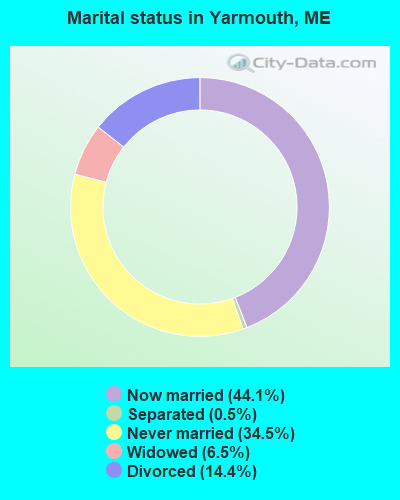
- Never married: 34.5%
- Now married: 44.1%
- Separated: 0.5%
- Widowed: 6.5%
- Divorced: 14.4%
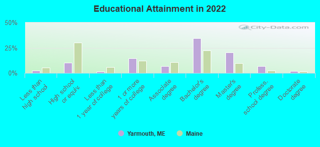
For population 25 years and over in Yarmouth:
- High school or higher: 96.9%
- Bachelor's degree or higher: 60.6%
- Graduate or professional degree: 26.6%
- Unemployed: 2.0%
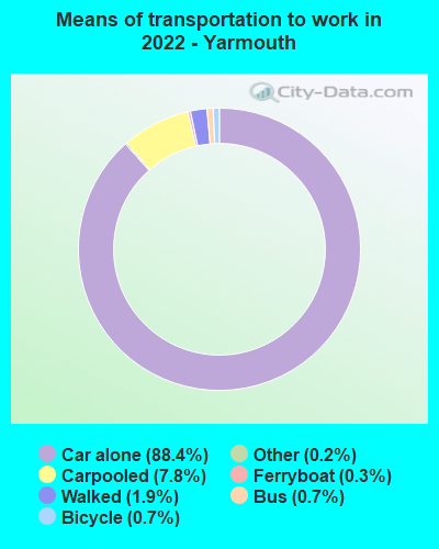
- Mean travel time to work (commute): 19.7 minutes
| Here: | 8.9 |
| Maine average: | 10.3 |

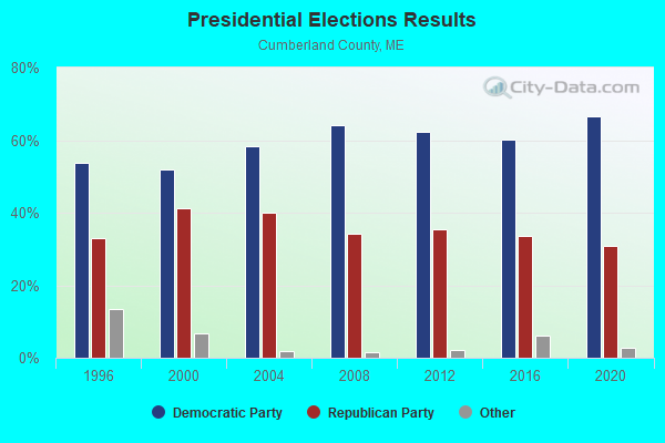
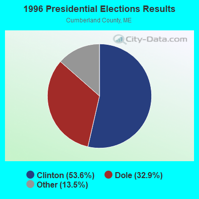
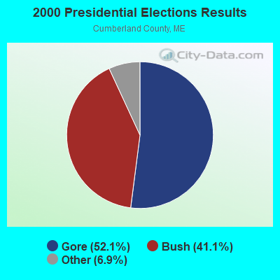
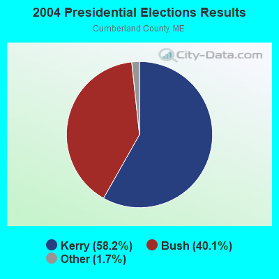

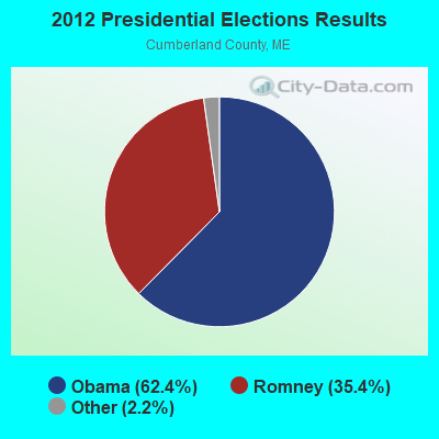
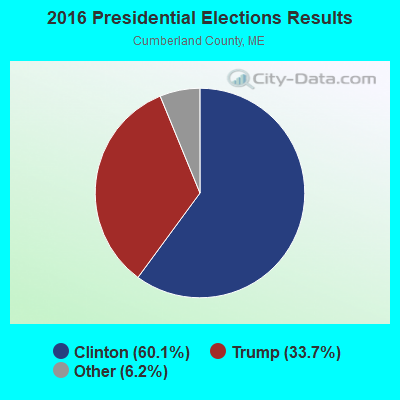

Graphs represent county-level data. Detailed 2008 Election Results
Religion statistics for Yarmouth, ME (based on Cumberland County data)
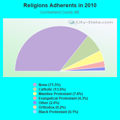
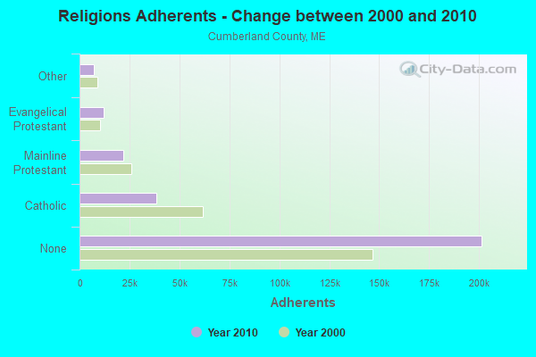
| Religion | Adherents | Congregations |
|---|---|---|
| Catholic | 38,243 | 19 |
| Mainline Protestant | 22,030 | 96 |
| Evangelical Protestant | 12,007 | 85 |
| Other | 7,187 | 44 |
| Orthodox | 500 | 1 |
| Black Protestant | 285 | 2 |
| None | 201,422 | - |
Food Environment Statistics:
| Cumberland County: | 2.62 / 10,000 pop. |
| State: | 2.80 / 10,000 pop. |
| This county: | 0.11 / 10,000 pop. |
| Maine: | 0.14 / 10,000 pop. |
| Cumberland County: | 2.44 / 10,000 pop. |
| Maine: | 2.20 / 10,000 pop. |
| This county: | 3.82 / 10,000 pop. |
| Maine: | 5.75 / 10,000 pop. |
| Cumberland County: | 12.01 / 10,000 pop. |
| Maine: | 11.02 / 10,000 pop. |
| This county: | 7.1% |
| Maine: | 8.2% |
| Here: | 19.5% |
| State: | 25.0% |
Health and Nutrition:
| Here: | 62.9% |
| Maine: | 53.9% |
| This city: | 67.1% |
| Maine: | 52.9% |
| Yarmouth: | 26.9 |
| State: | 28.3 |
| Yarmouth: | 19.0% |
| Maine: | 19.9% |
| Yarmouth: | 9.8% |
| Maine: | 8.7% |
| This city: | 7.3 |
| Maine: | 6.9 |
| Yarmouth: | 35.1% |
| State: | 34.3% |
| Yarmouth: | 68.4% |
| State: | 60.5% |
| Yarmouth: | 85.7% |
| Maine: | 79.6% |
More about Health and Nutrition of Yarmouth, ME Residents
| Businesses in Yarmouth, ME | ||||
| Name | Count | Name | Count | |
|---|---|---|---|---|
| AT&T | 1 | Goodwill | 1 | |
| Ace Hardware | 1 | H&R Block | 1 | |
| Blockbuster | 1 | MasterBrand Cabinets | 1 | |
| Circle K | 1 | McDonald's | 1 | |
| Domino's Pizza | 1 | Rite Aid | 1 | |
| Dunkin Donuts | 2 | Subway | 1 | |
| FedEx | 3 | U-Haul | 1 | |
| Ford | 1 | U.S. Cellular | 1 | |
| GNC | 1 | UPS | 2 | |
Strongest AM radio stations in Yarmouth:
- WGAN (560 AM; 5 kW; PORTLAND, ME; Owner: SAGA COMMUNICATIONS OF NEW ENGLAND, LLC)
- WLOB (1310 AM; 5 kW; PORTLAND, ME; Owner: ATLANTIC COAST RADIO, LLC)
- WMTW (870 AM; 10 kW; GORHAM, ME; Owner: RADIO PARTNERS OF MAINE, L.P.)
- WJAE (1440 AM; 5 kW; WESTBROOK, ME; Owner: ALTANTIC COAST RADIO, LLC)
- WZAN (970 AM; 5 kW; PORTLAND, ME; Owner: SAGA COMMUNICATIONS OF NEW ENGLAND, LLC)
- WLAM (1470 AM; 5 kW; LEWISTON, ME; Owner: RADIO PARTNERS OF MAINE, L.P.)
- WBAE (1490 AM; 1 kW; PORTLAND, ME; Owner: SAGA COMMUNICATIONS OF NEW ENGLAND, LLC)
- WRKO (680 AM; 50 kW; BOSTON, MA; Owner: ENTERCOM BOSTON LICENSE, LLC)
- WJJB (900 AM; 1 kW; BRUNSWICK, ME; Owner: ATLANTIC COAST RADIO, LLC)
- WTME (780 AM; 10 kW; RUMFORD, ME; Owner: MOUNTAIN VALLEY BROADCASTING, INC.)
- WEEI (850 AM; 50 kW; BOSTON, MA; Owner: ENTERCOM BOSTON LICENSE, LLC)
- WJTO (730 AM; 1 kW; BATH, ME; Owner: BLUE JEY BROADCASTING COMPANY)
- WBZ (1030 AM; 50 kW; BOSTON, MA; Owner: INFINITY BROADCASTING OPERATIONS, INC.)
Strongest FM radio stations in Yarmouth:
- WJBQ (97.9 FM; PORTLAND, ME; Owner: CITADEL BROADCASTING COMPANY)
- WPOR (101.9 FM; PORTLAND, ME; Owner: SAGA COMMUNICATIONS OF NEW ENGLAND, LLC)
- WMTW-FM (106.7 FM; NORTH WINDHAM, ME; Owner: RADIO PARTNERS OF MAINE, L.P.)
- WMSJ (89.3 FM; FREEPORT, ME; Owner: DOWNEAST CHRISTIAN COMMUNICATIONS)
- WTHT (107.5 FM; LEWISTON, ME; Owner: RADIO PARTNERS OF MAINE, L.P.)
- WBLM (102.9 FM; PORTLAND, ME; Owner: CITADEL BROADCASTING COMPANY)
- WMGX (93.1 FM; PORTLAND, ME; Owner: SAGA COMMUNICATIONS OF NEW ENGLAND, LLC)
- WMEA (90.1 FM; PORTLAND, ME; Owner: MAINE PUBLIC BROADCASTING CORPORATION)
- WMEK-FM (99.9 FM; AUBURN, ME; Owner: RADIO PARTNERS OF MAINE, L.P.)
- WYNZ (100.9 FM; WESTBROOK, ME; Owner: SAGA COMMUNICATIONS OF NEW ENGLAND, LLC)
- WJJB-FM (95.5 FM; TOPSHAM, ME; Owner: ATLANTIC COAST RADIO, LLC)
- WCLZ (98.9 FM; BRUNSWICK, ME; Owner: CITADEL BROADCASTING COMPANY)
- WPKQ (103.7 FM; NORTH CONWAY, NH; Owner: CITADEL BROADCASTING COMPANY)
- WHOM (94.9 FM; MT. WASHINGTON, NH; Owner: CITADEL BROADCASTING COMPANY)
- WYFP (91.9 FM; HARPSWELL, ME; Owner: BIBLE BROADCASTING NETWORK, INC.)
- WSCY (106.9 FM; MOULTONBOROUGH, NH; Owner: NORTHEAST COMMUNICATIONS CORPORATION)
- W245AA (96.9 FM; PORTLAND, ME; Owner: RADIO PARTNERS OF MAINE, L.P.)
- WCYI (93.9 FM; LEWISTON, ME; Owner: CITADEL BROADCASTING COMPANY)
- WCYY (94.3 FM; BIDDEFORD, ME; Owner: CITADEL BROADCASTING COMPANY)
- WRED (95.9 FM; SACO, ME; Owner: ATLANTIC COAST RADIO, LLC)
TV broadcast stations around Yarmouth:
- WPXT (Channel 51; PORTLAND, ME; Owner: HMW, INC.)
- WPME (Channel 35; LEWISTON, ME; Owner: KB PRIME MEDIA LLC)
- WGME-TV (Channel 13; PORTLAND, ME; Owner: WGME LICENSEE, LLC)
- W32CA (Channel 32; PORTLAND, ME; Owner: NATIONAL MINORITY T.V., INC.)
- WMTW-TV (Channel 8; POLAND SPRING, ME; Owner: WMTW BROADCAST GROUP, LLC)
- W58CM (Channel 58; BANGOR, ME; Owner: MS COMMUNICATIONS, LLC)
- WCSH (Channel 6; PORTLAND, ME; Owner: PACIFIC AND SOUTHERN COMPANY, INC.)
- W57AP (Channel 57; FALMOUTH, ME; Owner: SHERWOOD H. CRAIG)
- WMEA-TV (Channel 26; BIDDEFORD, ME; Owner: MAINE PUBLIC BROADCASTING CORP.)
- WPFO (Channel 23; WATERVILLE, ME; Owner: CMCG PORTLAND LICENSE LLC)
- WLLB-LP (Channel 15; PORTLAND, ME; Owner: CARTER BROADCASTING CORPORATION)
- WCBB (Channel 10; AUGUSTA, ME; Owner: MAINE PUBLIC BROADCASTING CORP.)
- National Bridge Inventory (NBI) Statistics
- 16Number of bridges
- 249ft / 76.0mTotal length
- 193,179Total average daily traffic
- 16,170Total average daily truck traffic
- 268,069Total future (year 2036) average daily traffic
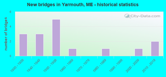
- New bridges - historical statistics
- 31930-1939
- 31940-1949
- 51950-1959
- 11960-1969
- 11980-1989
- 12000-2009
- 22010-2019
FCC Registered Cell Phone Towers:
1- Drinkwater Point Rd (Lat: 43.779028 Lon: -70.158444), Type: Upole, Structure height: 42.4 m, Overall height: 43 m, Call Sign: KNKA708
Assigned Frequencies: 869.040 MHz, 869.040 MHz, 869.040 MHz, 824.040 MHz, 824.040 MHz, 824.040 MHz, 890.010 MHz, 890.010 MHz, 890.010 MHz, 845.010 MHz, 845.010 MHz, 845.010 MHzGrant Date: 08/29/2017, Expiration Date: 10/01/2027, Certifier: Michael P GogginRegistrant: At&t Services, Inc., 208 S Akard St, 20f, Dallas, TX 75202, Phone: (855) 699-7073, Fax: (202) 457-3073, Email:
FCC Registered Antenna Towers:
3- Peter M Connolly, 178 North Road (Lat: 43.811472 Lon: -70.179750), Type: 47.2, Overall height: 39.6 m, Registrant: Holland & Knight L.L.P., Pconnolly@hklaw.Com, , Washi-ngton, Phone: (202) 862-5989
- Peter M Connolly, 178 North Road (Lat: 43.811472 Lon: -70.179750), Type: 47.2, Overall height: 39.6 m, Registrant: Holland & Knight L.L.P., Pconnolly@hklaw.Com, , Washi-ngton, Phone: (202) 862-5989
- Cayla Gamble, 178 North Road (Lat: 43.811472 Lon: -70.179750), Type: 47.2, Structure height: 23005 m, Overall height: 39.6 m, Registrant: Wilkinson Barker Knauer, LLP, Gwerner@wbklaw.Com, , Washi-ngton, Phone: (202) 383-3420
FCC Registered Broadcast Land Mobile Towers:
12 (See the full list of FCC Registered Broadcast Land Mobile Towers in Yarmouth, ME)FCC Registered Microwave Towers:
1- WYMAN STN, W F Wyman Generating Stn Birch Pt Cousins Island (Lat: 43.750778 Lon: -70.155972), Type: Building, Structure height: 98.8 m, Call Sign: KBY75,
Assigned Frequencies: 6675.00 MHz, Grant Date: 07/10/2018, Expiration Date: 07/30/2028, Registrant: Utc Spectrum Services, 1129 20th St Nw, Suite 350, Washington, DC 20036, Phone: (202) 872-0030, Fax: (202) 872-1331, Email:
FCC Registered Paging Towers:
1- Us Route One (Lat: 43.792556 Lon: -70.189194), Call Sign: KNKB960,
Assigned Frequencies: 35.2400 MHz, Expiration Date: 04/01/1999, Cancellation Date: 06/05/1999, Registrant: Landcomm, Inc., 4 Fundy Road, Portland, ME 04105
FCC Registered Maritime Coast & Aviation Ground Towers:
5- 1 Evergreen Dr (Lat: 43.791750 Lon: -70.178944), Type: Building, Overall height: 8 m, Call Sign: KGW339,
Assigned Frequencies: 156.450 MHz, 4.12640 MHz, 156.500 MHz, 4.15040 MHz, 156.525 MHz, 6.23140 MHz, 156.800 MHz, 8.29840 MHz, 156.925 MHz, 12.3604 MHz, 16.5354 MHz, 22.1724 MHz, Grant Date: 08/16/1994, Expiration Date: 08/16/1999, Cancellation Date: 05/06/2001, Registrant: Charter Yachts Ltd, 1 Evergreen Dr, Yarmouth, ME 04096
- 722 Lafayette St Marina Store Office (Lat: 43.784806 Lon: -70.167278), Type: Building, Overall height: 6 m, Call Sign: KYZ426,
Assigned Frequencies: 156.450 MHz, 156.800 MHz, Grant Date: 04/22/1999, Expiration Date: 04/22/2004, Cancellation Date: 06/27/2004, Registrant: Yarmouth Boat Yard Inc, 72 Lafayette St, Yarmouth, ME 04096
- William F Wyman Station Cousins Island (Lat: 43.750361 Lon: -70.156722), Type: Building, Overall height: 4 m, Call Sign: WHU870,
Assigned Frequencies: 156.450 MHz, 156.500 MHz, 156.800 MHz, Grant Date: 07/14/1999, Expiration Date: 09/22/2004, Cancellation Date: 11/27/2004, Registrant: Fpl Energy Maine, 100 Middle St, Portland, ME 04101
- 315a Cousins Island Rd (Lat: 43.765917 Lon: -70.135611), Type: Building, Overall height: 6 m, Call Sign: WHW957, Licensee ID: L00001341,
Assigned Frequencies: 156.450 MHz, 156.800 MHz, 156.950 MHz, Grant Date: 03/29/1994, Expiration Date: 03/29/1999, Cancellation Date: 05/06/2001, Registrant: Chebeague Transportation Company, 315a Cousins Island Rd, Yarmouth, ME 04096
- Lower Falls Landing 142 Lafayette St (Lat: 43.795639 Lon: -70.172556), Type: Building, Overall height: 5 m, Call Sign: WHW967,
Assigned Frequencies: 156.425 MHz, 156.450 MHz, 156.800 MHz, Grant Date: 01/25/2024, Expiration Date: 03/04/2034, Registrant: Yankee Marina Inc., 142 Lafayette Street, Yarmouth, ME 04096, Phone: (207) 846-4326, Fax: (207) 846-3629, Email:
FCC Registered Amateur Radio Licenses:
116 (See the full list of FCC Registered Amateur Radio Licenses in Yarmouth)FAA Registered Aircraft:
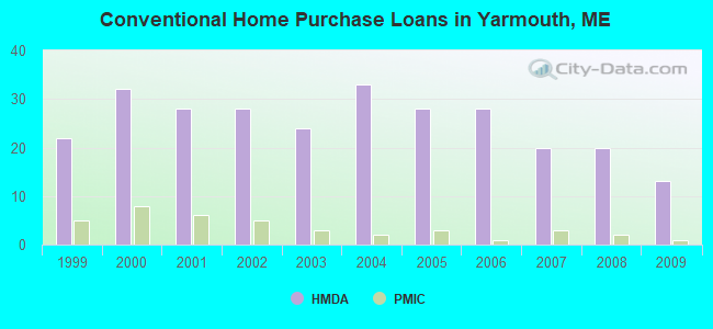
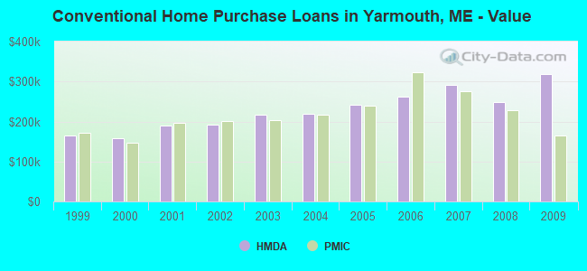
9 (See the full list of FAA Registered Aircraft in Yarmouth)| Home Mortgage Disclosure Act Aggregated Statistics For Year 2009 (Based on 2 partial tracts) | ||||||||||
| A) FHA, FSA/RHS & VA Home Purchase Loans | B) Conventional Home Purchase Loans | C) Refinancings | D) Home Improvement Loans | F) Non-occupant Loans on < 5 Family Dwellings (A B C & D) | ||||||
|---|---|---|---|---|---|---|---|---|---|---|
| Number | Average Value | Number | Average Value | Number | Average Value | Number | Average Value | Number | Average Value | |
| LOANS ORIGINATED | 3 | $245,430 | 13 | $319,024 | 74 | $239,426 | 6 | $78,880 | 4 | $257,560 |
| APPLICATIONS APPROVED, NOT ACCEPTED | 0 | $0 | 1 | $530,360 | 8 | $244,784 | 1 | $10,420 | 0 | $0 |
| APPLICATIONS DENIED | 0 | $0 | 1 | $238,190 | 15 | $273,386 | 1 | $191,910 | 0 | $0 |
| APPLICATIONS WITHDRAWN | 0 | $0 | 1 | $294,220 | 8 | $250,689 | 0 | $0 | 1 | $80,260 |
| FILES CLOSED FOR INCOMPLETENESS | 0 | $0 | 0 | $0 | 2 | $231,345 | 0 | $0 | 0 | $0 |
Detailed HMDA statistics for the following Tracts: 0044.01 , 0044.02
| Private Mortgage Insurance Companies Aggregated Statistics For Year 2009 (Based on 2 partial tracts) | ||||
| A) Conventional Home Purchase Loans | B) Refinancings | |||
|---|---|---|---|---|
| Number | Average Value | Number | Average Value | |
| LOANS ORIGINATED | 1 | $164,180 | 1 | $235,840 |
| APPLICATIONS APPROVED, NOT ACCEPTED | 1 | $125,680 | 0 | $0 |
| APPLICATIONS DENIED | 0 | $0 | 1 | $121,700 |
| APPLICATIONS WITHDRAWN | 0 | $0 | 0 | $0 |
| FILES CLOSED FOR INCOMPLETENESS | 0 | $0 | 0 | $0 |
Detailed PMIC statistics for the following Tracts: 0044.01 , 0044.02
2003 - 2018 National Fire Incident Reporting System (NFIRS) incidents
- Fire incident types reported to NFIRS in Yarmouth, ME
- 9853.3%Structure Fires
- 5328.8%Outside Fires
- 2614.1%Mobile Property/Vehicle Fires
- 73.8%Other
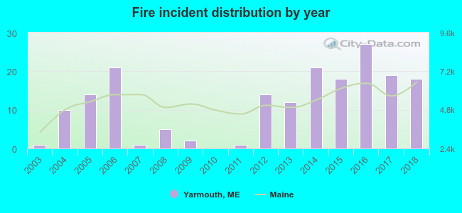 According to the data from the years 2003 - 2018 the average number of fires per year is 12. The highest number of fires - 27 took place in 2016, and the least - 0 in 2010. The data has a growing trend.
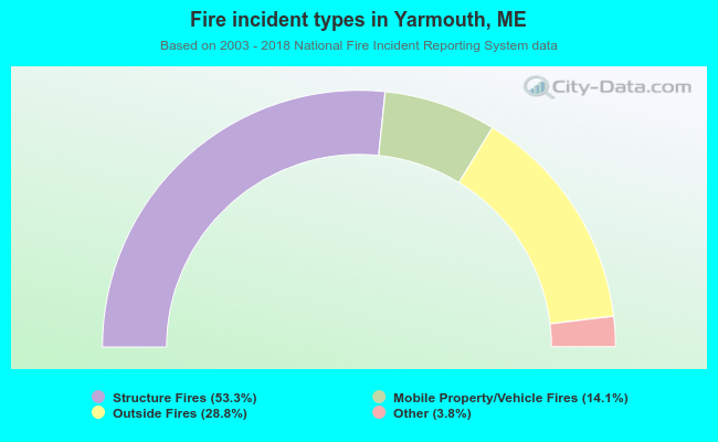 When looking into fire subcategories, the most reports belonged to: Structure Fires (53.3%), and Outside Fires (28.8%).
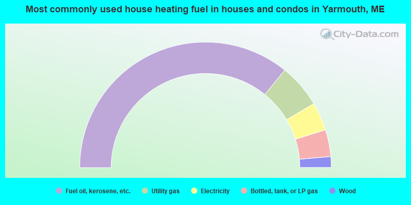
- 71.7%Fuel oil, kerosene, etc.
- 11.3%Utility gas
- 7.3%Electricity
- 6.9%Bottled, tank, or LP gas
- 2.8%Wood
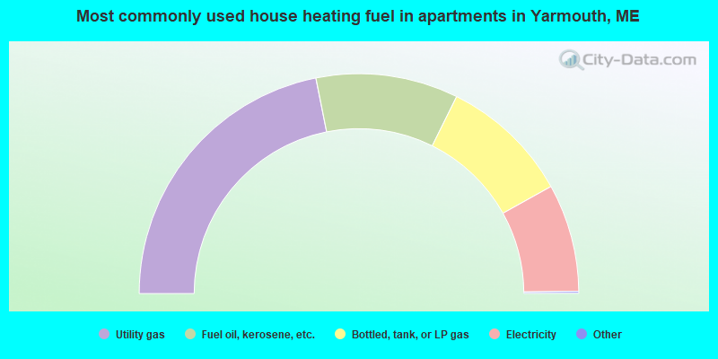
- 43.8%Utility gas
- 21.0%Fuel oil, kerosene, etc.
- 19.2%Bottled, tank, or LP gas
- 15.9%Electricity
Yarmouth compared to Maine state average:
- Median house value above state average.
- Unemployed percentage significantly below state average.
- Hispanic race population percentage above state average.
- Foreign-born population percentage above state average.
- Length of stay since moving in significantly below state average.
- Number of college students above state average.
- Percentage of population with a bachelor's degree or higher significantly above state average.
Yarmouth on our top lists:
- #38 on the list of "Top 101 cities with largest percentage of males in industries: management of companies and enterprises (population 5,000+)"
- #51 on the list of "Top 101 cities with largest percentage of males in industries: health care and social assistance (population 5,000+)"
- #53 on the list of "Top 101 cities with largest percentage of males in occupations: health diagnosing and treating practitioners and other technical occupations (population 5,000+)"
- #101 on the list of "Top 101 cities with the highest cost per building permit(population 5,000+)"
- #28 on the list of "Top 101 counties with the highest percentage of residents that exercised in the past month"
- #30 on the list of "Top 101 counties with the best general health status score of residents (1-5), 3 years of data"
- #40 on the list of "Top 101 counties with the highest percentage of residents that visited a dentist within the past year"
- #43 on the list of "Top 101 counties with the highest Nitrogen Dioxide air pollution readings in 2012 (ppm)"
- #49 on the list of "Top 101 counties with the lowest number of births per 1000 residents 2007-2013"

|
|
Total of 52 patent applications in 2008-2024.