Zuni-Ramah Navajo, New Mexico
Submit your own pictures of this place and show them to the world
- OSM Map
- Google Map
- MSN Map
| Males: 1,210 | |
| Females: 1,275 |
| Median resident age: | 28.7 years |
| New Mexico median age: | 34.6 years |
Zip code: 87321
| Zuni-Ramah Navajo: | $39,946 |
| NM: | $59,726 |
Estimated per capita income in 2022: $17,433 (it was $8,796 in 2000)
Zuni-Ramah Navajo CCD income, earnings, and wages data
Estimated median house or condo value in 2022: $64,932 (it was $30,800 in 2000)
| Zuni-Ramah Navajo: | $64,932 |
| NM: | $243,100 |
Zuni-Ramah Navajo, NM residents, houses, and apartments details
Detailed information about poverty and poor residents in Zuni-Ramah Navajo, NM
Compare current foreclosures near your location:
| Photo | Address | Area | Beds / Baths | Price | Details |
|---|---|---|---|---|---|

|
#1
S High St
Columbus, OH 43207
|
1,678 sq. feet
|
2 baths 4 beds |
$31,900
|
show details |

|
#2
Bayberry Cir
Columbus, OH 43207
|
1,564 sq. feet
|
1 baths 3 beds |
$127,500
|
show details |

|
#3
E 21st Ave
Columbus, OH 43211
|
1,061 sq. feet
|
1 baths 3 beds |
$187,900
|
show details |

|
#4
Meadowbrook Dr
Columbus, OH 43207
|
1,752 sq. feet
|
2 baths 4 beds |
show details | |

|
#5
Bretton Pl
Columbus, OH 43211
|
1,056 sq. feet
|
1 baths 3 beds |
show details | |

|
#6
S Richardson Ave
Columbus, OH 43204
|
1,520 sq. feet
|
2 baths 3 beds |
show details | |

|
#7
Fergus Rd
Grove City, OH 43123
|
3,312 sq. feet
|
2 baths 4 beds |
show details | |

|
#8
High Free Pike
West Jefferson, OH 43162
|
1,216 sq. feet
|
2 baths 4 beds |
show details | |

|
#9
S Chillicothe St
Plain City, OH 43064
|
1,736 sq. feet
|
2 baths 4 beds |
show details | |

|
#10
Kingsglen Dr
Grove City, OH 43123
|
1,635 sq. feet
|
2 baths 4 beds |
show details |
| Photo | Address | Area | Beds / Baths | Price | Details |
|---|---|---|---|---|---|

|
#11
Derrer Rd -872
Columbus, OH 43204
|
1,667 sq. feet
|
2 baths 5 beds |
show details | |

|
#12
Mink St SW
Pataskala, OH 43062
|
1,442 sq. feet
|
1 baths 3 beds |
show details | |

|
#13
Hiawatha Park Dr
Columbus, OH 43211
|
1,278 sq. feet
|
1 baths 4 beds |
show details | |

|
#14
Rosewood Ct
Powell, OH 43065
|
2,801 sq. feet
|
3 baths 4 beds |
show details | |

|
#15
Ferris Rd
Columbus, OH 43224
|
2,218 sq. feet
|
3 baths 3 beds |
show details | |

|
#16
N Roys Ave
Columbus, OH 43204
|
1,248 sq. feet
|
2 baths 3 beds |
show details | |

|
#17
Falls Peak Ln
Delaware, OH 43015
|
1,352 sq. feet
|
2 baths 2 beds |
show details | |

|
#18
Midland Ave
Columbus, OH 43223
|
1,518 sq. feet
|
1 baths 2 beds |
show details | |

|
#19
Elaine Rd
Columbus, OH 43213
|
764 sq. feet
|
1 baths 2 beds |
show details | |

|
#20
Vineyard Haven Loop
Dublin, OH 43016
|
4,625 sq. feet
|
4 baths 4 beds |
show details |
| Photo | Address | Area | Beds / Baths | Price | Details |
|---|---|---|---|---|---|

|
#21
Wrexham Ave
Columbus, OH 43223
|
1,235 sq. feet
|
1 baths 3 beds |
show details | |

|
#22
Bunch Flower Ct
Westerville, OH 43082
|
3,173 sq. feet
|
2 baths 4 beds |
show details | |

|
#23
Mayflower Blvd
Columbus, OH 43213
|
1,591 sq. feet
|
2 baths 4 beds |
show details | |

|
#24
S Hague Ave
Columbus, OH 43204
|
979 sq. feet
|
1 baths 2 beds |
show details | |

|
#25
Arborlee Dr
Reynoldsburg, OH 43068
|
1,263 sq. feet
|
2 baths 3 beds |
show details | |

|
#26
Brookstone Dr
Westerville, OH 43082
|
1,783 sq. feet
|
3 baths 3 beds |
show details | |

|
#27
N Grener Ave
Columbus, OH 43228
|
1,120 sq. feet
|
1 baths 3 beds |
show details | |

|
#28
Bernadette Rd
Columbus, OH 43204
|
1,168 sq. feet
|
1 baths 3 beds |
show details | |

|
#29
Sleeping Meadow Dr
New Albany, OH 43054
|
3,211 sq. feet
|
2 baths 4 beds |
show details | |

|
#30
Belle Oak Dr
Galloway, OH 43119
|
1,296 sq. feet
|
2 baths 3 beds |
show details |
| Photo | Address | Area | Beds / Baths | Price | Details |
|---|---|---|---|---|---|

|
#31
Scottwood Rd
Columbus, OH 43227
|
1,008 sq. feet
|
1 baths 3 beds |
show details | |

|
#32
Fahlander Dr N
Columbus, OH 43229
|
1,338 sq. feet
|
2 baths 3 beds |
show details | |

|
#33
Stoneybrook Blvd # 21a
Hilliard, OH 43026
|
1,231 sq. feet
|
2 baths 3 beds |
show details | |

|
#34
Marshrun Dr
Grove City, OH 43123
|
2,036 sq. feet
|
2 baths 4 beds |
show details | |

|
#35
Spohn Dr
Westerville, OH 43081
|
1,040 sq. feet
|
1 baths 3 beds |
show details | |

|
#36
E Kanawha Ave
Columbus, OH 43214
|
1,230 sq. feet
|
1 baths 3 beds |
show details | |

|
#37
Oreily Dr
Galloway, OH 43119
|
1,533 sq. feet
|
2 baths 3 beds |
show details | |

|
#38
Pendent Ln
Columbus, OH 43207
|
1,260 sq. feet
|
2 baths 3 beds |
show details | |

|
#39
Conway Dr
Columbus, OH 43227
|
1,232 sq. feet
|
1 baths 3 beds |
show details | |

|
#40
Barthel Ave
Columbus, OH 43227
|
1,276 sq. feet
|
1 baths 3 beds |
show details |
| Photo | Address | Area | Beds / Baths | Price | Details |
|---|---|---|---|---|---|

|
#41
Ridgebury Dr
Hilliard, OH 43026
|
832 sq. feet
|
1 baths 2 beds |
show details | |

|
#42
Sandpiper Dr
Orient, OH 43146
|
2,219 sq. feet
|
2 baths 4 beds |
show details | |

|
#43
Leap Rd
Hilliard, OH 43026
|
1,352 sq. feet
|
1 baths 3 beds |
show details | |

|
#44
Messner Dr
Hilliard, OH 43026
|
832 sq. feet
|
1 baths 2 beds |
show details | |

|
#45
Illinois Ave
Westerville, OH 43081
|
1,120 sq. feet
|
1 baths 3 beds |
show details | |

|
#46
Mango Ln
Hilliard, OH 43026
|
1,024 sq. feet
|
1 baths 2 beds |
show details | |

|
#47
Tea Party Pl
Columbus, OH 43207
|
1,176 sq. feet
|
2 baths 3 beds |
show details | |

|
#48
Maroon Dr
Powell, OH 43065
|
1,198 sq. feet
|
2 baths 3 beds |
show details | |

|
#49
Windy Hill Ln
Galloway, OH 43119
|
1,108 sq. feet
|
2 baths 3 beds |
show details | |

|
Check over 1 million property listings on Foreclosure.com!
|
browse all offers | |||

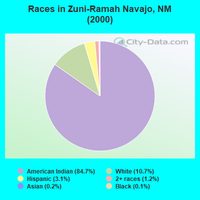
- 1,98584.7%American Indian alone
- 25010.7%White alone
- 723.1%Hispanic
- 281.2%Two or more races
- 50.2%Asian alone
- 30.1%Black alone
Races in Zuni-Ramah Navajo detailed stats: ancestries, foreign born residents, place of birth
 Recent articles from our blog. Our writers, many of them Ph.D. graduates or candidates, create easy-to-read articles on a wide variety of topics.
Current Local Time: MST time zone
Land area: 477.1 square miles.
Population density: 5.2 people per square mile (very low).
| Zuni-Ramah Navajo CCD: | 0.6% ($199) |
| New Mexico: | 0.7% ($699) |
Nearest city with pop. 50,000+: Rio Rancho, NM  (102.5 miles , pop. 51,765).
Nearest city with pop. 200,000+: Albuquerque, NM (103.7 miles , pop. 448,607).
Nearest city with pop. 1,000,000+: Phoenix, AZ (229.9 miles , pop. 1,321,045).
Nearest cities:
), ), )Latitude: 34.92 N, Longitude: 108.43 W
Area code commonly used in this area: 505
| Here: | 4.9% |
| New Mexico: | 3.6% |
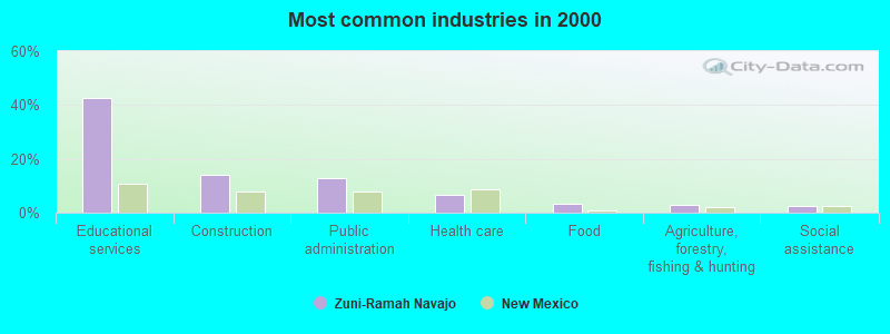
- Educational services (42.7%)
- Construction (14.1%)
- Public administration (12.7%)
- Health care (6.5%)
- Food (3.4%)
- Agriculture, forestry, fishing & hunting (2.8%)
- Social assistance (2.7%)
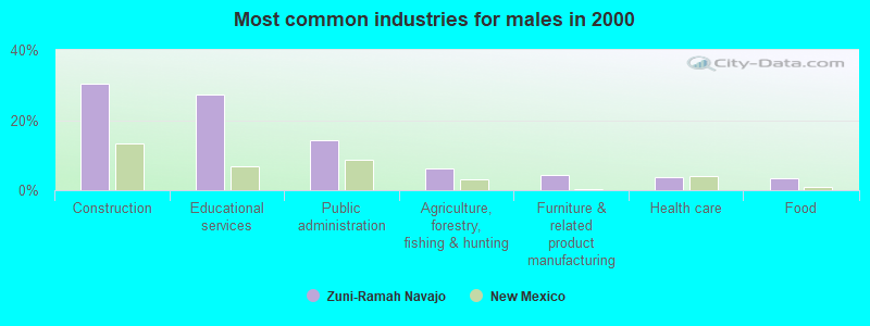
- Construction (30.4%)
- Educational services (27.2%)
- Public administration (14.1%)
- Agriculture, forestry, fishing & hunting (6.2%)
- Furniture & related product manufacturing (4.3%)
- Health care (3.6%)
- Food (3.3%)
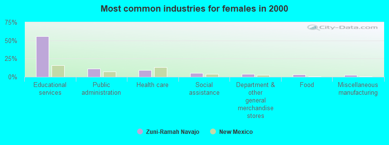
- Educational services (56.1%)
- Public administration (11.5%)
- Health care (9.0%)
- Social assistance (5.0%)
- Department & other general merchandise stores (4.0%)
- Food (3.4%)
- Miscellaneous manufacturing (2.8%)
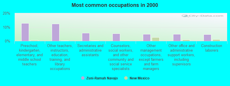
- Preschool, kindergarten, elementary, and middle school teachers (12.7%)
- Other teachers, instructors, education, training, and library occupations (12.4%)
- Secretaries and administrative assistants (5.9%)
- Counselors, social workers, and other community and social service specialists (5.4%)
- Other management occupations, except farmers and farm managers (5.0%)
- Other office and administrative support workers, including supervisors (4.9%)
- Construction laborers (4.7%)
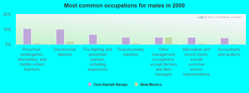
- Preschool, kindergarten, elementary, and middle school teachers (10.5%)
- Construction laborers (10.1%)
- Fire fighting and prevention workers, including supervisors (6.5%)
- Postsecondary teachers (4.7%)
- Other management occupations, except farmers and farm managers (4.7%)
- Information and record clerks, except customer service representatives (4.7%)
- Accountants and auditors (4.3%)
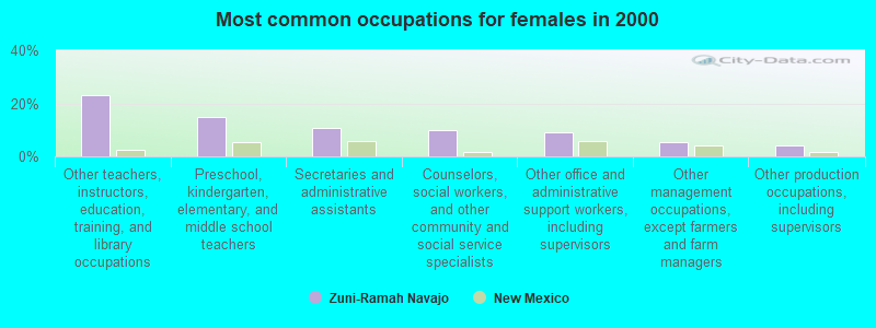
- Other teachers, instructors, education, training, and library occupations (23.1%)
- Preschool, kindergarten, elementary, and middle school teachers (14.6%)
- Secretaries and administrative assistants (10.9%)
- Counselors, social workers, and other community and social service specialists (10.0%)
- Other office and administrative support workers, including supervisors (9.0%)
- Other management occupations, except farmers and farm managers (5.3%)
- Other production occupations, including supervisors (4.0%)
Average climate in Zuni-Ramah Navajo, New Mexico
Based on data reported by over 4,000 weather stations


Earthquake activity:
Zuni-Ramah Navajo-area historical earthquake activity is significantly above New Mexico state average. It is 1046% greater than the overall U.S. average.On 6/28/1992 at 11:57:34, a magnitude 7.6 (6.2 MB, 7.6 MS, 7.3 MW, Depth: 0.7 mi, Class: Major, Intensity: VIII - XII) earthquake occurred 464.4 miles away from the city center, causing 3 deaths (1 shaking deaths, 2 other deaths) and 400 injuries, causing $100,000,000 total damage and $40,000,000 insured losses
On 10/16/1999 at 09:46:44, a magnitude 7.4 (6.3 MB, 7.4 MS, 7.2 MW, 7.3 ML) earthquake occurred 456.1 miles away from the city center
On 5/19/1940 at 04:36:40, a magnitude 7.2 (7.2 UK) earthquake occurred 432.7 miles away from the city center, causing $33,000,000 total damage
On 12/31/1934 at 18:45:56, a magnitude 7.1 (7.1 UK) earthquake occurred 448.9 miles away from Zuni-Ramah Navajo center
On 10/15/1979 at 23:16:54, a magnitude 7.0 (5.7 MB, 6.9 MS, 7.0 ML, 6.4 MW) earthquake occurred 439.0 miles away from Zuni-Ramah Navajo center
On 6/29/2014 at 04:59:35, a magnitude 5.3 (5.3 MW, Depth: 4.0 mi, Class: Moderate, Intensity: VI - VII) earthquake occurred 167.2 miles away from Zuni-Ramah Navajo center
Magnitude types: body-wave magnitude (MB), local magnitude (ML), surface-wave magnitude (MS), moment magnitude (MW)
Natural disasters:
The number of natural disasters in Cibola County (8) is smaller than the US average (15).Major Disasters (Presidential) Declared: 5
Emergencies Declared: 2
Causes of natural disasters: Floods: 4, Storms: 3, Fires: 2, Hurricane: 1, Mudslide: 1, Other: 1 (Note: some incidents may be assigned to more than one category).
Colleges/universities with over 2000 students nearest to Zuni-Ramah Navajo:
- Central New Mexico Community College (about 103 miles; Albuquerque, NM; Full-time enrollment: 19,398)
- University of New Mexico-Main Campus (about 103 miles; Albuquerque, NM; FT enrollment: 23,042)
- University of Phoenix-Albuquerque Campus (about 106 miles; Albuquerque, NM; FT enrollment: 2,335)
- San Juan College (about 129 miles; Farmington, NM; FT enrollment: 5,112)
- Santa Fe Community College (about 145 miles; Santa Fe, NM; FT enrollment: 3,047)
- Western New Mexico University (about 149 miles; Silver City, NM; FT enrollment: 2,456)
- Eastern Arizona College (about 163 miles; Thatcher, AZ; FT enrollment: 3,810)
Points of interest:
Notable locations in Zuni-Ramah Navajo: Ojo Pueblo (A), Ojo Pueblo Windmill (B), Ramah Navajo Community Center (C), ECW Number 7 Windmill (D), RWPZ Number 25 Windmill (E), Candy Kitchen (F), Inscription Rock (G), Jaralosa Pueblo Historic Site (H), Hinkson Ranch Pueblo Historic Site (I), Atsinna (J), El Morro Weather Station (K), Candy Kitchen Volunteer Fire Department / Emergency Medical Services Station 2 (L), Pinehill Emergency Medical Services (M), Pinehill Volunteer Fire Department (N), Candy Kitchen Volunteer Fire Department / Emergency Medical Services Station 1 Headquarters (O). Display/hide their locations on the map
Churches in Zuni-Ramah Navajo include: Morman Church (A), Red Lake Mission (B), Nazarene Church (C). Display/hide their locations on the map
Cemetery: El Morro Cemetery (1). Display/hide its location on the map
Lakes and reservoirs: Sokno Lake (A), Pig-a-be-ikiti (B), Nicoll Lake (C), Laguna Colorada (D), Laguna Concho (E), Dog Lake (F), Laguna Flora (G), Upper Galestina Number 7 Reservoir (H). Display/hide their locations on the map
Streams, rivers, and creeks: Plumasano Wash (A), Willow Wash (B). Display/hide their locations on the map
Parks in Zuni-Ramah Navajo include: El Morro National Monument (1), El Morro National Monument Inscription Rock Historical Marker (2), Pueblo Revolt Tricentennial Historical Marker (3), Lava Beds Historical Marker (4). Display/hide their locations on the map
| This place: | 2.9 people |
| New Mexico: | 2.5 people |
| This place: | 67.7% |
| Whole state: | 65.5% |
| This place: | 10.8% |
| Whole state: | 8.2% |
Likely homosexual households (counted as self-reported same-sex unmarried-partner households)
- Lesbian couples: 0.4% of all households
- Gay men: 0.4% of all households
| This place: | 32.3% |
| Whole state: | 18.4% |
| This place: | 17.9% |
| Whole state: | 7.8% |
For population 15 years and over in Zuni-Ramah Navajo:
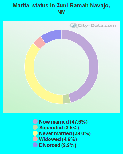
- Never married: 38.0%
- Now married: 47.6%
- Separated: 3.5%
- Widowed: 4.6%
- Divorced: 9.9%
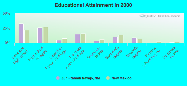
For population 25 years and over in Zuni-Ramah Navajo:
- High school or higher: 67.7%
- Bachelor's degree or higher: 19.4%
- Graduate or professional degree: 9.4%
- Unemployed: 17.9%
- Mean travel time to work (commute): 21.5 minutes
| Here: | 22.1 |
| New Mexico average: | 14.5 |
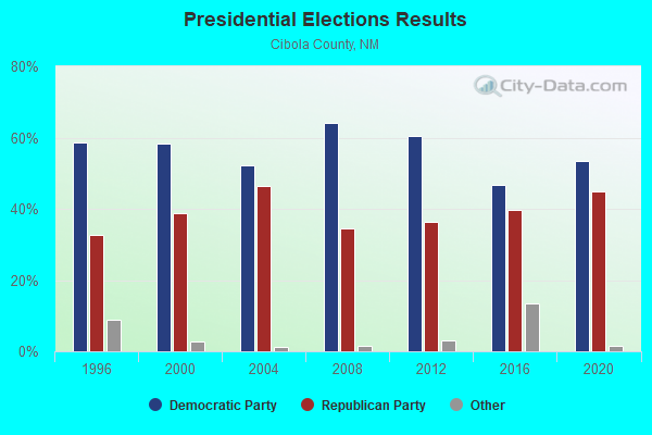
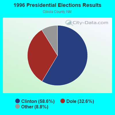

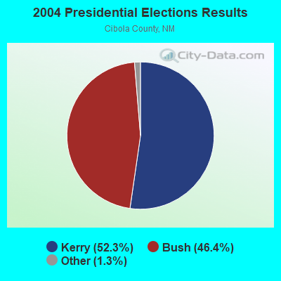
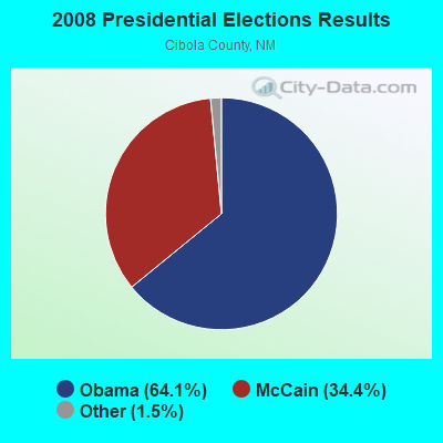
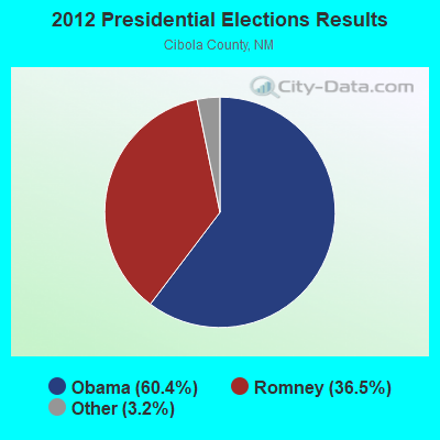
Graphs represent county-level data. Detailed 2008 Election Results
Religion statistics for Zuni-Ramah Navajo, NM (based on Cibola County data)
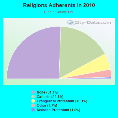
| Religion | Adherents | Congregations |
|---|---|---|
| Catholic | 9,000 | 13 |
| Evangelical Protestant | 2,749 | 32 |
| Other | 1,279 | 6 |
| Mainline Protestant | 285 | 2 |
| None | 13,900 | - |
Food Environment Statistics:
| This county: | 0.73 / 10,000 pop. |
| State: | 1.44 / 10,000 pop. |
| Cibola County: | 0.37 / 10,000 pop. |
| New Mexico: | 0.21 / 10,000 pop. |
| Here: | 5.14 / 10,000 pop. |
| New Mexico: | 4.06 / 10,000 pop. |
| This county: | 4.04 / 10,000 pop. |
| New Mexico: | 7.12 / 10,000 pop. |
| Cibola County: | 10.6% |
| New Mexico: | 6.4% |
| Cibola County: | 28.1% |
| New Mexico: | 22.1% |
Strongest AM radio stations in Zuni-Ramah Navajo:
- KHAC (880 AM; 43 kW; TSE BONITO, NM; Owner: WESTERN INDIAN MINISTRIES, INC.)
- KTNN (660 AM; 50 kW; WINDOW ROCK, AZ; Owner: THE NAVAJO NATION)
- KRKE (1100 AM; 5 kW; MILAN, NM; Owner: CIBOLA RADIO COMPANY)
- KKOB (770 AM; 50 kW; ALBUQUERQUE, NM; Owner: CITADEL BROADCASTING COMPANY)
- KGAK (1330 AM; 5 kW; GALLUP, NM; Owner: KRJG, INC.)
- KMIA (710 AM; 50 kW; BLACK CANYON CITY, AZ; Owner: ENTRAVISION HOLDINGS, LLC)
- KFLT (830 AM; 50 kW; TUCSON, AZ; Owner: FAMILY LIFE B/CING SYSTEM, INC.)
- KFNX (1100 AM; 50 kW; CAVE CREEK, AZ; Owner: NORTH AMERICAN BROADCASTING CO., INC.)
- KKIM (1000 AM; 10 kW; ALBUQUERQUE, NM; Owner: AGM-NEVADA, LLC)
- KMIN (980 AM; 1 kW; GRANTS, NM; Owner: KD RADIO, INC.)
- KXKS (1190 AM; 10 kW; ALBUQUERQUE, NM; Owner: CLEAR CHANNEL BROADCASTING LICENSES, INC.)
- KINF (1020 AM; 50 kW; ROSWELL, NM; Owner: JAMES CRYSTAL HOLDINGS OF NEW MEXICO, INC.)
- KNML (610 AM; 5 kW; ALBUQUERQUE, NM; Owner: CITADEL BROADCASTING COMPANY)
Strongest FM radio stations in Zuni-Ramah Navajo:
- KTDB (89.7 FM; RAMAH, NM; Owner: RAMAH NAVAJO SCHOOL BOARD, INC.)
- KQLV (105.5 FM; GRANTS, NM; Owner: EDUCATIONAL MEDIA FOUNDATION)
- KXTC (99.9 FM; THOREAU, NM; Owner: KXTC, L.L.C.)
- KTEG (104.7 FM; BOSQUE FARMS, NM; Owner: CLEAR CHANNEL BROADCASTING LICENSES, INC.)
- KYVA (103.7 FM; GRANTS, NM; Owner: MILLENNIUM MEDIA, INC.)
- KKOR (94.5 FM; GALLUP, NM; Owner: MILLENNIUM MEDIA, INC.)
- KXXI (93.7 FM; GALLUP, NM; Owner: MILLENNIUM MEDIA, INC.)
- KGLX (99.1 FM; GALLUP, NM; Owner: CLEAR CHANNEL BROADCASTING LICENSES, INC.)
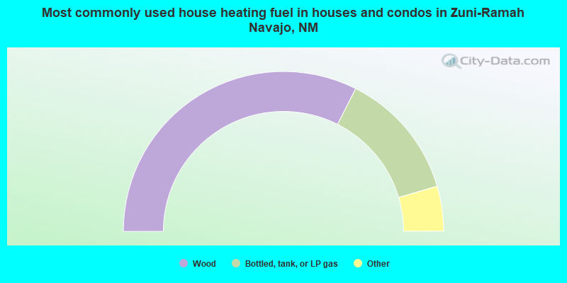
- 64.9%Wood
- 26.0%Bottled, tank, or LP gas
- 2.4%Electricity
- 2.0%No fuel used
- 1.6%Utility gas
- 1.6%Fuel oil, kerosene, etc.
- 1.4%Other fuel
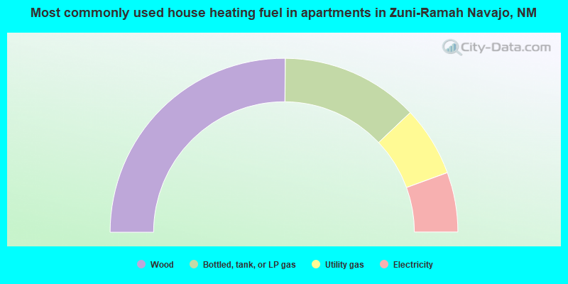
- 50.2%Wood
- 25.6%Bottled, tank, or LP gas
- 13.0%Utility gas
- 11.1%Electricity
Zuni-Ramah Navajo compared to New Mexico state average:
- Median house value significantly below state average.
- Black race population percentage significantly below state average.
- Hispanic race population percentage significantly below state average.
- Median age significantly below state average.
- Foreign-born population percentage significantly below state average.
- Length of stay since moving in significantly above state average.
- Number of rooms per house significantly below state average.
- House age significantly below state average.