Amherst, Massachusetts
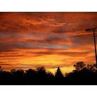
Amherst: sunset in Amherst
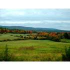
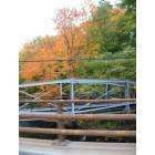
Amherst: Fall foliage in Amherst
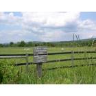
Amherst: Amherst Slobody
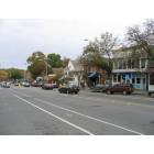
Amherst: North Pleasant Street
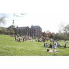
Amherst: UMass Amherst Van Meter ; April 20th
Amherst: Fall colors in Amherst
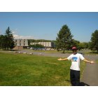
Amherst: UMASS at the back ground
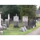
Amherst: West Cementery: Dickinsons' Graves
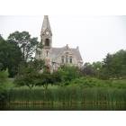
Amherst: UMass: The Old Chapel
- add
your
Submit your own pictures of this town and show them to the world
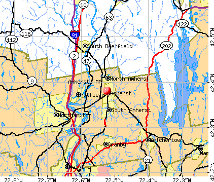
- OSM Map
- General Map
- Google Map
- MSN Map
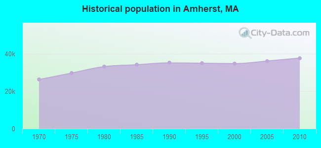
Population change since 2000: +8.4%
 |
| Males: 18,500 | |
| Females: 19,319 |
| Median resident age: | 21.6 years |
| Massachusetts median age: | 39.2 years |
Zip codes: 01002.
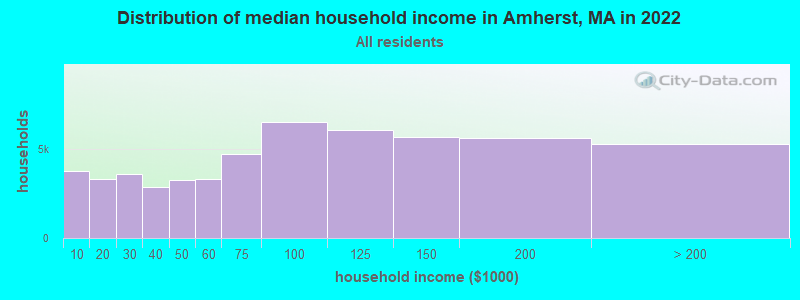
| Amherst: | $71,251 |
| MA: | $94,488 |
Estimated per capita income in 2022: $33,428 (it was $17,427 in 2000)
Amherst town income, earnings, and wages data
Estimated median house or condo value in 2022: $457,143 (it was $175,900 in 2000)
| Amherst: | $457,143 |
| MA: | $534,700 |
Mean prices in 2022: all housing units: $406,762; detached houses: $418,541; townhouses or other attached units: $363,334; in 2-unit structures: $269,911; in 3-to-4-unit structures: $561,325; in 5-or-more-unit structures: $236,751; mobile homes: $362,036
Detailed information about poverty and poor residents in Amherst, MA


- 27,71773.3%White alone
- 4,10910.9%Asian alone
- 2,7577.3%Hispanic
- 1,8154.8%Black alone
- 1,2173.2%Two or more races
- 1460.4%Other race alone
- 470.1%American Indian alone
- 110.03%Native Hawaiian and Other
Pacific Islander alone
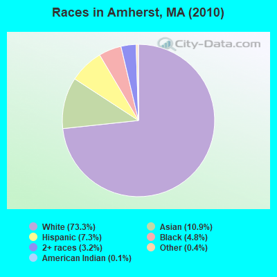
Races in Amherst detailed stats: ancestries, foreign born residents, place of birth
According to our research of Massachusetts and other state lists, there were 7 registered sex offenders living in Amherst, Massachusetts as of April 18, 2024.
The ratio of all residents to sex offenders in Amherst is 5,403 to 1.
The ratio of registered sex offenders to all residents in this city is much lower than the state average.
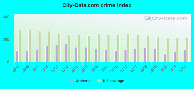
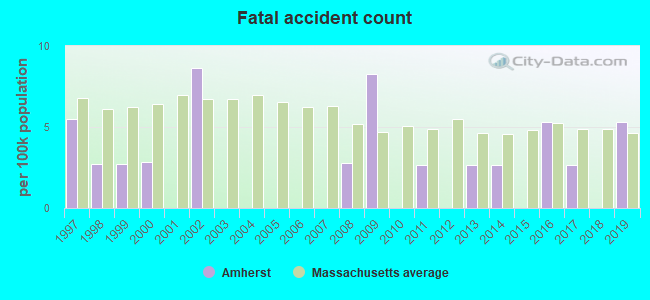
Type |
2009 |
2010 |
2011 |
2012 |
2013 |
2014 |
2015 |
2016 |
2017 |
2018 |
2019 |
2020 |
2021 |
2022 |
|---|---|---|---|---|---|---|---|---|---|---|---|---|---|---|
| Murders (per 100,000) | 0 (0.0) | 0 (0.0) | 0 (0.0) | 0 (0.0) | 0 (0.0) | 0 (0.0) | 0 (0.0) | 1 (2.5) | 0 (0.0) | 0 (0.0) | 0 (0.0) | 0 (0.0) | 0 (0.0) | 0 (0.0) |
| Rapes (per 100,000) | 17 (46.1) | 20 (52.9) | 19 (49.9) | 27 (70.8) | 23 (58.8) | 20 (51.3) | 18 (44.9) | 20 (49.9) | 20 (49.6) | 27 (67.1) | 29 (73.2) | 20 (49.9) | 27 (66.1) | 35 (89.1) |
| Robberies (per 100,000) | 5 (13.6) | 2 (5.3) | 4 (10.5) | 4 (10.5) | 3 (7.7) | 7 (18.0) | 9 (22.5) | 4 (10.0) | 3 (7.4) | 2 (5.0) | 2 (5.1) | 4 (10.0) | 1 (2.4) | 1 (2.5) |
| Assaults (per 100,000) | 50 (135.7) | 59 (156.0) | 59 (155.1) | 49 (128.6) | 44 (112.5) | 42 (107.8) | 53 (132.3) | 63 (157.3) | 80 (198.4) | 93 (231.1) | 69 (174.2) | 38 (94.9) | 40 (97.9) | 40 (101.9) |
| Burglaries (per 100,000) | 242 (656.8) | 274 (724.5) | 165 (433.6) | 92 (241.4) | 76 (194.2) | 95 (243.7) | 55 (137.3) | 66 (164.7) | 54 (134.0) | 45 (111.8) | 55 (138.9) | 18 (44.9) | 29 (71.0) | 29 (73.9) |
| Thefts (per 100,000) | 264 (716.5) | 257 (679.6) | 201 (528.3) | 242 (635.0) | 274 (700.3) | 175 (449.0) | 189 (471.9) | 164 (409.4) | 206 (511.0) | 121 (300.7) | 104 (262.6) | 72 (179.7) | 99 (242.4) | 97 (247.0) |
| Auto thefts (per 100,000) | 26 (70.6) | 29 (76.7) | 18 (47.3) | 9 (23.6) | 18 (46.0) | 18 (46.2) | 14 (35.0) | 11 (27.5) | 7 (17.4) | 11 (27.3) | 15 (37.9) | 14 (34.9) | 11 (26.9) | 4 (10.2) |
| Arson (per 100,000) | 1 (2.7) | 1 (2.6) | 0 (0.0) | 2 (5.2) | 5 (12.8) | 4 (10.3) | 0 (0.0) | 2 (5.0) | 3 (7.4) | 3 (7.5) | 2 (5.1) | 1 (2.5) | 1 (2.4) | 1 (2.5) |
| City-Data.com crime index | 148.4 | 159.1 | 129.4 | 129.7 | 117.1 | 106.7 | 100.5 | 109.5 | 112.8 | 123.4 | 118.2 | 75.0 | 90.0 | 108.3 |
The City-Data.com crime index weighs serious crimes and violent crimes more heavily. Higher means more crime, U.S. average is 246.1. It adjusts for the number of visitors and daily workers commuting into cities.
Crime rate in Amherst detailed stats: murders, rapes, robberies, assaults, burglaries, thefts, arson
Full-time law enforcement employees in 2021, including police officers: 46 (43 officers - 37 male; 6 female).
| Officers per 1,000 residents here: | 1.05 |
| Massachusetts average: | 2.53 |
 Recent articles from our blog. Our writers, many of them Ph.D. graduates or candidates, create easy-to-read articles on a wide variety of topics.


Latest news from Amherst, MA collected exclusively by city-data.com from local newspapers, TV, and radio stations
Amherst, MA City Guides:
Ancestries: Irish (19.6%), English (12.4%), German (10.1%), Italian (9.7%), Polish (6.6%), French (5.2%).
Current Local Time: EST time zone
Incorporated in 1775
Elevation: 295 feet
Land area: 27.7 square miles.
Population density: 1,364 people per square mile (low).
4,605 residents are foreign born (7.7% Asia, 2.2% Europe, 2.1% Latin America).
| This town: | 13.2% |
| Massachusetts: | 12.2% |
| Amherst town: | 1.8% ($3,079) |
| Massachusetts: | 1.3% ($2,336) |
Nearest city with pop. 50,000+: Chicopee, MA  (14.6 miles , pop. 54,653).
Nearest city with pop. 200,000+: Boston, MA (72.8 miles , pop. 589,141).
Nearest city with pop. 1,000,000+: Bronx, NY (126.9 miles , pop. 1,332,650).
Nearest cities:
), ), ), ), Latitude: 42.37 N, Longitude: 72.51 W
Area code: 413

Amherst, Massachusetts accommodation & food services, waste management - Economy and Business Data
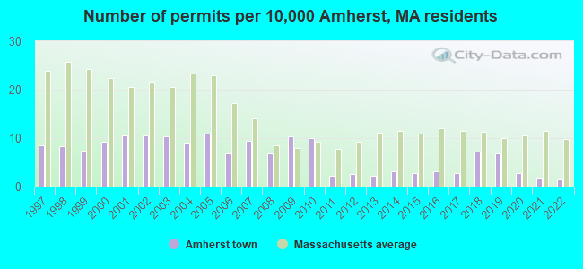
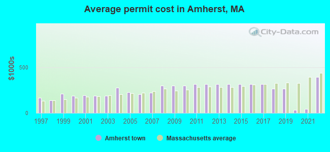
Single-family new house construction building permits:
- 2022: 5 buildings, average cost: $391,100
- 2021: 6 buildings, average cost: $45,300
- 2020: 10 buildings, average cost: $34,500
- 2019: 24 buildings, average cost: $266,200
- 2018: 25 buildings, average cost: $266,200
- 2017: 10 buildings, average cost: $314,200
- 2016: 11 buildings, average cost: $314,200
- 2015: 10 buildings, average cost: $314,200
- 2014: 11 buildings, average cost: $314,200
- 2013: 8 buildings, average cost: $314,200
- 2012: 9 buildings, average cost: $314,200
- 2011: 8 buildings, average cost: $314,200
- 2010: 35 buildings, average cost: $297,700
- 2009: 36 buildings, average cost: $297,700
- 2008: 24 buildings, average cost: $297,700
- 2007: 33 buildings, average cost: $221,400
- 2006: 24 buildings, average cost: $203,800
- 2005: 38 buildings, average cost: $229,300
- 2004: 31 buildings, average cost: $275,900
- 2003: 36 buildings, average cost: $187,300
- 2002: 37 buildings, average cost: $185,800
- 2001: 37 buildings, average cost: $193,600
- 2000: 32 buildings, average cost: $187,000
- 1999: 26 buildings, average cost: $208,700
- 1998: 29 buildings, average cost: $141,000
- 1997: 30 buildings, average cost: $166,700
| Here: | 3.1% |
| Massachusetts: | 3.5% |
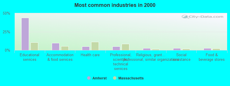
- Educational services (43.9%)
- Accommodation & food services (9.7%)
- Health care (5.2%)
- Professional, scientific, technical services (5.0%)
- Religious, grantmaking, civic, professional, similar organizations (2.8%)
- Social assistance (2.8%)
- Food & beverage stores (2.7%)
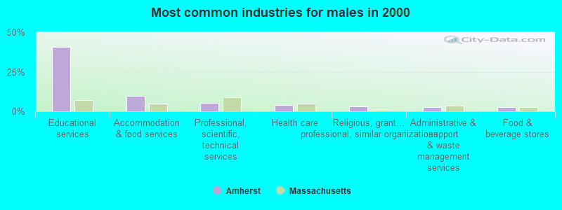
- Educational services (40.8%)
- Accommodation & food services (9.7%)
- Professional, scientific, technical services (5.2%)
- Health care (3.8%)
- Religious, grantmaking, civic, professional, similar organizations (3.1%)
- Administrative & support & waste management services (2.7%)
- Food & beverage stores (2.6%)
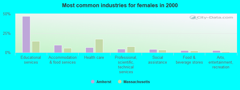
- Educational services (46.8%)
- Accommodation & food services (9.6%)
- Health care (6.4%)
- Professional, scientific, technical services (4.7%)
- Social assistance (4.2%)
- Food & beverage stores (2.9%)
- Arts, entertainment, recreation (2.8%)
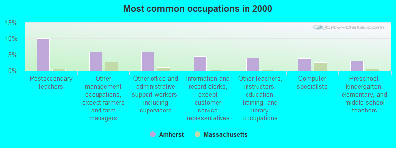
- Postsecondary teachers (10.1%)
- Other management occupations, except farmers and farm managers (5.9%)
- Other office and administrative support workers, including supervisors (5.8%)
- Information and record clerks, except customer service representatives (4.5%)
- Other teachers, instructors, education, training, and library occupations (4.0%)
- Computer specialists (3.8%)
- Preschool, kindergarten, elementary, and middle school teachers (3.2%)
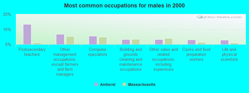
- Postsecondary teachers (13.4%)
- Other management occupations, except farmers and farm managers (6.8%)
- Computer specialists (5.6%)
- Building and grounds cleaning and maintenance occupations (3.3%)
- Other sales and related occupations, including supervisors (3.3%)
- Cooks and food preparation workers (3.2%)
- Life and physical scientists (2.8%)
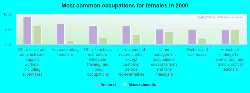
- Other office and administrative support workers, including supervisors (9.1%)
- Postsecondary teachers (7.0%)
- Other teachers, instructors, education, training, and library occupations (6.3%)
- Information and record clerks, except customer service representatives (6.1%)
- Other management occupations, except farmers and farm managers (5.0%)
- Waiters and waitresses (4.9%)
- Preschool, kindergarten, elementary, and middle school teachers (4.8%)
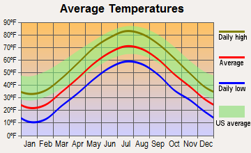
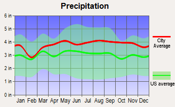
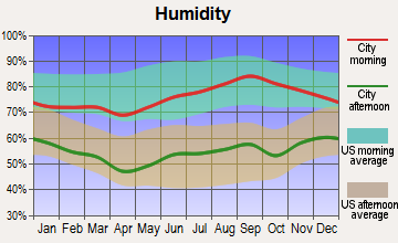
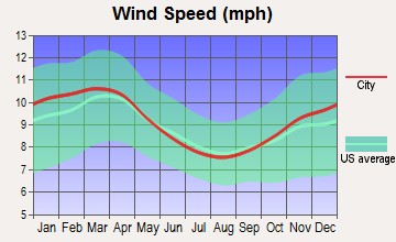
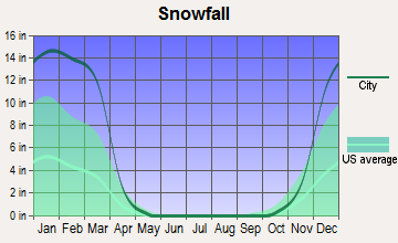
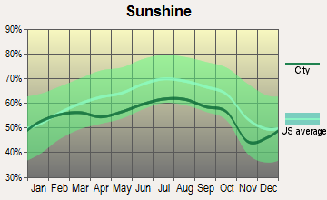
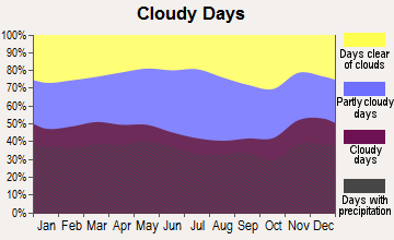
Average climate in Amherst, Massachusetts
Based on data reported by over 4,000 weather stations
(lower is better)
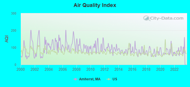
Air Quality Index (AQI) level in 2022 was 74.4. This is about average.
| City: | 74.4 |
| U.S.: | 72.6 |
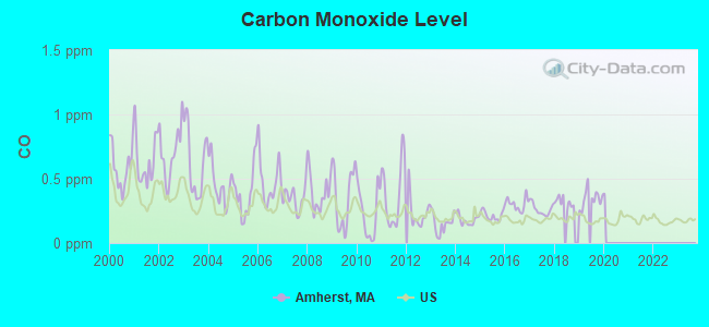
Carbon Monoxide (CO) [ppm] level in 2019 was 0.346. This is worse than average. Closest monitor was 13.6 miles away from the city center.
| City: | 0.346 |
| U.S.: | 0.251 |

Nitrogen Dioxide (NO2) [ppb] level in 2001 was 9.83. This is significantly worse than average. Closest monitor was 13.2 miles away from the city center.
| City: | 9.83 |
| U.S.: | 5.11 |
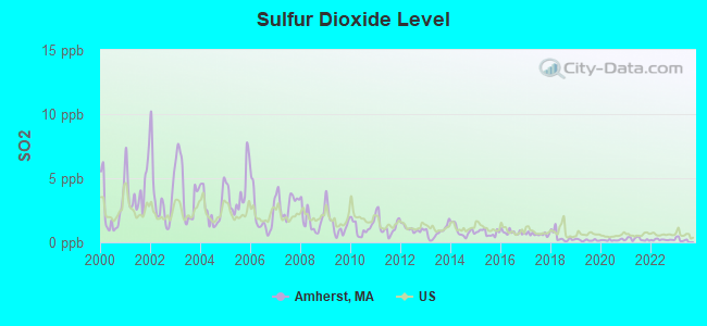
Sulfur Dioxide (SO2) [ppb] level in 2022 was 0.198. This is significantly better than average. Closest monitor was 4.6 miles away from the city center.
| City: | 0.198 |
| U.S.: | 1.515 |
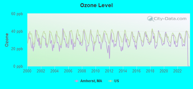
Ozone [ppb] level in 2022 was 29.9. This is about average. Closest monitor was 1.3 miles away from the city center.
| City: | 29.9 |
| U.S.: | 33.3 |
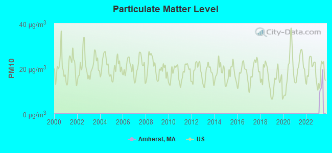
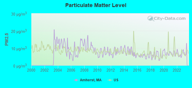
Particulate Matter (PM2.5) [µg/m3] level in 2022 was 6.77. This is about average. Closest monitor was 10.5 miles away from the city center.
| City: | 6.77 |
| U.S.: | 8.11 |
Tornado activity:
Amherst-area historical tornado activity is above Massachusetts state average. It is 8% smaller than the overall U.S. average.
On 6/9/1953, a category F4 (max. wind speeds 207-260 mph) tornado 18.7 miles away from the Amherst town center killed 90 people and injured 1228 people and caused between $50,000,000 and $500,000,000 in damages.
On 10/3/1979, a category F4 tornado 24.4 miles away from the town center killed 3 people and injured 500 people and caused between $50,000,000 and $500,000,000 in damages.
Earthquake activity:
Amherst-area historical earthquake activity is significantly above Massachusetts state average. It is 70% smaller than the overall U.S. average.On 10/7/1983 at 10:18:46, a magnitude 5.3 (5.1 MB, 5.3 LG, 5.1 ML, Class: Moderate, Intensity: VI - VII) earthquake occurred 143.0 miles away from the city center
On 4/20/2002 at 10:50:47, a magnitude 5.3 (5.3 ML, Depth: 3.0 mi) earthquake occurred 159.5 miles away from Amherst center
On 4/20/2002 at 10:50:47, a magnitude 5.2 (5.2 MB, 4.2 MS, 5.2 MW, 5.0 MW) earthquake occurred 158.2 miles away from the city center
On 1/19/1982 at 00:14:42, a magnitude 4.7 (4.5 MB, 4.7 MD, 4.5 LG, Class: Light, Intensity: IV - V) earthquake occurred 90.6 miles away from the city center
On 10/16/2012 at 23:12:25, a magnitude 4.7 (4.7 ML, Depth: 10.0 mi) earthquake occurred 126.4 miles away from Amherst center
On 10/2/1994 at 11:27:22, a magnitude 3.7 (3.5 LG, 3.7 LG, Depth: 6.2 mi, Class: Light, Intensity: II - III) earthquake occurred 12.2 miles away from the city center
Magnitude types: regional Lg-wave magnitude (LG), body-wave magnitude (MB), duration magnitude (MD), local magnitude (ML), surface-wave magnitude (MS), moment magnitude (MW)
Natural disasters:
The number of natural disasters in Hampshire County (21) is greater than the US average (15).Major Disasters (Presidential) Declared: 10
Emergencies Declared: 10
Causes of natural disasters: Floods: 5, Snowstorms: 5, Storms: 5, Hurricanes: 4, Winter Storms: 4, Blizzards: 2, Snows: 2, Snowfall: 1, Tropical Storm: 1, Wind: 1, Other: 1 (Note: some incidents may be assigned to more than one category).
Hospitals and medical centers in Amherst:
Colleges/Universities in Amherst:
- University of Massachusetts-Amherst (Full-time enrollment: 26,583; Location: 374 Whitmore Building 181 Presidents Drive; Public; Website: www.umass.edu; Offers Doctor's degree)
- Amherst College (Full-time enrollment: 1,961; Location: Boltwood Avenue; Private, not-for-profit; Website: www.amherst.edu)
- Hampshire College (Full-time enrollment: 1,430; Location: 893 West St; Private, not-for-profit; Website: www.hampshire.edu)
Other colleges/universities with over 2000 students near Amherst:
- Smith College (about 8 miles; Northampton, MA; Full-time enrollment: 3,549)
- Mount Holyoke College (about 9 miles; South Hadley, MA; FT enrollment: 2,573)
- Holyoke Community College (about 15 miles; Holyoke, MA; FT enrollment: 4,911)
- Western New England University (about 18 miles; Springfield, MA; FT enrollment: 3,477)
- American International College (about 19 miles; Springfield, MA; FT enrollment: 2,733)
- Springfield Technical Community College (about 19 miles; Springfield, MA; FT enrollment: 4,750)
- Springfield College (about 19 miles; Springfield, MA; FT enrollment: 3,144)
Public high school in Amherst:
- AMHERST REGIONAL HIGH (Students: 1,304, Location: 21 MATTOON STREET, Grades: 9-12)
Public elementary/middle schools in Amherst:
- AMHERST REGIONAL MIDDLE SCHOOL (Students: 553, Location: 170 CHESTNUT STREET, Grades: 7-8)
- FORT RIVER ELEMENTARY (Students: 468, Location: 70 SO EAST STREET, Grades: KG-6)
- WILDWOOD ELEMENTARY (Students: 434, Location: 71 STRONG STREET, Grades: KG-6)
- CROCKER FARM ELEMENTARY (Students: 365, Location: 280 WEST STREET, Grades: PK-6)
Private elementary/middle school in Amherst:
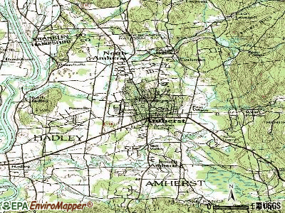
Points of interest:
Notable locations in Amherst: Atkins Farms (A), Buczala Farm (B), Small Ones Farm (C), Amherst Shoppers Park (D), Amherst Field Office and Research Park (E), Amherst Golf Course (F), Cherry Hill Cross Country Ski Center (G), Cherry Hill Golf Course (H), Hickory RIdge Country Club (I), Pratt Pool (J), Hitchcock House (K), Holdsworth Hall (L), Humphries House (M), James Hall (N), Jenkins Hall (O), Jones Library (P), Keefe Campus Center (Q), Keefe Health Center (R), Kirby Theater (S), Knowles Hall (T). Display/hide their locations on the map
Churches in Amherst include: Old Chapel (A), North Congregational Church (B), Johnson Chapel (C), Immanuel Lutheran Church (D), Hope Community Church (E), Hampshire Hispanic Ministry Church (F), Grace Episcopal Church (G), Goodwin African Methodist Episcopal Zion Church (H), First Congregational Church (I). Display/hide their locations on the map
Cemeteries: Wildwood Cemetery (1), West Cemetery (2), North Amherst Cemetery (3). Display/hide their locations on the map
Lakes, reservoirs, and swamps: Campus Pond (A), Factory Hollow Pond (B), Larence Swamp (C), Hawley Swamp (D). Display/hide their locations on the map
Streams, rivers, and creeks: Hop Brook (A), Cushman Brook (B), Plum Brook (C), Adams Brook (D), Amethyst Brook (E), Doolittle Brook (F), Hearthstone Brook (G). Display/hide their locations on the map
Parks in Amherst include: Athletic Fields North (1), Amherst Common (2), Groff Park (3), Fraternity Park (4), Amethyst Conservation Area (5), War Memorial (6), Pratt Field (7), Memorial Field (8), Hitchcock Field (9). Display/hide their locations on the map
Tourist attractions: Amherst History Museum Strong House (67 Amity Street) (1), Cross-Culture Inc (Tours & Charters; 12 White Pine Road) (2). Display/hide their approximate locations on the map
Hotels: Campus Center Hotel (1 Campus Center Way) (1), Massachusetts University Of (1 Campus Center Way) (2). Display/hide their approximate locations on the map
Birthplace of: Margaret Morse Nice - Ornithologist, Sandy Darity, Jr. - Economists, Stuart Symington - Politician, Helen Palmer Geisel - Children's writer, Julie McNiven - Film actor, Michael Hixon - Diver, Charles Henry Hitchcock - Geologist, Ellen Moran - Politician, Helen Hunt Jackson - novelist, John Henry (catcher) - Baseball player.
Drinking water stations with addresses in Amherst and their reported violations in the past:
AMHERST DPW WATER DIVISION (Population served: 37,819, Surface water):Past health violations:Past monitoring violations:
- MCL, Monthly (TCR) - In JUL-2013, Contaminant: Coliform. Follow-up actions: St AO (w/o penalty) issued (JUL-26-2013)
- MCL, Monthly (TCR) - In OCT-2010, Contaminant: Coliform. Follow-up actions: St AO (w/o penalty) issued (NOV-24-2010), St Compliance achieved (APR-06-2011)
- MCL, Monthly (TCR) - In AUG-2008, Contaminant: Coliform. Follow-up actions: St AO (w/o penalty) issued (OCT-20-2008)
- MCL, Monthly (TCR) - In MAY-2008, Contaminant: Coliform. Follow-up actions: St AO (w/o penalty) issued (JUN-18-2008)
- 3 regular monitoring violations
| This town: | 2.4 people |
| Massachusetts: | 2.5 people |
| This town: | 48.4% |
| Whole state: | 63.0% |
| This town: | 5.8% |
| Whole state: | 7.0% |
Likely homosexual households (counted as self-reported same-sex unmarried-partner households)
- Lesbian couples: 1.0% of all households
- Gay men: 0.2% of all households
| This town: | 20.2% |
| Whole state: | 9.3% |
| This town: | 9.4% |
| Whole state: | 4.4% |
People in group quarters in Amherst in 2010:
- 14,952 people in college/university student housing
- 118 people in nursing facilities/skilled-nursing facilities
- 117 people in other noninstitutional facilities
- 18 people in group homes intended for adults
- 14 people in emergency and transitional shelters (with sleeping facilities) for people experiencing homelessness
- 9 people in workers' group living quarters and job corps centers
- 5 people in in-patient hospice facilities
- 3 people in residential treatment centers for adults
People in group quarters in Amherst in 2000:
- 12,252 people in college dormitories (includes college quarters off campus)
- 130 people in nursing homes
- 35 people in other noninstitutional group quarters
- 6 people in homes or halfway houses for drug/alcohol abuse
Banks with branches in Amherst (2011 data):
- TD Bank, National Association: Amherst Branch at 11 Amity Street, branch established on 1996/12/18; Triangle Street Branch at 243 Triangle Street, branch established on 1962/01/10. Info updated 2010/10/04: Bank assets: $188,912.6 mil, Deposits: $153,149.8 mil, headquarters in Wilmington, DE, positive income, 1314 total offices, Holding Company: Toronto-Dominion Bank, The
- The Northampton Co-operative Bank: College Street Branch at 390 College Street, branch established on 2010/04/12; Amherst Branch at 253 Triangle Street, branch established on 1951/10/01. Info updated 2006/11/03: Bank assets: $155.1 mil, Deposits: $126.7 mil, headquarters in Northampton, MA, positive income, Mortgage Lending Specialization, 4 total offices
- Florence Savings Bank: College Street Branch at 385 College Street, branch established on 2002/12/12. Info updated 2006/11/30: Bank assets: $1,088.0 mil, Deposits: $825.9 mil, headquarters in Florence, MA, positive income, Mortgage Lending Specialization, 10 total offices, Holding Company: Florence Bancorp, Mhc
- People's United Bank: Amherst Branch at 25 East Pleasant Street, branch established on 1994/02/15. Info updated 2012/02/16: Bank assets: $27,319.3 mil, Deposits: $20,835.4 mil, headquarters in Bridgeport, CT, positive income, Commercial Lending Specialization, 374 total offices
- PeoplesBank: Amherst Branch at 56 Amity Street, branch established on 2002/12/18. Info updated 2007/02/12: Bank assets: $1,653.1 mil, Deposits: $1,224.2 mil, headquarters in Holyoke, MA, positive income, Commercial Lending Specialization, 18 total offices, Holding Company: Peoplesbancorp, Mhc
- Greenfield Savings Bank: University Drive Branch at 6 University Drive, branch established on 2002/02/20. Info updated 2006/10/11: Bank assets: $640.0 mil, Deposits: $458.2 mil, headquarters in Greenfield, MA, positive income, Mortgage Lending Specialization, 6 total offices, Holding Company: Gsb, Mhc
- Bank of America, National Association: Amherst Center Branch at One South Pleasant Street, branch established on 1834/01/01. Info updated 2009/11/18: Bank assets: $1,451,969.3 mil, Deposits: $1,077,176.8 mil, headquarters in Charlotte, NC, positive income, 5782 total offices, Holding Company: Bank Of America Corporation
For population 15 years and over in Amherst:
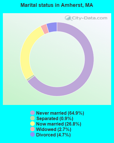
- Never married: 64.9%
- Now married: 26.8%
- Separated: 0.9%
- Widowed: 2.7%
- Divorced: 4.7%
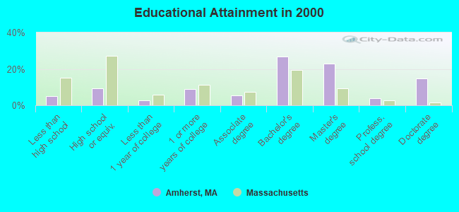
For population 25 years and over in Amherst:
- High school or higher: 95.1%
- Bachelor's degree or higher: 68.7%
- Graduate or professional degree: 41.7%
- Unemployed: 8.2%
- Mean travel time to work (commute): 18.0 minutes
| Here: | 11.7 |
| Massachusetts average: | 13.1 |
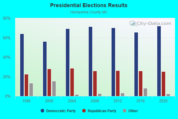
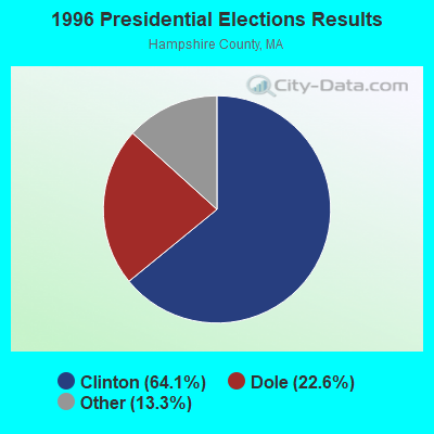
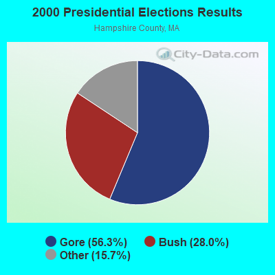
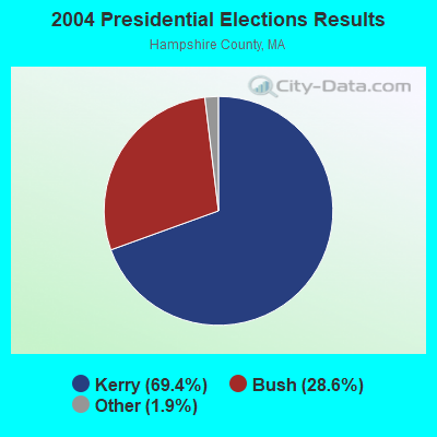
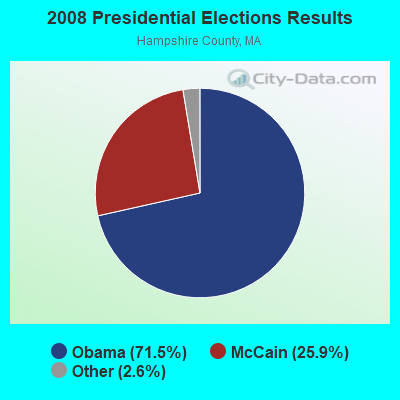
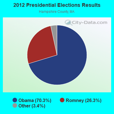
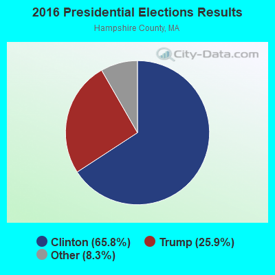
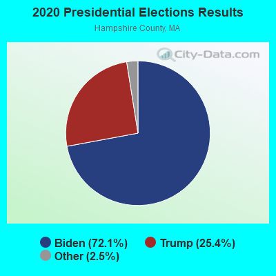
Graphs represent county-level data. Detailed 2008 Election Results
Religion statistics for Amherst, MA (based on Hampshire County data)
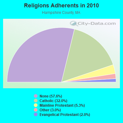
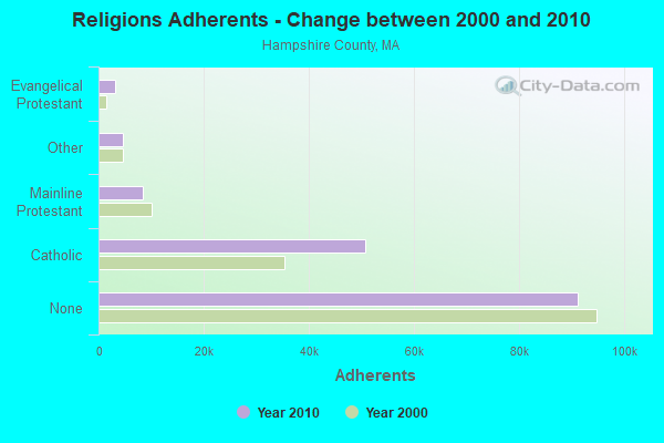
| Religion | Adherents | Congregations |
|---|---|---|
| Catholic | 50,643 | 22 |
| Mainline Protestant | 8,454 | 45 |
| Other | 4,722 | 27 |
| Evangelical Protestant | 3,128 | 22 |
| Black Protestant | 29 | 1 |
| None | 91,104 | - |
Food Environment Statistics:
| Hampshire County: | 2.07 / 10,000 pop. |
| Massachusetts: | 1.98 / 10,000 pop. |
| This county: | 0.06 / 10,000 pop. |
| State: | 0.05 / 10,000 pop. |
| Hampshire County: | 1.55 / 10,000 pop. |
| Massachusetts: | 2.22 / 10,000 pop. |
| Hampshire County: | 1.94 / 10,000 pop. |
| State: | 1.77 / 10,000 pop. |
| Here: | 10.22 / 10,000 pop. |
| State: | 8.76 / 10,000 pop. |
| This county: | 7.3% |
| Massachusetts: | 8.1% |
| Hampshire County: | 21.7% |
| Massachusetts: | 22.5% |
| This county: | 12.3% |
| State: | 16.5% |
| Businesses in Amherst, MA | ||||
| Name | Count | Name | Count | |
|---|---|---|---|---|
| CVS | 2 | Quiznos | 1 | |
| Dunkin Donuts | 2 | Starbucks | 1 | |
| FedEx | 8 | Subway | 1 | |
| Goodwill | 3 | True Value | 1 | |
| Jimmy Jazz | 1 | UPS | 16 | |
| Penske | 1 | Walgreens | 1 | |
Strongest AM radio stations in Amherst:
- WPNI (1430 AM; 5 kW; AMHERST, MA; Owner: WESTERN MASSACHUSETTS RADIO COMPANY)
- WNNZ (640 AM; 50 kW; WESTFIELD, MA; Owner: CLEAR CHANNEL BROADCASTING LICENSES, INC.)
- WCRN (830 AM; 50 kW; WORCESTER, MA; Owner: CARTER BROADCASTING CORPORATION)
- WVNE (760 AM; daytime; 25 kW; LEICESTER, MA; Owner: BLOUNT MASSCOM, INC.)
- WHYN (560 AM; 5 kW; SPRINGFIELD, MA; Owner: CLEAR CHANNEL BROADCASTING LICENSES, INC.)
- WACE (730 AM; 5 kW; CHICOPEE, MA; Owner: CARTER BROADCASTING CORP.)
- WIZZ (1520 AM; daytime; 10 kW; GREENFIELD, MA; Owner: P. & M. RADIO, LLC)
- WTIC (1080 AM; 50 kW; HARTFORD, CT; Owner: INFINITY RADIO OPERATIONS INC.)
- WALE (990 AM; 50 kW; GREENVILLE, RI; Owner: NORTH AMERICAN BROADCASTING CO., INC.)
- WRKO (680 AM; 50 kW; BOSTON, MA; Owner: ENTERCOM BOSTON LICENSE, LLC)
- WEEI (850 AM; 50 kW; BOSTON, MA; Owner: ENTERCOM BOSTON LICENSE, LLC)
- WKOX (1200 AM; 50 kW; FRAMINGHAM, MA; Owner: CAPSTAR TX LIMITED PARTNERSHIP)
- WARE (1250 AM; 5 kW; WARE, MA; Owner: SUCCESS SIGNAL BROADCASTING, INC.)
Strongest FM radio stations in Amherst:
- W246AM (97.1 FM; AMHERST, MA; Owner: GREAT NORTHERN RADIO, LLC)
- WFCR (88.5 FM; AMHERST, MA; Owner: UNIVERSITY OF MASSACHUSETTS)
- WAMH (89.3 FM; AMHERST, MA; Owner: TRUSTEES OF AMHERST COLLEGE)
- WMUA (91.1 FM; AMHERST, MA; Owner: UNIVERSITY OF MASSACHUSETTS)
- WHYN-FM (93.1 FM; SPRINGFIELD, MA; Owner: CLEAR CHANNEL BROADCASTING LICENSES, INC.)
- WRNX (100.9 FM; AMHERST, MA; Owner: WESTERN MASSACHUSETTS RADIO COMPANY)
- WLZX (99.3 FM; NORTHAMPTON, MA; Owner: SAGA COMMUNICATIONS OF NEW ENGLAND, LLC)
- WEIB (106.3 FM; NORTHAMPTON, MA; Owner: CUTTING EDGE BROADCASTING, INC.)
- WAMC-FM (90.3 FM; ALBANY, NY; Owner: WAMC)
- WAQY (102.1 FM; SPRINGFIELD, MA; Owner: SAGA COMMUNICATIONS OF NEW ENGLAND, LLC)
- WPVQ (95.3 FM; GREENFIELD, MA; Owner: GREAT NORTHERN RADIO, L.L.C.)
- WHAI (98.3 FM; GREENFIELD, MA; Owner: SAGA COMMUNICATIONS OF NEW ENGLAND, LLC)
- WGAJ (91.7 FM; DEERFIELD, MA; Owner: TRUATEES OF DEERFIELD ACADEMY)
- WAAF (107.3 FM; WORCESTER, MA; Owner: ENTERCOM BOSTON LICENSE, LLC)
- WRSI (93.9 FM; TURNERS FALLS, MA; Owner: GREAT NORTHERN RADIO, LLC)
- WEQX (102.7 FM; MANCHESTER, VT; Owner: NORTHSHIRE COMMUNICATIONS, INC.)
- WJAN (95.1 FM; SUNDERLAND, VT; Owner: 6 JOHNSON ROAD LICENSES, INC.)
- WVAY (100.7 FM; WILMINGTON, VT; Owner: GREAT NORTHERN RADIO, L.L.C.)
- WSRS (96.1 FM; WORCESTER, MA; Owner: CAPSTAR TX LIMITED PARTNERSHIP)
- WPKX (97.9 FM; ENFIELD, CT; Owner: CAPSTAR TX LIMITED PARTNERSHIP)
TV broadcast stations around Amherst:
- WYDN (Channel 48; WORCESTER, MA; Owner: EDUCATIONAL PUBLIC TV CORPORATION)
- WTIC-TV (Channel 61; HARTFORD, CT; Owner: TRIBUNE TELEVISION COMPANY)
- W11BJ (Channel 11; HARTFORD, CT; Owner: COMMUNICATIONS SITE MANAGEMENT LLC)
- WUNI (Channel 27; WORCESTER, MA; Owner: ENTRAVISION HOLDINGS, LLC)
- WWLP (Channel 22; SPRINGFIELD, MA; Owner: WWLP BROADCASTING, LLC)
- WTXX (Channel 20; WATERBURY, CT; Owner: WTXX INC.)
- W67DF (Channel 67; SPRINGFIELD, MA; Owner: TRINITY BROADCASTING NETWORK)
- WUVN (Channel 18; HARTFORD, CT; Owner: ENTRAVISION HOLDINGS, LLC)
- WGGB-TV (Channel 40; SPRINGFIELD, MA; Owner: WGGB LICENSEE, LLC)
- WGBY-TV (Channel 57; SPRINGFIELD, MA; Owner: WGBH EDUCATIONAL FOUNDATION)
- National Bridge Inventory (NBI) Statistics
- 16Number of bridges
- 95ft / 28.6mTotal length
- $15,648,000Total costs
- 116,149Total average daily traffic
- 7,762Total average daily truck traffic
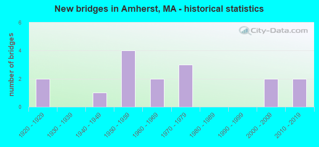
- New bridges - historical statistics
- 21920-1929
- 11940-1949
- 41950-1959
- 21960-1969
- 31970-1979
- 22000-2009
- 22010-2019
FCC Registered Cell Phone Towers:
1- 151 College Street (Lat: 42.371833 Lon: -72.512139), Type: Stack, Structure height: 45.7 m, Overall height: 47.2 m, Call Sign: KNKA252
Assigned Frequencies: 880.020 MHz, 880.020 MHz, 880.020 MHz, 835.020 MHz, 835.020 MHz, 835.020 MHz, 891.510 MHz, 891.510 MHz, 891.510 MHz, 846.510 MHz, 846.510 MHz, 846.510 MHzGrant Date: 09/07/2016, Expiration Date: 10/01/2026, Certifier: Michael P GogginRegistrant: At&t Services, Inc., 208 S Akard St, 20f, Dallas, TX 75202, Phone: (855) 699-7073, Fax: (214) 746-6410, Email:
FCC Registered Antenna Towers:
4- Marin Fettman, 740 Belchertown Road (4sh0203g) (Lat: 42.356139 Lon: -72.479583), Type: 47.9, Overall height: 47.9 m, Registrant: Omnipoint Communications Inc., Marin.Fettman@t-Mobile.Com, , Belle-vue, Phone: (425) 383-4000
- Marin Fettman, 740 Belchertown Road (4sh0203g) (Lat: 42.356139 Lon: -72.479583), Type: 47.9, Overall height: 47.9 m, Registrant: T-Mobile Northeast LLC, Fccasrrequest@t-Mobile.Com, , Belle-vue, Phone: (425) 383-4000
- Dan Menser, 740 Belchertown Road (4sh0203g) (Lat: 42.356139 Lon: -72.479583), Type: 47.9, Overall height: 47.9 m, Registrant: T-Mobile Northeast LLC, Fccasrrequest@t-Mobile.Com, , Belle-vue, Phone: (425) 383-4000
- DAN MENSER, 740 Belchertown Road (4sh0203g) (Lat: 42.356139 Lon: -72.479583), Type: 47.9, Overall height: 47.9 m, Registrant: T-Mobile Northeast LLC, Fccasrrequest@t-Mobile.Com, , Belle-vue, Phone: (425) 383-4000
FCC Registered Commercial Land Mobile Towers:
2 (See the full list of FCC Registered Commercial Land Mobile Towers in Amherst, MA)FCC Registered Broadcast Land Mobile Towers:
29 (See the full list of FCC Registered Broadcast Land Mobile Towers)FCC Registered Microwave Towers:
15 (See the full list of FCC Registered Microwave Towers in this town)FCC Registered Paging Towers:
1 (See the full list of FCC Registered Paging Towers)FCC Registered Amateur Radio Licenses:
112 (See the full list of FCC Registered Amateur Radio Licenses in Amherst)FAA Registered Aircraft:
16 (See the full list of FAA Registered Aircraft in Amherst)2002 - 2018 National Fire Incident Reporting System (NFIRS) incidents
- Fire incident types reported to NFIRS in Amherst, MA
- 79944.0%Structure Fires
- 76942.4%Outside Fires
- 1437.9%Mobile Property/Vehicle Fires
- 1035.7%Other
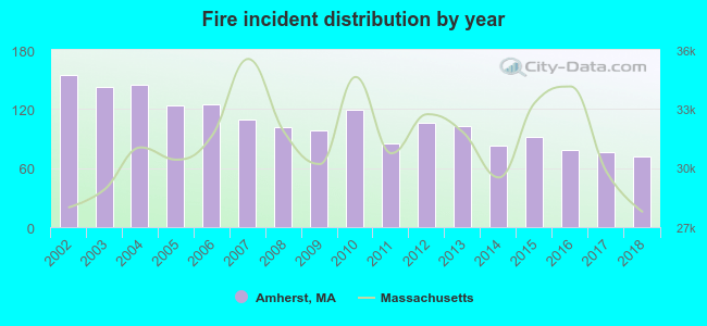 Based on the data from the years 2002 - 2018 the average number of fire incidents per year is 107. The highest number of fires - 155 took place in 2002, and the least - 72 in 2018. The data has a decreasing trend.
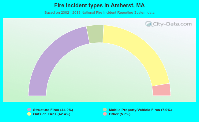 When looking into fire subcategories, the most incidents belonged to: Structure Fires (44.0%), and Outside Fires (42.4%).
| Most common first names in Amherst, MA among deceased individuals | ||
| Name | Count | Lived (average) |
|---|---|---|
| Mary | 113 | 83.7 years |
| John | 102 | 76.0 years |
| William | 79 | 79.2 years |
| Helen | 71 | 83.1 years |
| Robert | 63 | 74.7 years |
| George | 55 | 78.9 years |
| Ruth | 52 | 86.6 years |
| Charles | 50 | 79.5 years |
| Joseph | 49 | 77.0 years |
| Elizabeth | 47 | 83.6 years |
| Most common last names in Amherst, MA among deceased individuals | ||
| Last name | Count | Lived (average) |
|---|---|---|
| Smith | 32 | 83.7 years |
| Brown | 20 | 79.0 years |
| Sullivan | 20 | 77.0 years |
| White | 19 | 82.2 years |
| Johnson | 19 | 75.2 years |
| Jones | 18 | 72.0 years |
| Mitchell | 17 | 73.8 years |
| Thompson | 17 | 84.8 years |
| Allen | 17 | 82.3 years |
| Roberts | 15 | 88.1 years |
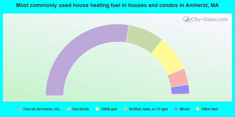
- 55.1%Fuel oil, kerosene, etc.
- 16.4%Electricity
- 16.2%Utility gas
- 7.4%Bottled, tank, or LP gas
- 4.2%Wood
- 0.8%Other fuel
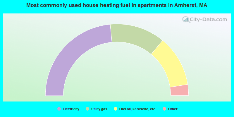
- 47.0%Electricity
- 25.0%Utility gas
- 23.0%Fuel oil, kerosene, etc.
- 3.7%Bottled, tank, or LP gas
- 0.5%Other fuel
- 0.4%Wood
- 0.2%No fuel used
- 0.2%Solar energy
Amherst compared to Massachusetts state average:
- Unemployed percentage below state average.
- Median age significantly below state average.
- Length of stay since moving in significantly above state average.
- Number of rooms per house significantly below state average.
- House age significantly below state average.
- Number of college students significantly above state average.
- Percentage of population with a bachelor's degree or higher above state average.
Amherst on our top lists:
- #2 on the list of "Top 101 cities with largest percentage of males in occupations: postsecondary teachers (population 5,000+)"
- #3 on the list of "Top 101 cities with largest percentage of females in occupations: postsecondary teachers (population 5,000+)"
- #12 on the list of "Top 101 cities with largest percentage of males in occupations: information and record clerks except customer service representatives (population 5,000+)"
- #13 on the list of "Top 101 cities with largest percentage of males in occupations: secretaries and administrative assistants (population 5,000+)"
- #14 on the list of "Top 101 cities with largest percentage of females in occupations: other teachers and instructors, education, training, and library occupations (population 5,000+)"
- #15 on the list of "Top 101 cities with largest percentage of females in industries: educational services (population 5,000+)"
- #17 on the list of "Top 101 cities with largest percentage of males in occupations: life and physical scientists (population 5,000+)"
- #21 on the list of "Top 101 cities with the most people walking to work (population 5,000+)"
- #22 on the list of "Top 101 cities with largest percentage of males in industries: educational services (population 5,000+)"
- #31 on the list of "Top 101 cities with the most people having Master's or Doctorate degrees (population 5,000+)"
- #32 on the list of "Top 101 cities with largest percentage of males in industries: religious, grantmaking, civic, professional, and similar organizations (population 5,000+)"
- #40 on the list of "Top 101 cities with the most people having Doctorate degrees (population 500+)"
- #51 on the list of "Top 101 cities with the largest percentage of likely lesbian couples (counted as self-reported female-female unmarried-partner households) (population 5,000+)"
- #58 on the list of "Top 101 cities with the largest percentage of people in college dormitories (includes college quarters off campus) (population 1,000+)"
- #60 on the list of "Top 100 cities with youngest residents (pop. 5,000+)"
- #67 on the list of "Top 101 cities with largest percentage of females in industries: data processing, libraries, and other information services (population 5,000+)"
- #92 on the list of "Top 101 cities with largest percentage of males in industries: social assistance (population 5,000+)"
- #94 on the list of "Top 101 cities with largest percentage of males in industries: data processing, libraries, and other information services (population 5,000+)"
- #94 on the list of "Top 101 cities with largest percentage of females in industries: rail transportation (population 5,000+)"
- #98 on the list of "Top 101 cities with largest percentage of females in industries: music stores (population 5,000+)"
- #2 on the list of "Top 101 counties with the lowest number of births per 1000 residents 2007-2013"
- #9 on the list of "Top 101 counties with the lowest Particulate Matter (PM10) Annual air pollution readings in 2012 (µg/m3)"
- #19 on the list of "Top 101 counties with the lowest average weight of females"
- #30 on the list of "Top 101 counties with highest percentage of residents voting for 3rd party candidates in the 2012 Presidential Election (pop. 50,000+)"
- #41 on the list of "Top 101 counties with the highest percentage of residents that exercised in the past month"

|
|
Total of 588 patent applications in 2008-2024.