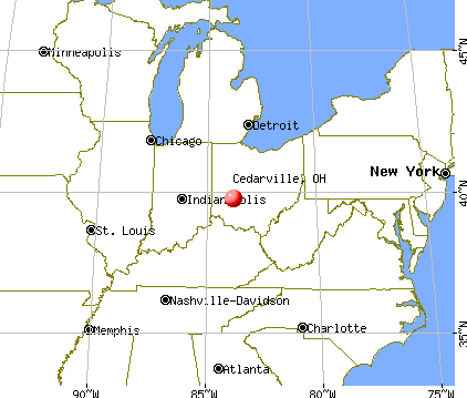
Cedarville, Ohio
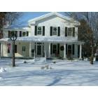
Cedarville: Snow at the Homestead

Cedarville: Fireworks at the Labor Day Festival in Cedarville, Birthplace of the Founder of Labor Day

Cedarville: The Bridge Leading Into Indian Mound Park
- add
your
Submit your own pictures of this village and show them to the world
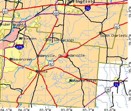
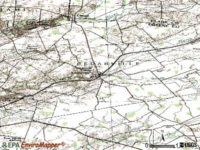
- OSM Map
- General Map
- Google Map
- MSN Map
Population change since 2000: +11.0%
 |
| Males: 2,033 | |
| Females: 2,216 |
| Median resident age: | 20.5 years |
| Ohio median age: | 39.9 years |
Zip codes: 45314.
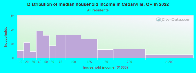
| Cedarville: | $54,258 |
| OH: | $65,720 |
Estimated per capita income in 2022: $14,807 (it was $9,499 in 2000)
Cedarville village income, earnings, and wages data
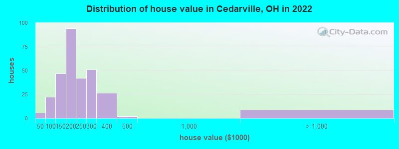
Estimated median house or condo value in 2022: $205,646 (it was $95,900 in 2000)
| Cedarville: | $205,646 |
| OH: | $204,100 |
Mean prices in 2022: all housing units: $274,563; detached houses: $278,225; townhouses or other attached units: $254,957; in 2-unit structures: $176,967; in 3-to-4-unit structures: $179,825; in 5-or-more-unit structures: $200,108; mobile homes: $85,039
Median gross rent in 2022: $838.
(20.0% for White Non-Hispanic residents, 56.1% for Black residents, 83.9% for Hispanic or Latino residents, 6.6% for two or more races residents)
Detailed information about poverty and poor residents in Cedarville, OH
Compare current foreclosures near Cedarville, OH:
| Photo | Address | Area | Beds / Baths | Price | Details |
|---|---|---|---|---|---|

|
#1
Miami Ave
Fairborn, OH 45324
|
720 sq. feet
|
1 baths 2 beds |
$8,500
|
show details |

|
#2
Delaware Ave
Springfield, OH 45506
|
1,951 sq. feet
|
1 baths 4 beds |
$87,500
|
show details |

|
#3
Arthur Rd
Springfield, OH 45502
|
2,204 sq. feet
|
2 baths 3 beds |
$354,900
|
show details |

|
#4
S Maysville Street
Bowersville, OH 45307
|
1,712 sq. feet
|
1 baths 3 beds |
show details | |

|
#5
Klose Ave
New Carlisle, OH 45344
|
999 sq. feet
|
1 baths 3 beds |
show details | |

|
#6
Blackhawk Rd
Dayton, OH 45420
|
1,050 sq. feet
|
1 baths 3 beds |
show details | |

|
#7
Van Tress Dr
Fairborn, OH 45324
|
1,126 sq. feet
|
1 baths 3 beds |
show details | |

|
#8
Us Route 68 S
Xenia, OH 45385
|
- sq. feet
|
3 baths 4 beds |
show details | |

|
#9
Woodward Ave
Springfield, OH 45506
|
- sq. feet
|
2 baths 4 beds |
show details | |

|
#10
Karr St
Springfield, OH 45503
|
1,114 sq. feet
|
1 baths 1 beds |
show details |
| Photo | Address | Area | Beds / Baths | Price | Details |
|---|---|---|---|---|---|

|
#11
Celtic Dr
Dayton, OH 45432
|
1,008 sq. feet
|
1 baths 2 beds |
show details | |

|
#12
Franlou Ave
Dayton, OH 45432
|
1,155 sq. feet
|
1 baths 4 beds |
show details | |

|
#13
W Singer St
Springfield, OH 45506
|
1,366 sq. feet
|
1 baths 1 beds |
show details | |

|
#14
Spinning Rd
Dayton, OH 45431
|
1,332 sq. feet
|
1 baths 4 beds |
show details | |

|
#15
Louisiana Dr
Xenia, OH 45385
|
3,081 sq. feet
|
3 baths 4 beds |
show details | |

|
#16
Tanager Rd
Springfield, OH 45505
|
1,053 sq. feet
|
1 baths 3 beds |
show details | |

|
#17
Ellis St St
Port William, OH 45164
|
1,120 sq. feet
|
1 baths 3 beds |
show details | |

|
#18
Frahn Ave
Fairborn, OH 45324
|
1,578 sq. feet
|
2 baths 3 beds |
show details | |

|
#19
Oaksmere St
Springfield, OH 45503
|
1,341 sq. feet
|
1 baths 3 beds |
show details | |

|
#20
Wynn Rd
Springfield, OH 45502
|
1,056 sq. feet
|
1 baths 3 beds |
show details |
| Photo | Address | Area | Beds / Baths | Price | Details |
|---|---|---|---|---|---|

|
#21
Sunburst Dr
Fairborn, OH 45324
|
1,404 sq. feet
|
1 baths 3 beds |
show details | |

|
#22
Reading Dr
Springfield, OH 45505
|
832 sq. feet
|
1 baths 2 beds |
show details | |

|
#23
Roseland Ave W
Springfield, OH 45503
|
1,104 sq. feet
|
1 baths 2 beds |
show details | |

|
#24
N Arlington Ave
Springfield, OH 45503
|
1,233 sq. feet
|
2 baths 2 beds |
show details | |

|
#25
W High St
Springfield, OH 45506
|
866 sq. feet
|
1 baths 3 beds |
show details | |

|
#26
James Dr
Fairborn, OH 45324
|
1,910 sq. feet
|
1 baths 3 beds |
show details | |

|
#27
Turner Pl
Xenia, OH 45385
|
1,841 sq. feet
|
2 baths 3 beds |
show details | |

|
#28
Kensington Dr
Bellbrook, OH 45305
|
2,222 sq. feet
|
2 baths 3 beds |
show details | |

|
#29
Wayne Dr
Fairborn, OH 45324
|
1,436 sq. feet
|
1 baths 2 beds |
show details | |

|
#30
Buxton Ave
Springfield, OH 45505
|
806 sq. feet
|
1 baths 2 beds |
show details |
| Photo | Address | Area | Beds / Baths | Price | Details |
|---|---|---|---|---|---|

|
#31
Johnson Rd
Springfield, OH 45502
|
2,328 sq. feet
|
1 baths 2 beds |
show details | |

|
#32
Axe Dr
Fairborn, OH 45324
|
1,025 sq. feet
|
1 baths 3 beds |
show details | |

|
#33
Lundgren Rd
New Carlisle, OH 45344
|
925 sq. feet
|
1 baths 3 beds |
show details | |

|
#34
Ironwood Dr
Fairborn, OH 45324
|
1,065 sq. feet
|
1 baths 3 beds |
show details | |

|
#35
N Wright Ave
Fairborn, OH 45324
|
2,710 sq. feet
|
2 baths 6 beds |
show details | |

|
#36
Softwood Ln
Dayton, OH 45424
|
1,580 sq. feet
|
2 baths 3 beds |
show details | |

|
#37
Bellefair Ave
Springfield, OH 45506
|
624 sq. feet
|
1 baths 2 beds |
show details | |

|
#38
Howard St
Springfield, OH 45503
|
976 sq. feet
|
1 baths 2 beds |
show details | |

|
#39
Hemlock Dr
Fairborn, OH 45324
|
1,008 sq. feet
|
1 baths 3 beds |
show details | |

|
#40
W North St
Springfield, OH 45504
|
1,383 sq. feet
|
1 baths 4 beds |
show details |
| Photo | Address | Area | Beds / Baths | Price | Details |
|---|---|---|---|---|---|

|
#41
Harshman Blvd
Springfield, OH 45504
|
972 sq. feet
|
1 baths 3 beds |
show details | |

|
#42
Blair Dr
Fairborn, OH 45324
|
1,604 sq. feet
|
1 baths 3 beds |
show details | |

|
#43
Diana Ln W
Fairborn, OH 45324
|
816 sq. feet
|
1 baths 3 beds |
show details | |

|
#44
Crab Tree Dr
Dayton, OH 45431
|
3,043 sq. feet
|
2 baths 3 beds |
show details | |

|
#45
Pickford Dr
Dayton, OH 45432
|
1,004 sq. feet
|
1 baths 3 beds |
show details | |

|
#46
Claydor Dr
Dayton, OH 45431
|
2,184 sq. feet
|
2 baths 4 beds |
show details | |

|
#47
Stauffer Dr
Dayton, OH 45434
|
2,711 sq. feet
|
3 baths 4 beds |
show details | |

|
#48
Sunset Dr
Fairborn, OH 45324
|
2,096 sq. feet
|
2 baths 3 beds |
show details | |

|
#49
Magnolia Ln
Fairborn, OH 45324
|
925 sq. feet
|
1 baths 3 beds |
show details | |

|
Check over 1 million property listings on Foreclosure.com!
|
browse all offers | |||


- 2,95775.1%White alone
- 64016.3%Black alone
- 1373.5%Two or more races
- 1353.4%Hispanic
- 862.2%Asian alone
- 100.3%Native Hawaiian and Other
Pacific Islander alone
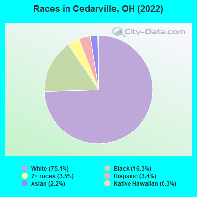
Races in Cedarville detailed stats: ancestries, foreign born residents, place of birth
According to our research of Ohio and other state lists, there were 2 registered sex offenders living in Cedarville, Ohio as of April 19, 2024.
The ratio of all residents to sex offenders in Cedarville is 2,010 to 1.
The ratio of registered sex offenders to all residents in this city is much lower than the state average.
Type |
2013 |
2018 |
2019 |
2020 |
2021 |
2022 |
|---|---|---|---|---|---|---|
| Murders (per 100,000) | 0 (0.0) | 0 (0.0) | 0 (0.0) | 0 (0.0) | 0 (0.0) | 0 (0.0) |
| Rapes (per 100,000) | 0 (0.0) | 0 (0.0) | 2 (48.2) | 2 (45.9) | 0 (0.0) | 0 (0.0) |
| Robberies (per 100,000) | 0 (0.0) | 0 (0.0) | 0 (0.0) | 0 (0.0) | 0 (0.0) | 0 (0.0) |
| Assaults (per 100,000) | 0 (0.0) | 1 (24.6) | 0 (0.0) | 0 (0.0) | 3 (68.7) | 0 (0.0) |
| Burglaries (per 100,000) | 5 (123.5) | 2 (49.1) | 0 (0.0) | 2 (45.9) | 1 (22.9) | 0 (0.0) |
| Thefts (per 100,000) | 35 (864.4) | 14 (343.7) | 16 (385.7) | 16 (366.9) | 9 (206.2) | 0 (0.0) |
| Auto thefts (per 100,000) | 1 (24.7) | 0 (0.0) | 0 (0.0) | 0 (0.0) | 1 (22.9) | 0 (0.0) |
| Arson (per 100,000) | 0 (0.0) | 0 (0.0) | 0 (0.0) | 0 (0.0) | 0 (0.0) | 0 (0.0) |
| City-Data.com crime index | 45.2 | 22.1 | 54.0 | 54.6 | 25.4 | 0.0 |
The City-Data.com crime index weighs serious crimes and violent crimes more heavily. Higher means more crime, U.S. average is 246.1. It adjusts for the number of visitors and daily workers commuting into cities.
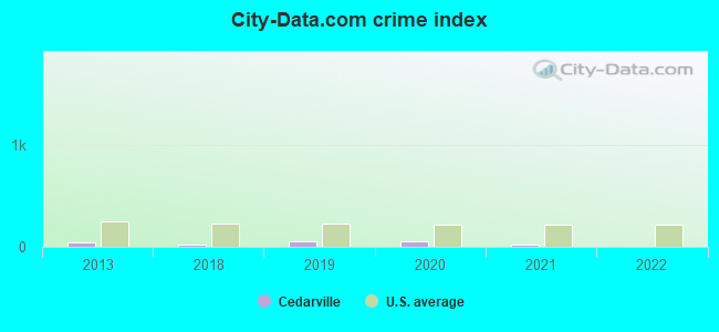
Crime rate in Cedarville detailed stats: murders, rapes, robberies, assaults, burglaries, thefts, arson
 Recent articles from our blog. Our writers, many of them Ph.D. graduates or candidates, create easy-to-read articles on a wide variety of topics.

 | Move to the Dayton area....? (50 replies) |
| Possible Relocation to Springfield Ohio and Need Information (10 replies) |
| Bellbrook Ohio or brookville? Schools, neighborhoods ,rentals? Prices? (72 replies) |
| Family with young kids moving to work at WPAFB (122 replies) |
| Relocation to WPAFB --help with schools for gifted middle schooler (48 replies) |
| Confused about property taxes in Bellbrook (26 replies) |
Latest news from Cedarville, OH collected exclusively by city-data.com from local newspapers, TV, and radio stations
Ancestries: German (17.0%), English (8.3%), Irish (5.8%), European (5.0%), American (4.3%), Arab (3.6%).
Current Local Time: EST time zone
Elevation: 1055 feet
Land area: 1.06 square miles.
Population density: 3,990 people per square mile (average).
323 residents are foreign born (3.4% Asia, 1.9% Latin America, 0.9% North America).
| This village: | 8.2% |
| Ohio: | 4.9% |
Median real estate property taxes paid for housing units with mortgages in 2022: $2,287 (1.1%)
Median real estate property taxes paid for housing units with no mortgage in 2022: $2,512 (1.2%)
Nearest city with pop. 50,000+: Springfield, OH  (12.7 miles , pop. 65,358).
Nearest city with pop. 200,000+: Columbus, OH (46.5 miles , pop. 711,470).
Nearest city with pop. 1,000,000+: Chicago, IL (249.3 miles , pop. 2,896,016).
Nearest cities:
), ), ), )Latitude: 39.74 N, Longitude: 83.81 W
Area code: 937
Property values in Cedarville, OH
Cedarville, Ohio accommodation & food services - Economy and Business Data
Single-family new house construction building permits:
- 2022: 2 buildings, average cost: $167,500
| Here: | 2.7% |
| Ohio: | 3.1% |


Population change in the 1990s: +516 (+15.6%).
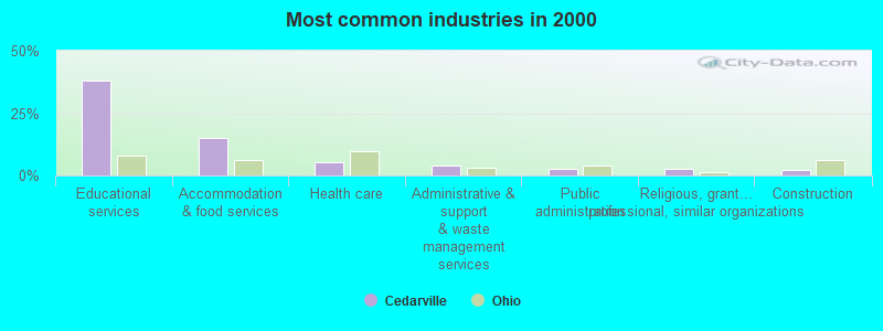
- Educational services (38.2%)
- Accommodation & food services (14.9%)
- Health care (5.2%)
- Administrative & support & waste management services (3.8%)
- Public administration (2.9%)
- Religious, grantmaking, civic, professional, similar organizations (2.6%)
- Construction (2.3%)
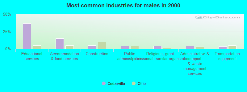
- Educational services (36.5%)
- Accommodation & food services (14.9%)
- Construction (4.7%)
- Public administration (4.3%)
- Religious, grantmaking, civic, professional, similar organizations (3.9%)
- Administrative & support & waste management services (3.9%)
- Transportation equipment (3.7%)
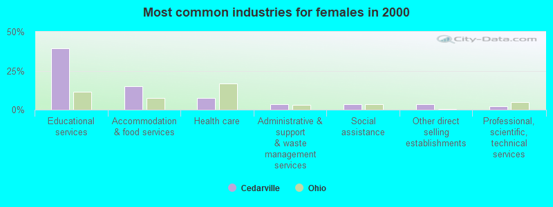
- Educational services (39.5%)
- Accommodation & food services (14.9%)
- Health care (7.4%)
- Administrative & support & waste management services (3.7%)
- Social assistance (3.5%)
- Other direct selling establishments (3.4%)
- Professional, scientific, technical services (2.1%)

- Building and grounds cleaning and maintenance occupations (8.6%)
- Other food preparation and serving workers, including supervisors (5.8%)
- Information and record clerks, except customer service representatives (5.0%)
- Other office and administrative support workers, including supervisors (4.8%)
- Waiters and waitresses (4.7%)
- Secretaries and administrative assistants (4.7%)
- Postsecondary teachers (3.6%)
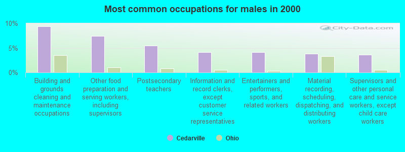
- Building and grounds cleaning and maintenance occupations (9.4%)
- Other food preparation and serving workers, including supervisors (7.4%)
- Postsecondary teachers (5.4%)
- Information and record clerks, except customer service representatives (4.2%)
- Entertainers and performers, sports, and related workers (4.2%)
- Material recording, scheduling, dispatching, and distributing workers (3.8%)
- Supervisors and other personal care and service workers, except child care workers (3.6%)

- Secretaries and administrative assistants (8.6%)
- Building and grounds cleaning and maintenance occupations (8.0%)
- Other office and administrative support workers, including supervisors (7.2%)
- Waiters and waitresses (6.8%)
- Information and record clerks, except customer service representatives (5.7%)
- Cashiers (5.1%)
- Other food preparation and serving workers, including supervisors (4.4%)
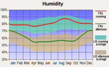
Average climate in Cedarville, Ohio
Based on data reported by over 4,000 weather stations


|
|

(lower is better)
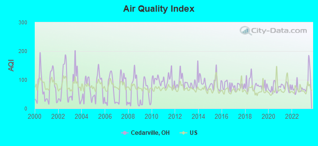
Air Quality Index (AQI) level in 2023 was 97.5. This is worse than average.
| City: | 97.5 |
| U.S.: | 72.6 |
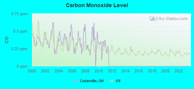
Carbon Monoxide (CO) [ppm] level in 2010 was 0.300. This is about average. Closest monitor was 12.3 miles away from the city center.
| City: | 0.300 |
| U.S.: | 0.251 |
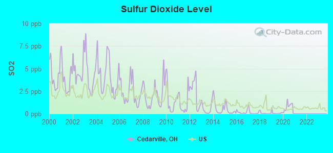
Sulfur Dioxide (SO2) [ppb] level in 2020 was 0.813. This is significantly better than average. Closest monitor was 7.1 miles away from the city center.
| City: | 0.813 |
| U.S.: | 1.515 |
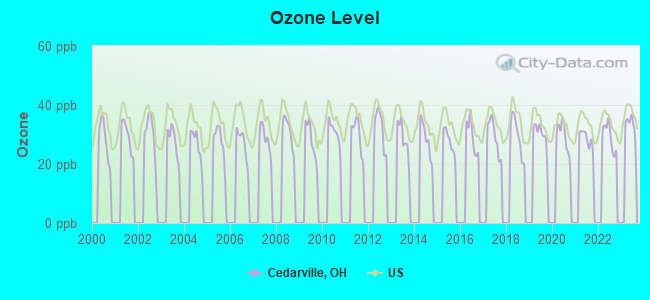
Ozone [ppb] level in 2022 was 29.3. This is about average. Closest monitor was 12.3 miles away from the city center.
| City: | 29.3 |
| U.S.: | 33.3 |
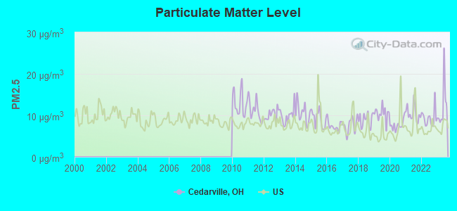
Particulate Matter (PM2.5) [µg/m3] level in 2023 was 12.2. This is significantly worse than average. Closest monitor was 6.2 miles away from the city center.
| City: | 12.2 |
| U.S.: | 8.1 |
Tornado activity:
Cedarville-area historical tornado activity is slightly above Ohio state average. It is 42% greater than the overall U.S. average.
On 4/3/1974, a category F5 (max. wind speeds 261-318 mph) tornado 15.1 miles away from the Cedarville village center killed 36 people and injured 1150 people and caused between $50,000,000 and $500,000,000 in damages.
On 9/20/2000, a category F4 (max. wind speeds 207-260 mph) tornado 4.0 miles away from the village center killed one person and injured 100 people and caused $15 million in damages.
Earthquake activity:
Cedarville-area historical earthquake activity is significantly above Ohio state average. It is 17% greater than the overall U.S. average.On 7/27/1980 at 18:52:21, a magnitude 5.2 (5.1 MB, 4.7 MS, 5.0 UK, 5.2 UK, Class: Moderate, Intensity: VI - VII) earthquake occurred 106.6 miles away from the city center
On 4/18/2008 at 09:36:59, a magnitude 5.4 (5.1 MB, 4.8 MS, 5.4 MW, 5.2 MW) earthquake occurred 236.4 miles away from the city center
On 7/12/1986 at 08:19:37, a magnitude 4.5 (4.5 MB, Class: Light, Intensity: IV - V) earthquake occurred 62.5 miles away from Cedarville center
On 9/25/1998 at 19:52:52, a magnitude 5.2 (4.8 MB, 4.3 MS, 5.2 LG, 4.5 MW, Depth: 3.1 mi) earthquake occurred 216.1 miles away from the city center
On 8/23/2011 at 17:51:04, a magnitude 5.8 (5.8 MW, Depth: 3.7 mi) earthquake occurred 340.7 miles away from the city center
On 1/31/1986 at 16:46:43, a magnitude 5.0 (5.0 MB) earthquake occurred 189.2 miles away from the city center
Magnitude types: regional Lg-wave magnitude (LG), body-wave magnitude (MB), surface-wave magnitude (MS), moment magnitude (MW)
Natural disasters:
The number of natural disasters in Greene County (12) is smaller than the US average (15).Major Disasters (Presidential) Declared: 5
Emergencies Declared: 5
Causes of natural disasters: Storms: 4, Floods: 3, Tornadoes: 3, Snows: 2, Snowstorms: 2, Winds: 2, Blizzard: 1, Heavy Rain: 1, Hurricane: 1, Landslide: 1, Mudslide: 1, Tropical Depression: 1, Other: 1 (Note: some incidents may be assigned to more than one category).
Hospitals and medical centers near Cedarville:
- FRIENDS CARE CENTER (Nursing Home, about 6 miles away; YELLOW SPRINGS, OH)
- FRIENDS EXTENDED CARE CENTER (Nursing Home, about 6 miles away; YELLOW SPRINGS, OH)
- GREENE OAKS HEALTH CENTER (Nursing Home, about 8 miles away; XENIA, OH)
- GREENE MEMORIAL HOSPITAL Acute Care Hospitals (about 8 miles away; XENIA, OH)
- HOSPITALITY HOME EAST (Nursing Home, about 8 miles away; XENIA, OH)
- LIBERTY NURSING CENTER OF XENIA (Nursing Home, about 8 miles away; XENIA, OH)
- TOWARD INDEP INC/JAMESTOWN HOM (Hospital, about 8 miles away; JAMESTOWN, OH)
Airports located in Cedarville:
- Williamson Airport (OI73) (Runways: 1)
College/University in Cedarville:
Other colleges/universities with over 2000 students near Cedarville:
- Central State University (about 5 miles; Wilberforce, OH; Full-time enrollment: 2,094)
- Clark State Community College (about 11 miles; Springfield, OH; FT enrollment: 3,689)
- Wright State University-Main Campus (about 14 miles; Dayton, OH; FT enrollment: 14,482)
- Fortis College-Centerville (about 20 miles; Centerville, OH; FT enrollment: 4,527)
- University of Dayton (about 20 miles; Dayton, OH; FT enrollment: 10,392)
- Sinclair Community College (about 21 miles; Dayton, OH; FT enrollment: 13,779)
- Edison State Community College (about 36 miles; Piqua, OH; FT enrollment: 2,049)
Public high school in Cedarville:
- CEDARVILLE HIGH SCHOOL (Students: 382, Location: 194 WALNUT ST, Grades: 6-12)
Public elementary/middle school in Cedarville:
- CEDARVILLE ELEMENTARY SCHOOL (Students: 220, Location: 248 N. MAIN ST., Grades: KG-5)
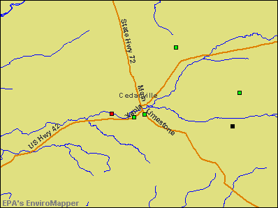
Points of interest:
Notable locations in Cedarville: Cedarville University Emergency Medical Services (A), Cedarville Township Volunteer Fire and Emergency Medical Services Department (B), Williams Hall (C), West Hall (D), Tyler Digital Communications Center (E), Stevens Student Center (F), Milner Business Administration Building (G), Maddox Hall (H), Founders Hall (I), Collins Hall (J), Centennial Library (K), Apple Technology Resource Center (L). Display/hide their locations on the map
Churches in Cedarville include: Cedarville Church of the Nazarene (A), Cedarville United Presbyterian Church (B), Cedarville United Methodist Church (C), First Church of God (D), Grace Baptist Church (E). Display/hide their locations on the map
Cemetery: North Cemetery (1). Display/hide its location on the map
Lakes and reservoirs: Flacks Pond (A), Cedarville Reservoir (B). Display/hide their locations on the map
Creeks: North Fork Massies Creek (A), South Fork Massies Creek (B). Display/hide their locations on the map
Hotel: Hearthstone Inn & Suites (10 South Main Street).
Birthplace of: Bumpus Jones - Baseball player, Whitelaw Reid - Journalist, Eleanor Parker - (1922- ) actress.
Drinking water stations with addresses in Cedarville that have no violations reported:
- CEDARVILLE UNIVERSITY (Population served: 3,800, Primary Water Source Type: Groundwater)
| This village: | 2.5 people |
| Ohio: | 2.4 people |
| This village: | 59.9% |
| Whole state: | 65.0% |
| This village: | 3.5% |
| Whole state: | 6.8% |
Likely homosexual households (counted as self-reported same-sex unmarried-partner households)
- Lesbian couples: 0.1% of all households
- Gay men: 0.1% of all households
2,091 people in college dormitories (includes college quarters off campus) in 2000
Banks with branches in Cedarville (2011 data):
- The Huntington National Bank: Cedarville at 129 North Main St, branch established on 1895/01/01. Info updated 2012/04/02: Bank assets: $54,183.4 mil, Deposits: $44,300.3 mil, headquarters in Columbus, OH, positive income, Commercial Lending Specialization, 878 total offices, Holding Company: Huntington Bancshares Incorporated
- U.S. Bank National Association: Cedarville Branch at 64 North Main Street, branch established on 1950/11/02. Info updated 2012/01/30: Bank assets: $330,470.8 mil, Deposits: $236,091.5 mil, headquarters in Cincinnati, OH, positive income, 3121 total offices, Holding Company: U.S. Bancorp
For population 15 years and over in Cedarville:
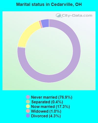
- Never married: 76.9%
- Now married: 17.3%
- Separated: 0.4%
- Widowed: 1.0%
- Divorced: 4.3%
For population 25 years and over in Cedarville:
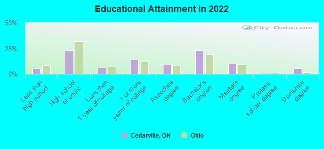
- High school or higher: 93.9%
- Bachelor's degree or higher: 40.2%
- Graduate or professional degree: 18.0%
- Unemployed: 8.2%
- Mean travel time to work (commute): 12.4 minutes
| Here: | 10.5 |
| Ohio average: | 11.0 |

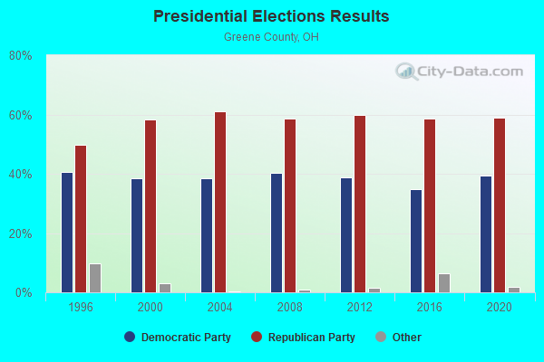
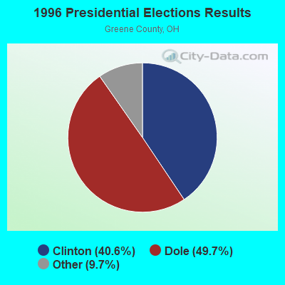
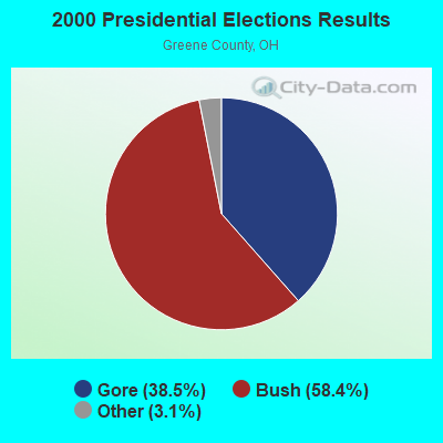

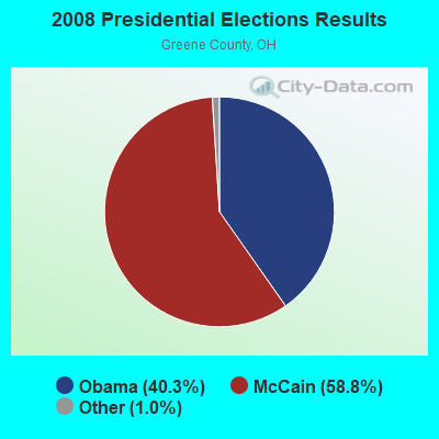
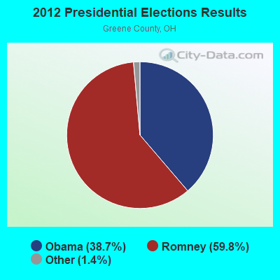


Graphs represent county-level data. Detailed 2008 Election Results
Religion statistics for Cedarville, OH (based on Greene County data)
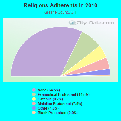
| Religion | Adherents | Congregations |
|---|---|---|
| Evangelical Protestant | 23,435 | 105 |
| Catholic | 14,064 | 5 |
| Mainline Protestant | 12,115 | 49 |
| Other | 6,403 | 15 |
| Black Protestant | 1,378 | 7 |
| None | 104,178 | - |
Food Environment Statistics:
| Greene County: | 1.39 / 10,000 pop. |
| Ohio: | 1.89 / 10,000 pop. |
| Here: | 0.13 / 10,000 pop. |
| State: | 0.13 / 10,000 pop. |
| Greene County: | 0.69 / 10,000 pop. |
| Ohio: | 1.25 / 10,000 pop. |
| Here: | 2.02 / 10,000 pop. |
| Ohio: | 2.93 / 10,000 pop. |
| Greene County: | 5.61 / 10,000 pop. |
| State: | 6.25 / 10,000 pop. |
| Here: | 9.7% |
| Ohio: | 10.3% |
| This county: | 28.6% |
| Ohio: | 29.1% |
| This county: | 11.3% |
| State: | 11.9% |
Health and Nutrition:
| This city: | 47.6% |
| State: | 50.4% |
| Cedarville: | 44.7% |
| Ohio: | 47.8% |
| Here: | 27.4 |
| Ohio: | 28.7 |
| Cedarville: | 23.2% |
| Ohio: | 20.6% |
| Cedarville: | 19.1% |
| Ohio: | 10.4% |
| This city: | 6.8 |
| Ohio: | 6.8 |
| Cedarville: | 23.8% |
| Ohio: | 34.3% |
| Here: | 58.8% |
| State: | 57.0% |
| This city: | 80.4% |
| State: | 79.1% |
More about Health and Nutrition of Cedarville, OH Residents
| Local government employment and payroll (March 2022) | |||||
| Function | Full-time employees | Monthly full-time payroll | Average yearly full-time wage | Part-time employees | Monthly part-time payroll |
|---|---|---|---|---|---|
| Police Protection - Officers | 7 | $19,251 | $33,002 | 0 | $0 |
| Streets and Highways | 2 | $6,636 | $39,816 | 0 | $0 |
| Other Government Administration | 0 | $0 | 8 | $4,886 | |
| Financial Administration | 0 | $0 | 2 | $3,926 | |
| Totals for Government | 9 | $25,887 | $34,516 | 10 | $8,812 |
Cedarville government finances - Expenditure in 2017 (per resident):
- Current Operations - Police Protection: $333,000 ($78.37)
Regular Highways: $229,000 ($53.90)
Central Staff Services: $135,000 ($31.77)
Solid Waste Management: $131,000 ($30.83)
Financial Administration: $59,000 ($13.89)
Judicial and Legal Services: $21,000 ($4.94)
Parks and Recreation: $19,000 ($4.47)
Protective Inspection and Regulation - Other: $6,000 ($1.41)
Health - Other: $2,000 ($0.47)
- Total Salaries and Wages: $399,000 ($93.90)
Cedarville government finances - Revenue in 2017 (per resident):
- Charges - Solid Waste Management: $131,000 ($30.83)
Other: $30,000 ($7.06)
Parks and Recreation: $3,000 ($0.71)
- Miscellaneous - Donations From Private Sources: $14,000 ($3.29)
- State Intergovernmental - General Local Government Support: $62,000 ($14.59)
Highways: $60,000 ($14.12)
- Tax - Individual Income: $701,000 ($164.98)
Property: $61,000 ($14.36)
Cedarville government finances - Cash and Securities in 2017 (per resident):
- Other Funds - Cash and Securities: $442,000 ($104.02)
9.10% of this county's 2021 resident taxpayers lived in other counties in 2020 ($59,043 average adjusted gross income)
| Here: | 9.10% |
| Ohio average: | 5.68% |
0.10% of residents moved from foreign countries ($943 average AGI)
Greene County: 0.10% Ohio average: 0.01%
Top counties from which taxpayers relocated into this county between 2020 and 2021:
| from Montgomery County, OH | |
| from Clark County, OH | |
| from Franklin County, OH |
9.30% of this county's 2020 resident taxpayers moved to other counties in 2021 ($61,898 average adjusted gross income)
| Here: | 9.30% |
| Ohio average: | 5.79% |
0.09% of residents moved to foreign countries ($726 average AGI)
Greene County: 0.09% Ohio average: 0.01%
Top counties to which taxpayers relocated from this county between 2020 and 2021:
| to Montgomery County, OH | |
| to Clark County, OH | |
| to Warren County, OH |
Businesses in Cedarville, OH
- Subway: 1
Strongest AM radio stations in Cedarville:
- WLW (700 AM; 50 kW; CINCINNATI, OH; Owner: JACOR BROADCASTING CORPORATION)
- WTVN (610 AM; 50 kW; COLUMBUS, OH; Owner: CITICASTERS LICENSES, L.P.)
- WGNZ (1110 AM; daytime; 2 kW; FAIRBORN, OH; Owner: L&D BROADCASTORS INC.)
- WRFD (880 AM; daytime; 23 kW; COLUMBUS-WORTHINGTON, OH; Owner: SALEM MEDIA OF OHIO, INC.)
- WONE (980 AM; 5 kW; DAYTON, OH; Owner: CITICASTERS LICENSES, L.P.)
- WHIO (1290 AM; 5 kW; DAYTON, OH; Owner: CXR HOLDINGS, INC.)
- WING (1410 AM; 5 kW; DAYTON, OH)
- WBZI (1500 AM; daytime; 0 kW; XENIA, OH; Owner: TOWN AND COUNTRY BROADCASTING, INC.)
- WSAI (1530 AM; 50 kW; CINCINNATI, OH; Owner: JACOR BROADCASTING CORPORATION)
- WIZE (1340 AM; 1 kW; SPRINGFIELD, OH; Owner: CITICASTERS LICENSES, L.P.)
- WHAS (840 AM; 50 kW; LOUISVILLE, KY; Owner: CLEAR CHANNEL BROADCASTING LICENSES, INC.)
- WOSU (820 AM; 5 kW; COLUMBUS, OH; Owner: THE OHIO STATE UNIVERSITY)
- WOWO (1190 AM; 50 kW; FORT WAYNE, IN; Owner: PATHFINDER COMMUNICATIONS CORPORATION)
Strongest FM radio stations in Cedarville:
- WYSO (91.3 FM; YELLOW SPRINGS, OH; Owner: ANTIOCH UNIVERSITY)
- WCDR-FM (90.3 FM; CEDARVILLE, OH; Owner: THE CEDARVILLE UNIVERSITY)
- WCSU-FM (88.9 FM; WILBERFORCE, OH; Owner: CENTRAL STATE UNIVERSITY)
- WRVT (88.7 FM; RUTLAND, VT; Owner: VERMONT PUBLIC RADIO)
- WZLR (95.3 FM; XENIA, OH; Owner: CXR HOLDINGS, INC.)
- WHKO (99.1 FM; DAYTON, OH; Owner: CXR HOLDINGS, INC.)
- WDHT (102.9 FM; SPRINGFIELD, OH; Owner: BLUE CHIP BROADCASTING LICENSES, LTD)
- WEEC (100.7 FM; SPRINGFIELD, OH; Owner: WORLD EVENGELISTIC ENTERPRISE CORP.)
- WLQT (99.9 FM; KETTERING, OH; Owner: CITICASTERS LICENSES, L.P.)
- WMMX (107.7 FM; DAYTON, OH; Owner: CITICASTERS LICENSES, L.P.)
- WTUE (104.7 FM; DAYTON, OH; Owner: CITICASTERS LICENSES, L.P.)
- WXEG (103.9 FM; BEAVERCREEK, OH; Owner: CITICASTERS LICENSES, L.P.)
- WRNB (92.1 FM; WEST CARROLLTON, OH; Owner: RADIO ONE OF DAYTON LICENSES, LLC)
- WKSW (101.7 FM; URBANA, OH; Owner: BLUE CHIP BROADCASTING LICENSES, LTD)
- WWSU (106.9 FM; FAIRBORN, OH; Owner: WRIGHT STATE UNIVERSITY)
- WYGY (96.5 FM; LEBANON, OH; Owner: WVAE LICO, INC.)
- WFCJ (93.7 FM; MIAMISBURG, OH; Owner: MIAMI VALLEY CHRISTIAN BROADCASTING ASSOCIATION)
- WQRP (89.5 FM; DAYTON, OH; Owner: WQRP FAMILY RADIO, INC.)
- WVNU (97.5 FM; GREENFIELD, OH; Owner: SOUTHERN OHIO BROADCASTING, INC.)
- WPFB-FM (105.9 FM; MIDDLETOWN, OH; Owner: RADIO STATIONS WPAY/WPFB, INC.)
TV broadcast stations around Cedarville:
- WBDT (Channel 26; SPRINGFIELD, OH; Owner: ACME TV LICENSES OF OHIO, LLC)
- WHIO-TV (Channel 7; DAYTON, OH; Owner: WHIO-TV HOLDINGS, INC.)
- WDTN (Channel 2; DAYTON, OH; Owner: WDTN BROADCASTING, LLC)
- WPTD (Channel 16; DAYTON, OH; Owner: GREATER DAYTON PUBLIC TV, INC.)
- WKEF (Channel 22; DAYTON, OH; Owner: WKEF LICENSEE L.P.)
- WRGT-TV (Channel 45; DAYTON, OH; Owner: WRGT LICENSEE, LLC)
- W61DE (Channel 61; CINCINNATI, OH; Owner: TRINITY BROADCASTING NETWORK)
- W47BC (Channel 47; SPRINGFIELD, OH; Owner: TRINITY BROADCASTING NETWORK)
- WWHO (Channel 53; CHILLICOTHE, OH; Owner: UPN STATIONS GROUP INC.)
- WWRD-LP (Channel 55; CENTERVILLE, OH; Owner: LIFE BROADCASTING NETWORK)
- WSYX (Channel 6; COLUMBUS, OH; Owner: WSYX LICENSEE, INC.)
- WBNS-TV (Channel 10; COLUMBUS, OH; Owner: WBNS-TV, INC.)
- WTTE (Channel 28; COLUMBUS, OH; Owner: COLUMBUS (WTTE-TV) LICENSEE, INC.)
- WRCX-LP (Channel 51; DAYTON, OH; Owner: ROSS COMMUNICATIONS, LTD.)
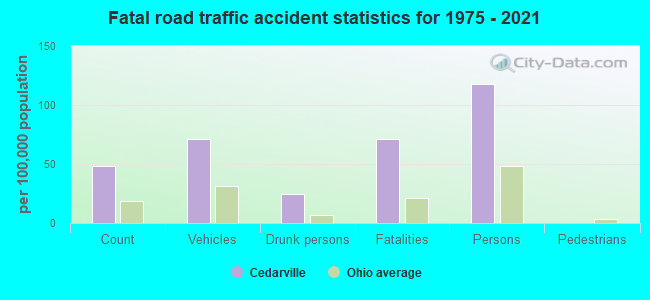
Cedarville fatal accident list:
May 8, 2003 00:30 AM, Sr-72, Vehicles: 1, Persons: 1, Fatalities: 1, Drunk persons involved: 1
- National Bridge Inventory (NBI) Statistics
- 16Number of bridges
- 89ft / 26.6mTotal length
- 19,054Total average daily traffic
- 1,086Total average daily truck traffic
- 28,479Total future (year 2024) average daily traffic

- New bridges - historical statistics
- 1Before 1900
- 11910-1919
- 51970-1979
- 31980-1989
- 31990-1999
- 12000-2009
- 22010-2019
FCC Registered Cell Phone Towers:
2 (See the full list of FCC Registered Cell Phone Towers in Cedarville)FCC Registered Antenna Towers:
34 (See the full list of FCC Registered Antenna Towers)FCC Registered Commercial Land Mobile Towers:
2- Call Sign: KA74970, Licensee ID: L00279107,
Assigned Frequencies: 450.800 MHz, Grant Date: 12/31/1981, Expiration Date: 10/01/2012, Cancellation Date: 04/04/2012, Registrant: Educational Media Foundation, 5700 West Oaks Boulevard, Rocklin, CA 95765
- Clifton Rd 4 1/2 Mi W Clifton (Lat: 39.762833 Lon: -83.884639), Structure height: 126 m, Call Sign: KPF344, Licensee ID: L00279107,
Assigned Frequencies: 455.010 MHz, Grant Date: 07/19/1984, Expiration Date: 10/01/2012, Cancellation Date: 04/04/2012, Registrant: Educational Media Foundation, 5700 West Oaks Boulevard, Rocklin, CA 95765
FCC Registered Broadcast Land Mobile Towers:
4- 3744 Turnbull Rd (Lat: 39.735611 Lon: -83.789083), Call Sign: KFK227,
Assigned Frequencies: 35.8600 MHz, Grant Date: 09/12/1996, Expiration Date: 09/11/2001, Cancellation Date: 02/10/2002, Registrant: American Aggregates Corporation, Dayton, OH 45413-7515, Phone: (513) 454-1128
- Lat: 39.747222 Lon: -83.808333, Call Sign: WPWI482,
Assigned Frequencies: 463.387 MHz, 464.612 MHz, 464.812 MHz, 468.387 MHz, 469.612 MHz, 469.812 MHz, Grant Date: 11/21/2002, Expiration Date: 11/21/2012, Cancellation Date: 01/24/2012, Certifier: Scott W Deetz, Registrant: Hardy Carey, 1080 West Causeway Approach, Mandeville, LA 70471, Phone: (985) 629-0777, Fax: (985) 629-0778
- Lat: 39.747389 Lon: -83.806167, Call Sign: WQQY516,
Assigned Frequencies: 72.1000 MHz, 72.1800 MHz, Grant Date: 03/26/2013, Expiration Date: 03/26/2023, Cancellation Date: 05/27/2023, Certifier: David Baits, Registrant: Primex Wireless, Inc., 965 Wells Street, Lake Geneva, WI 53147, Phone: (800) 537-0464
- Lat: 39.747806 Lon: -83.808361, Call Sign: WQYF232,
Assigned Frequencies: 451.300 MHz, 451.325 MHz, 451.350 MHz, Grant Date: 09/07/2016, Expiration Date: 09/07/2026, Certifier: Tommy Morgan, Registrant: P & R Communications Service, Inc., 700 E. First St., Dayton, OH 45402-1383, Phone: (937) 512-8100, Fax: (937) 512-8101, Email:
FCC Registered Microwave Towers:
4- N Main & College Sts (Lat: 39.747833 Lon: -83.809083), Overall height: 44.5 m, Call Sign: WOL56, Licensee ID: L00279107,
Assigned Frequencies: 947.350 MHz, 947.650 MHz, Grant Date: 08/17/1972, Expiration Date: 10/01/2012, Cancellation Date: 04/04/2012, Registrant: Educational Media Foundation, 5700 West Oaks Boulevard, Rocklin, CA 95765
- Cedarville, 2175 Us Rt 42 E (Lat: 39.727611 Lon: -83.848361), Type: Mast, Structure height: 86 m, Overall height: 88.1 m, Call Sign: WQIK921,
Assigned Frequencies: 11365.0 MHz, 6256.54 MHz, Grant Date: 03/06/2008, Expiration Date: 03/06/2018, Cancellation Date: 09/06/2009, Certifier: William Chastain, Registrant: Radio Dynamics Corporation, Silver Spring, MD 20914, Phone: (301) 493-5171, Fax: (301) 576-4553, Email:
- CEDARVILLE, 2891 Us 42 East (Lat: 39.736389 Lon: -83.817778), Type: Tower, Structure height: 76.2 m, Overall height: 78 m, Call Sign: WQOU815,
Assigned Frequencies: 5945.20 MHz, Grant Date: 02/06/2012, Expiration Date: 02/06/2022, Cancellation Date: 05/09/2014, Certifier: Pamelia Y Hoof, Registrant: Verizon Wireless, 1120 Sanctuary Pkwy, #150 Gasa5reg, Alpharetta, GA 30009-7630, Phone: (770) 797-1070, Fax: (770) 797-1036, Email:
- 251 N. Main St. (Lat: 39.747833 Lon: -83.809083), Overall height: 44.5 m, Call Sign: WLP554, Licensee ID: L00045774,
Assigned Frequencies: 947.500 MHz, Grant Date: 03/31/1992, Expiration Date: 10/01/2012, Cancellation Date: 02/15/2005, Registrant: The Cedarville University, P.O. Box 601, Cedarville, OH 45314
FCC Registered Paging Towers:
2- Wcdr-Fm Off Clifton Road (Lat: 39.762833 Lon: -83.884639), Call Sign: KNKK581,
Assigned Frequencies: 35.3400 MHz, Expiration Date: 04/01/1999, Cancellation Date: 06/05/1999, Registrant: U.S. Central, Inc., Lehigh Tower, East Rock Road, Allentown, PA 18103
- 2165 Us Route 42 East (Lat: 39.727556 Lon: -83.848806), Overall height: 88.4 m, Call Sign: KNKM811, Licensee ID: L01528404,
Assigned Frequencies: 931.337 MHz, Grant Date: 08/14/2018, Expiration Date: 07/01/2028, Certifier: J. Roy Pottle, Registrant: Ams Spectrum Holdings, LLC
FCC Registered Amateur Radio Licenses:
35 (See the full list of FCC Registered Amateur Radio Licenses in Cedarville)FAA Registered Aircraft:
3- Aircraft: ROBINSON HELICOPTER COMPANY R44 II (Category: Land, Seats: 4, Weight: Up to 12,499 Pounds), Engine: LYCOMING IO-540 SER (300 HP) (Reciprocating)
N-Number: 144EH, N144EH, N-144EH, Serial Number: 10742, Year manufactured: 2005, Airworthiness Date: 05/10/2005, Certificate Issue Date: 11/24/2014
Registrant (Corporation): Eagle Helicopters Inc, 2693 Selma Jamestown Rd, Cedarville, OH 45314 - Aircraft: STANLEY ROBERT M HATZ CB1 (Category: Land, Seats: 2, Weight: Up to 12,499 Pounds), Engine: CONT MOTOR 0-200 SERIES (100 HP) (Reciprocating)
N-Number: 3884Y, N3884Y, N-3884Y, Serial Number: 188, Airworthiness Date: 05/17/1985, Certificate Issue Date: 01/06/2020
Registrant (Individual): James R Johnson, Po Box 605, Cedarville, OH 45314 - Aircraft: PIPER PA-18-150 (Category: Land, Seats: 2, Weight: Up to 12,499 Pounds, Speed: 97 mph), Engine: LYCOMING 0-320 SERIES (180 HP) (Reciprocating)
N-Number: 3YR, N3YR, N-3YR, Serial Number: 18-7509113, Year manufactured: 1975, Airworthiness Date: 09/03/1986, Certificate Issue Date: 07/19/2012
Registrant (Individual): Charles Douglas Stone, 4560 Federal Rd, Cedarville, OH 45314
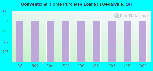
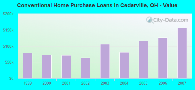
| Home Mortgage Disclosure Act Aggregated Statistics For Year 2009 (Based on 1 partial tract) | ||
| C) Refinancings | ||
|---|---|---|
| Number | Average Value | |
| LOANS ORIGINATED | 1 | $197,880 |
| APPLICATIONS APPROVED, NOT ACCEPTED | 0 | $0 |
| APPLICATIONS DENIED | 0 | $0 |
| APPLICATIONS WITHDRAWN | 0 | $0 |
| FILES CLOSED FOR INCOMPLETENESS | 0 | $0 |
Detailed HMDA statistics for the following Tracts: 2601.00
2002 - 2018 National Fire Incident Reporting System (NFIRS) incidents
- Fire incident types reported to NFIRS in Cedarville, OH
- 15251.9%Structure Fires
- 9532.4%Outside Fires
- 4114.0%Mobile Property/Vehicle Fires
- 51.7%Other
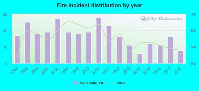 Based on the data from the years 2002 - 2018 the average number of fires per year is 17. The highest number of fires - 28 took place in 2010, and the least - 6 in 2014. The data has a decreasing trend.
 When looking into fire subcategories, the most reports belonged to: Structure Fires (51.9%), and Outside Fires (32.4%).
| Most common first names in Cedarville, OH among deceased individuals | ||
| Name | Count | Lived (average) |
|---|---|---|
| Mary | 25 | 71.3 years |
| William | 21 | 71.8 years |
| Robert | 20 | 74.0 years |
| John | 19 | 76.7 years |
| Charles | 17 | 76.3 years |
| Harold | 16 | 74.8 years |
| James | 14 | 74.7 years |
| Ruth | 13 | 81.2 years |
| Helen | 13 | 80.4 years |
| Anna | 12 | 85.8 years |
| Most common last names in Cedarville, OH among deceased individuals | ||
| Last name | Count | Lived (average) |
|---|---|---|
| Smith | 12 | 73.8 years |
| Evans | 12 | 76.2 years |
| Marshall | 10 | 67.5 years |
| Miller | 8 | 75.2 years |
| Jones | 8 | 78.8 years |
| Baldwin | 8 | 73.3 years |
| Townsley | 8 | 77.3 years |
| Shaw | 7 | 73.2 years |
| Dobbins | 7 | 83.7 years |
| Ferguson | 7 | 84.6 years |
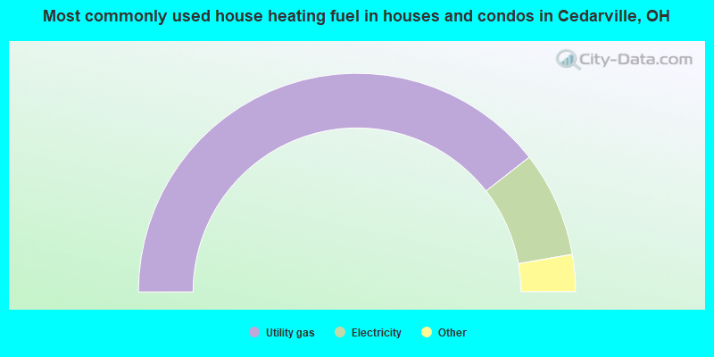
- 79.2%Utility gas
- 15.7%Electricity
- 3.9%Bottled, tank, or LP gas
- 1.2%Wood
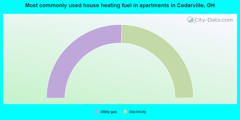
- 50.8%Utility gas
- 49.2%Electricity
Cedarville compared to Ohio state average:
- Median age significantly below state average.
- Foreign-born population percentage above state average.
- Renting percentage above state average.
- Length of stay since moving in significantly above state average.
- Number of college students significantly above state average.
- Percentage of population with a bachelor's degree or higher above state average.
Cedarville on our top lists:
- #22 on the list of "Top 101 cities with the largest percentage of people in college dormitories (includes college quarters off campus) (population 1,000+)"
- #42 on the list of "Top 101 cities where the highest percentage of males (15+ years) which never married (with at least 1,000 males in this group)"
- #45 on the list of "Top 101 cities where the highest percentage of females (15+ years) which never married (with at least 1,000 females in this group)"
- #96 on the list of "Top 101 cities with the most residents born in Other South America (population 500+)"
- #21 on the list of "Top 101 counties with the lowest surface withdrawal of fresh water for public supply (pop. 50,000+)"
- #84 on the list of "Top 101 counties with the highest percentage of residents relocating from foreign countries between 2010 and 2011 (pop. 50,000+)"
- #87 on the list of "Top 101 counties with the lowest Particulate Matter (PM10) Annual air pollution readings in 2012 (µg/m3)"
- #101 on the list of "Top 101 counties with the largest number of children under 18 without health insurance coverage in 2000 (pop. 50,000+)"

|
|
Total of 16 patent applications in 2008-2024.